Lake Eacham (Queensland)

Last updated

Lake Eacham
(Yidyam or Wiinggina)
Yidyam.jpg
View of Lake and Lake's edge from a Queensland National Parks viewing platform.
Australia relief map.jpg
Red pog.svg
Lake Eacham
(Yidyam or Wiinggina)
Australia Queensland relief location map.jpg
Red pog.svg
Lake Eacham
(Yidyam or Wiinggina)
Location Atherton Tableland, Queensland, Australia
Coordinates 17°17′06″S145°37′30″E / 17.285°S 145.625°E / -17.285; 145.625
Type Crater lake
Basin  countriesAustralia
Surface area529,582.77 m2 (5,700,381.5 sq ft)
Average depth38 m (125 ft)
Max. depth66 m (217 ft)
Water volume19,507,640.5 m3 (688,905,820 cu ft)

Lake Eacham (originally Yidyam or Wiinggina) is a popular lake of volcanic origin on the Atherton Tableland of Queensland, Australia, within the World Heritage listed Wet Tropics of Queensland. [1] [2] It is within the locality of Lake Eacham in the Tablelands Region local government area. [3]

Contents

Origins

Geology

Lake Eacham (Yidyam) was formed over 9,130 years ago [4] when molten magma from the Earth's mantle rose to the surface and heated the water table. The steam that resulted from the boiling water was trapped underground, until massive explosions signalled its release. Huge cracks appeared in the ground and the trees that once lathed the mountainside were levelled and burnt. Eventually, after the eruptions, groundwater filled the crater and the trees grew back, creating the tranquil lake used today by families and tourists for recreation. There are no streams that flow into or out the lake, water is only lost through soakage and evaporation and only replenished through rainfall, the level can fluctuate up to 4 metres between wet and dry seasons. [5] The nearby Lake Barrine formed in a similar way, over 17,300 years ago. [4]

Mythology

The local Ngadjon -jii (Aboriginal peoples), name the lake Wiinggina and tell a parallel story of the lake's origins, as follows [6]

"Two young fellas were trying to spear that wallaby. But they missed and hit a flame tree. That’s a sacred tree. The young fellas not supposed to be out hunting. They weren’t initiated. Their elders told them to stay put, not go out hunting. But they didn’t listen. When they pulled their spear out, part of a grub came out with the spear, which was a witchetty grub. They started cutting down that tree to get more grubs. When they cut down that tree, the ground began to shake. Those two fellas had made Yamini (rainbow serpent) angry. Then the sky turned orange, then all these people back at the camp, the earth went from underneath them, sucked them in, whoosh, they all got drowned. Where they were camped became Bana Wiingina (Lake Eacham)." (Warren Cannendo, Ngadjon-Jii)

This story, in all its local versions, is part of an indigenous oral history and mythology believed to be an oral record recalling those volcanic events more than 10,000 years old. [2]

European history

Lake Eacham guest house circa 1940 LakeEacham1.jpg
Lake Eacham guest house circa 1940

Back in 1886, Lake Eacham (Yidyam) was included within original survey plans subdividing the whole of the Lake Eacham area into farming blocks. [6] By 1888, however, the scenic value of the lake was recognised, and both the lake plus a narrow band of 'shoreline' rainforest were formally proclaimed "scenic reserve". [6] For almost 50 years (1888–1936) the Lake was managed, used and enjoyed as a scenic reserve, with, at times, boats and boating; a guest house; speed boats; and watersking. [6]

In 1934, the Queensland Government declared the lake and immediate surrounds be protected and managed as Lake Eacham National Park. [6] In 1988, UNESCO declared the Wet Tropics of Queensland a World Heritage Site with 14 areas protected, two of which were 484 hectares (1,200 acres) at Lake Barrine and 505 hectares (1,250 acres) at Lake Eacham. [7] In 1994, the Queensland Government merged Lake Barrine National Park and Lake Eacham National Park to form Crater Lakes National Park. [8]

Eacham war memorial, 2006 Eacham warmemorial.JPG
Eacham war memorial, 2006

A closed ecosystem and a near-extinction

Lake Eacham (Yidyam) is isolated from any other watercourse (making it an enclosed catchment). How any fish arrived there to begin with is a mystery, but somehow, the Lake Eacham rainbowfish (Melanotaenia eachamensis) found its way into the volcanic lake. Unfortunately for the small species, other larger fish were introduced into this closed system and eventually, these larger fish ate the Lake Eacham rainbowfish into extinction - at least as far as the lake was concerned. [9]

Aquarists had been collecting the fish from the Lake Eacham National Park (illegally) and were very successful at breeding them. These private collections became the source stock to reintroduce the fish to the lake. However, the cause of the species' initial demise was still living in the lake and proceeded to deplete the entire population of reintroduced stock. Ichthyologists working in the rivers and streams of the Atherton Tableland have found the Lake Eacham rainbowfish in the Tully, Herbert and Johnstone Rivers and Dirran Creek. [9]

In addition to the rainbowfish, Lake Eacham has two native fish species: The gudgeon Mogurnda adspersa and the hardyhead Craterocephalus stercusmuscarum . Other fish in the lake are non-native human introductions.

Protected area status

Aerial view of Lake Eacham, looking towards the north-east. Lake Eacham.jpg
Aerial view of Lake Eacham, looking towards the north-east.

Lake Eacham (Yidyam) is the main feature of the 4.89-square-kilometre (1.89 sq mi) Crater Lakes National Park, with a dense rainforest and thousands of small animals. It is therefore a protected area under Queensland State legislation (Nature Conservation Act 1994), and, as such, the natural and cultural resources most closely associated with the lake are protected and managed by the Queensland National Parks and Wildlife Service.

The lake has an average depth of 38 metres (125 ft) with a maximum depth of 65.5 m (215 ft) [10] and is considered by locals as being ideal for swimming, canoeing, bushwalking, and bird watching. No motor boats are allowed on the lake. It features a pontoon great for diving into the deep water. A large grassy area is set aside for recreation. There is a circuit walk around the lake that takes around 45 minutes to complete. There are also a population of turtles that can usually be seen just to the left of the pontoon. [6]

See also

Related Research Articles

<span class="mw-page-title-main">Crater Lakes National Park</span> Protected area in Queensland, Australia

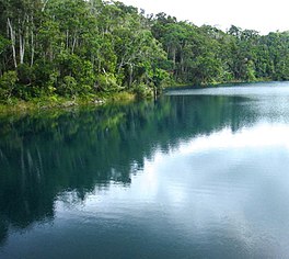
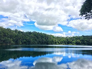
Crater Lakes is a national park in Far North Queensland, Queensland, Australia, 1367 km northwest of Brisbane. The park contains two volcanically-formed lakes, Lake Barrine and Lake Eacham (Yidyam). Both lakes have walking trails around each lake; boat tours are also given at Lake Barrine.

<span class="mw-page-title-main">Yungaburra</span> Town in Queensland, Australia

Yungaburra is a rural town and locality in the Tablelands Region, Queensland, Australia. In the 2016 census, the locality of Yungaburra had a population of 1,239 people.

<span class="mw-page-title-main">Atherton Tableland</span> Fertile plateau in northern Queensland, Australia

The Atherton Tableland is a fertile plateau, which is part of the Great Dividing Range in Queensland, Australia. It has very deep, rich basaltic soils and the main industry is agriculture. The principal river flowing across the plateau is the Barron River, which was dammed to form the irrigation reservoir named Lake Tinaroo. Unlike many other rural areas, the Tablelands is experiencing a significant growth in population.

<span class="mw-page-title-main">Lake Barrine</span> Volcanic crater lake in Queensland, Australia

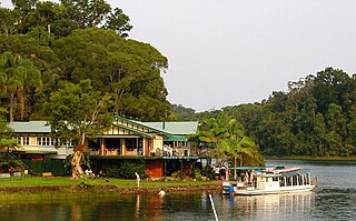
Lake Barrine is a freshwater lake on the eastern parts of Atherton Tableland in the locality of Lake Barrine, in the Tablelands Region of Far North Queensland, Australia, close to Lake Eacham. The lake and surrounds are protected within the Crater Lakes National Park and are accessible via the Gillies Highway.

<span class="mw-page-title-main">Tinaroo Dam</span> Dam in Far North Queensland

The Tinaroo Dam, officially the Tinaroo Falls Dam, is a major ungated concrete gravity dam with a central ogee spillway across the Barron River located on the Atherton Tableland in Far North Queensland, Australia. The dam's purpose includes irrigation for the Mareeba-Dimbulah Irrigation Scheme, water supply, hydroelectricity generation, and recreation. Completed between 1953 and 1958, the dam creates the impounded reservoir, Lake Tinaroo.

<span class="mw-page-title-main">The Pinnacles (Atherton Tableland)</span>

The Pinnacles are a series of seven volcanic cinder cones on the Atherton Tableland, near Yungaburra, Queensland, Australia. They were formed more than 350,000 years ago.

<span class="mw-page-title-main">Atherton State High School</span> Public school in Atherton, Queensland, Australia

Atherton State High School (ASHS) is a co-educational, state secondary school in Atherton, Tablelands Region, Queensland, Australia.

The Mount Hypipamee Crater, also known as The Crater, is a huge diatreme located south-east of Herberton on the Atherton Tableland in Far North Queensland, Australia. It is 61 metres in diameter and 82 metres deep.

<span class="mw-page-title-main">Shire of Eacham</span> Local government area in Queensland, Australia

The Shire of Eacham was a local government area of Queensland. It was located on the Atherton Tableland, a plateau forming part of the Great Dividing Range west of the city of Cairns. The shire, administered from the town of Malanda, covered an area of 1,126.4 square kilometres (434.9 sq mi), and existed as a local government entity from 1910 until 2008, when it amalgamated with several other councils in the Tableland area to become the Tablelands Region.

<span class="mw-page-title-main">Shire of Atherton</span> Local government area in Queensland, Australia

The Shire of Atherton was a local government area of Queensland. It was located on the Atherton Tableland, a plateau forming part of the Great Dividing Range west of the city of Cairns. The shire, administered from the town of Atherton, covered an area of 623.1 square kilometres (240.6 sq mi), and existed as a local government entity from 1881 until 2008, when it amalgamated with several other councils in the Tableland area to become the Tablelands Region.

<span class="mw-page-title-main">Gillies Highway</span>

The Gillies Highway is a road that runs from Gordonvale in the Cairns Region through the Gillies Range to Atherton in the Tablelands Region, both in Queensland, Australia. Its official name is Gillies Range Road, and it was originally known as the Cairns Range Road.

<span class="mw-page-title-main">Lake Euramoo</span> Lake in Queensland, Australia

Lake Euramoo is a shallow dumbbell-shaped volcanic crater lake in Danbulla, Tablelands Region, Far North Queensland, Australia. It was formed about 23,000 years ago by two massive explosions from groundwater superheating.

<span class="mw-page-title-main">Lake Eacham, Queensland</span> Suburb of Tablelands Region, Queensland, Australia

Lake Eacham is a rural locality in the Tablelands Region, Queensland, Australia. In the 2021 census, Lake Eacham had a population of 459 people.

Nungabana, also known as George Gilbert Davis, was the last elder of the Mullanburra people of Queensland, Australia.

<span class="mw-page-title-main">Malanda Falls Swimming Pool</span> Historic site in Queensland, Australia

Malanda Falls Swimming Pool is a heritage-listed swimming pool at Malanda Falls Park, Malanda, Tablelands Region, Queensland, Australia. It was built from 1906 onwards. It was added to the Queensland Heritage Register on 5 February 2010.

<span class="mw-page-title-main">Lake Eacham Hotel</span> Historic site in Queensland, Australia

Lake Eacham Hotel is a heritage-listed hotel at 6–8 Kehoe Place, Yungaburra, Tablelands Region, Queensland, Australia. It was built in 1910 by Side Brothers. It was added to the Queensland Heritage Register on 21 October 1992.

<span class="mw-page-title-main">Yungaburra Community Centre</span> Historic site in Queensland, Australia

Yungaburra Community Centre is a heritage-listed community hall at 19 Cedar Street, Yungaburra, Tablelands Region, Queensland, Australia. It was built from 1910 to c. 1926. It is also known as Tivoli picture theatre, Williams Estate Hall, and Yungaburra Hall. It was added to the Queensland Heritage Register on 21 October 1992.

The Ngajanji, also written Ngadyan, and Ngadjon-Jii are an Indigenous Australian people of the rainforest region south of Cairns, in northern Queensland. They form one of 8 groups, the others being Yidin, Mamu, Dyirbal, Girramay, Warrgamay, Waruŋu and Mbabaram, of the Dyirbal tribes.

<span class="mw-page-title-main">Lake Barrine, Queensland</span> Suburb of Tablelands Region, Queensland, Australia

Lake Barrine is a rural locality in the Tablelands Region, Queensland, Australia. In the 2021 census, Lake Barrine had a population of 170 people.

<span class="mw-page-title-main">Danbulla, Queensland</span> Suburb of Tablelands Region, Queensland, Australia

Danbulla is a locality in the Tablelands Region, Queensland, Australia. In the 2021 census, Danbulla had a population of 88 people.

References

  1. "Lake Eacham – lake (entry 10992)". Queensland Place Names. Queensland Government . Retrieved 22 June 2017.
  2. 1 2 Ngadjonji - Earthwatch web page. Archived 2 February 2008 at the Wayback Machine Accessed 5 November 2007.
  3. "Queensland Globe". State of Queensland . Retrieved 12 November 2019.
  4. 1 2 Head, M. J.; Taylor, L. J.; Walker, D. (1994). "ANU Radiocarbon Date List XI: Radiocarbon Dates from Lakes Barrine and Eacham, Atherton Tableland, North Queensland, Australia". Radiocarbon. 36 (1): 73–94. doi: 10.1017/S003382220001434X . ISSN   0033-8222.
  5. "Lake Eacham, Crater Lakes National Park". Department of National Parks, Recreation, Sport and Racing. 17 October 2012. Retrieved 29 December 2012.
  6. 1 2 3 4 5 6 "Nature, culture and history". Department of National Parks, Recreation, Sport and Racing. 17 October 2012. Retrieved 29 December 2012.
  7. "Wet Tropics of Queensland". World Heritage List . UNESCO. Archived from the original on 15 November 2018. Retrieved 15 November 2018.
  8. "Crater Lakes National Park Management Statement 2013" (PDF). Department of National Parks, Recreation, Sport and Racing. Queensland Government. Archived (PDF) from the original on 15 November 2018. Retrieved 15 November 2018. Alt URL
  9. 1 2 Wet Tropics Management Authority's Story of the Lake Eacham Rainbow Fish Archived 21 October 2007 at the Wayback Machine Accessed 11 November 2007
  10. Timms, B.V. (1976). "Morphology of Lakes Barrine, Eacham and Euramoo, Atherton Tableland, North Queensland". Proceedings of the Royal Society of Queensland. 87: 81–84.