Lakes of Bhutan

Last updated
Glacial lakes in Bhutan (2002) Glacial lakes, Bhutan.jpg
Glacial lakes in Bhutan (2002)

The lakes of Bhutan comprise its glacial lakes and its natural mountain lakes. Bhutanese territory contains some 2,674 high altitude glacial lakes and subsidiary lakes, out of which 25 pose a risk of GLOFs. [1] [2] There are also more than 59 natural non-glacial lakes in Bhutan, covering about 4,250 hectares (16.4 sq mi). Most are located above an altitude of 3,500 metres (11,500 ft), and most have no permanent human settlements nearby, though many are used for grazing yaks and may have scattered temporary settlements. [3] [4]

Contents

Only four lakes are below an altitude of 2,000 metres (6,600 ft): the temperate Ho Ko Tsho in Punakha District at 1,829 metres (6,001 ft); Luchika in Wangdue Phodrang at 1,830 metres (6,000 ft); Buli in Zhemgang at 1,372 metres (4,501 ft); and the subtropical Gulandi in Samdrup Jongkhar at 366 metres (1,201 ft). [3] [4] [5]

As phenomena of nature, all lakes in Bhutan are believed to be inhabited by spirits. [6] :27 A handful of lakes in Bhutan are particularly sacred, most often connected to lives of Buddhist saints Guru Rimpoche and Pema Lingpa. For example, Membar Tsho ("Burning Lake"), in the Tang Valley near Bumthang, is heavily associated with Guru Rimpoche, who brought Buddhism to Bhutan and discovered his first terma in the lake in 1475. [7] :21,29,177

Most natural lake names are denoted with the word tsho, meaning "lake" (Dzongkha: མཚོ་; Wylie: mtsho). [8] They may be identified as an individuals, pairs, or groups of lakes.

Glaciers and glacial lakes

Satellite image of Bhutan in April 2002.jpg
Satellite image of Bhutan (April 2002)
Bhutan topo en.jpg
Topographical map of Bhutan (2006)
Glaciers in Bhutan cover a substantial portion of its northern regions.

Bhutan contains some 2,674 glacial lakes. [1] [2] Some glacial lakes, such as Thorthormi Lake in Lunana Gewog, are not a single bodies of water but collections supraglacial ponds. [9] Most glacial lakes identified as potentially dangerous feed into the Manas River and Puna Tsang (Sankosh) River water systems of north-central Bhutan. [10] During a GLOF, residents of nearby downstream villages may have as little as twenty minutes to evacuate; floodwaters from one 1994 GLOF at Luggye lake took about seven hours to reach Punakha, some 90 kilometres (56 mi) downstream. [11]

Where glacial movement temporary blocks riverflows, downstream areas may be threatened by glacial lake outburst flood ("GLOFs"). [12] [13] Although GLOFs are not a new phenomenon in Bhutan, their frequency has risen in the past three decades. [1] [14] Significant GLOFs occurred in 1957, 1960, 1968 and 1994, devastating lives and property downstream. [15] According to the Bhutan Department of Energy however, the majority of rivers in Bhutan are more susceptible to fluctuation with changing rainfall patterns than to flooding directly attributable to glacier or snow melt. [16]

For public safety, these glaciers and glacial lakes are maintained by the Ministry of Economic Affairs' Department of Geology and Mines, an executive (cabinet) agency of the government of Bhutan. [17] The Department, as part of its environmental "mitigation projects," aims to lower the levels of glacial lakes and thereby avert GLOF-related disaster. One such glacial lake mitigation project, for example, aimed to lower water levels by five meters over three years. The Department uses silent explosives and other means it considers environmentally friendly in order to minimize the ecological impact of its mitigation projects. These projects, however, remain difficult to conduct because of the weather, terrain, and relative lack of oxygen at the glacial lakes' altitudes. As of September 2010, GLOF early warning systems were slated for installation by mid-2011 in Punakha and Wangdue Phodrang Districts at a cost of USD4.2 million. [2] [18]

Lists of lakes

List of non-glacial lakes

Naturally occurring mountain lakes, though today fewer than glacial lakes, include several historically and spiritually relevant bodies of water.

Lake name District Gewog Notes
Animo Tsho Bumthang District Chhoekhor Gewog Located near Dhur, Animo Tsho sits at an elevation of 4,375 metres (14,354 ft) on the road from Bumthang to Lunana. It is a holy lake where speech is forbidden. [6] :239
Buli Tsho Zhemgang District The Buli sits at 1,372 metres (4,501 ft). [3] [4] [5]
Chhiba Tsho Dagana District Chhiba Tsho is located below a pass at 4,500 metres (14,800 ft). On the other side of the pass lie Dagana Valley and the small, blue Langtsho ("Ox Lake"). [6] :205
Chungge Tsho Bumthang District Chhoekhor Gewog Chungge Tsho is at an elevation of 4,400 metres (14,400 ft), near Lungsipang village. [6] :256
Dagebho Thimphu District Soe Gewog east Jomo lake group; its name means "longer than the archery range," and is also called Batsho. [6] :200
Daja Tsho Thimphu District Soe Gewog Jomo lake group; Daja Tsho is also called Serbho Tsho ("Golden Lake"). [6] :200,202 It lies along the Snowman Trek at 4,520 metres (14,830 ft) [7] :215
Dangling Tsho Trashigang District Khaling Gewog Located to the north of Khaling village, the lake is considered very sacred by the local people. [19]
Djule Tsho Bumthang District Chhoekhor Gewog Djule Tsho is located to the northwest of the sacred Animo Tsho at 4,190 metres (13,750 ft) near the Gongto La (Gokthong La) and Djule La passes. This pass marks the watershed of the Mangde Chhu (Trongsa Chhu), one of Bhutan's major river systems. [6] :239
Dongney Tsho Paro District Tsento Gewog Dongney Tsho is surrounded by fir trees, located on the trekking path to Drugyel Dzong. [6] :66
Dongtsho Thimphu District Soe Gewog east Jomo lake group. [6] :200
Dungtsho Tsho Paro District Doteng Gewog Dungtsho Tsho and Dungtsho Sama, male and female lakes, respectively. [6] :190
Gulandi Tsho Samdrup Jongkhar District The subtropical Gulandi sits at 366 metres (1,201 ft). [3] [4] [5]
Ho Ko Tsho Punakha District The Ho Ko Tsho sits at 1,829 metres (6,001 ft). [3] [4] [5]
Janye Tsho Thimphu District Lingzhi Gewog Janye, or Jane, Tsho rests at 3,956 metres (12,979 ft) along the Druk Path Trail between Jimilang Tsho and Simkotra Tsho. It is often occupied by yak herders. [6] :190
Jatsho Thimphu District Soe Gewog Jomo lake group; the largest lake of its group, its name ("Vulture Lake"), comes from its shape. [6] :200
Jimilang Tsho Thimphu District Jimilang rests at an elevation of 3,870 metres (12,700 ft) at the apex of the Druk Path Trail. Its name means "Sand Ox Lake," named after a legendary bull. [7] :214 Also called Bimelang Tsho, this sacred lake is a meditation site. The lake contains many trout, and fishing there is allowed with permit. [6] :188,191
Laname Tsho Paro District Tsento Gewog Laname Tsho is near Laname La and Bonte La passes. [6] :159
Langtsho Dagana District Langtsho ("Ox Lake") is a small lake adjacent to the Mangde Chhu watershed. [6] :205
Luetshokha Tsho Wangdue Phodrang District Luetshokha sits at 1,830 metres (6,000 ft). [3] [4] [5] The lake is located on the way to Samtengang village.
Membar Tsho Bumthang District "Burning Lake", in the Tang Valley near Bumthang, is heavily associated with Guru Rimpoche, who brought Buddhism to Bhutan and discovered his first terma in the lake in 1475. [7] :21,29,177
Ngyetsho Thimphu District Soe Gewog east Jomo lake group. [6] :200
Nob Tshona Patta Tsho Haa District Uesu Gewog Nob Tshona Patta Tsho is a treking destination from Haa to Paro near Lukha village. [6] :67,70
Om Tsho Trongsa District Nubi Gewog Om Tsho, also called Omtoe Tsho and Omta Tsho, lies at 4,665 metres (15,305 ft). It is a sacred lake, believed to be where Pema Lingpa found terton: cymbals, texts, and other artifacts hidden by Guru Rimpoche. There is a second smaller lake below the waterfall of Om Tsho at 4,150 metres (13,620 ft); both are located along the Snowman Trek. [6] :141
Rigona Tsho Paro District Tsento Gewog Rigona is near Nob Tshona Patta Tsho at 4,090 metres (13,420 ft). [6] :71
Sertsho Thimphu District Soe Gewog east Jomo lake group. [6] :200
Sethag Burge Tsho Gasa District Laya Gewog Also called Sistiha Phugi Tso, this lake lies below the enormous Tsenda Gang range. [6] :178
Setsho Gasa District Lunana Gewog Setsho lake is located southwest of Gonju La along the Ramena Trail near Woche [6] :123
Simdong Goi Tso Gasa District Laya Gewog This lake lies between Wochey and the Wagye La pass, the old route to Lhasa. [6] :178
Simkotra Tsho Thimphu District Naro Gewog Simkotra Tsho is located to the south of Jimilang Tsho along the Druk Path Trail at 4,090 metres (13,420 ft). [6] :190
Solang Chhu Bumthang District Chhoekhor Gewog Solang Chhu (Thole Tsho) is an alpine lake at 4,420 metres (14,500 ft) near Bopsar and Thole La pass. [6] :264
Tampoe Tsho Trongsa District Nubi Gewog Tampoe Tsho is a small lake near Om Tsho.
Tshochena Lake Gasa District Lunana Gewog Tshochena is located along the Snowman Trek, at 4,970 metres (16,310 ft). [7] :240
Tsho Phu Paro District Tsento Gewog The Tsho Phu are a pair of lakes along the Snowman Trek at 4,380 metres (14,370 ft). [7] :221 Although they were stocked with brown trout in the 1960s, fishing there is prohibited. [6] :149
Utsho Tsho Thimphu Soe Gewog Jomo lake group; Utsho is also called Gewa Tsho ("Turquoise Lake"), and is the lowsest of the Jomo lakes. [6] :200
Adha Tsho Wangdue Phodrang Athang Gewog Ada Tsho is beautifully located within the warm broadleaved forest near a paddy field.

List of glacial lakes

Glacial lakes in Bhutan far outnumber other kinds of lakes, and pose a particular risk to those living downstream in the event of a GLOF. Many of these lakes have appeared or grown after climate change, and the frequency at which they emit flood waters has increased. in recent history.

Below is a list of the major glacial lakes in Bhutan. Many lakes appear in clusters, and may someday merge; for example, the numerous glacial lakes of Laya and Lunana Gewogs lie mostly within Jigme Dorji National Park along a handful of major glaciers.

Lake name District Gewog Notes
Thorthormi Glacial Lake Gasa District Lunana Gewog Thorthormi Lake appeared on its glacier sometime after 1967. It is the largest lake in Lunana, with a width of 30 metres (98 ft). [2] [20]
Raphstreng (Rapstreng) Glacial Lake Gasa District Lunana Gewog This lake appeared on its glacier in 1958. It is just over 2 square kilometres (0.77 sq mi) and 107 metres (351 ft) deep. [9] [20] [21]
Luggye (Lugge) Glacial Lake Gasa District Lunana Gewog Luggye first appeared in 1967 atop its glacier. It has a depth of 142 metres (466 ft), and a width of 30 metres (98 ft). Luggye produced a significant GLOF in 1994. [9] [20] [21] [22]
Bechung Glacial Lake Gasa District Lunana Gewog Supra-glacial lake. [9] [20]
Roduphu Glacial Lake Gasa District Laya Gewog This lake feeds into the Mo Chhu (River) basin. [23]
Sinchhe Glacial Lake Gasa District Laya Gewog Sinchhe drains into the Mo Chhu (River) basin. [23]
Gangchentag Glacial Lake Gasa District Laya Gewog Located at the base of Gangchentag Mountain. [24] [25]
Wochey (Wachey) Glacial Lake Gasa District Laya Gewog Wochey Lake lies at an altitude of 4,220 metres (13,850 ft), just below the Gokthong La pass, [7] :239 on the single longest glacier in Bhutan at 20.1 kilometres (12.5 mi). [20]
Teri Kang Glacial Lake Gasa District Laya Gewog This dam-reinforced lake produced a devastating GLOF in the 1960s, partially destroying Punakha Dzong. [26]
Chubda Glacial Lake Bumthang District Located in the upper Chamkhar Chhu basin, this large supraglacial lake was identified as a potential danger in 2001. [27]
Taksha Tsho Glacial Lake Gasa District Lunana Gewog Taksha Tsho is 500 metres (1,600 ft) in diameter and 110 metres (360 ft) deep. [6] :131
Tsokar Glacial Lake Bumthang District Glacial lake in the basin. [23]

See also

Related Research Articles

<span class="mw-page-title-main">Geography of Bhutan</span>

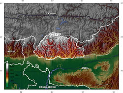
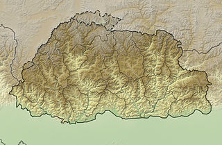
Bhutan is a sovereign country at the crossroads of East Asia and South Asia, located towards the eastern extreme of the Himalayas mountain range. It is fairly evenly sandwiched between the sovereign territory of two nations: first, the People's Republic of China (PRC) on the north and northwest. There are approximately 477 kilometres (296 mi) of border with the country's Tibet Autonomous Region (TAR), or simply Tibet. The second nation is the Republic of India on the south, southwest, and east; there are approximately 659 kilometres (409 mi) with the states of Arunachal Pradesh, Assam, West Bengal, and Sikkim, in clockwise order from the kingdom. Bhutan's total borders amount to approximately 1,139 kilometres (708 mi). The Indian state of Sikkim to the west, the India to the south, and the Assam state of India to the southeast are other close neighbours; the former two are separated by only very small stretches of Indian territory.

<span class="mw-page-title-main">Gasa District</span> District of Bhutan

Gasa District or Gasa Dzongkhag is one of the 20 dzongkhags (districts) comprising Bhutan. The capital of Gasa District is Gasa Dzong near Gasa. It is located in the far north of the county and spans the Middle and High regions of the Tibetan Himalayas. The dominant language of the district is Dzongkha, which is the national language. Related languages, Layakha and Lunanakha, are spoken by semi-nomadic communities in the north of the district. The People's Republic of China claims the northern part of Gasa District.

<span class="mw-page-title-main">Moraine-dammed lake</span> Type of lake formed by glaciation

A moraine-dammed lake, occurs when the terminal moraine has prevented some meltwater from leaving the valley. When a glacier retreats, there is a space left over between the retreating glacier and the piece that stayed intact which holds leftover debris (moraine). Meltwater from both glaciers seep into this space creating a ribbon-shaped lake due to the pattern of ice melt. This ice melt may cause a glacier lake outburst flood, leading to severe damage to the environment and communities nearby. Examples of moraine-dammed lakes include:

<span class="mw-page-title-main">Layap</span> Ethnic group

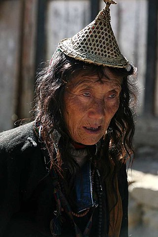
The Layap are an indigenous people inhabiting the high mountains of northwest Bhutan in the village of Laya, in the Gasa District, at an altitude of 3,850 metres (12,630 ft), just below the Tsendagang peak. Their population in 2003 stood at 1,100. They speak Layakha, a Tibeto-Burman language. Layaps refer to their homeland as Be-yul – "the hidden land."

<span class="mw-page-title-main">Punakha</span> Administrative centre in Punakha dzongkhag, Bhutan

Punakha is the administrative centre of Punakha dzongkhag, one of the 20 districts of Bhutan. Punakha was the capital of Bhutan and the seat of government until 1955, when the capital was moved to Thimphu. It is about 72 km away from Thimphu, and it takes about 3 hours by car from the capital. Unlike Thimphu, it is quite warm in winter and hot in summer. It is located at an elevation of 1,200 metres above sea level, and rice is grown as the main crop along the river valleys of two main rivers of Bhutan, the Pho Chu and Mo Chu. Dzongkha is widely spoken in this district.

<span class="mw-page-title-main">Glacial lake outburst flood</span> Type of outburst flood that occurs when the dam containing a glacial lake fails

A glacial lake outburst flood (GLOF) is a type of outburst flood caused by the failure of a dam containing a glacial lake. An event similar to a GLOF, where a body of water contained by a glacier melts or overflows the glacier, is called a jökulhlaup. The dam can consist of glacier ice or a terminal moraine. Failure can happen due to erosion, a buildup of water pressure, an avalanche of rock or heavy snow, an earthquake or cryoseism, volcanic eruptions under the ice, or massive displacement of water in a glacial lake when a large portion of an adjacent glacier collapses into it.

<span class="mw-page-title-main">Jakar</span> Thromde in Bumthang, Bhutan

Jakar is a town in the central-eastern region of Bhutan. It is the district capital of Bumthang District and the location of Jakar Dzong, the regional dzong fortress. The name Jakar roughly translates as "white bird" in reference to its foundation myth, according to which a roosting white bird signalled the proper and auspicious location to found a monastery around 1549.

<span class="mw-page-title-main">Wangdue Phodrang</span> Place in Wangdue Phodrang District, Bhutan

Wangdue Phodrang is a town and capital of Wangdue Phodrang District in central Bhutan. It is located in Thedtsho Gewog. Khothang Rinchenling

<i>Bhutan Observer</i> Bhutans first private bilingual newspaper

The Bhutan Observer was Bhutan's first private bilingual newspaper. It was launched as a private limited company by parent company Bhutan Media Services (BMS), and began publishing on June 2, 2006, in Thimphu. Its Dzongkha edition was called Druk Nelug, and the newspaper maintained an online service in English until 2013.

<span class="mw-page-title-main">Jigme Dorji National Park</span> National Park of Bhutan

The Jigme Dorji National Park (JDNP), named after the late Jigme Dorji Wangchuck, is the second-largest National Park of Bhutan.

<span class="mw-page-title-main">Punakha Dzong</span> Administrative centre in Punakha, Bhutan

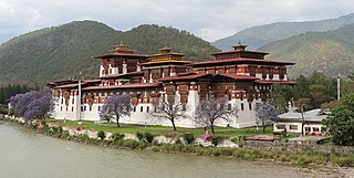
The Punakha Dzong, also known as Pungthang Dewa chhenbi Phodrang, is the administrative centre of Punakha District in Punakha, Bhutan. Constructed by Ngawang Namgyal, 1st Zhabdrung Rinpoche, in 1637–38, it is the second oldest and second-largest dzong in Bhutan and one of its most majestic structures. The dzong houses the sacred relics of the southern Drukpa Lineage of the Kagyu school of Tibetan Buddhism, including the Rangjung Kharsapani and the sacred remains of Ngawang Namgyal and the tertön Pema Lingpa.

The glaciers in Bhutan, which covers about 3 percent of the total surface area, are responsible for feeding all rivers of Bhutan except the Amochu and Nyere Amachu.

<span class="mw-page-title-main">Thrumshing La</span> Mountain pass in Bhutan

Thrumshing La, also called Thrumshingla Pass and Donga Pass,, is the second-highest mountain pass in Bhutan, connecting its central and eastern regions across the otherwise impregnable Donga range that has separated populations for centuries. It is located on a bend of the Lateral Road at the border of Bumthang District and Mongar District, along the border with Lhuntse District to the east. The Lateral Road bisects Thrumshingla National Park, named after the pass. The World Wildlife Fund also maintains operations in the park.

HIV/AIDS in Bhutan remains a relatively rare disease among its population. It has, however, grown into an issue of national concern since Bhutan's first reported case in 1993. Despite preemptive education and counseling efforts, the number of reported HIV/AIDS cases has climbed since the early 1990s. This prompted increased government efforts to confront the spread of the disease through mainstreaming sexually transmitted disease (STD) and HIV prevention, grassroots education, and the personal involvement of the Bhutanese royal family in the person of Queen Mother Sangay Choden.

<span class="mw-page-title-main">Environmental issues in Bhutan</span>

Among Bhutan's most pressing environmental issues are traditional firewood collection, crop and flock protection, and waste disposal, as well as modern concerns such as industrial pollution, wildlife conservation, and climate change that threaten Bhutan's population and biodiversity. Land and water use have also become matters of environmental concern in both rural and urban settings. In addition to these general issues, others such as landfill availability and air and noise pollution are particularly prevalent in relatively urbanized and industrialized areas of Bhutan. In many cases, the least financially and politically empowered find themselves the most affected by environmental issues.

<span class="mw-page-title-main">Energy in Bhutan</span>

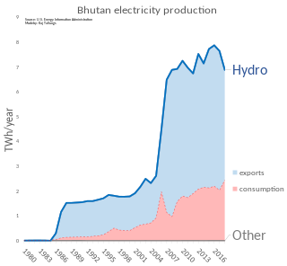
Energy in Bhutan has been a primary focus of development in the kingdom under its Five-Year Plans. In cooperation with India, Bhutan has undertaken several hydroelectric projects whose output is traded between the countries. Though Bhutan's many hydroelectric plants provide energy far in excess of its needs in the summer, dry winters and increased fuel demand makes the kingdom a marginal net importer of energy from India.

<span class="mw-page-title-main">Mountains of Bhutan</span> Highlands of Bhutan

The mountains of Bhutan are some of the most prominent natural geographic features of the kingdom. Located on the southern end of the Eastern Himalaya, Bhutan has one of the most rugged mountain terrains in the world, whose elevations range from 160 metres (520 ft) to more than 7,000 metres (23,000 ft) above sea level, in some cases within distances of less than 100 kilometres (62 mi) of each other. Bhutan's highest peak, at 7,570 metres (24,840 ft) above sea level, is north-central Gangkhar Puensum, close to the border with Tibet; the third highest peak, Jomolhari, overlooking the Chumbi Valley in the west, is 7,314 metres (23,996 ft) above sea level; nineteen other peaks exceed 7,000 metres (23,000 ft). Weather is extreme in the mountains: the high peaks have perpetual snow, and the lesser mountains and hewn gorges have high winds all year round, making them barren brown wind tunnels in summer, and frozen wastelands in winter. The blizzards generated in the north each winter often drift southward into the central highlands.

<span class="mw-page-title-main">Motithang Higher Secondary School</span> Government school in Bhutan

Motithang Higher Secondary School is a government high school in the capital city of Thimphu, Bhutan. It was established in the year 1975. Motithang translates to The Meadow of Pearls in English.

References

  1. 1 2 3 Tirwa, Badan (2008-01-19). "Managing health disaster". Thimphu: Bhutan Observer online. Archived from the original on 2011-01-20. Retrieved 2011-03-27.
  2. 1 2 3 4 Pelden, Sonam (2010-09-03). "Thorthormi water level brought down 43 cm". Bhutan Observer online. Archived from the original on 2011-01-19. Retrieved 2011-03-27.
  3. 1 2 3 4 5 6 Bisht, Ramesh Chandra (January 2008). International Encyclopaedia Of Himalayas. Mittal Publications. pp. 34–5. ISBN   978-81-8324-265-3.
  4. 1 2 3 4 5 6 "Survey of the Waters of Bhutan – Physiography and Fisheries Potential". United Nations Food and Agriculture Organization. December 1978. Retrieved 2011-11-26.
  5. 1 2 3 4 5 "Survey of the Waters of Bhutan – Physiography and Fisheries Potential". United Nations Food and Agriculture Organization. December 1978. Retrieved 2011-11-26.
  6. 1 2 3 4 5 6 7 8 9 10 11 12 13 14 15 16 17 18 19 20 21 22 23 24 25 26 27 28 Jordans, Bart (2008). Bhutan: A Trekker's Guide (2 ed.). Cicerone Press Limited. ISBN   978-1-85284-553-7 . Retrieved 2011-11-26.
  7. 1 2 3 4 5 6 7 Brown, Lindsay; Armington, Stan (2007). Bhutan (3 ed.). Lonely Planet. pp. 62, 105, 108, 113. ISBN   978-1-74059-529-2 . Retrieved 2011-11-25.
  8. "༈ རྫོང་ཁ་ཨིང་ལིཤ་ཤན་སྦྱར་ཚིག་མཛོད། ༼མཚ-༽" [Dzongkha-English Dictionary: "MTSHA"]. Dzongkha-English Online Dictionary. Dzongkha Development Commission, Government of Bhutan. Archived from the original on 2011-08-25. Retrieved 2011-10-30.
  9. 1 2 3 4 Pelden, Sonam (2009-10-09). "Thorthormi water level brought down". Bhutan Observer online. Archived from the original on 2011-01-19. Retrieved 2011-03-27.
  10. "Bhutan's glaciers and glacial lakes". RAO online. 2010-12-05. Retrieved 2011-04-24.
  11. "Watching the lakes". RAO online. 2010-12-05. Retrieved 2011-04-24.
  12. "Fighting glacial lake floods". Bhutan Observer online. 2009-05-22. Archived from the original on 2011-01-19. Retrieved 2011-03-27.
  13. Dahal, Rabi C (2008-10-31). "Glacial lake outburst a real threat". Bhutan Observer online. Archived from the original on 2011-01-19. Retrieved 2011-03-27.
  14. "Department of Geology and Mines". Government of Bhutan. 2009-08-25. Retrieved 2011-03-27.[ permanent dead link ]
  15. Rinchen, Sonam (2008-09-16). "Monitoring climate change". Bhutan Observer online. Archived from the original on 2011-01-19. Retrieved 2011-03-27.
  16. Pelden, Sonam (2010-04-02). "Looking beyond hydropower". Bhutan Observer online. Archived from the original on 2011-10-03. Retrieved 2011-03-27.
  17. "Tengye Lhenkag – Ministry of Economic Affairs". Government of Bhutan. Archived from the original on 2010-07-27. Retrieved 2011-03-27.
  18. Prime Minister (2010-07-02). "Prime Minister's State of the Nation address, 2009–2010 (IV. Environment – Mitigation and Adaptive Measures)". Bhutan Observer online. Archived from the original on 2011-01-19. Retrieved 2011-03-27.
  19. "Wish-granting lake is leaving its home – Kuensel Online". kuenselonline.com. Retrieved 7 January 2021.
  20. 1 2 3 4 5 Choden, Kuenzang C (2009-08-21). "A major GLOF in 2010?". Bhutan Observer online. Archived from the original on 2011-10-03. Retrieved 2011-03-27.
  21. 1 2 Pelden, Sonam (2009-10-21). "Up against the raw nature". Lunana: Bhutan Observer online. Archived from the original on 2012-03-20. Retrieved 2011-03-27.
  22. "Lakes in Lunana with high GLOF (glacial lake outburst flood) risks". RAO online. 2010-12-05. Retrieved 2011-04-24.
  23. 1 2 3 "Glaciers, Glacial Lakes, and GLOF-related Reports". Department of Geology and Mines. Government of Bhutan. 2007-10-11. Retrieved 2011-04-24.[ permanent dead link ]
  24. "Trip Itinerary for 2011 Takin Festival at Tsharijathang (9–10 June 2011)" (PDF). Tourism Council of Bhutan online. Government of Bhutan. 2011. Archived from the original (PDF) on 1 August 2013. Retrieved 2011-04-24.
  25. "Keys to Bhutan Adventures and Holidays". Tourism Council of Bhutan online. Government of Bhutan. 2011. Retrieved 2011-04-24.
  26. "Snowman Trek I (to Sephu)". Tourism Council of Bhutan online. Government of Bhutan. 2008-08-26. Archived from the original on 2011-04-25. Retrieved 2011-04-24.
  27. Iwata, Shuji (2010). Richard S. Williams, Jr & Jane G. Ferrigno (ed.). "Glaciers of Bhutan — An Overview" (PDF). Glaciers of Asia: U.S. Geological Survey Professional Paper 1386–F. USGS.