
Canada has a vast geography that occupies much of the continent of North America, sharing a land border with the contiguous United States to the south and the U.S. state of Alaska to the northwest. Canada stretches from the Atlantic Ocean in the east to the Pacific Ocean in the west; to the north lies the Arctic Ocean. Greenland is to the northeast with a shared border on Hans Island. To the southeast Canada shares a maritime boundary with France's overseas collectivity of Saint Pierre and Miquelon, the last vestige of New France. By total area, Canada is the second-largest country in the world, after Russia. By land area alone, however, Canada ranks fourth, the difference being due to it having the world's largest proportion of fresh water lakes. Of Canada's thirteen provinces and territories, only two are landlocked while the other eleven all directly border one of three oceans.

The Gulf of St. Lawrence fringes the shores of the provinces of Quebec, New Brunswick, Nova Scotia, Prince Edward Island, Newfoundland and Labrador, in Canada, plus the islands Saint-Pierre and Miquelon, possessions of France, in North America.

The Continental Divide of the Americas is the principal, and largely mountainous, hydrological divide of the Americas. The Continental Divide extends from the Bering Strait to the Strait of Magellan, and separates the watersheds that drain into the Pacific Ocean from those river systems that drain into the Atlantic and Arctic Ocean, including those that drain into the Gulf of Mexico, the Caribbean Sea, and Hudson Bay.

Lake Agassiz was a large proglacial lake that existed in central North America during the late Pleistocene, fed by meltwater from the retreating Laurentide Ice Sheet at the end of the last glacial period. At its peak, the lake's area was larger than all of the modern Great Lakes combined.

A drainage basin is an area of land where all flowing surface water converges to a single point, such as a river mouth, or flows into another body of water, such as a lake or ocean. A basin is separated from adjacent basins by a perimeter, the drainage divide, made up of a succession of elevated features, such as ridges and hills. A basin may consist of smaller basins that merge at river confluences, forming a hierarchical pattern.

The Pigeon River forms part of the Canada–United States border between the state of Minnesota and the province of Ontario, west of Lake Superior. In pre-industrial times, the river was a waterway of great importance for transportation and the fur trade.
The Eastern Continental Divide, Eastern Divide or Appalachian Divide is a hydrological divide in eastern North America that separates the easterly Atlantic Seaboard watershed from the westerly Gulf of Mexico watershed. The divide nearly spans the United States from south of Lake Ontario through the Florida peninsula, and consists of raised terrain including the Appalachian Mountains to the north, the southern Piedmont Plateau and lowland ridges in the Atlantic Coastal Plain to the south. Water including rainfall and snowfall, lakes, streams and rivers on the eastern/southern side of the divide drains to the Atlantic Ocean; water on the western/northern side of the divide drains to the Gulf of Mexico. The ECD is one of six continental hydrological divides of North America which define several drainage basins, each of which drains to a particular body of water.

Triple Divide Peak is located in the Lewis Range, part of the Rocky Mountains in North America. The peak is a feature of Glacier National Park in the state of Montana in the United States. The summit of the peak, the hydrological apex of the North American continent, is the point where two of the principal continental divides in North America converge, the Continental Divide of the Americas and the Northern or Laurentian Divide.
Lake Traverse is an 11,200-acre (4,500 ha) lake along the border between the U.S. states of Minnesota and South Dakota, and is the southernmost body of water in the Hudson Bay watershed of North America. Lake Traverse is drained at its north end by the northward-flowing Bois de Sioux River, a tributary of the Red River of the North. A U.S. Army Corps of Engineers dam at the outflow regulates the lake's level. The Mustinka River flows into the lake just above the dam.

A drainage divide, water divide, ridgeline, watershed, water parting or height of land is elevated terrain that separates neighboring drainage basins. On rugged land, the divide lies along topographical ridges, and may be in the form of a single range of hills or mountains, known as a dividing range. On flat terrain, especially where the ground is marshy, the divide may be difficult to discern.

The history of post-confederation Canada began on July 1, 1867, when the British North American colonies of Canada, New Brunswick, and Nova Scotia were united to form a single Dominion within the British Empire. Upon Confederation, the United Province of Canada was immediately split into the provinces of Ontario and Quebec. The colonies of Prince Edward Island and British Columbia joined shortly after, and Canada acquired the vast expanse of the continent controlled by the Hudson's Bay Company, which was eventually divided into new territories and provinces. Canada evolved into a fully sovereign state by 1982.
The Hudson Bay drainage basin is the drainage basin in northern North America where surface water empties into the Hudson Bay and adjoining waters. Spanning an area of about 3,861,400 square kilometres (1,490,900 sq mi) and with a mean discharge of about 30,900 m3/s (1,090,000 cu ft/s), the basin is almost entirely within Canada. It encompasses parts of the Canadian Prairies, Central Canada, and Northern Canada. A small area of the basin is in the northern part of the Midwestern United States.
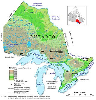
Ontario is located in East/Central Canada. It is Canada's second largest province by land area. Its physical features vary greatly from the Mixedwood Plains in the southeast to the boreal forests and tundra in the north. Ontario borders Manitoba to the west, Hudson Bay and James Bay to the north, Quebec to the east, and the Great Lakes and the United States to the south. The province is named for Great Lake Ontario, an adaptation of the Iroquois word Onitariio, meaning "beautiful lake", or Kanadario, variously translated as "beautiful water". There are approximately 250,000 lakes and over 100,000 kilometres (62,000 mi) of rivers in the province.

The U.S. State of Minnesota is the northernmost state outside Alaska; its isolated Northwest Angle in Lake of the Woods is the only part of the 48 contiguous states lying north of the 49th parallel north. Minnesota is in the U.S. region known as the Upper Midwest in interior North America. The state shares a Lake Superior water border with Michigan and Wisconsin on the northeast; the remainder of the eastern border is with Wisconsin. Iowa is to the south, South Dakota and North Dakota are to the west, and the Canadian provinces of Manitoba and Ontario are to the north. With 87,014 square miles (225,370 km2), or approximately 2.26% of the United States, Minnesota is the 12th largest state.

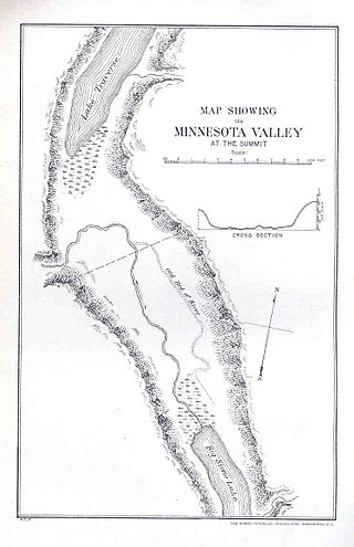
The Traverse Gap is an ancient river channel occupied by Lake Traverse, Big Stone Lake and the valley connecting them at Browns Valley, Minnesota. It is located on the border of the U.S. states of Minnesota and South Dakota. Traverse Gap has an unusual distinction for a valley: it is crossed by a continental divide, and in some floods, water has flowed across that divide from one drainage basin to the other. Before the Anglo-American Convention of 1818 it marked the border between British territory in the north and U.S. – or earlier, French – territory in the south.

A continental divide is a drainage divide on a continent such that the drainage basin on one side of the divide feeds into one ocean or sea, and the basin on the other side either feeds into a different ocean or sea, or else is endorheic, not connected to the open sea. Every continent on earth except Antarctica has at least one continental drainage divide; islands, even small ones like Killiniq Island on the Labrador Sea in Canada, may also host part of a continental divide or have their own island-spanning divide. The endpoints of a continental divide may be coastlines of gulfs, seas or oceans, the boundary of an endorheic basin, or another continental divide. One case, the Great Basin Divide, is a closed loop around an endorheic basin. The endpoints where a continental divide meets the coast are not always definite since the exact border between adjacent bodies of water is usually not clearly defined. The International Hydrographic Organization's publication Limits of Oceans and Seas defines exact boundaries of oceans, but it is not universally recognized. Where a continental divide meets an endorheic basin, such as the Great Divide Basin of Wyoming, the continental divide splits and encircles the basin. Where two divides intersect, they form a triple divide, or a tripoint, a junction where three watersheds meet.
Watersheds of North America are large drainage basins which drain to separate oceans, seas, gulfs, or endorheic basins. There are six generally recognized hydrological continental divides which divide the continent into seven principal drainage basins spanning three oceans and one endorheic basin. The basins are the Atlantic Seaboard basin, the Gulf of Mexico basin, the Great Lakes-St. Lawrence basin, the Pacific basin, the Arctic basin, the Hudson Bay basin, and the Great Basin. Together, the principal basins span the continent with the exception of numerous smaller endorheic basins.
A triple divide or triple watershed is a point on Earth's surface where three drainage basins meet. A triple divide results from the intersection of two drainage divides. Triple divides range from prominent mountain peaks to minor side peaks, down to simple slope changes on a ridge which are otherwise unremarkable. The elevation of a triple divide can be thousands of meters to barely above sea level. Triple divides are a common hydrographic feature of any terrain that has rivers, streams and/or lakes.

The Saint Lawrence River Divide is a continental divide in central and eastern North America that separates the Great Lakes-St. Lawrence River Basin from the southerly Atlantic Ocean watersheds. Water, including rainfall and snowfall, lakes, rivers and streams, north and west of the divide, drains into the Gulf of St. Lawrence or the Labrador Sea; water south and east of the divide drains into the Atlantic Ocean or Gulf of Mexico. The divide is one of six continental divides in North America that demarcate several watersheds that flow to different gulfs, seas or oceans.


