
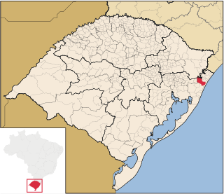
This is a list of the extreme points of Brazil .
This is a list of the extreme points of Brazil .
The following points are farther north, south, east or west than any other location.
São João, Portuguese for "Saint John", may refer to:

Santa Catarina Island is an island in the Brazilian state of Santa Catarina, located off the southern coast. It is home to the state capital, Florianópolis.
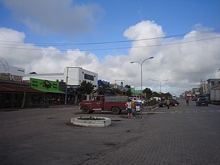
Chuí is a municipality located in the state of Rio Grande do Sul, Brazil. It's the southernmost town of Brazil, located in the coordinates 33°41′0″S. A border town, it shares its name with sister city Chuy, Uruguay. The two towns constitute one contiguous urban area, divided by a border street called Avenida Internacional, called Avenida Uruguai in Brazil, a situation also seen in a few other Brazilian border points, such as between Santana do Livramento (Brazil) and Rivera (Uruguay).

Mâncio Lima is the westernmost municipality of Brazil and it is located in the state of Acre. It is also the northernmost city of that state. Its population is 19,311 and its area is 4,672 km2. Its counterparts in the North, South and East are respectively Uiramutã, state of Roraima; Chuí, Rio Grande do Sul; and João Pessoa, the state capital of Paraíba.

Uiramutã is a municipality located in the northeast of the state of Roraima in Brazil. Its population is 10,789 and its area is 8,066 km2. It is the northernmost municipality of Brazil, with Monte Caburaí being the northernmost point. West of this mountain, there is also the Monte Roraima, the tallest mountain in Roraima and in Guyana, located in the triple frontier of Brazil, Guyana and Venezuela. Still, Uiramutã holds the title of the northernmost urban seat of a municipality in Brazil. Its counterparts in the South, West and East are respectively Chuí, state of Rio Grande do Sul; Mâncio Lima, Acre; and João Pessoa, Paraíba.

Tourism is a growing sector and key to the economy of several regions of Brazil. The country had 6.589 million visitors in 2018, ranking in terms of the international tourist arrivals as the second main destination in South America after Argentina and third in Latin America after Mexico and Argentina. Revenues from international tourists reached US$5.8 billion in 2015, continuing a recovery trend from the 2008–2009 economic crisis.
Maquiné is a municipality in the state of Rio Grande do Sul, Brazil.

The Serra do Divisor National Park is a 8,463 km2 (3,268 sq mi) national park on the westernmost point of Brazil, in the state of Acre, near the Peruvian border. It also has the highest point in that state, reaching 609 meters above sea level. It has been nominated by the Brazilian government as a Tentative World Heritage Site since 1998.

Serras de Sudeste is a dissected plateau, also named Planalto Dissecado de Sudeste or Escudo Sul-Rio-Grandense, located in the southeastern portion of Rio Grande do Sul state in southernmost Brazil, near Uruguay.

The coastline of Brazil measures 7,491 km, which makes it the 16th longest national coastline of the world. All the coast lies adjacent to the Atlantic Ocean.

The Chuí, or Chuy, Stream, is a short stream on the Brazil–Uruguay border that is Brazil's southernmost point.

The Tietê Bus Terminal is the largest bus terminal in Latin America, and the second largest in the world, after the Port Authority Bus Terminal in New York City. The terminal is located in the Santana district in the city of São Paulo, Brazil. The official name in Portuguese is Terminal Rodoviário Governador Carvalho Pinto, named after Carlos Alberto Alves de Carvalho Pinto, a former Governor of the State of São Paulo.

Arroio Grande is a bairro in the District of Arroio Grande in the municipality of Santa Maria, in the Brazilian state of Rio Grande do Sul. It is situated in northeast of Santa Maria.

Events from the year 2004 in Brazil.
Barra do Chuí, known officially as Praia da Barra do Chuí, is a resort in the municipality of Santa Vitória do Palmar, in Rio Grande do Sul. It is the southernmost resort in Rio Grande do Sul and Brazil, bordering Barra del Chuy in Uruguay, separated by the Chuí Stream, the southernmost extreme point of Brazil.
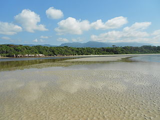
The Ilha Grande mangroves ecoregion covers a series of disconnected salt-water and brackish mangrove forests along the southeastern coast of Brazil on the South Atlantic Ocean. The ecoregion is defined as covering the mangroves found between the Paraíba do Sul River in the north to Florianópolis in the south. This coastal region is the most densely population region of Brazil, and many of the mangroves are in close proximity to ports and industrial cities. A number of ecological reserves have been established to protect the high biodiversity of the mangroves, recognizing their importance to migratory birds, and as nursery habitat for juvenile fish, crabs, shrimp, and mollusks.