List of extreme points of Japan

Last updated
Map all coordinates using: OpenStreetMap  
Download coordinates as: KML
Extreme points of Japan marked on the map Extreme points japan map.png
Extreme points of Japan marked on the map

The extreme points of Japan include the coordinates that are farthest north, south, east and west in Japan, and the ones that are at the highest and the lowest elevations in the country. Japan's northernmost point is disputed, because Japan considers it to be on Iturup, an island de facto governed by Russia. The southernmost point is Okinotorishima; the westernmost is Cape Irizaki on Yonaguni Island in Okinawa Prefecture, and the easternmost is Minami Torishima. The highest point in Japan is the summit of Mount Fuji at 3,776.24 m (12,389 ft). At 150 m (492 ft) below sea level, the bottom of Hachinohe mine is the country's lowest point. The surface of Hachirōgata is Japan's lowest natural point at 4 m (13 ft) below sea level. With the exception of Cape Irizaki, the westernmost location of Japan, all other extreme locations are uninhabited.

Contents

Japan extends from 20° to 45° north latitude (Okinotorishima to Benten-jima) and from 122° to 153° east longitude (Yonaguni to Minami Torishima). [1] The coordinates used in this article are sourced from Google Earth, which makes use of the World Geodetic System (WGS) 84.

Extreme points

A monument indicates the northernmost point of Japan at Cape Soya on Hokkaido. The northernmost point of Japan monument in Soya cape.jpg
A monument indicates the northernmost point of Japan at Cape Sōya on Hokkaido.
Cape Irizaki, Japan's westernmost point on Yonaguni Island The-westernmost-monument-yomaguni.jpg
Cape Irizaki, Japan's westernmost point on Yonaguni Island
Japan's easternmost point lies on Minami Torishima in the Pacific Ocean. Aerial-View-Minamitori-Island-1987.jpg
Japan's easternmost point lies on Minami Torishima in the Pacific Ocean.
Japan's southernmost point on Hateruma island Hateruma-minami.jpg
Japan's southernmost point on Hateruma island

The northernmost point that Japan claims lies on the disputed island of Iturup. Japan's claim to the three southernmost islands of the Kuril Islands is disputed by Russia, who de facto controls the islands. This list provides the northernmost point as claimed by Japan as well as the northernmost undisputed point in Japan.

Overall

HeadingLocation Prefecture Bordering entityCoordinates Ref
North
(disputed)
Cape Kamoiwakka Hokkaido Sea of Okhotsk 45°33′26″N148°45′09″E / 45.55722°N 148.75250°E / 45.55722; 148.75250 (Cape Kamoiwakka (Northernmost - disputed)) [2]
North
(undisputed)
Benten-jima Hokkaidō La Pérouse Strait 45°31′38″N141°55′06″E / 45.52722°N 141.91833°E / 45.52722; 141.91833 (Bentenjima (Northernmost - undisputed)) [3]
South Okinotorishima Tokyo Philippine Sea 20°25′31″N136°04′11″E / 20.42528°N 136.06972°E / 20.42528; 136.06972 (Okinotorishima (Southernmost))
East Minami Torishima Tokyo Pacific Ocean 24°16′59″N153°59′11″E / 24.28306°N 153.98639°E / 24.28306; 153.98639 (Minami Torishima (Easternmost))
West Yonaguni Okinawa East China Sea 24°26′58″N122°56′01″E / 24.44944°N 122.93361°E / 24.44944; 122.93361 ((Westernmost)) Monument of Japan the Westernmost

Five main islands

The five main islands of Japan are Honshū, Hokkaidō, Shikoku, Kyūshū and Okinawa. [4] All of these points are accessible to the public.

HeadingLocation Prefecture Bordering entityCoordinates Ref
North Cape Sōya Hokkaidō La Pérouse Strait 45°31′22″N141°56′11″E / 45.52278°N 141.93639°E / 45.52278; 141.93639 (Cape Sōya)
South Cape Takanasaki Okinawa East China Sea 26°04′30″N127°40′51″E / 26.07500°N 127.68083°E / 26.07500; 127.68083 (Cape Arasaki)
East Cape Nosappu Hokkaidō Pacific Ocean 43°23′06″N145°49′03″E / 43.38500°N 145.81750°E / 43.38500; 145.81750 (Cape Nosappu)
West Cape Irizaki Okinawa East China Sea 26°11′55″N127°38′11″E / 26.19861°N 127.63639°E / 26.19861; 127.63639 (Cape Oominezaki)

Hokkaidō

HeadingLocation Prefecture Bordering entityCoordinates Ref
North Cape Sōya Hokkaidō La Pérouse Strait 45°31′22″N141°56′11″E / 45.52278°N 141.93639°E / 45.52278; 141.93639 (Cape Sōya)
South Cape Shirakami Hokkaidō Tsugaru Strait 41°23′51″N140°11′51″E / 41.39750°N 140.19750°E / 41.39750; 140.19750 (Cape Shirakami)
East Cape Nosappu Hokkaidō Pacific Ocean 43°23′06″N145°49′03″E / 43.38500°N 145.81750°E / 43.38500; 145.81750 (Cape Nosappu)
West Cape Obana Hokkaidō Sea of Japan 42°18′11″N139°46′01″E / 42.30306°N 139.76694°E / 42.30306; 139.76694 (Cape Obana)

Honshū

Northernmost point
Southernmost point
Westernmost point
Easternmost point

Shikoku

HeadingLocation Prefecture Bordering entityCoordinates Ref
NorthCape Takei Kagawa Bungo Channel 34°24′01″N134°08′12″E / 34.40028°N 134.13667°E / 34.40028; 134.13667 (Cape Takei)
South Cape Ashizuri Kōchi Philippine Sea 32°43′19″N133°00′19″E / 32.72194°N 133.00528°E / 32.72194; 133.00528 (Cape Ashizuri)
EastCape Gamōda Tokushima Kii Channel 33°50′03″N134°45′00″E / 33.83417°N 134.75000°E / 33.83417; 134.75000 (Cape Gamōda)
WestCape Sada Ehime Hōyo Strait 33°20′38″N132°00′45″E / 33.34389°N 132.01250°E / 33.34389; 132.01250 (Cape Sada)

Kyūshū

Northernmost point
Southernmost point
Westernmost point
Easternmost point

Okinawa

Northernmost
Southernmost
Easternmost
Westernmost

Extreme altitudes

The summit of Mount Fuji is the highest point in Japan. MtFuji FujiCity.jpg
The summit of Mount Fuji is the highest point in Japan.
Hachirogata is the lowest natural point in Japan. Oga Peninsula and Hachirogata Akita Japan SRTM.jpg
Hachirogata is the lowest natural point in Japan.
ExtremityNameAltitude Prefecture Coordinates Ref
Highest Mount Fuji 3,776 m (12,388 ft) Yamanashi 35°21′29″N138°43′52″E / 35.35806°N 138.73111°E / 35.35806; 138.73111 (Mount Fuji (Highest)) [5]
Lowest
(man-made)
Hachinohe mine 170 m (558 ft) Aomori 40°27′10″N141°32′16″E / 40.45278°N 141.53778°E / 40.45278; 141.53778 (Hachinohe mine (Lowest - man-made)) [6]
Lowest
(natural)
Hachirōgata 4 m (13 ft) Akita 39°54′50″N140°01′15″E / 39.91389°N 140.02083°E / 39.91389; 140.02083 (Hachirōgata (Lowest - natural)) [5]


See also

Notes

^† Coordinates obtained from Google Earth. Google Earth makes use of the WGS84 geodetic reference system.
^‡ Although Japan claims this island as part of Hokkaido, this territory is disputed and Iturup is currently under Russian administration.

Related Research Articles

<span class="mw-page-title-main">Yonaguni, Okinawa</span> Town in Kyushu, Japan

Yonaguni is a town located entirely on Yonaguni Island in Yaeyama District, Okinawa Prefecture, Japan. It is the westernmost municipality in Japan, and is known for billfish fishing and as a diving spot. In 1987, divers discovered the Yonaguni Monument, a rock formation that some believe may be man-made.

<span class="mw-page-title-main">Extreme points of Ireland</span>

This is a list of the extreme points of Ireland – the points that are farthest north, south, east or west in Ireland. It includes the Republic of Ireland and Northern Ireland.

This is a list of the extreme points of Europe: the geographical points that are higher or farther north, south, east or west than any other location in Europe. Some of these positions are open to debate, as the definition of Europe is diverse.

This is a list of the extreme points of Asia, the points that are farther north, south, east or west than any other location on the continent.

The extreme points of Norway include the coordinates that are farther north, south, east or west than any other location in Norway; and the highest and the lowest altitudes in the country. The northernmost point is Rossøya on Svalbard, the southernmost is Pysen in Mandal, the easternmost is Kræmerpynten on Svalbard, and the westernmost is Hoybergodden on Jan Mayen. The highest peak is Galdhøpiggen, standing at 2,469 m (8,100 ft) above mean sea level, while the lowest elevation is sea level at the coast.

<span class="mw-page-title-main">Ōsumi Peninsula</span> Peninsula in Kagoshima Prefecture, Japan

The Ōsumi Peninsula projects south from the Japanese island of Kyūshū and includes the southernmost point on the island, Cape Sata. Its east coast lies on the Pacific Ocean, while to the west it faces the Satsuma Peninsula across Kagoshima Bay. Politically it is part of Kagoshima Prefecture. Lava erupted in 1914 by Sakurajima made a land connection with the northwest of the Ōsumi Peninsula.

<span class="mw-page-title-main">Cape Irizaki</span> Westernmost point of Japan, on the island of Yonaguni

Cape Irizaki is the western tip of Yonaguni Island and the westernmost point in Japan. The cape is within the town of Yonaguni, Okinawa.

Torishima, Tori-shima or Tori Shima, is a Japanese toponym or personal surname. Most versions of the name have the meaning Bird Island, with some exceptions.

<span class="mw-page-title-main">Cape Hedo</span> Cape on Okinawa Island, Japan

Cape Hedo, also known as Hedo Point, is the northernmost point on Okinawa Island, located within Kunigami Village. A cape jutting out north from the island, it faces the South China Sea on the west, and the Pacific Ocean on the east. On a particularly clear day, the island of Yoron (Yoronjima) in Kagoshima Prefecture can be seen on the horizon. Yoron Island is located approximately 23 kilometres (14 mi) to the north.

<span class="mw-page-title-main">Territorial disputes of Japan</span>

Japan is currently engaged in several territorial disputes with nearby countries, including Russia, South Korea, North Korea, the People's Republic of China, and the Republic of China (Taiwan).

<span class="mw-page-title-main">Cape Kamoda</span>

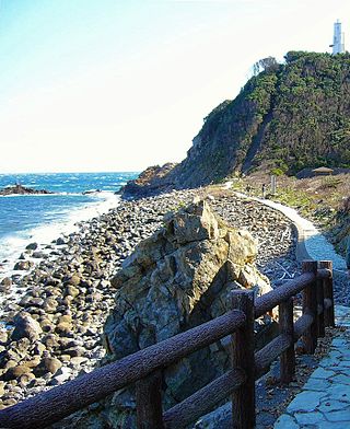
Cape Kamoda is a headland at the easternmost point of the Japanese island of Shikoku, in the city of Anan, Tokushima Prefecture. The promontory extends into the Kii Channel and is situated within Muroto-Anan Kaigan Quasi-National Park. Above the cape is Cape Kamoda Lighthouse, which started operating in 1924; from its observatory it is possible to see Cape Hi in Wakayama Prefecture, Ōnaruto Bridge, and Awaji Island. In 2010 a stone sculpture known as "Wave Song" (「波の詩」) was erected nearby. North of the cape lies Maiko Island, while I Island is to the east. The sandy beach to the north is an egg-laying ground for loggerhead sea turtles and has been designated a Prefectural Natural Monument. In late autumn and winter, so-called "Daruma Sunrises" sometime occur, with the sun appearing in the shape of the Greek letter omega Ω.

References

  1. "GeoHack - Geography of Japan". GeoHack. Retrieved October 14, 2018.
  2. "Google Maps (Cape Kamoiwakka)". Google. Retrieved 2009-07-29.
  3. "Google Maps (Bentenjima)". Google. Retrieved 2009-07-29.
  4. "離島とは(島の基礎知識) (what is a remote island?)". MLIT (Ministry of Land, Infrastructure, Transport and Tourism) (in Japanese). Ministry of Land, Infrastructure, Transport and Tourism. 22 August 2015. Archived from the original (website) on 2007-11-13. Retrieved 9 August 2019. MILT classification 6,852 islands(main islands: 5 islands, remote islands: 6,847 islands)
  5. 1 2 "Japan: Geography". The World Factbook . CIA . Retrieved 2009-03-04.
  6. 施設見学ガイド 八戸鉱山株式会社 八戸石灰鉱山(八戸キャニオン). The Information Center for Energy and Environment Education (in Japanese). Retrieved 2016-04-06.