List of glaciers in Iceland

Last updated

List of glaciers in Iceland
Map of larger glacial catchments in Iceland (light grey shading with white outline). Clicking on the map to enlarge it enables mouse over that allows identification of individual catchments.

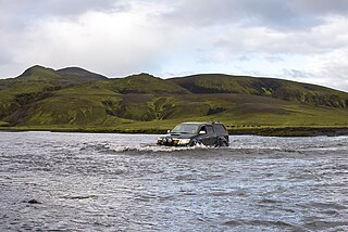
The glaciers and ice caps of Iceland covered 11% of the land area of the country, up to about 2008. As of 2019 this was down to 10%. They have a considerable impact on its landscape and meteorology. Glaciers are also contributing to the Icelandic economy, with a tourist market that includes glacier trips on snowmobiles and glacier hiking tours. However, the recent loss of ice due to climate change is an increasing concern in Icelandic society. [1]

Contents

Description

Glaciers can both grow in size and regress depending upon several factors of which climate and precipitation in the glaciers catchment are the most important. About 7,000 years ago, the Pleistocene ice from the last Ice Age over Iceland disappeared almost entirely, so the current glaciers in Iceland are not that old. [2] :377 In the case of Iceland as several large glaciers are over active volcanoes, geothermal melting can be a substantial component of the glacier ice mass balance. [3] :2 Accordingly Iceland's glacier area varies from year to year and some glaciers may grow while others regress. The tables below have to be interpreted considering such variations in time and do not include much other data that those who study glaciers would regard as important. Data that was gathered over many years in the 1890s, or even by the first complete aerial photographic survey between 1945 and 1946 is difficult to compare to the richer satellite studies and the on the ground measurements possible since the 1990's but such comparisons have been attempted. [3] Even so there are gaps in the data (see Table 2). Two different definitions of a glacier are usually used in current research and much Iceland work is closer to the definition: [3] :7

A perennial mass of ice, and possibly firn and snow, originating on the land surface by the recrystallization of snow or other forms of solid precipitation and showing evidence of past or present flow

An ice cap is a mass of glacial ice that covers less than 50,000 km2 (19,000 sq mi) of land area covering a highland area and they feed outlet glaciers. [4] :52 Many Icelandic ice caps and glaciers lie above volcanoes, such as Grímsvötn and Bárðarbunga, which lie under the largest ice cap, Vatnajökull. The caldera of Grímsvötn is about 100 km2 (39 sq mi) in area, and Bárðarbunga is about 60 km2 (23 sq mi) meaning a large amount of ice, given mean icecap thickness of about 200 m (660 ft) is at risk of geothermal melting.

When volcanic activity occurs under the glacier, the resulting meltwater can lead to a sudden glacial lake outburst flood, known in Icelandic as a jökulhlaup. However jökulhlaups are more commonly caused by accumulation of meltwater due to geothermal activity underneath the glacier. Jökulhlaups occasionally trigger volcanic eruptions through the sudden release of pressure. These eruptions occur towards the end of the Jökulhlaup. [5] :88

The glaciers are relevant enough in Icelandic geography that the four largest are represented blank in most of the maps of the administrative divisions of Iceland smaller than the regions.

Iceland is losing ice due to climate change. In 2008 its glaciers still covered 11% of the land area of the country, at about 11,100 km2 (4,300 sq mi) out of the total area of 103,125 km2 (39,817 sq mi). [2] :365,368As of 2019 this was down to 10%. [3] :2

Okjökull in Borgarfjörður, West Iceland, has lost its glacier title and is now simply known as Ok, losing the Icelandic word for glacier, jökull , as a suffix. In order to fit the criteria glaciers need to be thick enough to sink and move under their own weight, which any ice remaining of Okjökull can not do. Okjökull is the first Icelandic glacier to lose this title in an official manner, [6] [7] but tens of smaller glaciers have disappeared up to 2019. [3] :27

Largest glaciers by surface area

Table 1: 13 Largest Glaciers
Glacier or Ice Cap Area
km2
Volume
km3
Elevation
m
Coordinates
1 Vatnajökull 8,3003,100 [8] 2,109.6 64°24′N16°48′W / 64.400°N 16.800°W / 64.400; -16.800 (Vatnajökull)
2 Langjökull 953195 [8] 1,360 64°45′N19°59′W / 64.750°N 19.983°W / 64.750; -19.983 (Langjökull)
3 Hofsjökull 925208 [9] 1,765 64°49′N18°49′W / 64.817°N 18.817°W / 64.817; -18.817 (Hofsjökull)
4 Mýrdalsjökull 596140 [10] 1,493 63°40′N19°06′W / 63.667°N 19.100°W / 63.667; -19.100 (Mýrdalsjökull)
5 Drangajökull 160 925 66°09′N22°15′W / 66.150°N 22.250°W / 66.150; -22.250 (Drangajökull)
6 Eyjafjallajökull 78 1,666 63°38′N19°36′W / 63.633°N 19.600°W / 63.633; -19.600 (Eyjafjallajökull)
7 Tungnafellsjökull 48 1,535 64°45′N17°55′W / 64.750°N 17.917°W / 64.750; -17.917 (Tungnafellsjökull)
8 Þórisjökull 32 1,350 64°32′31″N20°42′56″W / 64.54194°N 20.71556°W / 64.54194; -20.71556 (Þórisjökull)
9 Eiríksjökull 22 1,672 64°46′24″N20°24′34″W / 64.77333°N 20.40944°W / 64.77333; -20.40944 (Eiríksjökull)
10 Þrándarjökull 22 1,236 64°42′08″N14°54′09″W / 64.70222°N 14.90250°W / 64.70222; -14.90250 (Þrándarjökull)
11 Tindfjallajökull 19 1,462 63°48′N19°35′W / 63.800°N 19.583°W / 63.800; -19.583 (Tindfjallajökull)
12 Torfajökull 15 1,190 63°53′39″N19°07′37″W / 63.89417°N 19.12694°W / 63.89417; -19.12694 (Torfajökull)
13 Snæfellsjökull 11 1,446 64°48′32″N23°46′16″W / 64.80889°N 23.77111°W / 64.80889; -23.77111 (Snæfellsjökull)

These 13 largest glaciers had, at slightly different times around the year 2000, an aggregate area of 10,863 km2 (4,194 sq mi) (out of about 11,079 km2 (4,278 sq mi) for all glaciers of Iceland). [11] The total glacial area in 2019 was down to 10,400 km2 (4,000 sq mi), and had decreased by more than 2,200 km2 (850 sq mi) since the end of the 19th century. [3] :27

Glaciers

List of glaciers in Iceland
Glacier locations in Iceland as on this page

The list of glaciers below and their characteristics is incomplete. Many of the smaller glaciers that are presently only glacier remnants have not been added to the list. There are for example over 170 glaciers on the Tröllaskagi peninsula, [3] :3 northern Iceland and many have little significance or have regressed. Okjökull is mentioned in the table below although it is no longer recognised as a glacier as it has recent significance by its rate of disappearance of a large glacier due to climate change. In Iceland the recent maximum extent of glaciers occurred in a process from the onset of the Little Ice Age about 1450 CE and did not stop until about 1900 CE. [3] :1 Some outlet glaciers have shown marked surges over relatively short periods of time resulting in growth in glacial size. [3] :4 This has only changed the recent overall trend to smaller total area of glacial ice for a brief period in 1963–1964 from a surge in Brúarjökull. [3] :25 Other glaciers have been linked, for example in the 1980s Mýrdalsjökull and Eyjafjallajökull were one continuous ice cap. [12]

Table 2: Selected Iceland Glaciers
NameAlternative Names (italics if historic) [13] Glacier typeArea in 1945 – 1946 (km2) [3] :Table 2Other area (km2)Other yearArea in 2019 (km2) [3] Loss 2019 from max. area [3] Ice cap groupingRecent surges [2] :377Location [14]
Vatnajökull Austurjökular, Austurjökull, Grímsvatnajökull, Klofakjökullice cap83268086 [11] 2000 [11] 772012 %VatnajökullYes 64°24′N16°48′W / 64.400°N 16.800°W / 64.400; -16.800 (Vatnajökull)
BrúarjökullJökuldalsjökulloutlet glacier1600 [5] :702017 [5] :70VatnajökullYes 64°42′58″N16°09′35″W / 64.716190°N 16.159659°W / 64.716190; -16.159659 (Brúarjökull (Vatnajökull))
EyjabakkajökullFljótsdalsjökulloutlet glacierVatnajökullYes 64°40′43″N15°34′47″W / 64.678645°N 15.579806°W / 64.678645; -15.579806 (Eyjabakkajökull (Vatnajökull))
KverkkvíslarjökullKverkjökulloutlet glacierVatnajökullNo 64°39′59″N15°30′44″W / 64.666375°N 15.512287°W / 64.666375; -15.512287 (Kverkkvíslarjökull (Vatnajökull))
Kvíslarjökulloutlet glacierVatnajökullNo 64°39′49″N15°28′18″W / 64.663538°N 15.471586°W / 64.663538; -15.471586 (Kvíslarjökull (Vatnajökull))
Vesturdalsjökulloutlet glacierVatnajökullNo 64°38′45″N15°21′52″W / 64.645739°N 15.364441°W / 64.645739; -15.364441 (Vesturdalsjökull (Vatnajökull))
Suðurfjallsjökulloutlet glacierVatnajökullNo 64°37′01″N15°17′03″W / 64.617009°N 15.284251°W / 64.617009; -15.284251 (Suðurfjallsjökull (Vatnajökull))
AxarfellsjökullÖxarfellsjökull, Axarfjallsjökull, Axarjökulloutlet glacierVatnajökullNo 64°36′11″N15°15′45″W / 64.603169°N 15.262585°W / 64.603169; -15.262585 (Axarfellsjökull (Vatnajökull))
Norðurtungnajökulloutlet glacier remnantVatnajökullNo 64°34′38″N15°19′34″W / 64.577231°N 15.326020°W / 64.577231; -15.326020 (Norðurtungnajökull (Vatnajökull))
AusturtungnajökullSkyndidalsjökulloutlet glacierVatnajökullNo 64°33′20″N15°20′02″W / 64.555671°N 15.333884°W / 64.555671; -15.333884 (Austurtungnajökull (Vatnajökull))
LambatungnajökullÞórðarjökull, Lambatungujökulloutlet glacierVatnajökullNo 64°31′51″N15°24′20″W / 64.530742°N 15.405656°W / 64.530742; -15.405656 (Lambatungnajökull (Vatnajökull))
HoffellsjökullNorðurfellsjökulloutlet glacierVatnajökullNo 64°27′35″N15°30′59″W / 64.459725°N 15.516329°W / 64.459725; -15.516329 (Hoffellsjökull (Vatnajökull))
Svínafellsjökull (Eastern)outlet glacierVatnajökullNo 64°26′31″N15°30′39″W / 64.442026°N 15.510783°W / 64.442026; -15.510783 (Svínafellsjökull (Eastern Vatnajökull))
Viðborðsjökulloutlet glacierVatnajökullNo 64°26′35″N15°38′27″W / 64.442976°N 15.640820°W / 64.442976; -15.640820 (Viðborðsjökull (Vatnajökull))
FláajökullMýrajöklar, Mýrajökull, Hólmsárjökull, Hólsárjökulloutlet glacierVatnajökullNo 64°21′55″N15°39′08″W / 64.365281°N 15.652337°W / 64.365281; -15.652337 (Fláajökull (Vatnajökull))
HeinabergsjökullEystri-Heinabergsjökull, Heinabergsjökull eystri, Heiðnabergsjökull, Heinabergsjöklar, Heinabergsjökull, Mýrajöklaroutlet glacierVatnajökullNo 64°19′33″N15°50′29″W / 64.325945°N 15.841440°W / 64.325945; -15.841440 (Heinabergsjökull (Vatnajökull))
SkálafellsjökullVestri-Heinabergsjökull, Heinabergsjökull vestri, Heinabergsjökull vestari, Heinabergsjöklar, Heinabergsjökulloutlet glacierVatnajökullNo 64°16′46″N15°54′10″W / 64.279557°N 15.902787°W / 64.279557; -15.902787 (Skálafellsjökull (Vatnajökull))
EyvindstungnajökullSultartungnajökull, Sultartungujökull, Hálsajökulloutlet glacierVatnajökullNo 64°14′55″N15°48′13″W / 64.248730°N 15.803664°W / 64.248730; -15.803664 (Eyvindstungnajökull (Vatnajökull))
Birnudalsjökulloutlet glacier remnantVatnajökullNo 64°14′34″N15°55′14″W / 64.242884°N 15.920688°W / 64.242884; -15.920688 (Birnudalsjökull (Vatnajökull))
Breiðamerkurjökullice domeVatnajökullYes 64°07′50″N16°21′26″W / 64.130626°N 16.357136°W / 64.130626; -16.357136 (Breiðamerkurjökull (Vatnajökull))
BrókarjökullSteinajökulloutlet glacierVatnajökullNo 64°15′38″N16°08′20″W / 64.260599°N 16.138824°W / 64.260599; -16.138824 (Brókarjökull (Vatnajökull))
FellsárjökullFellsjökull, Bríkurjökull, Þverártindsjökulloutlet glacierVatnajökullNo 64°10′51″N16°09′21″W / 64.180712°N 16.155898°W / 64.180712; -16.155898 (Fellsárjökull (Vatnajökull))
NorðlingalæðarjökullNorðlingalægðarjökullice streamVatnajökullNo 64°07′19″N16°16′03″W / 64.122030°N 16.267561°W / 64.122030; -16.267561 (Norðlingalæðarjökull (Vatnajökull))
Esjufjallajökullice streamVatnajökullNo 64°06′20″N16°20′03″W / 64.105537°N 16.334086°W / 64.105537; -16.334086 (Esjufjallajökull (Vatnajökull))
Mávabyggðajökullice streamVatnajökullNo 64°05′42″N16°23′33″W / 64.094997°N 16.392597°W / 64.094997; -16.392597 (Mávabyggðajökull (Vatnajökull))
Öræfajökull Hnappafellsjökull, Hnappavallajöklar, Hnappavallajökull, Knappafellsjökull, Sandfellsjökull, Jökullice domeÖræfajökull/VatnajökullNo 64°00′55″N16°38′58″W / 64.015245°N 16.649515°W / 64.015245; -16.649515 (Öræfajökull (Vatnajökull))
FjallsjökullÆrfjallsjökull, Hrútárjökull eystri, Eystri Hrútárjökull,Hrútárjökulloutlet glacierÖræfajökull/VatnajökullNo 64°01′51″N16°28′49″W / 64.030868°N 16.480236°W / 64.030868; -16.480236 (Fjallsjökull (Vatnajökull))
HrútárjökullHrútárjökull vestri, Hrútárjöklaroutlet glacierÖræfajökull/VatnajökullNo 64°00′25″N16°29′46″W / 64.006949°N 16.496238°W / 64.006949; -16.496238 (Hrútárjökull (Vatnajökull))
BræðrajökullBreidaoutlet glacierÖræfajökull/VatnajökullNo 63°59′02″N16°31′54″W / 63.983864°N 16.531766°W / 63.983864; -16.531766 (Bræðrajökull (Vatnajökull))
Kviarjökulloutlet glacierÖræfajökull/VatnajökullNo 63°57′07″N16°30′36″W / 63.951961°N 16.509975°W / 63.951961; -16.509975 (Kviarjökull (Vatnajökull))
Hólárjökulloutlet glacierÖræfajökull/VatnajökullNo 63°57′08″N16°34′39″W / 63.952146°N 16.577416°W / 63.952146; -16.577416 (Hólárjökull (Vatnajökull))
Stigárjökulloutlet glacierÖræfajökull/VatnajökullNo 63°56′50″N16°37′04″W / 63.947322°N 16.617836°W / 63.947322; -16.617836 (Stigárjökull (Vatnajökull))
Stórhöfðajökulloutlet glacierÖræfajökull/VatnajökullNo 63°56′55″N16°38′43″W / 63.948589°N 16.645326°W / 63.948589; -16.645326 (Stórhöfðajökull (Vatnajökull))
Gljúfursárjökulloutlet glacierÖræfajökull/VatnajökullNo 63°56′43″N16°40′05″W / 63.945290°N 16.668075°W / 63.945290; -16.668075 (Gljúfursárjökull (Vatnajökull))
RótarfjallsjökullRótarfjallsjökull (if combined with Kotárjökull)outlet glacierÖræfajökull/VatnajökullNo 63°57′19″N16°41′57″W / 63.955389°N 16.699114°W / 63.955389; -16.699114 (Rótarfjallsjökull (Vatnajökull))
KotárjökullRótarfjallsjökull (if combined with Rótarfjallsjökull), Flögujökull, Slögujökulloutlet glacierÖræfajökull/VatnajökullNo 63°57′27″N16°43′22″W / 63.957424°N 16.722694°W / 63.957424; -16.722694 (Kotárjökull (Vatnajökull))
VirkisjökullVirkisajökull, Falljökull vestarioutlet glacierÖræfajökull/VatnajökullNo 63°58′44″N16°48′03″W / 63.978921°N 16.800936°W / 63.978921; -16.800936 (Virkisjökull (Vatnajökull))
Falljökulloutlet glacierÖræfajökull/VatnajökullNo 63°58′29″N16°46′42″W / 63.974811°N 16.778269°W / 63.974811; -16.778269 (Falljökull (Vatnajökull))
SvínafellsjökullSvinafellsjökulloutlet glacierÖræfajökull/VatnajökullNo 64°00′57″N16°50′20″W / 64.015732°N 16.838770°W / 64.015732; -16.838770 (Svínafellsjökull (Vatnajökull))
SkaftafellsjökullSkaptafellsjökulloutlet glacierÖræfajökull/VatnajökullNo 64°03′23″N16°53′02″W / 64.056352°N 16.883845°W / 64.056352; -16.883845 (Skaftafellsjökull (Vatnajökull))
Skeiðarárjökulloutlet glacier1380 [5] :702017 [5] :70VatnajökullYes 64°03′59″N17°15′12″W / 64.066275°N 17.253269°W / 64.066275; -17.253269 (Skeiðarárjökull (Vatnajökull))
Grænalónsjökulloutlet glacierVatnajökullNo 64°12′52″N17°30′34″W / 64.214373°N 17.509394°W / 64.214373; -17.509394 (Grænalónsjökull (Vatnajökull))
DjúpárjökullKistufellsjökulloutlet glacierVatnajökullNo 64°11′55″N17°34′14″W / 64.198591°N 17.570690°W / 64.198591; -17.570690 (Djúpárjökull (Vatnajökull))
Beinadalsjökulloutlet glacierVatnajökullNo 64°12′02″N17°37′48″W / 64.200423°N 17.630053°W / 64.200423; -17.630053 (Beinadalsjökull (Vatnajökull))
SíðujökullNyrðri-Skeiðarárjökull, Skeiðarárjökull nyrðrioutlet glacierVatnajökullYes 64°08′55″N17°51′37″W / 64.148534°N 17.860290°W / 64.148534; -17.860290 (Síðujökull (Vatnajökull))
SkaftárjökullSkaptárjökulloutlet glacierVatnajökullNo 64°13′23″N18°02′17″W / 64.223100°N 18.037936°W / 64.223100; -18.037936 (Skaftárjökull (Vatnajökull))
TungnaárjökullTungnaárjökull, Tungnárjöklaroutlet glacierVatnajökullYes 64°19′25″N18°04′58″W / 64.323691°N 18.082795°W / 64.323691; -18.082795 (Tungnaárjökull (Vatnajökull))
Sylgjujökulloutlet glacierVatnajökullYes 64°26′16″N17°57′56″W / 64.437888°N 17.965556°W / 64.437888; -17.965556 (Sylgjujökull (Vatnajökull))
Köldukvíslarjökulloutlet glacierVatnajökullYes 64°34′35″N17°49′56″W / 64.576494°N 17.832260°W / 64.576494; -17.832260 (Köldukvíslarjökull (Vatnajökull))
Bárðarbunga Bardarbunga, Bárđarjökull, Bárdharnúpur, Bárđargnípaice domeVatnajökullNo 64°37′52″N17°30′20″W / 64.631065°N 17.505430°W / 64.631065; -17.505430 (Bárðarbunga (Vatnajökull))
Rjúpnabrekkujökulloutlet glacierVatnajökullNo 64°42′06″N17°31′52″W / 64.701787°N 17.531005°W / 64.701787; -17.531005 (Rjúpnabrekkujökull (Vatnajökull))
DyngjujökullKistufellsjökulloutlet glacier1000 [5] :702017 [5] :70VatnajökullYes 64°45′20″N16°53′03″W / 64.755656°N 16.884035°W / 64.755656; -16.884035 (Dyngjujökull (Vatnajökull))
Kverkjökulloutlet glacierVatnajökullNo 64°42′12″N16°37′42″W / 64.703455°N 16.628337°W / 64.703455; -16.628337 (Kverkjökull (Vatnajökull))
Skarphéðinsjökulloutlet glacierVatnajökullNo 64°39′03″N16°36′23″W / 64.650746°N 16.606291°W / 64.650746; -16.606291 (Skarphéðinsjökull (Vatnajökull))
Langjökull Lángjökull, Langijökullice cap992904 [15] 2007 [15] 83624 %LangjökullYes 64°45′N19°59′W / 64.750°N 19.983°W / 64.750; -19.983 (Langjökull)
Baldjökulloutlet and ice dome glacier100 [15] 2007 [15] LangjökullNo 64°49′05″N19°56′59″W / 64.818061°N 19.949602°W / 64.818061; -19.949602 (Baldjökull (Langjökull))
ÞjófadalajökullFúlukvíslarjökulloutlet glacier24 [15] 2007 [15] LangjökullNo 64°50′52″N19°49′00″W / 64.847746°N 19.816715°W / 64.847746; -19.816715 (Þjófadalajökull (Langjökull))
Leiðarjökulloutlet glacier86 [15] 2007 [15] LangjökullNo 64°47′21″N19°47′05″W / 64.789288°N 19.784789°W / 64.789288; -19.784789 (Leiðarjökull (Langjökull))
Kirkjujökulloutlet glacier23 [15] 2007 [15] LangjökullNo 64°43′01″N19°52′08″W / 64.716935°N 19.868960°W / 64.716935; -19.868960 (Kirkjujökull (Langjökull))
NorðurjökullNyrðri-Skriðjökull, Nyrðriskriðjökulloutlet glacier62 [15] 2007 [15] LangjökullNo 64°39′51″N19°54′47″W / 64.664110°N 19.913022°W / 64.664110; -19.913022 (Norðurjökull (Langjökull))
SuðurjökullFremri-Skriðjökulloutlet glacier54 [15] 2007 [15] LangjökullYes 64°35′34″N19°58′55″W / 64.592710°N 19.982027°W / 64.592710; -19.982027 (Suðurjökull (Langjökull))
Eystri-HagafellsjökullHagafellsjökull eystri, Hagafellsjökull, Eystri-Hagafellsjökull, Hagavatnsjökull syðrioutlet glacier111 [15] 2007 [15] LangjökullYes 64°31′27″N20°14′28″W / 64.524123°N 20.241120°W / 64.524123; -20.241120 (Vestari-Hagafellsjökull (Langjökull))
Vestari-HagafellsjökullHagafellsjökull vestri, Hagafellsjökull, Vestri-Hagafellsjökull, Skjaldbreiðarjökulloutlet glacier137 [15] 2007 [15] LangjökullYes 64°31′39″N20°25′34″W / 64.527623°N 20.426063°W / 64.527623; -20.426063 (Vestari-Hagafellsjökull (Langjökull))
LónsjökullLónjökulloutlet glacier137 [15] 2007 [15] LangjökullNo 64°34′46″N20°31′30″W / 64.579413°N 20.525066°W / 64.579413; -20.525066 (Lónsjökull (Langjökull))
Geitlandsjökulloutlet glacier13 [15] 2007 [15] LangjökullNo 64°36′04″N20°37′00″W / 64.601113°N 20.616758°W / 64.601113; -20.616758 (Geitlandsjökull (Langjökull))
Svartárjökulloutlet glacier39 [15] 2007 [15] LangjökullNo 64°37′29″N20°33′10″W / 64.624633°N 20.552818°W / 64.624633; -20.552818 (Svartárjökull (Langjökull))
ÞrístapajökullHallmundarjökulloutlet glacier104 [15] 2007 [15] LangjökullYes 64°44′33″N20°10′53″W / 64.742405°N 20.181384°W / 64.742405; -20.181384 (Þrístapajökull (Langjökull))
Hofsjökull Arnarfellsjökullice cap948889 [11] 1999 [11] 81022 %HofsjökullYes 64°49′N18°49′W / 64.817°N 18.817°W / 64.817; -18.817 (Hofsjökull)
Austari-Jökulsárjökulloutlet glacierHofsjökullNo 64°56′23″N18°42′47″W / 64.939788°N 18.713100°W / 64.939788; -18.713100 (Austari-Jökulsárjökull (Hofsjökull))
Álftabrekkujökulloutlet glacierHofsjökullNo 64°52′36″N19°01′41″W / 64.876595°N 19.027947°W / 64.876595; -19.027947 (Álftabrekkujökull (Hofsjökull))
BlautukvíslarjökullBlautkvíslarjökulloutlet glacierHofsjökullNo 64°39′39″N18°55′14″W / 64.660700°N 18.920541°W / 64.660700; -18.920541 (Blautukvíslarjökull (Hofsjökull))
BlágnípujökullBlágnýpujökulloutlet glacierHofsjökullYes 64°45′00″N19°07′42″W / 64.749924°N 19.128285°W / 64.749924; -19.128285 (Blágnípujökull (Hofsjökull))
Blöndujökulloutlet glacierHofsjökullYes 64°47′03″N19°06′07″W / 64.784233°N 19.101822°W / 64.784233; -19.101822 (Blöndujökull (Hofsjökull))
Brattöldujökulloutlet glacierHofsjökullNo 64°42′46″N19°03′12″W / 64.712668°N 19.053390°W / 64.712668; -19.053390 (Brattöldujökull (Hofsjökull))
Háöldujökulloutlet glacierHofsjökullYes 64°50′13″N18°29′22″W / 64.837012°N 18.489312°W / 64.837012; -18.489312 (Háöldujökull (Hofsjökull))
IllviðrajökullIllviðrahnjúkajökulloutlet glacierHofsjökullNo 64°56′32″N18°37′44″W / 64.942262°N 18.628798°W / 64.942262; -18.628798 (Illviðrajökull (Hofsjökull))
KlakksjökullKlakkajökulloutlet glacierHofsjökullNo 64°51′16″N18°30′08″W / 64.854424°N 18.502156°W / 64.854424; -18.502156 (Klakksjökull (Hofsjökull))
Kvíslajökulloutlet glacierHofsjökullYes 64°51′22″N19°07′11″W / 64.855997°N 19.119645°W / 64.855997; -19.119645 (Kvíslajökull (Hofsjökull))
Lambahraunsjökulloutlet glacierHofsjökullNo 64°57′29″N18°52′55″W / 64.958015°N 18.881929°W / 64.958015; -18.881929 (Lambahraunsjökull (Hofsjökull))
Löngukvíslarjökulloutlet glacierHofsjökullNo 64°54′25″N18°30′39″W / 64.906869°N 18.510728°W / 64.906869; -18.510728 (Löngukvíslarjökull (Hofsjökull))
Miklafellsjökulloutlet glacierHofsjökullNo 64°52′21″N18°31′35″W / 64.872626°N 18.526511°W / 64.872626; -18.526511 (Miklafellsjökull (Hofsjökull))
Miklukvíslarjökulloutlet glacierHofsjökullNo 64°40′18″N18°53′42″W / 64.671529°N 18.895048°W / 64.671529; -18.895048 (Miklukvíslarjökull (Hofsjökull))
Múlajökulloutlet glacierHofsjökullYes 64°39′30″N18°41′58″W / 64.658427°N 18.699487°W / 64.658427; -18.699487 (Múlajökull (Hofsjökull))
NauthagajökullÓlafsfellsjökulloutlet glacierHofsjökullNo 64°39′54″N18°46′14″W / 64.665066°N 18.770648°W / 64.665066; -18.770648 (Nauthagajökull (Hofsjökull))
Rótarjökulloutlet glacierHofsjökullNo 64°42′21″N18°41′26″W / 64.705850°N 18.690525°W / 64.705850; -18.690525 (Rótarjökull (Hofsjökull))
SátujökullEystri-Sátujökull, Lambahraunsjöklaroutlet glacierHofsjökullYes 64°56′34″N18°57′11″W / 64.942719°N 18.952919°W / 64.942719; -18.952919 (Sátujökull (Hofsjökull))
Tungufönnoutlet glacierHofsjökullNo 64°52′39″N18°29′13″W / 64.877521°N 18.486907°W / 64.877521; -18.486907 (Tungufönn (Hofsjökull))
Tvífellsjökulloutlet glacierHofsjökullNo 64°57′28″N18°48′50″W / 64.957741°N 18.813858°W / 64.957741; -18.813858 (Tvífellsjökull (Hofsjökull))
Þverfellsjökulloutlet glacierHofsjökullNo 64°42′09″N19°01′35″W / 64.702558°N 19.026399°W / 64.702558; -19.026399 (Þverfellsjökull (Hofsjökull))
Þjórsárjökulloutlet glacierHofsjökullYes 64°45′17″N18°34′44″W / 64.754660°N 18.578787°W / 64.754660; -18.578787 (Þjórsárjökull (Hofsjökull))
Mýrdalsjökull Miđdalsjökull, Mirdalsjökull, Mýdalsjökull,Austrurjökull, Eyjafjallajökull, Höfđabrekkujökull, Höfđajökull, Höfđarjökull, Kötlugjárjökull, Kötlujökull, Sólheimajökull, Austurjökull, Þykkvabæjarjökullice cap652597 [11] 1999 [11] 52029 %MýrdalsjökullYes 63°40′N19°06′W / 63.667°N 19.100°W / 63.667; -19.100 (Mýrdalsjökull)
Entujökulloutlet glacierMýrdalsjökullNo 63°43′19″N19°14′52″W / 63.721896°N 19.247785°W / 63.721896; -19.247785 (Entujökull (Mýrdalsjökull))
Hafursárjökulloutlet glacierMýrdalsjökullNo 63°33′36″N19°06′24″W / 63.560108°N 19.106772°W / 63.560108; -19.106772 (Hafursárjökull (Mýrdalsjökull))
Hrunárjöklaroutlet glacierMýrdalsjökullNo 63°38′23″N19°21′44″W / 63.639713°N 19.362359°W / 63.639713; -19.362359 (Hrunárjöklar (Mýrdalsjökull))
HuldujökullHvítijökulloutlet glacierMýrdalsjökullNo 63°34′07″N18°55′47″W / 63.568617°N 18.929861°W / 63.568617; -18.929861 (Huldujökull (Mýrdalsjökull))
Jökulsárgilsjökulloutlet glacierMýrdalsjökullNo 63°36′00″N19°19′15″W / 63.599961°N 19.320905°W / 63.599961; -19.320905 (Jökulsárgilsjökull (Mýrdalsjökull))
KlifurárjökullKlifandajökull, Klifandijökulloutlet glacierMýrdalsjökullNo 63°32′43″N19°12′51″W / 63.545412°N 19.214065°W / 63.545412; -19.214065 (Klifurárjökull (Mýrdalsjökull))
Krossárjökulloutlet glacierMýrdalsjökullNo 63°40′42″N19°19′19″W / 63.678219°N 19.321833°W / 63.678219; -19.321833 (Krossárjökull (Mýrdalsjökull))
KötlujökullHöfðabrekkujökull ,Kötlufalljökulloutlet glacierMýrdalsjökullNo 63°35′13″N18°51′03″W / 63.586865°N 18.850900°W / 63.586865; -18.850900 (Kötlujökull (Mýrdalsjökull))
Sandfellsjökulloutlet glacierMýrdalsjökullNo 63°40′20″N18°53′37″W / 63.672329°N 18.893662°W / 63.672329; -18.893662 (Sandfellsjökull (Mýrdalsjökull))
SléttjökullMælifellsjökulloutlet glacierMýrdalsjökullYes 63°46′31″N19°05′34″W / 63.775350°N 19.092845°W / 63.775350; -19.092845 (Sléttjökull (Mýrdalsjökull))
Sólheimajökulloutlet glacierMýrdalsjökullNo 63°33′48″N19°17′48″W / 63.563343°N 19.296693°W / 63.563343; -19.296693 (Sólheimajökull (Mýrdalsjökull))
MosakambsjökullThoroddsengletscheroutlet glacierMýrdalsjökullNo 63°32′59″N19°02′38″W / 63.549800°N 19.044024°W / 63.549800; -19.044024 (Mosakambsjökull (Mýrdalsjökull))
Tungnakvíslarjökulloutlet glacierMýrdalsjökullNo 63°39′09″N19°21′34″W / 63.652553°N 19.359430°W / 63.652553; -19.359430 (Tungnakvíslarjökull (Mýrdalsjökull))
Öldufellsjökulloutlet glacierMýrdalsjökullYes 63°44′24″N18°52′58″W / 63.739960°N 18.882730°W / 63.739960; -18.882730 (Öldufellsjökull (Mýrdalsjökull))
Drangajökull ice cap161146 [11] 2004 [11] 13749 %DrangajökullYes 66°09′N22°15′W / 66.150°N 22.250°W / 66.150; -22.250 (Drangajökull) [3]
KaldalónsjökullLónjökulloutlet glacierDrangajökullYes 66°07′17″N22°17′00″W / 66.121291°N 22.283419°W / 66.121291; -22.283419 (Kaldalónsjökull (Drangajökull))
LeirufjarðarjökullLeirujökulloutlet glacierDrangajökullYes 66°11′40″N22°25′03″W / 66.194573°N 22.417515°W / 66.194573; -22.417515 (Leirufjarðarjökull (Drangajökull))
Reykjarfjarðarjökulloutlet glacierDrangajökullYes 66°11′41″N22°10′46″W / 66.194648°N 22.179542°W / 66.194648; -22.179542 (Reykjarfjarðarjökull ([Drangajökull))
Ljótarjökulloutlet glacierDrangajökullNo 66°13′08″N22°15′10″W / 66.218859°N 22.252795°W / 66.218859; -22.252795 (Ljótarjökull (Drangajökull))
Þaralátursjökulloutlet glacierDrangajökullNo 66°12′24″N22°13′07″W / 66.206605°N 22.218649°W / 66.206605; -22.218649 (Þaralátursjökull (Drangajökull))
Jökulbungaice domeDrangajökullNo 66°10′25″N22°17′10″W / 66.173667°N 22.285983°W / 66.173667; -22.285983 (Jökulbunga (Drangajökull))
Eyjafjallajökull Austurjökull, Hájökullice cap8780 [11] 2003 [11] 6643 %EyjafjallajökullNo 63°38′N19°36′W / 63.633°N 19.600°W / 63.633; -19.600 (Eyjafjallajökull) [3]
AkstaðajökullKaplaskarðsjökulloutlet glacierEyjafjallajökullNo 63°38′24″N19°42′12″W / 63.640038°N 19.703251°W / 63.640038; -19.703251 (Akstaðajökull (Eyjafjallajökull))
GígjökullFalljökull , Skriðjökulloutlet glacierEyjafjallajökullNo 63°39′10″N19°36′58″W / 63.652823°N 19.616139°W / 63.652823; -19.616139 (Gígjökull (Eyjafjallajökull))
Hvannárjökulloutlet glacierEyjafjallajökullNo 63°38′25″N19°29′09″W / 63.640361°N 19.485940°W / 63.640361; -19.485940 (Hvannárjökull (Eyjafjallajökull))
Kaldaklifsjökulloutlet glacierEyjafjallajökullNo 63°35′48″N19°32′20″W / 63.596634°N 19.538813°W / 63.596634; -19.538813 (Kaldaklifsjökull (Eyjafjallajökull))
SeljavallajökullTungugilsjökulloutlet glacierEyjafjallajökullNo 63°35′46″N19°36′35″W / 63.596099°N 19.609792°W / 63.596099; -19.609792 (Seljavallajökull (Eyjafjallajökull))
Steinsholtsjökulloutlet glacierEyjafjallajökullNo 63°39′10″N19°33′17″W / 63.652798°N 19.554701°W / 63.652798; -19.554701 (Steinsholtsjökull (Eyjafjallajökull))
Tungnafellsjökull ice cap4038 [11] 2000 [11] 3234 %TungnafellsjökullNo 64°45′N17°55′W / 64.750°N 17.917°W / 64.750; -17.917 (Tungnafellsjökull)
Hagajökull fremriFremri-Hagajökulloutlet glacierTungnafellsjökullNo 64°45′01″N17°58′40″W / 64.750271°N 17.977724°W / 64.750271; -17.977724 (Hagajökull fremri (Tungnafellsjökull))
Hagajökull innriInnri-Hagajökulloutlet glacierTungnafellsjökullNo 64°46′10″N17°56′38″W / 64.769528°N 17.943963°W / 64.769528; -17.943963 (Hagajökull innri (Tungnafellsjökull))
Tungnajökulloutlet glacierTungnafellsjökullNo 64°46′43″N17°53′07″W / 64.778523°N 17.885268°W / 64.778523; -17.885268 (Tungnajökull (Tungnafellsjökull))
Fellsjökulloutlet glacierTungnafellsjökullNo 64°45′51″N17°49′54″W / 64.764128°N 17.831697°W / 64.764128; -17.831697 (Fellsjökull (Tungnafellsjökull))
Kaldagilsjökulloutlet glacierTungnafellsjökullNo 64°43′27″N17°58′09″W / 64.724147°N 17.969097°W / 64.724147; -17.969097 (Kaldagilsjökull (Tungnafellsjökull))
Þórisjökull Thorisdalurjökull, Sudurjöklarglacier3030 [11] 2000 [11] 23.846 %ÞórisjökullNo 64°32′31″N20°42′56″W / 64.54194°N 20.71556°W / 64.54194; -20.71556 (Þórisjökull)
Eiríksjökull BallLjökull,Arnarvatnsjökullice cap25.422 [11] 2000 [11] 20.545 %EiríksjökullNo 64°46′24″N20°24′34″W / 64.77333°N 20.40944°W / 64.77333; -20.40944 (Eiríksjökull)
Brækur eystriEystri Bækur, Eystri-Brækur, Brækur, Brókarjöklaroutlet glacierEiríksjökullNo 64°47′57″N20°23′33″W / 64.799164°N 20.392579°W / 64.799164; -20.392579 (Brækur eystri (Eiríksjökull))
Brækur vestriVestri Bækur, Brækur, Brókarjöklaroutlet glacierEiríksjökullNo 64°47′26″N20°25′49″W / 64.790420°N 20.430220°W / 64.790420; -20.430220 (Brækur vestri (Eiríksjökull))
KlofajökullStórijökulloutlet glacierEiríksjökullNo 64°47′53″N20°21′58″W / 64.798109°N 20.366119°W / 64.798109; -20.366119 (Klofajökull (Eiríksjökull))
Þorvaldsjökulloutlet glacierEiríksjökullNo 64°46′44″N20°20′43″W / 64.778826°N 20.345410°W / 64.778826; -20.345410 (Þorvaldsjökull (Eiríksjökull))
Ögmundarjökulloutlet glacierEiríksjökullNo 64°47′20″N20°21′47″W / 64.788768°N 20.363053°W / 64.788768; -20.363053 (Ögmundarjökull (Eiríksjökull))
Þrándarjökull Thrándarjökull,Miđlandsjökull, Sviđinhornajökullglacier2717 [11] 2000 [11] 14.259 %No 64°42′08″N14°54′09″W / 64.70222°N 14.90250°W / 64.70222; -14.90250 (Þrándarjökull)
Tindfjallajökull Tindafjallajökullglacier16.815 [11] 2000 [11] 12.445 %No 63°48′N19°35′W / 63.800°N 19.583°W / 63.800; -19.583 (Tindfjallajökull)
Snæfellsjökull Snjófellsjökull, Snjófjallsjökull, Jökull, Vesturjökullice cap13.912 [11] 2002 [11] 8.865 %SnæfellsjökullNo 64°48′32″N23°46′16″W / 64.80889°N 23.77111°W / 64.80889; -23.77111 (Snæfellsjökull)
Blágilsjökulloutlet glacierSnæfellsjökullNo 64°49′29″N23°48′07″W / 64.824680°N 23.802064°W / 64.824680; -23.802064 (Blágilsjökull (Snæfellsjökull))
Hólatindajökulloutlet glacierSnæfellsjökullNo 64°47′54″N23°47′54″W / 64.798249°N 23.798206°W / 64.798249; -23.798206 (Hólatindajökull (Snæfellsjökull))
Hyrningsjökulloutlet glacierSnæfellsjökullNo 64°48′50″N23°45′18″W / 64.814018°N 23.754867°W / 64.814018; -23.754867 (Hyrningsjökull (Snæfellsjökull))
Jökulhálsjökulloutlet glacierSnæfellsjökullNo 64°49′11″N23°46′24″W / 64.819627°N 23.773420°W / 64.819627; -23.773420 (Jökulhálsjökull (Snæfellsjökull))
Kvíahnúksjökulloutlet glacierSnæfellsjökullNo 64°47′42″N23°45′51″W / 64.795005°N 23.764250°W / 64.795005; -23.764250 (Kvíahnúksjökull (Snæfellsjökull))
Torfajökull glacier1611 [11] 1999 [11] 8.164 %TorfajökullNo 63°53′39″N19°07′37″W / 63.89417°N 19.12694°W / 63.89417; -19.12694 (Torfajökull)
HrútfellsjökullHrútafellsjökull, Regnbúđajökull, Regnbogajökull, Regnbúđajöklarice cap7.77 [11] 2000 [11] 4.459 %HrútfellsjökullNo 64°44′31″N19°44′17″W / 64.742019°N 19.737955°W / 64.742019; -19.737955 (Hrútfellsjökull)
MiðjökullÞríjökulloutlet glacierHrútfellsjökullNo 64°44′54″N19°42′48″W / 64.748283°N 19.713292°W / 64.748283; -19.713292 (Miðjökull)
Norðvesturjökulloutlet glacierHrútfellsjökullNo 64°45′10″N19°44′58″W / 64.752811°N 19.749425°W / 64.752811; -19.749425 (Norðvesturjökull)
VesturjökullÞríjökulloutlet glacierHrútfellsjökullNo 64°45′05″N19°43′34″W / 64.751358°N 19.726103°W / 64.751358; -19.726103 (Vesturjökull)
BláfellsjökullglacierNo 64°30′30″N19°50′15″W / 64.508452°N 19.837440°W / 64.508452; -19.837440 (Bláfellsjökull)
Hofsjökull EystriHofsjökullglacier7.15 [11] 2000 [11] 3.174 %No 64°36′57″N15°03′02″W / 64.615778°N 15.050621°W / 64.615778; -15.050621 (Hofsjökull Eystri)
Okjökull Okglacier remnant7.44 [11] 2000 [11] 0.0799 %No 64°36′22″N20°52′47″W / 64.606012°N 20.879676°W / 64.606012; -20.879676 (Okjökull)
Kaldaklofsjökullglacier3.91.679 %No 63°53′32″N19°08′20″W / 63.892189°N 19.138959°W / 63.892189; -19.138959 (Kaldaklofsjökull)
Snæfell ice cap5.34.445 %SnæfellNo 64°47′51″N15°33′44″W / 64.797389°N 15.562109°W / 64.797389; -15.562109 (Snæfell)
Ljósurðarjökulloutlet glacierSnæfellNo 64°47′55″N15°34′38″W / 64.798745°N 15.577155°W / 64.798745; -15.577155 (Ljósurðarjökull (Snæfell))
Dökkurðarjökulloutlet glacierSnæfellNo 64°48′11″N15°35′14″W / 64.802959°N 15.587212°W / 64.802959; -15.587212 (Dökkurðarjökull (Snæfell))
Axlarjökulloutlet glacierSnæfellNo 64°47′36″N15°35′27″W / 64.793352°N 15.590935°W / 64.793352; -15.590935 (Axlarjökull (Snæfell))
Sótajökullglacier remnantSnæfellNo 64°47′36″N15°35′27″W / 64.793352°N 15.590935°W / 64.793352; -15.590935 (Sótajökull (Snæfell))
Dimmagilsjökulloutlet glacierSnæfellNo 64°47′34″N15°33′19″W / 64.792775°N 15.555374°W / 64.792775; -15.555374 (Dimmagilsjökull (Snæfell))
Lambadalsskarðsfönnglacier remnantNo 65°55′09″N23°07′59″W / 65.919283°N 23.132946°W / 65.919283; -23.132946 (Lambadalsskarðsfönn)
Móafellsjökullglacier remnantNo 65°52′53″N18°57′10″W / 65.881283°N 18.952700°W / 65.881283; -18.952700 (Móafellsjökull)
Unadalsjökullglacier remnantNo 65°51′22″N18°58′16″W / 65.856049°N 18.971008°W / 65.856049; -18.971008 (Unadalsjökull)
Deildardalsjökullglacier remnantNo 65°49′37″N18°59′58″W / 65.827027°N 18.999510°W / 65.827027; -18.999510 (Deildardalsjökull)
BúrfellsjökullglacierYes 65°49′13″N18°42′30″W / 65.820171°N 18.708362°W / 65.820171; -18.708362 (Búrfellsjökull)
TeigardalsjökullglacierYes 65°49′19″N18°40′48″W / 65.821953°N 18.680073°W / 65.821953; -18.680073 (Teigardalsjökull)
HálsjökullglacierNo 65°51′59″N18°28′10″W / 65.866504°N 18.469381°W / 65.866504; -18.469381 (Hálsjökull)
Vatnsdalsjökullglacier remnantNo 65°31′32″N18°40′06″W / 65.525441°N 18.668367°W / 65.525441; -18.668367 (Vatnsdalsjökull)
Þverárjökullglacier remnantNo 65°46′05″N18°46′42″W / 65.768101°N 18.778406°W / 65.768101; -18.778406 (Þverárjökull)
Tungnahryggsjökullglacier remnantNo 65°40′54″N18°50′31″W / 65.681756°N 18.841809°W / 65.681756; -18.841809 (Tungnahryggsjökull)
GljúfurárjökullglacierNo 65°42′44″N18°39′34″W / 65.712173°N 18.659577°W / 65.712173; -18.659577 (Gljúfurárjökull)
BarkárdalsjökullglacierNo 65°39′18″N18°50′10″W / 65.655128°N 18.836164°W / 65.655128; -18.836164 (Barkárdalsjökull)
MyrkárjökullglacierNo 65°37′12″N18°49′46″W / 65.620002°N 18.829313°W / 65.620002; -18.829313 (Myrkárjökull)
HjaltadalsjökullglacierNo 65°34′28″N18°53′36″W / 65.574454°N 18.893428°W / 65.574454; -18.893428 (Hjaltadalsjökull)
Vindheimajökullglacier remnantNo 65°39′08″N18°17′57″W / 65.652206°N 18.299226°W / 65.652206; -18.299226 (Vindheimajökull)
FossárjökullglacierNo 65°39′13″N18°17′33″W / 65.653556°N 18.292536°W / 65.653556; -18.292536 (Fossárjökull)
HúsárjökullglacierNo 65°38′35″N18°19′18″W / 65.643171°N 18.321543°W / 65.643171; -18.321543 (Húsárjökull)
BægisárjökullglacierYes 65°35′03″N18°22′26″W / 65.584207°N 18.373948°W / 65.584207; -18.373948 (Bægisárjökull)
LambárdalsjökullglacierNo 65°33′56″N18°15′07″W / 65.565624°N 18.252002°W / 65.565624; -18.252002 (Lambárdalsjökull)
Glerárdalsjökullglacier remnantNo 65°33′09″N18°21′30″W / 65.552503°N 18.358396°W / 65.552503; -18.358396 (Glerárdalsjökull)

See also

Related Research Articles

<span class="mw-page-title-main">Geography of Iceland</span> Geographical features of Iceland

Iceland is an island country at the confluence of the North Atlantic and Arctic oceans, east of Greenland and immediately south of the Arctic Circle, atop the constructive boundary of the northern Mid-Atlantic Ridge. The island country is the world's 18th largest in area and one of the most sparsely populated. It is the westernmost European country when not including Greenland and has more land covered by glaciers than continental Europe. Its total size is 103,125 km2 (39,817 sq mi) and possesses an exclusive economic zone of 751,345 km2 (290,096 sq mi).

<span class="mw-page-title-main">Vatnajökull</span> Icelandic glacier

Vatnajökull is the largest and most voluminous ice cap in Iceland, and the second largest in area in Europe after the Severny Island ice cap of Novaya Zemlya. It is in the south-east of the island, covering approximately 10% of the country.

<span class="mw-page-title-main">Langjökull</span> Outlet glacier in Iceland

Langjökull is the second largest ice cap in Iceland, after Vatnajökull. It is situated in the west of the Icelandic interior or Highlands of Iceland and can be seen clearly from Haukadalur. It covers the higher parts of the Langjökull volcanic system.

<span class="mw-page-title-main">Hofsjökull</span> Ice cap and volcano in Iceland

Hofsjökull is the third largest ice cap in Iceland after Vatnajökull and Langjökull and covers the largest active central volcano in the country, which has the same name. It is situated in the west of the Highlands of Iceland and north of the mountain range Kerlingarfjöll, between the two largest glaciers of Iceland.

<span class="mw-page-title-main">Mýrdalsjökull</span> Glacier in Iceland

Mýrdalsjökull is an ice cap in the south of Iceland. It is to the north of Vík í Mýrdal and to the east of the smaller ice cap Eyjafjallajökull. Between these two glaciers is Fimmvörðuháls pass. Its peak reaches 1,493 m (4,898 ft) in height and in the year 1980 it covered an area of approximately 595 km2 (230 sq mi). In 2016 the covered area of Mýrdalsjökull was believed to be 540 km2 (210 sq mi).

<span class="mw-page-title-main">Highlands of Iceland</span>

The Highland or The Central Highland is an area that comprises much of the interior land of Iceland. The Highland is situated above 300–400 meters and is mostly uninhabitable. The soil is primarily volcanic ash, and the terrain consists of basalt mountains and lava fields. Snow covers the Highland from October until the beginning of June. A few oasis-like areas such as Herðubreiðarlindir and Þórsmörk are also found in the Highland. The Highland has many notable natural features and hiking trails.

<span class="mw-page-title-main">Kverkfjöll</span> Volcano in Iceland

Kverkfjöll is a potentially active central volcano, fissure swarm, and associated mountain range situated on the northern border of the glacier Vatnajökull in Iceland.

<span class="mw-page-title-main">Öræfajökull</span> Volcano in south-eastern Iceland

Öræfajökull is an ice-covered volcano in south-east Iceland. The largest active volcano and the highest peak in Iceland at 2,110 metres (6,920 ft), it lies within the Vatnajökull National Park and is covered by part of the glacier.

<span class="mw-page-title-main">Grímsvötn</span> Volcano in Iceland

Grímsvötn is an active volcano with a fissure system located in Vatnajökull National Park, Iceland. The volcano itself is completely subglacial and located under the northwestern side of the Vatnajökull ice cap. The subglacial caldera is at 64°25′N17°20′W, at an elevation of 1,725 m (5,659 ft). Beneath the caldera is the magma chamber of the Grímsvötn volcano.

<span class="mw-page-title-main">Jökulhlaup</span> Type of glacial outburst flood

A jökulhlaup is a type of glacial outburst flood. It is an Icelandic term that has been adopted in glaciological terminology in many languages. It originally referred to the well-known subglacial outburst floods from Vatnajökull, Iceland, which are triggered by geothermal heating and occasionally by a volcanic subglacial eruption, but it is now used to describe any large and abrupt release of water from a subglacial or proglacial lake/reservoir.

<span class="mw-page-title-main">Geology of Iceland</span>

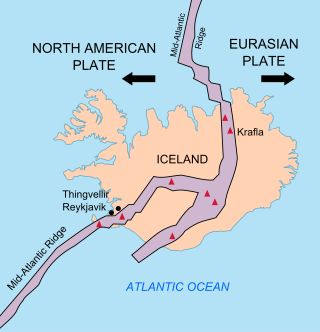
The geology of Iceland is unique and of particular interest to geologists. Iceland lies on the divergent boundary between the Eurasian plate and the North American plate. It also lies above a hotspot, the Iceland plume. The plume is believed to have caused the formation of Iceland itself, the island first appearing over the ocean surface about 16 to 18 million years ago. The result is an island characterized by repeated volcanism and geothermal phenomena such as geysers.

<span class="mw-page-title-main">Esjufjöll</span> Volcano in Iceland

The subglacial Esjufjöll volcano is located in the south-east part of the Vatnajökull icecap. Esjufjöll is a strict nature reserve.

<span class="mw-page-title-main">Torfajökull</span> Volcano in Iceland

Torfajökull is a rhyolitic stratovolcano, with a large caldera capped by a glacier of the same name and associated with a complex of subglacial volcanoes. Torfajökull last erupted in 1477 and consists of the largest area of silicic extrusive rocks in Iceland. This is now known to be due to a VEI 5 eruption 55,000 years ago.

<span class="mw-page-title-main">Tindfjallajökull</span>

Tindfjallajökull is a glacier in the south of Iceland whose name is also given to the underlying stratovolcano. Tindfjöll is a ridge that extends to the south of the glacier and is an alternative name for the volcano. The name of the glacier in Icelandic means "Tindfjöll glacier".

<span class="mw-page-title-main">Tungnafellsjökull</span> Stratovolcano in Iceland

Tungnafellsjökull is a icecap glacier upon a volcano of the same name in Iceland. The volcano is also known as Vonarskarð.

<span class="mw-page-title-main">Thordarhyrna</span>

Thordarhyrna is one of seven subglacial volcanoes beneath the Vatnajokull glacier in Iceland. It is a paired active central volcano with Grímsvötn, and can be classified as part of the Grímsvötn-Laki volcanic system, with common fissure swarms to the south.

<span class="mw-page-title-main">Loki-Fögrufjöll</span>

The Loki-Fögrufjöll is a subglacial volcano under the Vatnajökull glacier.

<span class="mw-page-title-main">1996 eruption of Gjálp</span>

Gjálp is a hyaloclastite ridge (tindar) in Iceland under the Vatnajökull glacier shield. Its present form resulted from an eruption series in 1996 and it is probably part of the Grímsvötn volcanic system. However not all the scientists were of this opinion, as seismic studies are consistent with a 10 km (6.2 mi) lateral dike intrusion at about 5 km (3.1 mi) depth from Bárðarbunga being the trigger event. This does not exclude a shallower secondary intrusion from Grímsvötn being important in the subaerial eruption itself.

<span class="mw-page-title-main">Ice cauldron</span>

Ice cauldrons are ice formations within glaciers that cover some subglacial volcanoes. They can have circular to oblong forms. Their surface areas reach from some meters to up to 1 or more kilometers.

References

  1. "BBC World Service - The Documentary Podcast, Iceland: The great thaw". BBC. Retrieved 2020-01-04.
  2. 1 2 3 Björnsson, H.; Pálsson, F. (2008). "Icelandic glaciers". Jokull. 58 (1): 365–386. doi: 10.33799/jokull2008.58.365 .
  3. 1 2 3 4 5 6 7 8 9 10 11 12 13 14 15 Hannesdóttir, H.; Sigurðsson, O.; Þrastarson, R.H.; Guðmundsson, S.; Belart, J.M.; Pálsson, F.; Magnusson, E.; Víkingsson, S.; Kaldal, I.; Jóhannesson, T. (2020). "A national glacier inventory and variations in glacier extent in Iceland from the Little Ice Age maximum to 2019". Jökull. 12: 1–34. doi: 10.33799/jokull2020.70.001 .
  4. 1 2 Cogley, J. G.; Hock, R.; Rasmussen, L. A.; Arendt, A. A.; Bauder, A.; Braithwaite, R. J.; Jansson, P.; Kaser, G.; Möller, M.; Nicholson, L.; Zemp, M. (2011). Glossary of Glacier Mass Balance and Related Terms. Paris: UNESCO-IHP, IHP-VII Technical Documents in Hydrology No. 86, IACS Contribution No. 2. pp. 1–115. Retrieved 23 May 2024.:45
  5. 1 2 3 4 5 6 7 Baldursson, Snorri; Guðnason, Jónas; Hannesdóttir, Hrafnhildur; Þórðarson, Þorvaldur (2018). Nomination of Vatnajökull National Park dynamic nature of fire and ice for inclusion in the World Heritage List. Reykjavík: Vatnajökull National Park. ISBN   978-9935-9343-3-8.
  6. "Okjökull glacier loses its glacier title due to its declining size". Iceland Magazine. 22 September 2014. Archived from the original on 23 September 2014. Retrieved 24 September 2014.
  7. ""Jökullinn" Ok er ekki lengur jökull" ["Glacier" Ok is no longer a glacier]. www.ruv.is. RÚV. Retrieved 24 September 2014.
  8. 1 2 "Áhrif loftlagsbreytinga á stærð og afrennsli Langjökuls, Hofsjökuls og suður Vatnajökuls" [The impact of climate change on the size and drainage of Langjökull, Hofsjökull and south of Vatnajökull](PDF). Raunvis.hi.is. 2006. Archived from the original (PDF) on 2012-11-08.
  9. "Temporal Variability of Ice Flow on Hofsjokull, Iceland, Observed by ERS SAR Interferometry" (PDF). Earth.esa.int. Retrieved 2013-10-01.
  10. "SP-572 - 2004 Envisat & ERS Symposium" (PDF). Retrieved 2010-04-03.[ dead link ]
  11. 1 2 3 4 5 6 7 8 9 10 11 12 13 14 15 16 17 18 19 20 21 22 23 24 25 26 27 28 29 30 31 Miodońska, Alicja. Assessing evolution of ice caps in Suðurland, Iceland, in years 1986 - 2014, using multispectral satellite imagery: Masters Thesis (Thesis). Lund, Sweden: Lund University. pp. 1–110.:20
  12. Miodońska, Alicja. Assessing evolution of ice caps in Suðurland, Iceland, in years 1986 - 2014, using multispectral satellite imagery:Masters Thesis (Thesis). Lund, Sweden: Lund University. pp. 1–110.:72
  13. Sigurðsson, Oddur; Williams, Richard S. (2008). "Geographic Names of Iceland's Glaciers:Historic and Modern". In Richard S. Williams Jr.; Jane G. Ferrigno (eds.). Satellite Image Atlas of Glaciers of the World series (U.S. Geological Survey Professional Paper 1386-D (PDF). Retrieved 21 May 2024.
  14. "National Land Survey of Iceland-Mapviewer (Kortasja-Landmælingar Íslands)" . Retrieved 22 May 2024.
  15. 1 2 3 4 5 6 7 8 9 10 11 12 13 14 15 16 17 18 19 20 21 22 23 24 25 26 Pope, A.; Willis, I.C.; Palsson, F.; Arnold, N.S.; Rees, W.G.; Björnsson, H.; Grey, L. (2016). "Elevation change, mass balance, dynamics and surging of Langjökull, Iceland from 1997 to 2007". Journal of Glaciology. 62 (233): 497–511. Bibcode:2016JGlac..62..497P. doi:10.1017/jog.2016.55.:503