Iceland is an island country at the confluence of the North Atlantic and Arctic oceans, east of Greenland and immediately south of the Arctic Circle, atop the constructive boundary of the northern Mid-Atlantic Ridge. The island country is the world's 18th largest in area and one of the most sparsely populated. It is the westernmost European country when not including Greenland and has more land covered by glaciers than continental Europe. Its total size is 103,125 km2 (39,817 sq mi) and possesses an exclusive economic zone of 751,345 km2 (290,096 sq mi).

Vatnajökull is the largest and most voluminous ice cap in Iceland, and the second largest in area in Europe after the Severny Island ice cap of Novaya Zemlya. It is in the south-east of the island, covering approximately 10% of the country.

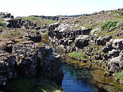
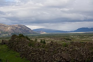
Þingvellir was the site of the Alþing, the annual parliament of Iceland from the year 930 until the last session held at Þingvellir in 1798. Since 1881, the parliament has been located within Alþingishúsið in Reykjavík.

Snæfellsjökull is a 700,000-year-old glacier-capped stratovolcano in western Iceland. It is situated on the westernmost part of the Snæfellsnes peninsula. Sometimes it may be seen from the city of Reykjavík over Faxa Bay, at a distance of 120 km (75 mi).

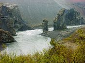
Jökulsá á Fjöllum is the second longest river in Iceland (206 km). Its source is the Vatnajökull glacier. It flows into the Greenland Sea. Jökulsá á Fjöllum streams over the waterfalls Selfoss, Dettifoss, Hafragilsfoss, and Réttarfoss, the second of which is the most powerful waterfall in Europe.

Jökulsárlón is a large glacial lake in southern part of Vatnajökull National Park, Iceland. Situated at the head of the Breiðamerkurjökull glacier, it developed into a lake after the glacier started receding from the edge of the Atlantic Ocean. The lake has grown since then at varying rates because of melting of the glaciers. The glacial front is now about 8 km (5.0 mi) away from the ocean's edge and the lake covers an area of about 18 km2 (6.9 sq mi). In 2009 it was reported to be the deepest lake in Iceland, at over 284 m (932 ft), as glacial retreat extended its boundaries. The size of the lake has increased fourfold since the 1970s.
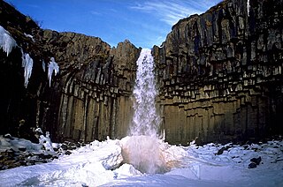
Svartifoss is a waterfall in Skaftafell in Vatnajökull National Park in Iceland, and is one of the most popular sights in the park. It is surrounded by dark lava columns, which gave rise to its name.

Höfn or Höfn í Hornafirði is an Icelandic fishing town in the southeastern part of the country. It lies near Hornafjörður fjord.

Skaftafell is a preservation area in Öræfi, southeast Iceland. It was once a major farm, later being named a national park. Originally known as Skaftafell National Park, it was subsequently joined together with other nearby regions to form the larger Vatnajökull National Park.

The following outline is provided as an overview of and topical guide to Iceland:

Vatnajökull National Park is one of three national parks in Iceland. It encompasses all of Vatnajökull glacier and extensive surrounding areas. These include the national parks previously existing at Skaftafell in the southwest and Jökulsárgljúfur in the north.

Hof, in Öræfi, is a cluster of farms in the municipality of Sveitarfélagið Hornafjörður in southeast Iceland, close to Vatnajökull glacier, and twenty two kilometres south of Skaftafell in Vatnajökull National Park. It is on the Route 1 southwest of Höfn, in the narrow strip between the sea coast and the glacier.

Öræfasveit or Öræfi is a western region in Austur-Skaftafellssýsla, Iceland. It lies between Breiðamerkursandur and the river Skeiðará, east of the village of Kirkjubæjarklaustur and South, West and East of the Öræfajökull volcano. It has been a part of the municipality of Hornafjörður since 1998. In the Middle Ages, this region was called Hérað or Litlahérað, but was deserted in the wake of the 1362 eruption of Öræfajökull and the subsequent flooding of the region. After these events, the region was simply called Öræfi ("wilderness/desolation").

Guðmundur Ingi Guðbrandsson is a member of parliament Alþingi in Iceland and the Minister of Social Affairs and the Labour Market since November 28, 2021. He represents the Left-Green Party. He was Minister for the Environment and Natural Resources from November 30, 2017 to November 28, 2021. He has also served as the CEO of Landvernd, the largest nature conservation and environmental NGO in Iceland, from 2011 to 2017. In 2017 he became the first openly gay man to become an Icelandic Minister.

Rauðhólar (Vesturdalur) is a small chain of volcanoes within the Askja or the Fremrinámur volcanic systems in the north of Iceland.
The Iceland boreal birch forests and alpine tundra ecoregion covers the island of Iceland in the North Atlantic. The island is volcanic in origin with basaltic soils, and the cold northerly climate prevents any significant crop agriculture. Because the island is young and isolated from larger land masses, species biodiversity is relatively low. Forest cover has been reduced to about 1% of the original birch forest by a long history of timber extraction and soil erosion caused by sheep grazing. Blanket bogs are common.