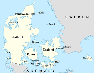
This is a list of islands of Denmark.
This is a list of islands of Denmark.
There are around 1400 islands in Denmark, where about 409 of the islands are named, not including the Faroe Islands or Greenland. [1] Some 70 of them are populated while the rest are uninhabited. Some of the uninhabited islands have only become uninhabited in recent decades, for economic reasons, as lighthouses and other publicly run facilities either became automated, or relocated to main islands or Jutland peninsula. Others became uninhabited as living costs outpaced income for the often fewer than 10 locals.
Different lists of Danish islands vary, depending on how the word "island" is defined. According to the official Danish Government definition, an "island" needs to be surrounded by water at least one-half metre deep, and also to have land vegetation. [2]
Another common criterion is that an "island" needs to be surrounded by free-flowing, natural water and not just an artificial, narrow canal. According to this criterion, places such as Christianshavn and Holmen in Copenhagen, although sometimes referred to as artificial islands, are actually parts of the island of Amager.

The number of islands in Denmark changes from time to time. New islands are occasionally formed by sedimentation. Several examples of these new islands are found in the waters around Æbelø, north of Funen, including Drætlingen which formed in the late 1990s, and a still unnamed islet that was registered in 2008. These new islands are generally less stable than larger, morainic islands, and may later disappear again. Other islands are created artificially. Peberholm, formed in the process of construction of the Øresund Bridge, is a notable example. Other artificial Danish islands include a number of marine fortresses off Copenhagen, such as Middelgrundsfortet, Trekroner Fort and Flakfortet.
Islands may also disappear. An example of this is Jordsand, one of the Danish Wadden Sea Islands. According to records from 1231, the island then had an area of about 2,000 hectares (8 square miles). After a series of severe storms during that century, its area decreased to around 41 hectares, and by 1763 to around 18 hectares. By December 1999, the European windstorm Cyclone Anatol had destroyed the last piece of the island and Jordsand had ceased to exist. [3]
In other cases, islands are absorbed by larger neighbouring masses of dry land, as a result of either natural sedimentation or artificial land reclamation in the channels separating them. Sometimes this means that an island becomes a cape or headland, or a peninsula as is the case of the former island of Reersø.
Denmark's second largest island, the North Jutlandic Island, was not always an island. A storm on 3 February 1825 penetrated the narrow land mass, Agger Tange, and thus separated Northern Jutland from the rest of Jutland. The area had earlier been an island, when a strait at Vust had been open prior to the 12th century.
This is a list of the 100 largest islands of Denmark (press the symbol after the headings in the table to rearrange the list according to population size, location or alphabetically):

Denmark is a Nordic country located in Northern Europe. It consists of the Jutland Peninsula and several islands in the Baltic Sea, referred to as the Danish Archipelago. Denmark is located southwest of Sweden and due south of Norway and is bordered by the German state Schleswig-Holstein to the south, on Denmark's only land border, 68 kilometres long.

Zealand at 7,031 km2 is the largest and most populous island in Denmark proper. Zealand had a population of 2,319,705 on 1 January 2020, comprising 40% of the country's population.

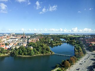
Amager, located in the Øresund, is Denmark's most densely populated island, with more than 216,000 inhabitants. The protected natural area of Naturpark Amager makes up more than one-third of the island's total area of 96 km2.

The Counties of Denmark were former subdivisions of metropolitan Denmark and overseas territories, used primarily for administrative regions, with each county having its own council with substantial powers. Originally there had been twenty-four counties, but the number was reduced to roughly fourteen in 1970 – the number fluctuated slightly over the next three decades. In 2006 there were thirteen traditional counties as well as three municipalities with county status. On 1 January 2007 the counties were abolished and replaced by five larger regions which, unlike the counties, are not municipalities.

Indre By, also known as Copenhagen Center or K or Downtown Copenhagen, is an administrative district (bydel) in central Copenhagen, the capital of Denmark. It covers an area of 4.65 square kilometres (1.80 sq mi), has a population of 26,223, and a population density of 5,638 per km2.

Christianshavn is a neighbourhood in Copenhagen, Denmark. Part of the Indre By District, it is located on several artificial islands between the islands of Zealand and Amager and separated from the rest of the city centre by the Inner Harbour. It was founded in the early 17th century by Christian IV as part of his extension of the fortifications of Copenhagen. Originally, it was laid out as an independent privileged merchant's town with inspiration from Dutch cities but it was soon incorporated into Copenhagen proper. Dominated by canals, it is the part of Copenhagen with the most nautical atmosphere.

The Danish Realm, officially the Kingdom of Denmark, refers to the area over which the monarch of Denmark is head of state. It consists of metropolitan Denmark—the kingdom's territory in continental Europe and sometimes called "Denmark proper" —and the realm's two autonomous regions: the Faroe Islands in the North Atlantic and Greenland in North America. The relationship between the three parts of the Kingdom is also known as The unity of the Realm.

Holmen is a water-bound neighbourhood in Copenhagen, Denmark, occupying the former grounds of the Royal Naval Base and Dockyards. In spite of its name, deceptively in singular, Holmen is a congregation of small islands, forming a north-eastern extension of Christianshavn between Zealand and the northern tip of Amager.
Amager Øst is one of the 10 official districts of Copenhagen Municipality, Denmark. It encompasses the part of Copenhagen located on the island of Amager, east of the major shopping street Amagerbrogade.Prior to an administrative reform in 2006–08, the district was known as Sundbyøster.

The fortifications of Copenhagen underwent a comprehensive modernization and expansion in the 17th century. The project was commenced and was largely the masterplan of Christian IV in the early 17th century but was continued and completed by his successors. The new fortifications relied on the existing, medieval fortifications of the city but the fortified area was extended and a defensive ring around the city completed particularly with new edifices facing the sea. The ring fortification consisted of four bastioned ramparts and an annexed citadel as well as various outworks.
Districts of Copenhagen are often based on informal designations based on historic origins, often with alternative names and loosely defined boundaries. Copenhagen Municipality is divided into 10 official administrative districts but they often comprise areas of a heterogeneous character which are informally not seen as one district. Some districts have earlier been official subdivisions and thus have semi-official boundaries. Copenhagen postal code designations often correspond to district boundaries but in some cases differ from them, as an example parts of the city centre has the postal code København V which is generally associated with Vesterbro.
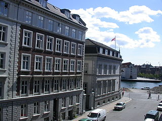
Gammelholm is a predominantly residential neighbourhood in the city centre of Copenhagen, Denmark. It is bounded by the Nyhavn canal, Kongens Nytorv, Holmens Kanal, Niels Juels Gade and the waterfront along Havnegade. For centuries, the area was the site of the Royal Naval Shipyard, known as Bremerholm, but after the naval activities relocated to Nyholm, it came under residential redevelopment in the 1860s and 1870s. The new neighbourhood was planned by Ferdinand Meldahl and has also been referred to as "Meldahl's Nine Streets". Apart from the buildings which face Kongens Nytorv, which include the Royal Danish Theatre and Charlottenborg Palace, the area is characterized by homogeneous Historicist architecture consisting of perimeter blocks with richly decorated house fronts.
Christianshavns Vold is a former rampart which was part of the bastioned fortification ring which used to surround Copenhagen, Denmark. Running along the full south-eastern perimeter of Christianshavn and Holmen, it used to form a protective barrier towards the island of Amager. It consists of earthworks with 12 bastions and in front of it ran a moat, Stadsgraven, now forming a broad canal which separates Christianshavn from the rest of Amager. On the other side of Stadsgraven. on Amager, was a lower system of outworks called Christianshavns Enveloppe of which only the northern half survives. Along with Kastellet on the other side of the harbour, it is the only intact part of the fortification system.
Stadsgraven is the canal which separates Christianshavn from the rest of Amager in Copenhagen, Denmark. It was originally a moat located in front of the Christianshavn Rampart as part of the city's Bastioned Ring Fortifications.

Jacob Fortling was a German-Danish sculptor, architect and industrialist, described as one of the most industrious people in the Denmark of his day. He came to Denmark at age 18 and embarked on a successful career, first as a sculptor and later also as an architect. He was also engaged in the production of building materials, owning several quarries in Norway. Just outside Copenhagen, on Amager's east coast, he founded Kastrup Værk, a large industrial facility combining a lime plant, a brickyard and a pottery.

Jacob Holm was a Danish industrialist, ship owner and merchant. He founded the company Jacob Holm & Sønner, which still exists today.
The Danish language is the official language in Denmark. In the Faroe Islands, the Faroese language and the Danish language are the official languages, and both must be taught in schools. Danish should be used in court, but Faroese can be used in all other official places. The Greenlandic language is the official language in Greenland, and Greenland's Home Rule Act of 2009 does not require Danish to be taught or the use of Danish for official purposes. In accordance with Denmark's official monolingualism, all official documents and communications are in Danish.

(Kongelige) Grønlandske Handels Plads is a waterfront area at the end of Strandgade in the northwestern corner of the Christianshavn neighbourhood of Copenhagen, Denmark. The area is bounded by the Trangraven canal to the north, Christianshavn Canal to the east, Krøyers Plads to the south and the main harbor to the west. The waterfront is also known as Nordatlantens Brygge. It is named for the Royal Greenland Trading Department and was for more than 200 years a hub for Danish trade on Greenland, Iceland and the Faroe Islands. The most notable building is North Atlantic House, an 18th-century warehouse now used as a cultural centre for the North Atlantic area.

Jacob Madsen was a Danish merchant, shipowner and builder with close ties to the crown during the late reign of Christian IV. He was mayor of Christianshavn from 1641 to 1653.
| Baltic Sea | ||
|---|---|---|
| Sydhavsøerne | ||
| Kattegat | ||
| South Funen Archipelago | ||
| Limfjorden | ||
| Øresund | ||
| Great Belt | ||
| Little Belt | ||
| Wadden Sea | ||
| Other islands |
| |
| Sovereign states |
| |
|---|---|---|
| States with limited recognition | ||
| Dependencies and other entities | ||
| Authority control databases: National |
|---|