
The Baltic Sea is an arm of the Atlantic Ocean that is enclosed by Denmark, Estonia, Finland, Germany, Latvia, Lithuania, Poland, Russia, Sweden, and the North and Central European Plain.

Denmark is a Nordic country located in Northern Europe. It consists of the Jutland Peninsula and several islands in the Baltic Sea, referred to as the Danish Archipelago. Denmark is located southwest of Sweden and due south of Norway and is bordered by the German state Schleswig-Holstein to the south, on Denmark's only land border, 68 kilometres long.

Øresund or Öresund, commonly known in English as the Sound, is a strait which forms the Danish–Swedish border, separating Zealand (Denmark) from Scania (Sweden). The strait has a length of 118 kilometres (73 mi); its width varies from 4 kilometres (2.5 mi) to 28 kilometres (17 mi). The narrowest point is between Helsingør in Denmark and Helsingborg in Sweden.
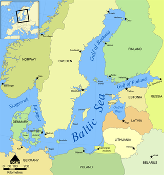
The Gulf of Bothnia is divided into the Bothnian Bay and Bothnian Sea, and it is the northernmost arm of the Baltic Sea, between Finland's west coast and the northern part of Sweden's east coast. In the south of the gulf lies Åland, between the Sea of Åland and the Archipelago Sea.
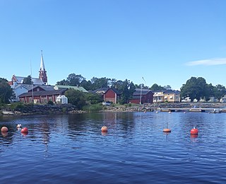
Kristinestad is a town in Finland, located on the west coast of the country. Kristinestad is situated in Ostrobothnia, along the Gulf of Bothnia. The population of Kristinestad is approximately 6,000, while the sub-region has a population of approximately 17,000. It is the 151st most populous municipality in Finland.

Hailuoto is a Finnish island in the northern Baltic Sea and a municipality in Northern Ostrobothnia region. The population of Hailuoto is 948, making it the smallest municipality in Northern Ostrobothnia and the former Oulu Province in terms of population. The municipality covers an area of 205.65 km2 (79.40 sq mi) of which 1.70 km2 (0.66 sq mi) is inland water. The population density is 4.61/km2 (11.9/sq mi). Of all the Finnish sea islands, Hailuoto is the third largest after Fasta Åland and Kimitoön.

Ostrobothnia is a region in western Finland. It borders the regions of Central Ostrobothnia, South Ostrobothnia, and Satakunta. It is one of four regions considered modern-day Ostrobothnia, hence it is also referred to as Coastal Ostrobothnia to avoid confusion.

Kvarken is the narrow region of the Gulf of Bothnia separating the Bothnian Bay from the Bothnian Sea. The distance from the Swedish mainland to the Finnish mainland is around 80 km (50 mi), while the distance between the outermost islands is only 25 km (16 mi). The water depth in the Kvarken region is only around 25 metres (82 ft). The region also has an unusual rate of land rising at almost 10 mm a year.
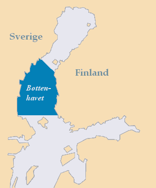
The Bothnian Sea links the Bothnian Bay with the Baltic proper. Kvarken is situated between the two. Together, the Bothnian Sea and Bay make up a larger geographical entity, the Gulf of Bothnia, where the Bothnian Sea is the southern part. The whole Gulf of Bothnia is situated between Sweden, to the west, Finland, to the east, and the Sea of Åland and Archipelago Sea to the south. The surface area of the Bothnian Sea is approximately 79,000 square kilometres (30,500 sq mi). The largest coastal towns, from south to north, are Rauma and Pori in Finland, and Gävle and Sundsvall in Sweden. Umeå (Sweden) and Vaasa (Finland) lie in the extreme north, near Bothnian Bay.

Bothnian Bay National Park is a national park in Lapland, Finland. The park which was established in 1991, covers 157 square kilometres (61 sq mi) of which 2.5 square kilometres (0.97 sq mi) is on land. It is maintained by Metsähallitus.

The Bothnian Bay or Bay of Bothnia is the northernmost part of the Gulf of Bothnia, which is in turn the northern part of the Baltic Sea. The land holding the bay is still rising after the weight of ice-age glaciers has been removed, and within 2,000 years the bay will be a large freshwater lake since its link to the south Kvarken is mostly less than 20 metres (66 ft) deep. The bay today is fed by several large rivers, and is relatively unaffected by tides, so has low salinity. It freezes over each year for up to six months. Compared to other parts of the Baltic, it has little plant or animal life.
Töre is a locality situated in Kalix Municipality, Norrbotten County, Sweden with 1,099 inhabitants as of 2010.

The Åland Sea is a waterway in the southern Gulf of Bothnia, between Åland and Sweden. It connects the Bothnian Sea with the Baltic Sea proper. The western part of the basin is in Swedish territorial waters while the eastern part is in Finnish territorial waters.

Rostojávri (Northern Sami), Råstojaure (Swedish), or Store Rostavatn (Norwegian) is a lake on the border between Norway and Sweden. The Norwegian side of the lake is located in Målselv Municipality in Troms county and the Swedish side of the lake is located in Kiruna Municipality in Norrbotten County. The Norwegian part of the lake lies inside Øvre Dividal National Park. The lake lies at an elevation of 680 metres (2,230 ft) and covers a total area of 34.24 square kilometres (13.22 sq mi); with 3.67 square kilometres (1.42 sq mi) located in Norway and the remaining 30.57 square kilometres (11.80 sq mi) are located in Sweden.
Bothnia or Bothnian may refer to:
The Finland–Sweden border is the border between the countries of Finland and Sweden. Almost the entire border runs through water: along the Tornio River and its tributaries, and in the Gulf of Bothnia. Only a few kilometres of the border are on dry land. Because of the Schengen treaty and the Nordic Passport Union, the border can be crossed mostly freely.
The Norrbotten archipelago is a group of Swedish islands in the north part of the Bay of Bothnia. A few of the islands have small permanent populations, but most are used only for recreation in the summer months. They are icebound during the winter.

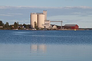
Säppi Lighthouse is a lighthouse on the coast of Bothnian Sea, located outside the city of Pori in the island of Säppi. The lighthouse stands approximately 14 kilometers Southwest of the Port of Pori on the area of Eurajoki municipality. It was designed by Finnish architect Axel Hampus Dalström and first lit in 1873.