The following is a sortable list of the mountains and hills of Malaysia .
The following is a sortable list of the mountains and hills of Malaysia .
{{row numbers|
| Rank | Name | Range | State | Height (m) | Height (ft) | Remarks |
|---|---|---|---|---|---|---|
| 1 | Mount Kinabalu | Crocker Mountains | Sabah | 4,095.2 | 13,435.7 | Twenty-eighth highest peak in Southeast Asia. Highest peak in Malaysia and Borneo. 20th most prominent peak in the world. Unique endemic plants and animals. With nice weather, view includes the TAR Marine Park Islands. The only place in Malaysia to have recorded snowfall, since the 1980s. |
| 2 | Mount Trusmadi | Trusmadi Range | Sabah | 2,642 | 8,669 | |
| 3 | Mount Sinsing | Trusmadi Range | Sabah | 2,603 | 8,540 | The New 3rd Highest Peak Record Found |
| 4 | Mount Tambuyukon | Crocker Mountains | Sabah | 2,579 | 8,462 | |
| 5 | Mount Kaingaran | Trusmadi Range | Sabah | 2,468 | 8,097 | The New 5th Highest Peak Record Found |
| 6 | Mount Murud | Tama Abu Range | Sarawak | 2,424 | 7,946 | Highest peak in Sarawak. |
| 7 | Mount Mulu | Tama Abu Range | Sarawak | 2,376 | 7,795 | Has unique rock formations called The Pinnacles. |
| 8 | Mount Tahan | Tahan Range | Pahang-Kelantan border | 2,187 | 7,175 | Highest peak in Peninsular Malaysia and Pahang. Unique plants and animals. One of Peninsular Malaysia's seven tallest mountains above 2,100 m (6,890 ft), known as the G7 among hikers. |
| 9 | Mount Korbu | Titiwangsa Mountains | Perak | 2,183 | 7,162 | Highest peak in Perak and the whole Titiwangsa Range, second tallest mountain in Peninsular Malaysia after Mount Tahan. |
| 10 | Mount Yong Belar | Titiwangsa Mountains | Kelantan-Perak border | 2,181 | 7,156 | Highest peak in Kelantan. |
| 11 | Mount Gayong | Titiwangsa Mountains | Perak | 2,173 | 7,129 | |
| 12 | Mount Chamah | Titiwangsa Mountains | Kelantan | 2,171 | 7,123 | |
| 13 | Mount Yong Yap | Titiwangsa Mountains | Kelantan-Perak border | 2,168 | 7,113 | |
| 14 | Mount Ulu Sepat | Titiwangsa Mountains | Kelantan-Perak border | 2,161 | 7,090 | |
| 15 | Mount Batu Putih | Titiwangsa Mountains | Perak | 2,131 | 6,990 | |
| 16 | Mount Tama Abu | Tama Abu Range | Sarawak | 2,112 | 6,930 | |
| 17 | Mount Irau | Titiwangsa Mountains | Pahang-Perak border | 2,110 | 6,923 | Easily accessible mossy forest. |
| 18 | Mount Benum | Benom Range | Pahang | 2,107 | 6,914 | |
| 19 | Mount Apad Runan | Tama Abu Range | Sarawak | 2,103 | 6,900 | |
| 20 | Mount Gerah | Titiwangsa Mountains | Kelantan-Perak border | 2,103 | 6,898 | |
| 21 | Mount Junction | Titiwangsa Mountains | Pahang-Perak border | 2,088 | 6,850 | |
| 22 | Batu Buli Hill | Tama Abu Range | Sarawak | 2,082 | 6,823 | |
| 23 | Mount Bilah | Titiwangsa Mountains | Kelantan-Perak border | 2,081 | 6,817 | |
| 24 | Mount Berembun | Titiwangsa Mountains | Pahang | 2,078 | 6,817 | |
| 25 | Mount Bieh | Titiwangsa Mountains | Perak | 2,073 | 6,800 | |
| 26 | Mount Wakid | Crocker Mountains | Sabah | 2,066 | 6,778 | |
| 27 | Mount Gedung | Tahan Range | Pahang | 2,065 | 6,776 | |
| 28 | Batu Lawi Hill | Tama Abu Range | Sarawak | 2,046 | 6,712 | |
| 29 | Mount Berinchang | Titiwangsa Mountains | Pahang-Perak border | 2,031 | 6,663 | |
| 30 | Batu Iran Hill | Iran Mountains | Sarawak | 2,018 | 6,620 | |
| 31 | Mount Tangga | Titiwangsa Mountains | Pahang | 2,014 | 6,609 | |
| 32 | Mount Swettenham | Titiwangsa Mountains | Pahang-Kelantan border | 1,961 | 6,434 | |
| 33 | Mount Shoid | Kelantan | 1,947 | 6,387 | ||
| 34 | Mount Ulu Kerchau | Tahan Range | Pahang | 1,945 | 6,380 | |
| 35 | Mount Liang Timur | Titiwangsa Mountains | Perak-Pahang border | 1,933 | 6,343 | |
| 36 | Mount Liang Barat | Titiwangsa Mountains | Perak | 1,933 | 6,342 | |
| 37 | Mount Berhid | Titiwangsa Mountains | Kelantan-Perak border | 1,931 | 6,335 | |
| 38 | Mount Tumang Batak | Titiwangsa Mountains | Pahang-Perak border | 1,923 | 6,309 | |
| 39 | Mount Challi/Pondok | Titiwangsa Mountains | Kelantan-Perak border | 1,923 | 6,309 | |
| 40 | Mount Siku | Titiwangsa Mountains | Pahang | 1,915 | 6,284 | |
| 41 | Mount Tok Nenek | Titiwangsa Mountains | Perak | 1,904 | 6,248 | Has a unique peak made of rocks. Offers 360 degree view of Titiwangsa Mountains. |
| 42 | Mount Lumaku | Crocker Mountains | Sabah | 1,900 | 6,234 | |
| 43 | Mount Noring | Titiwangsa Mountains | Perak | 1,888 | 6,197 | |
| 44 | Mount Belatok | Titiwangsa Mountains | Perak | 1,883 | 6,176 | |
| 45 | Mount Bintang | Bintang Mountains | Kedah-Perak border | 1,862 | 6,110 | Highest peak in Kedah |
| 46 | Mount Noring Timur | Titiwangsa Mountains | Perak | 1,861 | 6,106 | |
| 47 | Pagon Hill | Brunei-Sarawak border | 1,850 | 6,070 | ||
| 48 | Mount Berembun/Beremban | Titiwangsa Mountains | Pahang | 1,840 | 6,037 | |
| 49 | Mount Basor | Titiwangsa Mountains | Kelantan | 1,840 | 6,038 | |
| 50 | Mount Semangkok | Titiwangsa Mountains | Pahang-Selangor border | 1,830 | 6,004 | Highest peak in Selangor |
| 51 | Mount Tiga Negeri | Titiwangsa Mountains | Pahang-Perak-Kelantan border | 1,802 | 5,912 | The peak situated on the borders of three states. |
| 52 | Mount Inas | Bintang Mountains | Kedah-Perak border | 1,801 | 5,907 | |
| 53 | Mount Suku | Titiwangsa Mountains | Perak | 1,797 | 5,896 | |
| 54 | Lamas Hill | Trusmadi Range | Sabah | 1,797 | 5,896 | |
| 55 | Mount Kerihun | Kapuas Hulu Range | Sarawak-West Kalimantan border | 1,790 | 5,870 | |
| 56 | Monkobo Hill | Crocker Mountains | Sabah | 1,788 | 5,866 | |
| 57 | Mount Lotung | Tama Abu Range | Sabah | 1,781 | 5,843 | |
| 58 | Mount Ulu Kali | Titiwangsa Mountains | Selangor-Pahang border | 1,772 | 5,814 | Located near Genting Highlands |
| 59 | Mount Kuar | Kelantan | 1,771 | 5,813 | ||
| 60 | Mount Bujang | Pahang | 1,771 | 5,812 | ||
| 61 | Mount Lawit | Kapuas Hulu Range | Sarawak-West Kalimantan border | 1,767 | 5,800 | |
| 62 | Mount Rajah | Titiwangsa Mountains | Pahang-Selangor border | 1,683 | 5,522 | |
| 63 | Mount Bubu | Bintang Mountains | Perak | 1,657 | 5,435 | |
| 64 | Mount Ulu Jernih | Bintang Mountains | Perak | 1,577 | 5,173 | |
| 65 | Mount Tangga 15 | Tahan Range | Pahang | 1,539 | 5,049 | |
| 66 | Mount Lawit | Pantai Timur Range | Terengganu | 1,519 | 4,984 | Highest peak in Terengganu. |
| 67 | Mount Tapis | Pantai Timur Range | Pahang | 1,512 | 4,960 | Not usually frequented by hikers. Wild and unspoilt. Many leeches. |
| 68 | Mount Ayam | Titiwangsa Mountains | Kelantan | 1,504 | 4,934 | Peak is one-of-a-kind. Full of bonsai-like Leptospermum sp. |
| 69 | Mount Nuang | Titiwangsa Mountains | Selangor-Pahang border | 1,493 | 4,898 | |
| 70 | Mount Besar Hantu | Titiwangsa Mountains | Negeri Sembilan-Pahang border | 1,462 | 4,797 | Highest peak in Negeri Sembilan |
| 71 | Mount Pangkin | Tahan Range | Pahang | 1,462 | 4,797 | |
| 72 | Gunung Mandi Angin | Pantai Timur Range | Terengganu-Pahang border | 1,460 | 4,790 | |
| 73 | Pine Tree Hill | Titiwangsa Mountains | Pahang-Selangor border | 1,445 | 4,777 | |
| 74 | Mount Bunga Buah | Titiwangsa Mountains | Selangor | 1,430 | 4,690 | |
| 75 | Mount Setong | Titiwangsa Mountains | Kelantan | 1,422 | 4,665 | |
| 76 | Meliau Hill | Crocker Mountains | Sabah | 1,321 | 4,334 | |
| 77 | Mount Ledang | Johor | 1,276 | 4,186 | Highest peak in Johor, historically known as Mount Ophir. | |
| 78 | Bukit Larut | Bintang Mountains | Perak | 1,250 | 4,101 | Initially known as Maxwell Hill in the colonial-era. |
| 79 | Mount Jerai | Kedah | 1,217 | 3,992 | ||
| 80 | Mount Reskit | Tahan Range | Pahang | 1,216 | 3,990 | |
| 81 | Bukit Bokbak | Bintang Mountains | Kedah | 1,199 | 3,933 | |
| 82 | Mount Ginivisan | Trusmadi Range | Sabah | 1,147 | 3,763 | |
| 83 | Tololo Hill | Trusmadi Range | Sabah | 1,145 | 3,757 | |
| 84 | Mount Malasak | Lawas | Sarawak | 1,100 | 3608.924 | |
| 85 | Mount Danum | Sabah | 1,093 | 3,586 | ||
| 86 | Bukit Kutu | Titiwangsa Mountains | Selangor | 1,090 | 3576 | One of popular mountains in Selangor above 1km high. An abandoned colonial-era mansion resides at its peak. |
| 87 | Mount Serudum | Pahang | 1,055 | 3,462 | ||
| 88 | Mount Tebu | Pantai Timur Range | Terengganu | 1,039 | 3,408 | Peak almost similar to Mount Ayam. |
| 89 | Mount Belumut | Johor | 1,010 | 3,313 | ||
| 90 | Mount Gading | Sarawak | 965 | 3,166 | ||
| 91 | Mount Serapi | Sarawak | 911 | 2,989 | ||
| 92 | Mount Silam | Sabah | 884 | 2900 | ||
| 93 | Mount Datuk | Titiwangsa Mountains | Negeri Sembilan | 884 | 2900 | The most defining feature of Mount Datuk is the tor at its summit. On a clear day, hikers can get to see the Strait of Malacca from this point. |
| 94 | Mount Raya | Kedah | 881 | 2,890 | Highest peak in Langkawi | |
| 95 | Mount Chemendung | Johor | 846 | 2,766 | ||
| 96 | Western Hill | Penang | 830 | 2,723 | Highest peak in Penang | |
| 97 | Mount Angsi | Titiwangsa Mountains | Negeri Sembilan | 824 | 2,702 | |
| 98 | Mount Santubong | Sarawak | 810 | 2,657 | ||
| 99 | Mount Tampin | Titiwangsa Mountains | Negeri Sembilan | 764 | 2506 | The southern terminus of Titiwangsa Mountains, and the starting point of Trans-Naning hiking trail, which ends in Mount Datuk to its north. |
| 100 | Mount Perlis | Perlis | 733 | 2,405 | Highest peak in Perlis | |
| 101 | Mount Mat Chinchang | Kedah | 713 | 2,339 | ||
| 102 | Mount Pulai | Johor | 654 | 2,146 | ||
| 103 | Ma'okil Hill | Johor | 585 | 1,913 | ||
| 104 | Rajah Hill | Tahan Range | Pahang | 576 | 1,890 | |
| 105 | Bombalai Hill | Sabah | 531 | 1,742 | Extinct volcano. | |
| 106 | Mount Panti | Johor | 513 | 1,684 | Also known as Gunung Panti, can see a lot of leeches during rainy season. | |
| 107 | Mount Lambak | Johor | 510 | 1,673 | A popular place to train for tougher mountains. | |
| 108 | Mount Mostyn | Sabah | 495 | 1,624 | Extinct volcano. | |
| 109 | Bukit Gapis | Melaka | 480 | 1,574 | Also known as Mount Melaka, it is the highest peak in Melaka | |
| 110 | Mount TTS | TTS Mountains | Kedah | 434.1 | 1,424 | The highest peak in the TTS Mountains range. / 6°17'01"N 100°28'37"E |
| 111 | Banang Hill | Johor | 425 | 1,390 | ||
| 112 | Tukau Hill | Johor | 419 | 1,370 | ||
| 113 | Broga Hill | Titiwangsa Mountains | Selangor | 400 | 1,312 | A beautiful hill near Kuala Lumpur that is covered with cogongrass. |
| 114 | Bukit Tabur Barat | Titiwangsa Mountains | Kuala Lumpur-Selangor border | 396 | 1,300 | A quartz ridge on the north eastern part of Kuala Lumpur. Unique endemic plants on its peaks. |
| 115 | Kupong Hill | Johor | 370 | 1,210 | ||
| 116 | Penggaram Hill | Johor | 367 | 1,200 | ||
| 117 | Belading Hill | Johor | 363 | 1,187 | ||
| 118 | Reban Kambing Hill | Johor | 349 | 1,141 | ||
| 119 | Mount Madai | Sabah | 319 | 1,047 | A popular place in Kunak District. | |
| 120 | Soga Hill | Johor | 276 | 903 | A popular hiking spot in Batu Pahat | |
| 121 | Panorama Hill | Pahang | 271 | 889 | A popular place to view sunrise and sunsets in Kuantan. |

The Malay Peninsula is a peninsula in Mainland Southeast Asia. The landmass runs approximately north–south, and at its terminus, it is the southernmost point of the Asian continental mainland. The area contains Peninsular Malaysia, Southern Thailand, and the southernmost tip of Myanmar (Kawthaung). The island country of Singapore also has historical and cultural ties with the region. The indigenous people of the peninsula are Orang Asli and Malays, an Austronesian people.

Ipoh is the capital city of the Malaysian state of Perak. Located by the Kinta River, it is nearly 200 km (120 mi) north of Kuala Lumpur and 150 km (93 mi) southeast of George Town in neighbouring Penang. As of the 2020 census Ipoh had a population of 759,952, making it the eighth-largest city in Malaysia by population.

Genting Highlands is a hill station located on the peak of Mount Ulu Kali in the Titiwangsa Mountains, central Peninsular Malaysia, at 1800 metres elevation. Located in the state of Pahang, it was established in 1965 by the late Malaysian businessman Lim Goh Tong. The primary tourist attraction is Resorts World Genting, a hill resort where casinos and theme parks are situated and where gambling is permitted. Many of Pahang's skyscrapers can be found here.

The Cameron Highlands is a district in Pahang, Malaysia, occupying an area of 712.18 square kilometres (274.97 sq mi). To the north, its boundary touches that of Kelantan; to the west, it shares part of its border with Perak. Situated at the northwestern tip of Pahang, Cameron Highlands is approximately 90 kilometres (56 mi) east from Ipoh, roughly 200 kilometres (120 mi) north from Kuala Lumpur or about 355 kilometres (221 mi) from Kuantan, the capital of Pahang. It is the smallest municipality in the state.

The Jelebu District is the second largest district in Negeri Sembilan, Malaysia after Jempol, with a population over 40,000. Jelebu borders on the Seremban District to its west and Kuala Pilah District to its south, Jempol District to its southeast, Bentong and Bera Districts, Pahang to its east and Hulu Langat District, Selangor to the north. Jelebu is a suburban district with blossoming semi-agricultural industry. Jelebu is also a parliamentary constituency of the Dewan Rakyat in the Malaysian Parliament. Kuala Klawang is the principal town of the district.
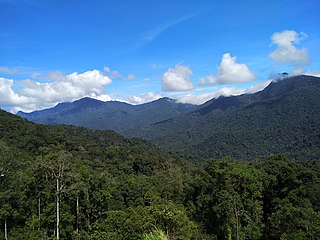
The Titiwangsa Mountains, also known as Banjaran Besar by locals, is the chain of mountains that forms the backbone of the Malay Peninsula. The northern section of the range is in southern Thailand, where it is known as Sankalakhiri Range.

Mount Jerai, formerly Kedah Peak, is a mountain in Kedah, Malaysia with the height of 3,993 feet (1,217 m). Within Kedah itself, the mountain stands at the border of Kuala Muda and Yan districts.

Bukit Larut is a hill resort in Malaysia located in the state of Perak, Malaysia, 10 kilometres southwest from Taiping. It was established under the direction of British colonists in 1884 as a place of observation for tin mining activity and as a retreat for the English people who were based in nearby Larut and Taiping. The area was initially named Maxwell Hill after the British Malaya administrator George Maxwell, and was renamed as Bukit Larut in 1979.

The Jerantut District is a district in north-eastern Pahang, Malaysia. Jerantut is home to the National Park.
Tourism in Malaysia is a major industry and contributor to the Malaysian economy. Malaysia was once ranked 9th in the world for tourist arrivals. The Travel and Tourism Competitiveness Report 2017 ranks Malaysia 25th out of 141 countries overall.
Pagon is the highest mountain in Brunei. It is situated on the border with Malaysia on the island of Borneo. Pagon Hill is located in the Temburong District of Brunei. This district is separated from the rest of Brunei by part of the Sarawak State of Malaysia.
The Tenasserim Hills or Tenasserim Range is the geographical name of a roughly 1,700 km long mountain chain, part of the Indo-Malayan mountain system in Southeast Asia.
A ribu is a mountain that reaches a topographic prominence of at least 1,000 metres (3,281 ft). "Ribu" is a Malay and Indonesian word meaning "thousand".
Mount Benum or Mount Benom is a mountain in the state of Pahang in Malaysia. Its summit is 2,107 m (6,913 ft) above sea level. The mountain is located in a centre of an isolated massif east of the Titiwangsa Mountains.

Raub District is a district in Pahang, Malaysia. Located in the west of the state, the district borders Lipis District to the north, Jerantut District to the east, Temerloh District to the southeast, Bentong District to the south, and the districts of Hulu Selangor and Muallim, respectively situated in the states of Selangor and Perak, to the west. Raub district consists of seven mukim (sub-districts), namely Batu Talam, Sega, Semantan Ulu, Dong, Ulu Dong, Gali and Tras. With an area of 2,271 km², Raub District is sandwiched between the Titiwangsa Mountains and the Benom Massif. Raub District also is home to the hill station of Fraser's Hill. The administrative seat of this district is the town of Raub.
Mount Maria is a volcanic cone mountain located at the Tawau Division of Sabah, Malaysia. It reaches a height of approximately 1,067 metres (3,501 ft).
Mount Magdalena is a volcanic cone mountain located at the Tawau Division of Sabah, Malaysia. It reaches a height of approximately 1,310 metres (4,298 ft).
Mount Lucia is a volcanic cone mountain located at the Tawau Division of Sabah, Malaysia. It reaches a height of approximately 1,201 metres (3,940 ft).
Skull Hill is an archaeological site hill located at Tampi Tampi Road, about 10 kilometres (6.2 mi) south of Semporna town.