List of reference routes in New York

Last updated

Last Northern US 9 Reference Marker.jpg
Last reference marker on NY 971B northbound in Clinton County
Highway names
Interstates Interstate X (I-X)
US Highways U.S. Route X (US X)
State New York State Route X (NY X)
County:County Route X (CR X)
System links

A reference route is an unsigned highway assigned by the New York State Department of Transportation (NYSDOT) to roads that possess a signed name (mainly parkways), that NYSDOT has determined are too minor to have a signed touring route number, or are former touring routes that are still state-maintained. The majority of reference routes are owned by the state of New York and maintained by NYSDOT; however, some exceptions exist. The reference route designations are normally posted on reference markers, small green signs located every tenth-mile on the side of the road, though a few exceptions exist to this practice as well. These designations are not signed like other highways on normal reassurance marker road signs for drivers to see clearly, with four exceptions.

Contents

Reference route numbers are always three digit numbers in the 900s with a single alphabetic suffix. The designations are largely assigned in numerical and alphabetical order within a region, and designations are not reused once they are removed. Certain letters are avoided, such as "I" (used to indicate Interstate Highways and potential confusion with the number 1), "N" (used for institutional roads), "O" (potential confusion with the number 0), "R" (used for reservation roads), "S" (potential confusion with the number 5), "X" (a designation sometimes used in region 10), "Y", and "Z" (at the end of alphabet and not used). "Q" and "U" are not currently being assigned due to confusion in the past. Designations are assigned as follows:

An older system of reference route numbering used numbers ranging from 800 to 999 without an alphabetic suffix. Some reference markers with these older numbers still exist, even though these reference routes have new numbers. Every road maintained by NYSDOT also has a state highway (SH) number, [1] used in state laws. [2]

Region 1

NYSDOT Region 1 primarily covers the Capital District, Saratoga–Champlain and Upper Hudson Valley areas. The counties comprising this region are Albany, Essex, Greene, Rensselaer, Saratoga, Schenectady, Warren, and Washington.

RouteLength
(mi)
Length
(km)
FromViaToNotes
910A 4.036.49 NY 32 (Elm Avenue)Feura Bush and Glenmont roads (SH 367) in Bethlehem NY 144 (River Road)Former routing of NY 32
910B1.923.09 NY 5 (Central Avenue)Wolf Road (SH 69-1) in Colonie Albany CR 151 (Albany Shaker Road), To NY 155/Albany International Airport, and I-87 exits 3&4
910C 0.050.08 Albany city lineBroadway (SH 977) in Menands NY 32 (Wolfert Avenue)Former routing of NY 32
910D 3.305.31 NY 155 (Karner Road) in Albany Washington Avenue Extension (SH 67-15)I-90 eastbound Exit 2 in AlbanyExtended from Fuller Road when that intersection was rebuilt as an interchange
910E 0.921.48 NY 85  / NY 140 New Scotland Road (SH 5237) in Bethlehem Albany city lineFormer number; still shown in the 2017 route log; former routing of NY 85
910F 1.181.90 US 20 (Western Avenue) in Guilderland Fuller Road Alternate (SH 59-8 and SH 57-12) I-87  / I-90 in Albany
910G1.031.66 Albany CR 354  / CR 362 Potter Hollow Road (SH 364) in Rensselaerville NY 81 at NY 145
910H [3] 0.300.48 NY 143 Beckman Road in Westerlo [ citation needed ] NY 32 Former number
910J0.380.61 NY 443 Thacher Park Road (SH 5501) in Berne NY 157A
910K 0.610.98 I-87 exit 29 Blue Ridge Road (SH 8535) in North Hudson US 9
910L 4.116.61 NY 9N  / NY 22 Bridge Road (SH 1796 and SH 9527) in Crown Point Crown Point Bridge at Vermont state line (became Vermont Route 17)Former number; formerly NY 903; now NY 185
910M 0.811.30 John Brown's Grave John Brown Road (SH 1945) in North Elba NY 73
910P0.360.58 US 9W US 9W north ramps (SH 8482) in Catskill NY 23
910U0.190.31 NY 385 Mansion Street Extension (SH 5198) in Coxsackie US 9W Former routing of US 9W
911E 0.210.34 NY 32 (Highland Avenue)Lower Warren Street (SH 656) in Queensbury NY 254 (Quaker Road)
911F 2.233.59Nott Street in Schenectady Erie Boulevard and Freemans Bridge Road (SH 82-20 and SH 1172) NY 50 in Glenville
911G 0.340.55 NY 146  / NY 914T Union Street (SH 1) in Niskayuna NY 7 Formerly NY 950; former routing of NY 7
911H 0.981.58 NY 7 (Curry Road)Altamont Avenue (SH 577B) in Rotterdam Schenectady city lineFormerly NY 951; former routing of NY 7
911P1.913.07 I-87 exit 8Crescent Road (SH 9385) in Halfmoon US 9 Formerly NY 819; previously NY 819 went from CR 47 in Rome via Rabbitt and Old Floyd roads to NY 365 in Floyd
911T0.590.95Pierce RoadUshers Road (SH 9386) in Clifton Park US 9 Formerly NY 822
911U0.871.40 I-87 exit 11 in Malta Round Lake Road (SH 9387) US 9 in Round Lake Former number; Formerly NY 823
911V 0.631.01Austin Acres RoadMohican Trail (SH 613) in Catskill I-87  / Thruway exit 21Continues in both directions as Greene CR 23B
912C 0.080.13 NY 156 Main Street (one block of SH 849) in Altamont NY 146
912E [3] 0.080.13 NY 85A Wye connection (SH 8461) in New Scotland NY 155 Eliminated due to construction of a roundabout
912F0.811.30 US 9  / US 20 Miller Road (SH 9394) in Schodack Reno RoadServes I-90 exit 10
912G0.140.23 US 20 (Madison Avenue)Grand Street (SH 67-1) in Albany Market Street
912M 6.5910.61 I-87  / Thruway in Coeymans Berkshire Connector (SH 56004, SH 56070, SH 56003, and SH 56001) I-90 in Schodack Maintained by the New York State Thruway Authority
912Q 0.651.05 I-87 exit 22Ramp connection (SH 63-6) in Lake George NY 9N Connects I-87 with US 9 and NY 9N
912S 0.600.97 US 9W (McCarty Avenue)Ramp connection (SH 62-4 and SH 62-3) in Albany I-787 exit 1
912T 0.080.13 NY 373 Wye connection (SH 1946) in Chesterfield US 9
912V0.130.21 NY 146 Wye connection (SH 5721) in Clifton Park NY 146A Eliminated in 2019 due to construction of a roundabout
912W 1.322.12 NY 337 (Campbell Road) at I-890 exit 2Rice Road (SH 641 and SH 1853) in Rotterdam I-890 exit 4Former extension of NY 5S
913B0.060.10 NY 85 Wye connection (SH 1280) in Westerlo NY 143
913C0.070.11 NY 157 Wye connection (SH 8244) in New Scotland NY 85
913D0.050.08 NY 157 Wye connection (SH 5724) in Berne NY 157A
913E0.030.05 NY 156 Wye connection (SH 978) in Knox NY 157
913G0.070.11 NY 7 at I-890 exit 9Curry Road (SH 9371) in Guilderland East of I-890
913H0.100.16 US 9W  / NY 32 Wye connection (SH 5499) in Bethlehem NY 32
913J0.080.13 NY 32 Wye connection (SH 9101) in Bethlehem US 9W
913M0.030.05 NY 30 Wye connection (SH 789) in Duanesburg NY 159
913P0.050.08 NY 9P Wye connection (SH 1528) in Stillwater NY 423 Wye replaced by T-intersection before March 2022 [4]
913Q 0.731.17 Mount Van Hoevenberg Bobsled Run Road (SH 67-17) in North Elba NY 73
913T 0.250.40 NY 32 Ramp connection (SH 68-2) in Menands I-787 exit 6
913V 0.781.26 Empire State Plaza South Mall Arterial (SH 74-1, SH 67-2, and SH 67-12) in Albany US 20
914A 0.500.80 NY 22 Moses Road and Main Street (SH 5478) in Petersburg NY 2 Two connecting roads; former routing of NY 2
914B0.400.64 NY 337 (Campbell Road) at I-890 exit 2Campbell Road Extension (SH 70-4) in Rotterdam Old Rice Road
914C1.021.64Washington AvenueRing Road ramps (SH 63-13) in Albany Washington AvenueFormer number; still shown in the 2017 route log.
914D 0.230.37NY 915D (Broadway) at I-890 exit 5Broadway (SH 53-7) in Schenectady Millard Street and Edison Avenue
914E0.250.40Millard StreetVeeder Avenue (SH 63-6) in Schenectady NY 5 (State Street)
914F0.100.16 US 20 Wye connection (SH 439) in Nassau NY 66
914H [5] I-787/NY 7 SH 69-6Arch StreetFormer number; now NY 787
914T 1.943.12 NY 5 Balltown Road (SH 9420) in Niskayuna NY 146  / NY 911G Reference markers show NY 546
914V2.293.69 NY 50 in Glenville Glenridge Road (SH 9421 and SH 9459) NY 146 in Clifton Park
915B 0.380.61Hudson Avenue in Green Island Green Island Bridge (SH 75-77) US 4 in Troy
915C 0.220.35 US 4  / NY 32 (Hudson Avenue) in Stillwater Stillwater Bridge (SH 1791) Rensselaer CR 125 at Canal Road in Schaghticoke Former routing of NY 67
915D 0.160.26NY 914D (Broadway) at I-890 exit 5Broadway (SH 89-2) in Schenectady Weaver Street
915E 1.662.67 NY 151 3rd Avenue Extension (SH 5533) in East Greenbush US 4 Former routing of NY 43
915F0.320.51 I-87 exit 27Vanderwalker Road (SH 65-10) in Schroon US 9
915G 1.191.92 NY 7 Bennington Bypass in Hoosick Vermont state line (becomes Vermont Route 279)
915H 1.392.24 I-87 New York State Thruway (SH 53002) in Albany I-90 Maintained by the New York State Thruway Authority
915J1.772.85NY 911U near I-87 exit 11 in Malta Round Lake Bypass (SH 9387 and SH 2006-3) US 9  / NY 67 in Round Lake Opened 2009
915K0.190.31 US 9  / NY 22 Connector highway in Chesterfield I-87 exit 33Assigned between 2007 and 2009 [6] [7]
915L0.110.18 NY 85 Maher Road (SH 64-13) in Bethlehem NY 910EFormer number; assigned between 2009 and 2012; still shown in the 2017 route log; [7] [8] former routing of NY 85
915M0.470.76 Schenectady CR 69 at Tower AvenueChrisler Avenue (SH 60-9) in Rotterdam I-890  / NY 7 Assigned between 2009 and 2012 [7] [8]
915P0.110.18 I-87 in Warrensburg I-87 exit 24 Warren CR 10 (Schroon River Road) in Warrensburg
915Q US 20 SH 78-3 in Duanesburg NY 7 I-88 exit 24 connection
917A 5.879.45 US 9 Prospect Mountain Veterans Memorial Highway (SH 66-1) in Lake George Prospect Mountain Maintained by the New York State Department of Environmental Conservation

Region 2

Region 2 primarily covers the Central, Mohawk Valley, and south-central Adirondack areas of New York. The counties comprising this region are Fulton, Hamilton, Herkimer, Madison, Montgomery, and Oneida.

RouteLength
(mi)
Length
(km)
FromViaToNotes
920A0.060.10 NY 67 South East Avenue (SH 1375) in Johnstown Johnstown city line
920B 0.140.23 Fulton CR 140 at Yanney RoadSH 620 in Ephratah NY 10 Former routing of NY 10; transferred to Fulton County [9]
920C 0.260.42Oakwood AvenueBriggs Street (SH 52-1) in Johnstown NY 30A
920D0.681.09 NY 29 Harrison Street (SH 544 and SH 56-19) in Johnstown NY 30A
920E [10] 0.771.24 Gloversville city lineEasterly Street in Johnstown Fulton CR 102 / CR 122Ownership transferred to Fulton County; now extended CR 102
920H 0.200.32 NY 30 Bridge Street (SH 362) in Northampton Northville village lineFormer routing of NY 30
920J 2.093.36 Gloversville city lineSaratoga Boulevard and Steele Avenue (SH 1377) in Johnstown NY 29 Former routing of NY 29A
920L [11] Old Route 5 NY 5 Former routing of NY 5
920M [12] 0.831.34 NY 169 Fincks Basin Road NY 169 Former routing of NY 169
920P 2.223.57 NY 30A in Fultonville Riverside Drive (SH 5656A and SH 9467) NY 5S in Glen Former NY 862
920T 0.560.90Midway between Maple and 3rd avenuesMoyer Street (SH 1763) in Canajoharie Montgomery StreetFormerly part of NY 361; former NY 927
920V 2.804.51 NY 365 in Prospect Prospect Street (SH 5345 and SH 5346) NY 12  / NY 28 in Remsen Formerly NY 28B
920W NY 13 Lakeshore Road in Verona NY 13Former number; former routing of NY 13; gap in designation at Verona Beach State Park
921B1.953.14Main Street in New York Mills Burrstone Road (SH 1943 and SH 72-3)Bennett Street in Utica Former routing of NY 31
921C 1.332.14 NY 5S Genesee Street (SH 71-22, SH 65-18, and SH 62-12) in Utica Herkimer RoadFormer routing of NY 5  / NY 8  / NY 12
921D0.721.16 NY 12  / NY 28 Mappa Avenue (SH 931) in Barneveld NY 365 Former routing of NY 12 / NY 28; former NY 921
921E 1.061.71 NY 12 Genesee Street (SH 60-12, SH 250, and SH 5052) in New Hartford Utica city lineFormer routing of NY 5  / NY 12; former NY 922
921F0.821.32 Utica city lineBarnes Avenue (SH 1517) in Marcy Mohawk, Adirondack and Northern Railroad grade crossingFormer number; former NY 923
921G0.130.21 NY 29 Mechanic Street (SH 464) in Salisbury NY 29A Wye connection; former NY 928
921KLakeshore RoadForest Avenue in Verona [ citation needed ]Spencer AvenueFormer number
921P0.120.19 NY 5S John Street (SH 71-22) in Utica Broad Street
921T0.631.01 NY 8 Campion and Oxford roads and Mill Street (SH 66-6) in New Hartford NY 8
921V0.020.03 NY 5 eastboundSchuyler Street in Amsterdam NY 5 westboundFormer number; now part of NY 5
921W2.053.30 Utica city lineFrench Road, Champlin Avenue and Whitesboro Street (SH 9464) in Utica NY 5A
922A1.923.09 NY 69 in Whitesboro Mohawk Street (SH 9463) NY 49 in Marcy
922B0.701.13 NY 5S in German Flatts Washington Street (SH 9468) NY 5  / NY 28 in Herkimer
922C 0.070.11 Oneida CR 13 College Hill Road (SH 1610) in Kirkland NY 233 / NY 412
922E1.242.00 NY 69 in Oriskany River Street (SH 9528) NY 49 in Marcy
926A1.272.04 NY 8  / NY 12 northbound in Utica Horatio Street (SH 8N)NY 8 / NY 12 northbound in Deerfield

Region 3

Region 3 primarily covers the eastern Finger Lakes area. The counties comprising this region are Cayuga, Cortland, Onondaga, Oswego, Seneca, and Tompkins.

RouteLength
(mi)
Length
(km)
FromViaToNotes
930B0.851.37Onondaga StreetWest Street Arterial (SH 62-7) in Syracuse I-690 exit 11
930C0.781.26West Street ArterialSeymour and Adams streets (SH 62-7, SH 53-18, and SH 66-7) in Syracuse I-81 exit 18
930F 0.500.80 Ithaca city lineEast Shore Drive (SH 454) in Ithaca NY 34 Former routing of NY 34
930J0.490.79 US 11 Bear Road (SH 57-7) in North Syracuse South Bay Road
930M 0.761.22 NY 298 in Salina New Court Street (SH 672 and SH 672A) Syracuse city line in DeWitt Former number; formerly part of NY 433; now part of NY 598
930P0.881.42 NY 5 Bridge Street (SH 70-2 and SH 68-4) in DeWitt NY 290
930Q0.651.05 NY 281 Ramp connection (SH 62-13) in Cortlandville I-81 exit 12
930T 2.303.70 NY 5 in Camillus SH 5016, SH 71-3, and SH 54-5 I-690 exit 6 in Geddes Former number; now NY 695
930W 0.180.29 Camillus town lineWest Genesee Street (SH 132) in Geddes NY 5 Former routing of NY 5
931B 0.911.46 NY 297 State Fair Boulevard (SH 9425) in Geddes I-690 exit 6Formerly part of NY 48
931E 0.681.09 NY 326 Half Acre Road (SH 9470) in Aurelius US 20  / NY 5
931F 1.151.85 NY 321 Forward Road (SH 897) in Camillus NY 174 Former routing of NY 321
931G 0.190.31 NY 370 Oswego Street (SH 5274) in Liverpool Onondaga CR 91 at Tulip StreetFormerly part of NY 57
931H0.220.35 US 11 Circle Drive (SH 69-5) in Cicero Culvert east of NY 481 exit 10
931J0.160.26 NY 31 Pardee Road (SH 57-6) in Cicero I-81 exit 30 northbound on-ramp
931K0.180.29 NY 481 southbound on-rampSoule Road (SH 69-5) in Clay NY 31
931L0.260.42 US 11 South State Street (SH 64-7) in Syracuse Brighton Avenue
931M0.210.34Teall AvenueArterial Road (SH 672A) in Salina NY 298
931P0.140.23Ramp to NY 690 southboundSorrell Hill Road (SH 8496) in Van Buren NY 31
936A1.582.54 US 11 in Salina I-81 northbound service road (SH 81IN)East Taft Road in Cicero
936B1.552.49East Taft Road in Cicero I-81 southbound service road (SH 81IS) US 11 in Salina
936C0.901.45 Syracuse east city line I-690 eastbound service road (SH 690IE) in East Syracuse Bridge Street
936D0.871.40Bridge Street I-690 westbound service road (SH 690IW) in East Syracuse Syracuse east city line
936E0.490.79Hiawatha Boulevard I-81 northbound service road (SH 81IN) in Syracuse NY 370 westbound
936F0.801.29Ramp to I-81 southbound I-81 southbound service road (SH 81IS) in Syracuse NY 298 westbound

Region 4

Region 4 primarily covers the western Finger Lakes and Genesee Valley areas. The counties comprising this region are Genesee, Livingston, Monroe, Ontario, Orleans, Wayne, and Wyoming.

RouteLength
(mi)
Length
(km)
FromViaToNotes
940D0.240.39 NY 15A Wye connection (SH 1868) in Mendon West Main Street
940G 1.742.80 NY 252 East River Road (SH 1367) in Brighton Rochester city lineDesignation removed November 26, 2007; [13] now part of Monroe CR 84
940H 1.181.90 Livingston County line (becomes CR 84)River Road (SH 5507) in Wheatland NY 251 Formerly part of NY 35
940J1.622.61 NY 15A in Mendon Monroe Street (SH 575 and SH 1803) NY 65 in Honeoye Falls Designated NY 363 from c.1932 [14] [15] to the late 1950s [16] [17]
940K3.966.37 NY 33 Mount Read Boulevard (SH 57-10, SH 50-5, SH 53-3P, SH 50-4, and SH 53-4P) in Rochester Joanne Drive
940L 2.373.81 NY 33A Howard Road (SH 9350) in Gates NY 31 Formerly part of NY 47
940M2.183.51Lyell AvenueLake Avenue (SH 48-5) in Rochester NY 104
940P 1.031.66 NY 386 Spencerport Expressway (SH 61-7) in Gates I-490 Former number; now part of NY 531
940T 1.822.93 I-490 exit 13 Inner Loop (SH 71-7, SH 70-1, SH 70-2, SH 60-7, SH 63-23, and SH 56-3) in Rochester North Union Street
940U0.881.42 I-490 exit 24West Commercial Street (SH 56-9 and SH 64-7) in East Rochester NY 153
941A1.242.00 NY 18 Latta Road (SH 399) in Greece Rochester city line
941B 0.651.05 Rochester city lineEmpire Boulevard (SH 98) in Irondequoit NY 404 at NY 590 exit 8Formerly part of US 104
941C 0.330.53 Ontario CR 25 Outlet Road in Phelps NY 88 Designation removed c.2004; [18] [19] now part of CR 25
941D 1.141.83 Ontario CR 32 at Hickox RoadBristol Road (SH 187) in Canandaigua NY 21 Designation removed between 2004 and 2007; [6] [18] now part of CR 32
941E 1.141.83 NY 245 SH 203 in Gorham Ontario CR 18 northwest of NY 245Designation removed between 2004 and 2007; [6] [18] now part of CR 18
941F 0.520.84 Ontario CR 24  / CR 29 South Street (SH 662) in Gorham NY 245 Designation removed between 2004 and 2007; [6] [18] now part of CR 24
941G0.470.76 US 20  / NY 5 Pre-Emption Road and Washington Street (SH 333) in Geneva Geneva city lineDesignation removed between 2004 and 2007; [6] [18] Pre-Emption Road portion now part of Ontario CR 6
941H [3] 0.040.06 NY 245 Blodgett Road (SH 662) in Gorham NY 247 Wye connection; designation removed between 2004 and 2007; [6] [18] now Ontario CR 50
941K0.130.21 NY 63 in Geneseo Court Street (SH 49-11)Lower Court in Geneseo
941L 5.669.11Irondequoit Bay OutletLake Road (SH 573) in Webster NY 250 Former extension of NY 18; designation removed November 26, 2007; [13] now part of Monroe CR 1
941M0.220.35 NY 98 Roosevelt Highway (SH 1926) in Carlton NY 18 Wye connection
941P 2.173.49 NY 360 Redman Road (SH 286) in Hamlin Cook RoadFormerly NY 215; designation removed November 26, 2007; [13] now part of Monroe CR 236
941V 2.233.59 Rochester city lineBlossom Road (SH 408) NY 286 in Penfield Formerly NY 286A
942B 0.170.27 NY 441 Washington Street (SH 1337) in Penfield Monroe CR 270 at bridge over Irondequoit Creek Designation removed November 26, 2007; [13] now part of CR 270
942D0.430.69 NY 63 Mary Jemison Drive (SH 49-11) in Geneseo US 20A  / NY 39 Connection for NY 63 south to US 20A / NY 39 east
942G0.510.82 I-490 exit 14Plymouth Avenue (SH 54-15 and SH 52-12) in Rochester Inner Loop
942J [3] 0.020.03 NY 251 Wye connection (SH 8223) in Victor NY 96 Designation removed between 2004 and 2007 [6] [18]
942T 0.140.23Lakeshore DriveSouth Main Street (SH 49-7) in Canandaigua US 20  / NY 5  / NY 21  / NY 332 Former routing of US 20 / NY 5
942W 0.470.76 US 20  / NY 5 West Avenue (SH 5576) in Canandaigua Canandaigua city lineFormer routing of US 20 / NY 5; designation removed between 2004 and 2007 [6] [18]
943A 0.440.71 US 20  / NY 5  / NY 21 Bristol Road (SH 187) in Canandaigua Canandaigua city lineFormer routing of NY 21; designation removed between 2004 and 2007 [6] [18]
943B 1.522.45 NY 31 (Redman Road)West Avenue (SH 5425) in Brockport NY 19 Former routing of NY 31; designation removed November 26, 2007; [13] now Monroe CR 281
943C 1.682.70 NY 65 Calkins Road (SH 497) in Pittsford NY 64 Former extension of NY 253
943E 0.971.56 NY 253 Erie Station Road (SH 1499A) in Henrietta NY 15 Former routing of NY 253
943F 0.350.56 Lake Ontario State Parkway at Lake Avenue in Rochester Colonel Patrick O'Rorke Memorial Bridge Thomas Avenue in Irondequoit Assigned November 26, 2007 [13]
946A1.873.01Clinton Avenue in Rochester NY 104 eastbound service road (SH 104E)Goodman Street in Irondequoit Assigned between 2004 and 2007 [6] [18]
946B2.644.25Culver Road in Irondequoit NY 104 westbound service road (SH 104W)Clinton Avenue in Rochester Assigned between 2004 and 2007 [6] [18]
946C2.273.65Five Mile Line Road NY 104 eastbound service road (SH 104E) in Webster NY 250 Assigned between 2004 and 2007 [6] [18]
946D2.283.67 NY 250 NY 104 westbound service road (SH 104W) in Webster Five Mile Line RoadAssigned between 2004 and 2007 [6] [18]
946E 1.101.77Manitou Road NY 531 eastbound service road (SH 531E) in Gates NY 386 Assigned between 2004 and 2007 [6] [18]
946F 1.101.77 NY 386 NY 531 westbound service road (SH 531W) in Gates Manitou RoadAssigned between 2004 and 2007 [6] [18]
947A 35.0656.42Lakeside Beach Road in Carlton Lake Ontario State Parkway (SH 69-2, SH 70-3, SH 69-1, SH 50-2, SH 49-1, SH 49-2, SH 51-3, SH 52-2, SH 53-5, SH 55-1, SH 58-4, and SH C58-25)Lake Avenue in Rochester Maintained by the New York State Department of Transportation (partially under New York State Office of Parks, Recreation and Historic Preservation jurisdiction)
948A 0.550.89 NY 18 Lakeside Beach Road (SH 69-2) in Carlton Lakeside Beach State Park access roadMaintained by the New York State Office of Parks, Recreation and Historic Preservation

Region 5

Region 5 primarily covers the Niagara Frontier and southwestern New York. The counties comprising this region are Cattaraugus, Chautauqua, Erie, and Niagara.

RouteLength
(mi)
Length
(km)
FromViaToNotes
950A 12.7120.45 Pennsylvania state line in South Valley Brown Run and West Bank Perimeter roads (SH 65-1, SH 67-1, SH 65-2, SH 64-2, and SH 68-1) NY 394 at I-86  / NY 17 exit 17 in Coldspring
950B 0.510.82West State StreetNorth State Street (SH 40-2) in Salamanca NY 353 Former number;[ failed verification ] concurrent with Cattaraugus CR 94 north of Salamanca city line
950C 1.512.43 NY 266 Grand Island Boulevard (SH 9333) in Tonawanda NY 324 Eastbound only. Former routing of NY 324
950D 1.221.96 US 20 Shortman Road (SH 62-8) in Ripley NY 5 Serves I-90  / Thruway exit 61
950E0.320.51 NY 5  / NY 384 Church and Division streets (SH 75-33 and SH 69-8) in Buffalo Elm StreetOverlaps NY 5
950H 2.874.62 I-290 exit 2 in Tonawanda Twin Cities Memorial Highway (SH 63-3, SH 67-23, and SH 67-24)Wheatfield Street in North Tonawanda Former number; now part of NY 425
950J 0.220.35 NY 75 Camp Road (SH 1067) in Hamburg NY 5 Former routing of NY 75
950K 1.562.51 Buffalo city lineNiagara Falls Boulevard (SH 5193) on TonawandaAmherst town line US 62  / NY 324
950M 0.691.11 Buffalo city linePotters Road (SH 9219) in West Seneca NY 240 Former routing of NY 240
950U0.230.37Maryland AvenueHighland Avenue (SH 58-24) in Niagara Falls NY 61
951A 2.804.51 NY 384 in Niagara Falls LaSalle Expressway (SH 68-2, SH 67-15, and SH 67-1)Williams Road in Wheatfield
951B 0.400.64 NY 31 Walnut Street (SH 56-18) in Lockport Pound Street
951C 1.091.75 NY 60  / NY 394 Washington Street (SH 61-10) in Jamestown Fluvanna AvenueDesignation removed; now NY 430
951E0.580.93 US 62 Big Tree Road (SH 1586) in Hamburg US 20  / US 20A
951H0.340.55U.S. Customs PlazaConnector from the customs plaza to I-190 (SH 69-1) in Buffalo I-190
951J0.570.92Massachusetts AvenueRamp connection (SH 69-1) in Buffalo I-190  / Thruway southboundMaintained by New York State Thruway Authority
951K0.260.42 NY 5 eastRamp connection (SH 66-1) in Buffalo I-190  / Thruway northbound
951L0.420.68 I-190  / Thruway northboundRamp connection (SH THUWY and SH 69-1) in Buffalo NY 266
951M1.071.72 Allegany State Park Route 1 at Salamanca city lineParkway Drive (SH 55-11) in Salamanca I-86  / US 219  / NY 17 exit 21
951T 9.4315.18 NY 394 in Coldspring Allegheny Reservoir service road (SH 8328, SH 8308, and SH 54-5) NY 417 in Salamanca Formerly part of NY 17; gap in designation in Red House
951V 2.083.35 NY 16  / NY 400 Olean Road (SH 5317) in Aurora NY 16 at NY 400Former routing of NY 16
952A 3.225.18 Buffalo city lineGenesee Street (SH 1212) in Cheektowaga NY 33 Formerly part of NY 33B
952B 0.090.14 Niagara Scenic Parkway John B. Daly Boulevard (SH 75-5) in Niagara Falls NY 384
952G0.440.71 NY 384 Church Street (SH 75-33 and SH 54-2) in Buffalo I-190  / Thruway exit 7
952H 0.050.08 NY 5 Central Avenue (SH 9240) in Silver Creek US 20 Former routing of NY 5; part of US 20 Truck
952J1.061.71 Erie CR 44 at CR 463 New Armor Duells Road (SH 72-1) in Orchard Park NY 240  / NY 277
952M1.081.74 I-86  / NY 17 exit 16West Main Street (SH 9400) in Randolph NY 394
952P 7.6412.30 Pennsylvania state line in Busti Forest Avenue (SH 9407 and SH 9408) NY 60 in Jamestown
952Q 14.0522.61 Buffalo city line in Cheektowaga Walden Avenue (SH 9411) NY 33 in Alden Longest non-parkway reference route
952T2.253.62 Erie CR 171 at CR 192 Sweet Home Road (SH 82-12 and SH 9409) in Amherst Erie CR 301 at CR 232
952V1.953.14 NY 265  / NY 384 in Wheatfield Williams Road (SH 9431) US 62 in Niagara Falls
952W0.450.72 NY 417 West Five Mile Road (SH 9401) in Allegany I-86  / NY 17 exit 24
953A0.210.34 I-86  / NY 17 exit 15School House Road (SH 66-4) in Randolph NY 394
953B 0.430.69 NY 430 Strunk Road (SH 69-6) in Jamestown I-86  / NY 17 exit 11
953C0.370.60 NY 16 Ramp connection (SH 56-4) in West Seneca NY 400
954D 0.951.53 NY 16 Oak and Elm streets (SH 77-25) in Buffalo NY 33
954E0.490.79Reed StreetBuffalo Street (SH 8010) in Olean I-86  / NY 17 exit 25
954F0.510.82 I-990 exit 1Ramp connector (SH 81-2) in Amherst SUNY Buffalo North Campus
954G 6.139.87 US 20A  / NY 78 in Wales Two Rod Road (SH 9412, SH 5635, and SH 529) NY 354 in Marilla Part is former NY 358
954J 1.732.78 NY 430 Southern Tier Expressway spur (SH 73-7) in Ellery I-86  / NY 17 exit 10Former routing of NY 17
954K 1.111.79 NY 394 McDaniel Avenue and Third Street (SH 86-7 and SH 86-4) in Jamestown NY 60
954L 3.115.01Washington StreetBroadway (SH 86-8 and SH 92-3) in Buffalo Fillmore AvenueFormerly part of NY 130
954M 3.475.58 Lockport city line in Lockport Akron Road (SH 749) NY 93 in Royalton Former routing of NY 93; designation removed October 1, 1998; [20] now CR 142
2017 route log still shows NY 954M as a current route. [21]
954P 0.530.85 Niagara Scenic Parkway Upper Mountain Road (SH 60-2) in Lewiston NY 265
954T 0.570.92 I-86  / US 219  / NY 17 exit 23SH 8018 and SH 8144 in Carrollton NY 417 Former routing of US 219; part of US 219 Business
954V0.851.37NY 384Rainbow Blvd and 1st Street (SH 75-4 and SH 73-4)NY 104
955A 0.190.31 Canada–US border Rainbow Bridge in Niagara Falls NY 384 Maintained by Niagara Falls Bridge Commission
955B 0.190.31 Canada–US border Peace Bridge in Buffalo Peace Bridge customs plazaMaintained by Peace Bridge Authority
955C 0.130.21 Canada–US border Whirlpool Rapids Bridge in Niagara Falls NY 182 Maintained by Niagara Falls Bridge Commission
957A 19.2030.90 LaSalle Expressway in Niagara Falls Niagara Scenic Parkway (SH PKWAY and SH RAMP) NY 18 in Porter Maintained by New York State Parks Department
957B 2.293.69West River RoadSouth Parkway (SH 35-2 and SH 35-1) on Grand Island I-190  / Thruway Maintained by New York State Parks Department
957C 8.4813.65South ParkwayWest River Parkway (SH 49-1 and SH 51-3) on Grand Island I-190  / Thruway Maintained by New York State Parks Department
958A 1.201.93 Niagara Scenic Parkway Spur to Fort Niagara (SH 65-2) in Porter Fort Niagara State Park Maintained by New York State Parks Department

Region 6

Region 6 primarily covers the western and central portions of the Southern Tier. The counties comprising this region are Allegany, Chemung, Schuyler, Steuben, and Yates. Reference routes for Tioga County are also listed here, as Tioga County was in Region 6 until August 2007.

RouteLength
(mi)
Length
(km)
FromViaToNotes
960B0.781.26University StreetNorth Main Street (SH 1654) in Alfred NY 244 Former NY 856
960D Steuben County lineSagetown Road in Southport NY 328 Former number; former routing of NY 328; now Chemung CR 78
960H 0.220.35 NY 96 Mill Street (SH 5471) in Candor NY 96B In Region 9; former routing of NY 96B
960J0.731.17 NY 434 NY 17 exit 65 connection (SH 65-3 and SH 66-3) in Owego NY 17C In Region 9
960M0.310.50 NY 415 in Erwin Meads Creek Road (SH 9380) I-86  / NY 17 exit 42 in Campbell Former NY 960
960Q 0.701.13 NY 352 Madison Avenue in Elmira Washington AvenueFormer number; formerly part of NY 13
960U0.741.19 I-86  / NY 17 exit 39Babcock Hollow Road (SH 69-2) in Bath NY 415 Former routing of NY 15; formerly NY 866
961A0.160.26 NY 17 exit 59 / NY 427 Wyncoop Creek Road (SH 67-4) in Chemung Chemung CR 3 at CR 60
961B 0.140.23 Pennsylvania state line Wilawana Road (SH 1764) in Chemung NY 427 Former routing of NY 427
961F 5.899.48 NY 70 in Burns West Avenue (SH 1366 and SH 5532) NY 36 in Arkport Former routing of NY 70; signed as a touring route
961G0.080.13 NY 244 Hamilton Hill Road (SH 5502) in Alfred NY 21
961H0.370.60 NY 54 Extension of Hopeton Road (SH 1721) in Torrey NY 14
961J0.540.87 NY 415 Michigan Hollow Road (SH 73-3) in Avoca Kanona Road
961K 0.801.29 NY 427 Maple Avenue (SH 355) in Elmira Elmira city lineFormer number; former routing of NY 427; now Chemung CR 85
961L 0.090.14 Steuben County line (becomes CR 87)Hammondsport–Wayne Road (SH 1684) in Tyrone NY 230 Former routing of NY 230
961M 0.180.29 NY 14 Clemens Center Parkway (SH 80-2) in Elmira Grand Central Avenue
961P [3] 1.852.98 NY 414 in Corning city Southern Tier Expressway NY 17  / NY 961Q in Corning Former number; now part of I-86
961Q0.120.19 I-86  / NY 17 exit 47SH 82-22 in Corning NY 352
961T0.430.69 NY 352 SH 55-5 in Corning I-86  / NY 17 exit 48Former routing of NY 17
962A0.500.80 NY 21 Karr Valley Road (SH 70-14) in Almond I-86  / NY 17 exit 33
962B0.280.45 Steuben CR 70A Mill Road (SH 69-4) in Howard Steuben CR 70 at Miller and Smith Pond Roads
962C0.330.53 NY 14A SH 5334 in Reading NY 14
962D 0.500.80 I-390 exit 2Loon Lake Road (SH 74-1) in Cohocton NY 415 Formerly part of NY 371
962E0.701.13 I-86  / NY 17 exit 52AExtension of Chemung CR 64 (SH 69-3) in Horseheads NY 14
962F0.380.61 NY 14 Extension of NY 962E (SH 69-3) in Horseheads Lackawanna Avenue
962G0.310.50 NY 434 Halstead and Lackawanna avenues (SH 66-3) in Owego NY 17 exit 64In Region 9
962J 0.410.66 NY 434 SH 2000-3 in Owego NY 17C In Region 9; serves NY 17 exit 66; signed as a touring route

Region 7

Region 7 primarily covers the North Country and the northern portion of the Adirondacks. The counties comprising this region are Clinton, Franklin, Jefferson, Lewis, and St. Lawrence.

RouteLength
(mi)
Length
(km)
FromViaToNotes
970B 0.951.53 NY 37  / NY 420 Main Street (SH 5467) in Massena NY 37B Former extension of NY 420
970C 1.422.29 NY 37  / NY 56 Andrews Street (SH 8100 and SH 1631) in Massena Main Street (970B)Former extension of NY 56
970E0.500.80 NY 812 in Oswegatchie State Street (SH 1388 and SH 67-29) NY 68 in Ogdensburg Formerly part of NY 87
970F0.080.13 NY 374 SH 776 in Plattsburgh NY 3 Former routing of NY 374; provides access from NY 374 eastbound to NY 3
970G0.250.40 NY 3 Eastbound ramp connection (SH 69-2) in Plattsburgh NY 374
970H0.410.66 NY 374 Westbound ramp connection (SH 69-2) in Plattsburgh NY 3
970J 0.030.05 NY 12D McAlpine Street (SH 9317) in Lyons Falls Mohawk, Adirondack and Northern Railroad crossingFormerly part of NY 337
970K0.330.53Ramp from I-81 southboundOld Rome State Road (SH 9374) in Watertown NY 232
970M.460.74 NY 195 Stockholm–Lawrence Road in Lawrence US 11Decommissioned. [22]
971G0.560.90 NY 37 Rooseveltown traffic circle (SH 1861) in Massena NY 37Eliminated between 2009 and 2012 as part of redesign of Seaway International Bridge approach [7] [8]
970T0.981.58 NY 37 Water Street (SH 9393) in Fort Covington Canada–US border (becomes Quebec Route 132)
971A 0.570.92 NY 37  / NY 812 Ford Street (SH 57-16) in Ogdensburg Greene StreetFormer routing of NY 37
971B 0.460.74 US 9 at I-87 exit 43 northbound rampsEast Service Road (SH 46-2) in Champlain Cul-de-sac at Canada–US border Formerly part of US 9
971D 0.580.93 NY 421 Mountain Camp Road in Piercefield Warren PointFormer number; former routing of NY 421
971G0.560.90 NY 37 Rooseveltown traffic circle (SH 1861) in Massena NY 37Eliminated between 2009 and 2012 as part of redesign of Seaway International Bridge approach [7] [8]
971H 0.160.26 NY 12F in Hounsfield Bridge Street (SH 9439) NY 12E in Brownville Former number
971J 0.120.19 NY 131 SH 5536 in Massena St. Lawrence CR 43 Wye connection; former routing of NY 131
971K0.490.79 NY 12  / NY 26 Church, James, and Market streets (SH 5304) in Alexandria Bay Fuller Street
971L 0.040.06 NY 190 SH 8480 in Ellenburg US 11 Former routing of NY 190
971P0.781.260.12-mile (0.19 km) west of I-81 exit 43 southbound rampsKellogg Hill Road (SH 57-2) in Adams US 11
971Q 0.220.35 US 11 Fort Drum Memorial Drive (SH 87-1) in Le Ray East end of bridge over CSX Transportation rail line
971T0.080.13 NY 56 Park Street (SH 9389) in Potsdam US 11
971U0.520.84 US 11 Maple Street (SH 5308) in Potsdam NY 56 Former routing of US 11
971V 0.901.45 Fort Drum Gate 1SH 9436 in Rutland NY 3
972A0.631.01 I-87 exit 43 southbound rampsWest Service Road (SH 46-2) in Champlain Cul-de-sac at Canada–US border
972B0.290.47 I-87 exit 37Ramp connection (SH 58-23) in Plattsburgh NY 3
972C 0.951.53NY 972E at St. Lawrence CR 45 Seaway International Bridge in Massena Canada–US border Former number; Maintained by Seaway International Bridge Corporation
972D0.400.64 US 9 West Service Road (SH 46-2) in Champlain I-87 exit 43 southbound ramps
972E0.040.06 NY 37 Seaway International Bridge approach (SH 1861)NY 972C at St. Lawrence CR 45 Assigned between 2009 and 2012 as part of redesign of Seaway International Bridge approach [7] [8]

Region 8

Region 8 primarily covers the Middle and Lower Hudson Valley. The counties comprising this region are Columbia, Dutchess, Orange, Putnam, Rockland, Ulster, and Westchester.

RouteLength
(mi)
Length
(km)
FromViaToNotes
980B 0.350.56 US 9 Main Street (SH 8141) in Valatie NY 203
980C0.310.50 US 20 Wye connection (SH 615) in New Lebanon NY 22
980D 0.210.34 NY 22 Albany Street (SH 8514) in Canaan Massachusetts state line (becomes Route 102)Former NY 958
980E0.160.26 NY 71 Wye connection (SH 1780) in Hillsdale NY 22 Former NY 959
980F 0.300.48 NY 22 Old Route 22 (SH 5645 and SH 5347) in Copake NY 344 Former NY 960
980G 0.711.14 NY 22 Old Route 22 (SH 5460 and SH 1722) in Washington NY 343
980J 1.672.69 Beacon city lineFishkill Avenue (SH 567) in Fishkill NY 52 at I-84 exit 12Part of NY 52 Business
980P 2.123.41 NY 52 at I-84 exit 8 in Newburgh South Street Arterial (SH 8408 and SH 61-7)Liberty Street in Newburgh Former routing of NY 52
980T 4.066.53 US 9W in New Windsor Old Route 9W, River Road, Water Street, North Street, and Plank Road (SH 415, SH 1808, and SH 85-2)US 9W / NY 32 in Newburgh
980U1.292.08 US 9W Main Street (SH 8078) in Highlands NY 218
980W0.641.03 NY 218 West Point Highway (SH 9115) in Highlands U.S. Military Academy
981B 0.280.45 I-684 at I-84 exit 20SH 5203 and SH 64-6 in Southeast NY 22
981F0.480.77 US 202 West Side Avenue (SH 1660) in Haverstraw US 9W
981G 0.330.53 NY 17 Seven Lakes Road (SH 49-1 and SH 63-10) in Sloatsburg Seven Lakes Parkway
981H0.110.18 NY 340 Highland Avenue (SH 1697) in Orangetown US 9W
981J0.170.27 NY 340 Highland Avenue (SH 8250) in Orangetown US 9W
981K 0.580.93Hurley Avenue in Kingston Washington Avenue (SH 62-21 and SH 5173) NY 28 in Ulster Former routing of NY 28
981L0.210.34Van Steenberg LaneReservoir Road (SH 1186) in Olive NY 28
981M 1.181.90NY 983F at Kingston city lineAlbany Avenue (SH 5000) in Ulster US 9W Former routing of US 209
981U0.290.47Memorial HighwayCross Avenue (SH 65-20) in New Rochelle I-95 exit 16
981V0.711.14 US 1 (Main Street)Memorial Highway (SH 65-20, SH 54-7, and SH 57-7) in New Rochelle Lincoln Avenue
982B0.921.48 Rye city lineMidland Avenue (SH 63-7 and SH 9479) in Port Chester US 1
982C0.731.17 NY 120A Putnam Avenue (SH 9369) in Port Chester US 1
982E0.330.53 US 9W Crystal Lake Cross Road (SH 9328) in Highlands NY 218
982H0.330.53 NY 55 Burnett Boulevard (SH 549) in Poughkeepsie US 44
982J0.811.30River Street (NY 982K)Palmer Avenue and Petersville Road (SH 66-22) in New Rochelle Potter Avenue
982K1.071.72US 1 northRiver, Cedar, and Harrison Streets (SH 66-22) in New Rochelle US 1 northNot shown in the 2017 route log.
982L 2.293.69 New Jersey state line; continues as Garden State Parkway (unsigned NJ 444) Garden State Parkway Connector (SH 56028) in Ramapo I-87  / I-287  / Thruway exit 14AMaintained by the New York State Thruway Authority
982M 2.303.70Railroad bridge in Rhinebeck Rhinecliff Road (SH 1530) NY 308 at US 9 in Rhinebeck village
982P 0.320.51 NY 17M (Brookside Avenue)Main Street (SH 5297) in Chester NY 94 (Academy Avenue)
982Q0.050.08River Street (NY 982K)Spring Street (SH 66-22) in New Rochelle Cedar Street (NY 982K)Not shown in the 2017 route log.
983B2.373.81South BroadwayNepperhan Avenue Arterial and Old Nepperhan Avenue (SH 82-7, SH 72-8, SH 84-3, and SH 93-1) in Yonkers NY 9A (Saw Mill River Road)
983C 0.671.08Nepperhan Avenue Yonkers Avenue (SH 72-8 and SH 73-11) in Yonkers Saw Mill River Parkway exit 5
983D 0.390.63 NY 124 Spring Street (SH 899) in Lewisboro NY 35
983F 0.510.82 NY 32 Albany Avenue Arterial (SH 75-30 and SH 78-21) in Kingston NY 981M at Ulster town lineFormer routing of US 209
983G0.160.26BroadwayAlbany Avenue (SH 58--14) in Kingston NY 32
983T 0.681.09 NY 376 (Raymond Avenue)Hooker Avenue (SH 1529) in Poughkeepsie Poughkeepsie city line
983W 0.250.40Fairmont AvenueEast West Arterial (SH 549) in Poughkeepsie US 44  / NY 55
984A 0.250.40 Poughkeepsie city line Salt Point Turnpike (SH 9451) in Poughkeepsie NY 115
984C 0.500.80 NY 17 SH 53-15 in Woodbury I-87  / Thruway exit 16
984D 0.570.92 US 9W in Esopus Old Route 9W (SH 5599D and SH 5599C)Abeel Street in Kingston
984E 2.544.09 Saw Mill River Parkway exit 5 Yonkers Avenue (SH 79-12) in Yonkers Bronx River Parkway
984G0.500.80 NY 984J Manhattanville Road (SH 81-8) in Harrison NY 120 Former number; still shown in the 2017 route log as a current route.
984H1.572.53 New York City lineRiverdale Avenue Arterial (SH 82-16 and SH 81-13) in Yonkers Warburton Avenue
984J 1.532.46 Hutchinson River Parkway I-684 east spur (SH 65-17) in Harrison I-684
984K0.400.64 US 9W River Road (SH 41-2) in New Windsor NY 980T (Old Route 9W)
984L0.430.69 NY 9A Tuckahoe Road (SH 89-3) in Yonkers I-87  / Thruway exit 6
984M0.080.13 Saw Mill River Parkway Farragut Avenue (SH 9539) in Hastings-on-Hudson NY 9A
984P 1.552.49 NY 82  / NY 343 North Avenue and Franklin Avenue (SH 1114) in Millbrook US 44 Former routing of US 44
987A 5.599.00 Seven Lakes Parkway in Haverstraw Lake Welch Parkway (SH 67-3 and SH 67-4) Palisades Interstate Parkway in Stony Point Maintained by the New York State Department of Transportation (under Palisades Interstate Park Commission jurisdiction)
987C 26.1442.07 New Jersey state line Palisades Interstate Parkway (SH 54-1, SH 55-1, SH 56-1, SH 53-9, SH 53-1, SH 51-2, SH 50-2, SH 48-1, SH 50-1, SH 52-1, and SH 58-1) US 6  / US 9W  / US 202 in Highlands Maintained by the New York State Department of Transportation (under Palisades Interstate Park Commission jurisdiction)
987D 29.8147.97 New York City line Saw Mill River Parkway (SH 9484, SH 9485, and SH 9486) I-684 exit 5 in Bedford Maintained by the New York State Department of Transportation
987E 17.2727.79Johnsontown Road in Sloatsburg Seven Lakes Parkway (SH 61-1, SH 77-3, SH 74-1, SH 65-2, SH 58-1, SH 50-1, SH 74-4, and SH 77-4) US 9W  / US 202 in Stony Point Maintained by the New York State Department of Transportation (under Palisades Interstate Park Commission jurisdiction)
987F 12.6220.31 Bronx River Parkway in Yonkers Sprain Brook Parkway (SH 9488) Taconic State Parkway in Mount Pleasant Maintained by the New York State Department of Transportation
987G 104.33167.90 Bronx River Parkway in Mount Pleasant Taconic State Parkway (SH 9480, SH 9481, SH 9482, and SH 9483) I-90  / Thruway in Chatham Maintained by the New York State Department of Transportation
987H 6.6110.64 US 6  / US 9  / US 202 in Peekskill Bear Mountain State Parkway (SH 9500 and SH 9480) Taconic State Parkway in Yorktown Maintained by the New York State Department of Transportation; 2017 route log shows Bear Mountain State Parkway as NY 981P, which consists of the western Section from South Street (off of the Annsville Circle) to Crompond Road (US 202/NY 35) and the Eastern Section from US 202/NY35 just west of Pine Grove Court to the Taconic State Parkway.
987J 0.450.72 Saw Mill River Parkway Farragut Parkway (SH 9485) in Hastings-on-Hudson Farragut Avenue

Region 9

Region 9 primarily covers the eastern Southern Tier and the Central Leatherstocking and Catskill regions. The counties comprising this region are Broome, Chenango, Delaware, Otsego, Schoharie, and Sullivan. Region 9 also includes Tioga County; however, the reference routes in Tioga County have designations corresponding to Region 6 since the county was part of Region 6 when the routes were assigned.

RouteLength
(mi)
Length
(km)
FromViaToNotes
990D 1.131.82 Binghamton city lineRiverside Drive (SH 444) in Johnson City NY 201 Formerly part of NY 17H
990E0.090.14 NY 201 Floral Avenue (SH 54-7) in Johnson City Orchard Avenue
990F0.430.69 US 11 Crescent Drive and Francis Street (SH 834) in Kirkwood, New York NY 990G
990G 1.161.87 US 11 Old Route 17 (SH 5022) in Kirkwood, New York I-86/NY 17 at I-81 exit 2
990H 1.061.71 Binghamton city lineChenango Street (SH 5506) in Port Dickinson NY 7
990J0.621.00 NY 369 SH 1871 in Fenton Pigeon Hill Road at Chenango Valley State Park
990K [3] 4.046.50 NY 369 in Fenton SH 5242 and SH 266 NY 7 in Colesville Former number; former routing of NY 7; now NY 7B
990L 1.442.32 NY 12 in Norwich city East Main Street and East River Road (SH 59-18 and SH 59-24) NY 23 in Norwich Signed as a touring route
990P 10.6617.16 NY 97 in Hancock SH 5456, SH 65-9, SH 53-3, and SH 8534 NY 10 in Tompkins Former number; formerly NY 236 then NY 989; now NY 268
990T0.100.16 NY 17 at exit 84SH 5045 in Deposit NY 8  / NY 10 Short connection from the underpass to the eastbound NY 17 ramps
990V 6.119.83 NY 30 in Gilboa SH 1784, SH BWS, and SH 1347Bear Kill Road in Conesville Formerly NY 342; signed as a touring route
991A2.153.46 NY 220 Steere Road (SH 76-7) in McDonough Bowman Lake State Park
991C 0.320.51 NY 201 at NY 17 exit 70SH 68-8 in Johnson City Harry L. Drive
991D0.150.24 Susquehanna River bridge in Oneonta Ramp connection (SH 71-18) NY 205 at I-88 exit 13 in Oneonta
991F0.250.40 I-88 exit 16SH 71-6 in Oneonta NY 7
991H0.751.21 I-88 exit 10 in Sidney Ramp connection and Susquehanna River bridge (SH 73-11 and SH 73-12) NY 7 in Unadilla
991J0.550.89 Otsego CR 48 in Otego Ramp connection and Susquehanna River bridge (SH 73-8) NY 7 in Otego Serves I-88 exit 12
991L0.440.71 NY 41 in Afton Ramp connection (SH 1171 and SH 72-5) I-88 exit 7 in Afton
991T0.180.29 Otsego CR 58 south of I-88 / NY 28Gersoni Road (SH 77-19) in Milford NY 28 at I-88 exit 17
992D 0.651.05 NY 28 in Oneonta Main Street (SH 5455 and SH 77-14) NY 7  / NY 23 in Oneonta Former routing of NY 28; serves I-88 exit 14
992E0.731.17Washington StreetRiverside Drive (SH 63-27) in Binghamton NY 363  / NY 434
992G 0.510.82 NY 7 D.K. Lifgren Drive (SH 318) in Milford NY 28 Former routing of NY 28; now connects it with NY 7 since the new alignment passes over NY 7
992H0.821.32 I-88 exit 18SH 77-9 in Maryland NY 7
992J0.370.60 I-88 exit 19Hollenbeck Road (SH 77-5) in Worcester NY 7
992K0.340.55 NY 7  / NY 10 Ramp connection (SH 77-27) in Richmondville I-88 exit 20
992L0.260.42 I-88 exit 21Hite Road (SH 77-21) in Richmondville NY 7  / NY 10
992P0.691.11 I-88 exit 5Martin Hill Road (SH 72-1) in Colesville NY 7
992Q0.310.50CR 176NY 17 Exit 99 connector (SH 5223)NY 17

Regions 10 and 11

Regions 10 and 11 collectively cover the core of Downstate New York, with Region 10 covering Long Island and Region 11 covering New York City. As such, Nassau and Suffolk counties comprise Region 10 and the five boroughs of New York City—The Bronx, Brooklyn (Kings County), Manhattan (New York County), Queens, and Staten Island (Richmond County)—comprise Region 11.

RouteLength
(mi)
Length
(km)
FromViaToNotes
900A0.080.13 Greenport Marina Main Street (SH 1719) in Greenport NY 25
900B 1.933.11 North Hempstead town line Glen Cove Road (SH 52-7) in Oyster Bay NY 107 Formerly NY 904
900C0.681.09 Orient Beach State Park Orient Park Road (SH 1902) in Orient Point NY 25
900D 0.400.64 NY 27A Old Sunrise Highway (SH 5701A) in Oyster Bay Suffolk County line (becomes CR 12)Former routing of NY 27
900F 0.891.43 New York City line Union Turnpike (SH 42-1) in North New Hyde Park Marcus AvenueFormerly part of NY 25C
900G 0.661.06 I-278 Triborough Bridge spur (SH BRDGE) in Manhattan East 126th Street
900J 0.600.97 Cross Bay Parkway (NY 907J) at Beach Channel Drive in Rockaway Beach Cross Bay Bridge in Queens Cross Bay Boulevard at Van Brunt Road in Broad Channel
900P 0.410.66 New York City line Jericho Turnpike (SH 1831) in Bellerose Terrace NY 25 (Braddock Avenue)Former routing of NY 25
900V 0.250.40 Atlantic Beach Bridge toll booth Nassau Expressway (SH 52-1) in Lawrence Seagirt BoulevardFormer number; overlapped with NY 878
900W 2.794.49Knoll Road Montauk Highway (SH 1274) in Southampton Tuckahoe LaneFormer routing of NY 27A
901A 0.671.08 I-495 north service roadSimeon Woods Road (SH 61-5 and SH 64-5) in Islip Kings HighwayServes Suffolk County and New York State government offices
901B 1.001.61Rockaway Point Boulevard in Queens Marine Parkway–Gil Hodges Memorial Bridge (SH AUTH)Toll booth at Flatbush Avenue in Brooklyn
901C0.330.53 New York City lineSeagirt Boulevard (SH 52-1) in Lawrence Nassau Expressway
906A 42.9069.04 Horace Harding Expressway service road at New York City line I-495 eastbound service road (SH 495IE)Sills Road in Brookhaven
906B 42.8668.98Sills Road in Brookhaven I-495 westbound service road (SH 495IW) Horace Harding Expressway service road at New York City line
906C 21.3234.31 NY 109 in Babylon NY 27 eastbound service road (SH 27E)Hospital Road in Brookhaven
906D 20.4832.96 NY 112 in Brookhaven NY 27 westbound service road (SH 27W) NY 109 in Babylon
907A 10.4416.80 Laurelton Parkway in Queens Cross Island Parkway (Belt System) (SH PKWAY) I-678 (Whitestone Expressway) in Queens Maintained by the New York City Department of Transportation
907B 1.712.75 NY 27 Laurelton Parkway (Belt System) (SH PKWAY) in Queens Southern State Parkway Maintained by the New York City Department of Transportation
907C 17.7328.53 I-278 (Gowanus Expressway) in Brooklyn Shore Parkway (Belt System) (SH PKWAY)Lefferts Boulevard in Queens Maintained by the New York State Department of Transportation and New York City Department of Transportation
907D 4.998.03 Shore Parkway (Belt System) at Lefferts Boulevard Southern Parkway (Belt System) (SH PKWAY) in Queens NY 27 Maintained by the New York State Department of Transportation and New York City Department of Transportation
907E 2.634.23 Southern State Parkway Bethpage State Parkway (SH 36-1) in Oyster Bay Bethpage State Park Maintained by the New York State Department of Transportation (under New York State Office of Parks, Recreation and Historic Preservation jurisdiction)
907F 2.283.67 Bronx River Parkway Bronx and Pelham Parkway (SH PKWAY) in the Bronx I-95 (Bruckner Expressway)Maintained by the New York City Department of Transportation
907G [23] Bronx River Parkway in Westchester County Former number; now maintained by Westchester County and designated CR 9987
907H 5.599.00Story Avenue Bronx River Parkway (SH PKWAY) in the Bronx Westchester County lineMaintained by the New York City Department of Transportation
907J 0.340.55 Shore Front Parkway Cross Bay Parkway (SH PKWAY) in Queens Cross Bay Bridge (NY 900J)Maintained by the New York City Department of Transportation
907K 4.487.21 Saw Mill River Parkway in Yonkers Cross County Parkway (SH 9487) Hutchinson River Parkway in Pelham and Eastchester Maintained by the New York State Department of Transportation; located in Region 8
907L 9.7015.61 I-478 (Battery Tunnel) Franklin D. Roosevelt Drive (SH PKWAY, SH 86-1, and SH 90-2) in Manhattan Triborough Bridge Maintained by the New York State Department of Transportation and New York City Department of Transportation
907M 14.6523.5831st Street Grand Central Parkway (SH PKWAY) in Queens Nassau County lineMaintained by the New York State Department of Transportation
907P 4.196.74 Triborough Bridge Harlem River Drive (SH PKWAY) in Manhattan Dyckman Street and Tenth Avenue Maintained by the New York State Department of Transportation
907T [23] Heckscher State Parkway Former number; now part of NY 908M
907V 10.9417.6172nd Street in Manhattan Henry Hudson Parkway (SH CTYST, SH PKWAY, and SH AUTH) Westchester County lineMaintained by the New York State Department of Transportation, New York City Department of Transportation, and Port Authority of New York and New Jersey
907W 14.3623.11 New York City line Hutchinson River Parkway (SH 9489) in Westchester County Connecticut state line (becomes Route 15)Maintained by the New York State Department of Transportation; located in Region 8
908A 4.357.00 I-95 (Cross Bronx Expressway) Hutchinson River Parkway (SH PKWAY) in the Bronx Westchester County lineMaintained by the New York City Department of Transportation
908B 4.607.40Jamaica Avenue in Brooklyn Jackie Robinson Parkway (SH PKWAY) I-678  / Grand Central Parkway in Queens Maintained by the New York State Department of Transportation (under New York City Department of Transportation jurisdiction)
908C 2.524.06 Lido Boulevard Loop Parkway (SH 58-1) in Hempstead Meadowbrook State Parkway Maintained by the New York State Department of Transportation (under New York State Office of Parks, Recreation and Historic Preservation jurisdiction)
908D [23] Marine Parkway Former number
908E 12.5020.12 Ocean Parkway in Hempstead Meadowbrook State Parkway (SH 9502, SH 9503, and SH 9504) Northern State Parkway Maintained by the New York State Department of Transportation (under New York State Office of Parks, Recreation and Historic Preservation jurisdiction)
908F 3.104.99Bronx Park EastSouthern Boulevard and Mosholu Parkway (SH PKWAY) in the Bronx Henry Hudson Parkway Maintained by the New York State Department of Transportation and New York City Department of Transportation
908G 28.8946.49 Grand Central Parkway at New York City line Northern State Parkway (SH 9505, SH 33-1, SH 38-3, SH 47-2, SH 48-2, SH 49-1, SH 50-2, and SH 63-2) NY 347  / NY 454 in Smithtown Maintained by the New York State Department of Transportation (under New York State Office of Parks, Recreation and Historic Preservation jurisdiction)
908H 4.877.84Sea Breeze Avenue Ocean Parkway (SH PKWAY) in Brooklyn Church AvenueMaintained by the New York State Department of Transportation and New York City Department of Transportation
908J 8.4113.53 Robert Moses State Park Robert Moses Causeway (SH 95-13, SH 66-1, and SH 51-1) in Islip Southern State Parkway Maintained by the New York State Department of Transportation (under New York State Office of Parks, Recreation and Historic Preservation jurisdiction)
908K 11.3518.27 Southern State Parkway in Islip Sagtikos State Parkway and Sunken Meadow State Parkway (SH 51-1 and SH 55-1) Sunken Meadow State Park in Smithtown Maintained by the New York State Department of Transportation (under New York State Office of Parks, Recreation and Historic Preservation jurisdiction)
908L 1.622.61Beach 108th Street Shore Front Parkway (SH PKWAY) in Queens Beach 73rd StreetMaintained by the New York City Department of Transportation
908M 33.7054.23 Laurelton Parkway at New York City line Southern State Parkway and Heckscher State Parkway (SH 34-3, SH 9506, SH 9507, SH 9509, SH 9510, SH 39-3, SH 41-1, SH 47-3, SH 60-1, and SH 59-1) Heckscher State Park in Islip Maintained by the New York State Department of Transportation (under New York State Office of Parks, Recreation and Historic Preservation jurisdiction)
908P [23] Sunken Meadow State Parkway Former number; now part of NY 908K
908T 13.3721.52 Ocean Parkway in Hempstead Wantagh State Parkway (SH 9511, SH 38-2, and SH 38-4) Northern State Parkway in North Hempstead Maintained by the New York State Department of Transportation (under New York State Office of Parks, Recreation and Historic Preservation jurisdiction)
908V [23] Woodhaven Boulevard in Queens Former number
908W [23] West Shore Expressway Former number; now part of NY 440
909A [23] Meadowbrook Causeway Former number; now part of NY 908E
909B [23] Wantagh Causeway Former number; now part of NY 908T
909C 4.627.44 Outerbridge Crossing Korean War Veterans Parkway (SH 70-1, SH 68-1, and SH 66-2) in Staten Island Richmond AvenueMaintained by the New York State Department of Transportation
909D 15.7125.28 Meadowbrook State Parkway in Hempstead Ocean Parkway (SH 33-1) Captree State Park in Islip Maintained by the New York State Department of Transportation (under New York State Office of Parks, Recreation and Historic Preservation jurisdiction)
909E 1.832.95 Ocean Parkway Bay Parkway (SH AUTH) in Hempstead Wantagh State Parkway Maintained by the New York State Department of Transportation (under New York State Office of Parks, Recreation and Historic Preservation jurisdiction)
909G1.983.19182nd Street and 150th Drive Rockaway Boulevard (SH 9526) in Queens Nassau County line (becomes CR 257)

Related Research Articles

<span class="mw-page-title-main">New York State Route 878</span> Highway on Long Island in New York, US

New York State Route 878 (NY 878) is an expressway on Long Island and in New York City. The route exists in two sections, which both form the Nassau Expressway. NY 878's western terminus is the Belt Parkway and Conduit Avenue (NY 27) in Ozone Park, within southern Queens. Its southern terminus is immediately before the Village of Atlantic Beach, at the Atlantic Beach Bridge in Lawrence, within southwestern Nassau County. NY 878 is discontinuous between Farmers Boulevard in Queens and the town of Inwood in Nassau County. The two sections are connected to each other by Rockaway Boulevard and Rockaway Turnpike.

<span class="mw-page-title-main">New York State Route 88</span> Highway in New York

New York State Route 88 (NY 88) is a north–south state highway in the Finger Lakes region of New York in the United States. It extends for 20.62 miles (33.18 km) from an intersection with NY 96 in the Ontario County village of Phelps to a junction with NY 104 in the Wayne County town of Sodus. In between, NY 88 passes through the Village of Newark, where it intersects NY 31 and crosses over the Erie Canal. NY 88 originally extended south to the city of Canandaigua when it was assigned as part of the 1930 renumbering of state highways in New York. It was truncated to its current length in August 1972. According to the New York State Department of Transportation (NYSDOT), the NY 382 designation is reserved for the NY 88 alignment. No timetable exists for the redesignation of NY 88 to NY 382.

<span class="mw-page-title-main">Parkways in New York</span> Highway system

The majority of parkways in the US state of New York are part of a statewide parkway system owned by several public and private agencies but mostly maintained by the New York State Department of Transportation (NYSDOT). A handful of other roads in the Hudson Valley and on Long Island are also known as parkways but are not part of the state system. The roads of the state parkway system were among the first expressways to be constructed. These highways were not divided and allowed no driveway cuts, but did have intersections for some of the streets they crossed. A small section of the privately financed Long Island Motor Parkway was the first expressway to begin operation as a toll road and the first highway to use bridges and overpasses to eliminate intersections.

<span class="mw-page-title-main">New York State Route 840</span> State highway in Oneida County, New York, US

New York State Route 840 (NY 840) is an east–west state highway located entirely within Oneida County, New York, in the United States. It is a 4.02-mile (6.47 km) superhighway extension of Judd Road, which ends at Halsey Road in Whitestown. The western terminus of NY 840 is at the junction of Judd and Halsey roads while its eastern terminus is at an interchange with the North–South Arterial near the southern city line of Utica. NY 840 opened to traffic in 2005, and the road was ceremoniously designated as the Officer Joseph D. Corr Memorial Highway in 2007. In 2008, part of Judd Road was redesignated as CR 840 to match the designation of its state highway continuation.

<span class="mw-page-title-main">New York State Route 920P</span> State highway in New York State

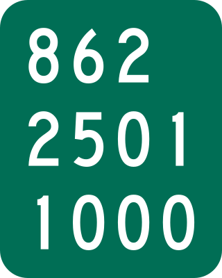
New York State Route 920P (NY 920P) is an unsigned reference route designation for Riverside Drive in the Montgomery County town of Glen, New York, in the United States. The roadway connects NY 30A and NY 5S to exit 28 of the New York State Thruway in the village of Fultonville. Most of Riverside Drive runs alongside the Mohawk River. Although the route is inventoried by the New York State Department of Transportation (NYSDOT) as NY 920P, the reference markers bear the number 862.

<span class="mw-page-title-main">New York State Route 914T</span> State highway in Schenectady County, New York, US

New York State Route 914T (NY 914T) is an unsigned reference route designation for the portion of Balltown Road south of Union Street in Schenectady, New York, in the United States. The route is a short two-lane highway just east of the city limits, running from NY 5 to its intersection with Union Street where NY 146 meets. East of Balltown Road, Union Street is maintained by the New York State Department of Transportation as unsigned NY 911G; however, there are no markers to this effect. Balltown Road is nearly north–south with very few turns. It eventually reaches the town of Ballston in Saratoga County.

<span class="mw-page-title-main">New York State Route 915E</span> Reference route in New York State

New York State Route 915E (NY 915E) is an unsigned reference route designation for Third Avenue Extension in East Greenbush, located in Rensselaer County, New York, in the United States. The east–west highway extends for 1.67 miles (2.69 km) from an intersection with NY 151 east of the Rensselaer city limits to a junction with U.S. Route 4 (US 4) south of the hamlet of Defreestville. NY 915E was designated as New York State Route 381 from the late 1930s to 1962 and part of NY 43 from that time to the late 1990s, when it gained its current designation.

<span class="mw-page-title-main">Numbered highways in New York</span> Highway system

The New York State Department of Transportation (NYSDOT) is responsible for the establishment and classification of a state highway network which includes Interstate Highways, U.S. Highways, and state routes. U.S. and Interstate Highways are classified as state routes in New York; however, a letter is suffixed to the number of the route. As a result, there is apparent duplication between U.S. Routes, Interstate Highways and state routes.

<span class="mw-page-title-main">Cold Spring Harbor station</span> Long Island Rail Road station in Suffolk County, New York

Cold Spring Harbor is a station on the Long Island Rail Road's Port Jefferson Branch. It is located at West Pulaski Road and East Gate Drive, just south of Woodbury Road in West Hills, Suffolk County, New York.

The South Mall Arterial is a 0.52-mile (0.84 km) arterial road in Albany, New York, in the United States. It begins at an intersection with Swan Street and runs eastward under the Empire State Plaza to the west end of the Dunn Memorial Bridge, where the highway ends at an interchange between Interstate 787 (I-787), U.S. Route 9 (US 9), and US 20. The road is maintained by the New York State Department of Transportation (NYSDOT) as New York State Route 913V (NY 913V), an unsigned reference route.

In New York, a reference marker is a small green sign mounted approximately every one-tenth mile on highways maintained by the New York State Department of Transportation. This was initiated in response to the Highway Safety Act of 1966 enacted by Congress, in an effort to monitor traffic and identify high-accident locations. New York's system inventories and indexes all touring and reference routes, in addition to service and rest areas, ramps, and reservation roads.

<span class="mw-page-title-main">Blue Ridge Road</span> Highway in New York

Blue Ridge Road is a 19.2-mile (30.9 km) long roadway in Essex County, New York, in the United States. The road is designated as County Route 84 (CR 84) from NY 28N in Newcomb to Interstate 87 (I-87) in North Hudson, and as New York State Route 910K (NY 910K) between I-87 and U.S. Route 9 (US 9) in North Hudson. The CR 84 portion is an 18-mile (29 km), two-lane stretch of rural highway maintained by the Essex County Department of Public Works' Highway Division while NY 910K is a 1 mile (1.6 km) highway maintained by the New York State Department of Transportation (NYSDOT). All of Blue Ridge Road has been designated as the "Blue Ridge Road Scenic Byway" by NYSDOT.

<span class="mw-page-title-main">New York State Route 338 (1980–1996)</span> Former state highway in New York State

New York State Route 338 (NY 338) was a 7.04-mile-long (11.33 km) state highway in Washington County, New York, in the United States. The western terminus of the route was at NY 40 in South Argyle, a hamlet in the town of Argyle. Its eastern terminus was at NY 29 in Greenwich. NY 338 connected both highways to the hamlet of Cossayuna and nearby Cossayuna Lake in northeast Greenwich.

References

General references
Inline references
  1. "Bridge Inventory Manual" (PDF). New York State Department of Transportation. 2006. p. 107. Retrieved April 1, 2010.
  2. For example, from 15 NYCRR 2042.01 City of Schenectady: "State Street, Route 5, SH 9213, at its intersection with Washington Avenue."
  3. 1 2 3 4 5 6 "1993 Traffic Volume Report for New York State" (Document). New York State Department of Transportation.
  4. Google Maps, , March 2022
  5. New York State Department of Transportation, Official Description of Designated Qualifying and Access Highways in New York State, October 2020
  6. 1 2 3 4 5 6 7 8 9 10 11 12 13 14 15 New York State Department of Transportation (October 2007). Official Description of Highway Touring Routes, Bicycling Touring Routes, Scenic Byways, & Commemorative/Memorial Designations in New York State.
  7. 1 2 3 4 5 6 New York State Department of Transportation (January 2009). Official Description of Highway Touring Routes, Bicycling Touring Routes, Scenic Byways, & Commemorative/Memorial Designations in New York State.
  8. 1 2 3 4 5 New York State Department of Transportation (January 2012). Official Description of Highway Touring Routes, Bicycling Touring Routes, Scenic Byways, & Commemorative/Memorial Designations in New York State (PDF). Archived from the original (PDF) on July 29, 2013. Retrieved February 16, 2012.
  9. "Regular Meeting" (PDF). Town of Ephratah, NY. August 8, 2012. Retrieved May 28, 2020.
  10. "NOTICE OF DESIGN APPROVAL PROJECT IDENTIFICATION NUMBER 2079.00.101". Leader-Herald. 1976-03-23. p. 25.
  11. Southeast Arterial Hwy, Route 169 Replacement, Little Falls: Environmental. NYSDOT. 1975. p. 34. Retrieved March 30, 2020.
  12. Southeast Arterial Hwy, Route 169 Replacement, Little Falls: Environmental. NYSDOT. 1975. p. 23. Retrieved June 5, 2020.
  13. 1 2 3 4 5 6 New York State Legislature. "Bills of New York State – bill number-based search" . Retrieved February 5, 2010. The relevant bill is number S4856, passed during the 2007 legislative session.
  14. New York (Map). Cartography by H.M. Gousha Company. Kendall Refining Company. 1931.
  15. Texaco Road Map – New York (Map). Cartography by Rand McNally and Company. Texas Oil Company. 1932.
  16. New York with Special Maps of Putnam–Rockland–Westchester Counties and Finger Lakes Region (Map) (1958 ed.). Cartography by General Drafting. Esso. 1958.
  17. New York and New Jersey Tourgide Map (Map). Cartography by Rand McNally and Company. Gulf. 1960.
  18. 1 2 3 4 5 6 7 8 9 10 11 12 13 14 15 New York State Department of Transportation (October 2004). Official Description of Highway Touring Routes, Scenic Byways, & Bicycle Routes in New York State (PDF). Retrieved July 16, 2009.
  19. "Ontario County traffic counts" (PDF). New York State Department of Transportation. 2003. Retrieved August 5, 2009.
  20. New York State Legislature. "New York State Highway Law § 341" . Retrieved February 9, 2012.
  21. New York State Department of Transportation (January 2017). Official Description of Highway Touring Routes, Bicycling Touring Routes, Scenic Byways, & Commemorative/Memorial Designations in New York State (PDF). Retrieved January 16, 2017.
  22. "Road Swap, Including Controversial BRasher Section, Wall Again, Come Before County". The Courier and Freeman. Potsdam, New York. March 4, 1980. p. 16. Retrieved January 11, 2024.
  23. 1 2 3 4 5 6 7 8 "Bridge Inventory Manual – Appendix G: State Touring Route Numbers for Named Roads" (PDF). New York State Department of Transportation. April 2005. Archived from the original (PDF) on March 4, 2016. Retrieved April 1, 2010.