The Niagara River flows north from Lake Erie to Lake Ontario, forming part of the border between Ontario, Canada, to the west, and New York, United States, to the east. The origin of the river's name is debated. Iroquoian scholar Bruce Trigger suggests it is derived from a branch of the local Neutral Confederacy, referred to as the Niagagarega people on several late-17th-century French maps. George R. Stewart posits that it comes from an Iroquois town named Ongniaahra, meaning "point of land cut in two."

Lewiston is a village in Niagara County, New York, United States. The population was 2,701 at the 2010 census. The village is named after Morgan Lewis, an early 19th-century governor of New York. It is part of the Buffalo–Niagara Falls Metropolitan Statistical Area.
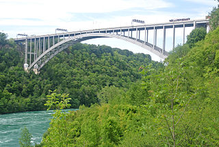
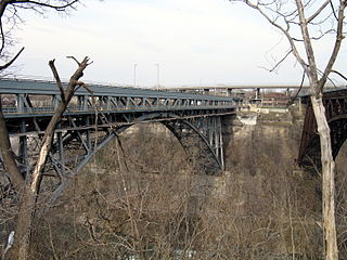
The Lewiston–Queenston Bridge, also known as the Queenston–Lewiston Bridge, is an arch bridge that crosses the Niagara River gorge just south of the Niagara Escarpment. The bridge was officially opened on November 1, 1962. It is an international bridge between the United States and Canada. It connects Interstate 190 in the town of Lewiston, New York to Highway 405 in the community of Queenston, Ontario. The Lewiston–Queenston Bridge is architecturally similar to the Rainbow Bridge at nearby Niagara Falls.
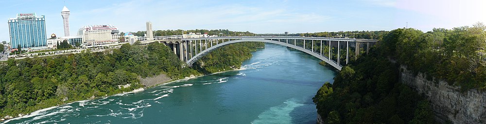
The Whirlpool Rapids Bridge, commonly known as the Whirlpool Bridge or the Lower Steel Arch Bridge, is a spandrel braced, riveted, two-hinged arch bridge that crosses the Canada–United States border, connecting the commercial downtown districts of Niagara Falls, Ontario, and Niagara Falls, New York. This bridge is located approximately 1.5 kilometres (0.9 mi) north of the Rainbow Bridge and about 2 kilometres (1.2 mi) from the Falls. It was acquired by the Niagara Falls Bridge Commission in January 1959. Immediately upstream is the similar arch-style Michigan Central Railway Bridge, which has been out of service since 2001.
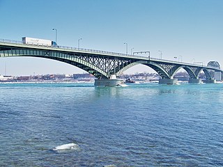
The Peace Bridge is an international bridge between Canada and the United States at the east end of Lake Erie at the source of the Niagara River, about 20 kilometres (12.4 mi) upriver of Niagara Falls. It connects Buffalo, New York, in the United States to Fort Erie, Ontario, in Canada. It is operated and maintained by the binational Buffalo and Fort Erie Public Bridge Authority.
King's Highway 405, also known as Highway 405 and the General Brock Parkway, is a 400-Series Highway in the Canadian province of Ontario connecting the Queen Elizabeth Way (QEW) near St. Catharines with the Lewiston–Queenston Bridge in the village of Queenston. It then crosses the Niagara River, where it encounters the international border with the United States and continues into New York as Interstate 190 (I-190).
King's Highway 420, commonly referred to as Highway 420, is a 400-series highway in the Canadian province of Ontario that connects the Queen Elizabeth Way (QEW) with downtown Niagara Falls. It continues east as a limited-access expressway named Niagara Regional Road 420 to connect with the Rainbow Bridge international crossing between Canada and the United States over the Niagara River; this was part of Highway 420 until 1998. West of the QEW, the freeway ends at an at-grade intersection with Montrose Road. The highway has a speed limit of 80 kilometres per hour (50 mph), making it the only 400-series highway to have a speed limit less than 100 kilometres per hour (62 mph) for its entirety.
Interstate 190 is a north–south auxiliary Interstate Highway in the United States that connects I-90 in Buffalo, New York, with the Canada–United States border at Lewiston, New York, near Niagara Falls. Officially, I-190 from I-90 north to New York State Route 384 (NY 384) is named the Niagara Thruway and is part of the New York State Thruway system. The remainder, from NY 384 to Lewiston, is known as the Niagara Expressway and is maintained by the New York State Department of Transportation (NYSDOT).

Niagara Gorge is an 11 km (6.8 mi) long canyon carved by the Niagara River along the Canada–United States border, between the U.S. state of New York and the Canadian province of Ontario. It begins at the base of Niagara Falls and ends downriver at the edge of the geological formation known as the Niagara Escarpment near Queenston, Ontario, where the falls originated about 12,500 years ago. The position of the falls has receded upstream toward Lake Erie because of the falling waters' slow erosion of the riverbed's hard Lockport dolomite, combined with rapid erosion of the relatively soft layers beneath it. This erosion has created the gorge.
The Buffalo and Fort Erie Public Bridge Authority is the agency established to regulate the Peace Bridge, which crosses the Canada–United States border. This bridge is designed to handle vehicle traffic between Buffalo in the American state of New York and Fort Erie in the Canadian province of Ontario.
The Niagara Falls Bridge Commission is an international public agency which administers three international bridges across the Niagara River connecting the province of Ontario, Canada, and the state of New York, United States: the Lewiston–Queenston Bridge, Whirlpool Rapids Bridge and Rainbow Bridge. The NFBC is incorporated as a class D New York State public benefit corporation and is licensed to operate in Ontario under the Extra-Provincial Corporations Act. The commission is based in Lewiston, New York, and maintains a post office box address in Niagara Falls, Ontario. It is mostly self-supporting from tolls, leases, and commercial concessions.

The Great Gorge Route or Niagara Belt Line was an interurban trolley belt line encompassing the Niagara Gorge, operated by the International Railway and Niagara Gorge Railroad. Many dignitaries rode this line and they used to use a flat car with search light to illuminate the Niagara Whirlpool at night.

The Michigan Central Railway Bridge is an out-of-service steel Deck arch bridge spanning the Niagara Gorge between Niagara Falls, Ontario and Niagara Falls, New York. The bridge is owned by Canadian Pacific Kansas City, which purchased the single track structure in 1990. The Canadian corridor and bridge are owned by the City of Niagara Falls, Ontario. The bridge is located just upstream from the older arch-style Whirlpool Rapids Bridge used by Maple Leaf Amtrak passenger trains.

The Niagara Scenic Parkway is a 16.4-mile (26.39 km) north-south parkway in western Niagara County, New York, in the United States. Its southern terminus is at the LaSalle Expressway on the east bank of the Niagara River in Niagara Falls. The northern terminus is at New York State Route 18 (NY 18) at Four Mile Creek State Park in Porter near Lake Ontario. Originally, the parkway was one continuous road; however, due to low usage, a portion of the parkway near Niagara Falls was removed, separating the parkway into two sections. The length of the parkway is designated as New York State Route 957A by the New York State Department of Transportation (NYSDOT). A 1.16-mile (1.87 km) long spur connecting the Niagara Scenic Parkway to Fort Niagara State Park near Youngstown is designated as New York State Route 958A. Both reference route designations are unsigned.
The Niagara Gorge Railroad was an interurban railway which ran at the bottom of the Niagara Gorge from Niagara Falls, New York to Lewiston, New York.

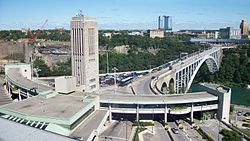
The Rainbow Tower is a 50.3 metres (165 ft) tower located at the Rainbow Plaza Canada–United States border station of the Rainbow Bridge in Niagara Falls, Ontario, Canada. Construction on the tower was completed in 1947. The tower, part of the Canadian plaza of the bridge, was designed by Canadian architect William Lyon Somerville.
The Theodore Roosevelt International Highway was a transcontinental North American highway, from the era of the auto trails, through the United States and Canada that ran from Portland, Maine, to Portland, Oregon. Its length was about 4,060 miles (6,530 km).
Freedom Crossing Monument is located on the bank of the Niagara River in Lewiston, New York, and honors the courage of fugitive slaves who sought a new life of freedom in Canada, and to the local volunteers who protected and helped them on their journey across the Niagara River. It was dedicated on October 14, 2009.