This is a list of rivers in East Timor. The list is arranged by catchment or drainage basin from west to east, with respective tributaries indented under each larger stream's name.
Contents

This is a list of rivers in East Timor. The list is arranged by catchment or drainage basin from west to east, with respective tributaries indented under each larger stream's name.
East Timor has over 100 rivers originating in the highlands and discharging into the coastal zone. As the island of Timor is small and the country's topography is steep, the rivers are short and drain quickly, with fast flowing discharges. [1] : 21 [2] : xvi, 3, 75
A drainage divide trends approximately from southwest to northeast along East Timor's central mountain range; [3] rain falling north of the divide flows northwards, and that falling to its south drains southwards. [4]
The country has also been broadly divided into twelve 'hydrologic units', groupings of climatologically and physiographically similar and adjacent river catchments or drainage basins. Each hydrologic unit is made up of a number of rivers. In total, there are 29 main river systems in East Timor – 12 in the north and 17 in the south. [5] : 2, 52 [6]
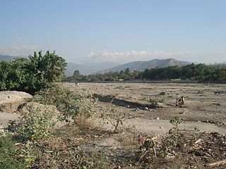
Very few of East Timor's rivers flow perennially, because the country is narrow from north to south, and has steep terrain and infrequent rain. Most of the rivers have short courses, are dry most of the year, and are not navigable. In the dry season, the ephemeral rivers often form pools of stagnant water. [2] : xvi, 3, 75 [4] The south has more perennial rivers than the north because of its larger catchment areas, longer rainy season, greater rainfall and prevailing winds. [1] : 21 [2] : 75
According to a Timor-Leste Water Sector Assessment and Roadmap published by The World Bank in 2018:
"The monsoon climate results in highly variable river flows from wet season peaks and flash floods to low or no dry season flows. Along the northern coastline are many of the smaller river catchments that are either semi-permanent or ephemeral, flowing for short periods in the wet season after heavy rainfall events. This contrasts with the south coast where the bimodal wet seasons and higher rainfall has resulted in many large permanent rivers that have high peak flows in the wet season, which are reduced to the base flow during the dry season. At all times, subsurface flows occur below the gravel and cobblestone riverbeds of most rivers, and in the dry season, this can represent the primary flows within a river, particularly in lowland areas." [7]
During periods of greater precipitation, the rivers in the south cannot accommodate the whole of their flow, and therefore overspill into coastal swamps and lagoons known as coilões. [1] : 21–22
On the north coast, most rivers are choked with nearshore gravel, and there are few deltas. The reason is that the offshore gradient, into either Ombai Strait or Wetar Strait, is very steep, with the consequence that sediment that flows offshore is deposited in deep water. On the south coast, where the offshore gradient into the Timor Sea is much gentler, deltas are common. [8] : 6–7 [9] : 35
Many of East Timor's rivers are polluted by sewage released from homes and light industrial premises, due to a lack of basic sanitation. Additionally, the majority of the population uses river water for washing clothes, bathing and other domestic uses, and thus promotes the spread of diseases. [1] : 23
East Timor's longest river is the North Laclo, at about 80 km (50 mi) long; [1] : 22 [4] [10] its largest catchment is that of the Loes, [1] : 22 which has a total area of 2,184 km2 (843 sq mi) (almost 15% of the whole country), about 9% of which lies in Indonesia. [11]
The people of East Timor often have no single common name for, or any single spelling of any name allocated to, a particular river. Further, an East Timorese river may change its name several times between its source and its mouth. [12] The names set out below are therefore not necessarily authoritative, either as to the name of a river, or as to the spelling of any particular name.

A flood is an overflow of water that submerges land that is usually dry. In the sense of "flowing water", the word may also be applied to the inflow of the tide. Floods are an area of study of the discipline hydrology and are of significant concern in agriculture, civil engineering and public health. Human changes to the environment often increase the intensity and frequency of flooding, for example land use changes such as deforestation and removal of wetlands, changes in waterway course or flood controls such as with levees, and larger environmental issues such as climate change and sea level rise. In particular climate change's increased rainfall and extreme weather events increases the severity of other causes for flooding, resulting in more intense floods and increased flood risk.

A drainage basin is any area of land where precipitation collects and drains off into a common outlet, such as into a river, bay, or other body of water. The drainage basin includes all the surface water from rain runoff, snowmelt, hail, sleet and nearby streams that run downslope towards the shared outlet, as well as the groundwater underneath the earth's surface. Drainage basins connect into other drainage basins at lower elevations in a hierarchical pattern, with smaller sub-drainage basins, which in turn drain into another common outlet.

An endorheic basin is a drainage basin that normally retains water and allows no outflow to other external bodies of water, such as rivers or oceans, but drainage converges instead into lakes or swamps, permanent or seasonal, that equilibrate through evaporation. They are also called closed or terminal basins, internal drainage systems, or simply just basins. Endorheic regions contrast with exorheic regions. Endorheic water bodies include some of the largest lakes in the world, such as the Caspian Sea, the world's largest inland body of water.
The south-west corner drainage region of Western Australia is one of only two temperate and relatively fertile parts of mainland Australia. It covers about 140,000 square kilometres (54,000 sq mi), or a little less than 2% of the continent. For comparison, this is about the same size as North Carolina or a little larger than England.

The Avoca River, an inland intermittent river of the north–central catchment, part of the Murray-Darling basin, is located in the lower Riverina bioregion and Central Highlands and Wimmera regions of the Australian state of Victoria. The headwaters of the Avoca River rise on the northern slopes of the Pyrenees Range and descend to flow into the ephemeral Kerang Lakes.
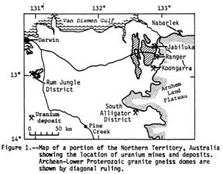
Alligator Rivers is the name of an area in an Arnhem Land region of the Northern Territory of Australia, containing three rivers, the East, West, and South Alligator Rivers. It is regarded as one of the richest biological regions in Australia, with part of the region in the Kakadu National Park. It is an Important Bird Area (IBA), lying to the east of the Adelaide and Mary River Floodplains IBA. It also contains mineral deposits, especially uranium, and the Ranger Uranium Mine is located there. The area is also rich in Australian Aboriginal art, with 1500 sites. The Kakadu National Park is one of the few World Heritage sites on the list because of both its natural and human heritage values. They were explored by Lieutenant Phillip Parker King in 1820, who named them in the mistaken belief that the crocodiles in the estuaries were alligators.
The Lost Coast is a mostly natural and undeveloped area of the California North Coast in Humboldt and Mendocino Counties, which includes the King Range. It was named the "Lost Coast" after the area experienced depopulation in the 1930s. In addition, the steepness and related geotechnical challenges of the coastal mountains made this stretch of coastline too costly for state highway or county road builders to establish routes through the area, leaving it the most undeveloped and remote portion of the California coast. Without any major highways, communities in the Lost Coast region such as Petrolia, Shelter Cove, and Whitethorn are isolated from the rest of California.
Manufahi is one of the municipalities of East Timor. It has a population of 53,691 and an area of 1,323 km2. The capital of the municipality is Same.
The Sandover River is an ephemeral river in the Northern Territory of Australia located in northeast Central Australia. It is the only major tributary of the Georgina River that does not rise in western Queensland. Instead it flows from the eastern Macdonnell Ranges, northward to enter the Georgina near Urandangi. The highest point in the catchment is Bald Hill at 996 metres (3,268 ft), but it enters the Georgina at altitudes below 200 metres (660 ft).
A dambo is a class of complex shallow wetlands in central, southern and eastern Africa, particularly in Zambia and Zimbabwe. They are generally found in higher rainfall flat plateau areas and have river-like branching forms which in themselves are not very large but combined add up to a large area. Dambos have been estimated to comprise 12.5% of the area of Zambia. Similar African words include mbuga, matoro (Mashonaland), vlei, fadama (Nigeria), and bolis ; the French bas-fond and German Spültal have also been suggested as referring to similar grassy wetlands.

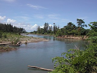
The Loes River is a river in East Timor and one of the few perennial rivers in its north. It combines with its tributaries to make up the country's largest river system, and its catchment or drainage basin extends into the province of East Nusa Tenggara in Indonesia.
The North Laclo River is the longest river in East Timor. It flows northeast into Wetar Strait, reaching the coast near the city of Manatuto. It has no connection to the South Laclo, which flows into the Timor Sea.

The Caraulun River is a river in East Timor. It flows for the most part in a southerly direction, forms the southern part of the border between Ainaro and Manufahi municipalities, and discharges into the Timor Sea.
The Comoro River is a river in East Timor. It flows north into Ombai Strait, reaching the coast in the north western suburbs of the capital, Dili. In its lower reaches, it is the main and largest of Dili's four major rivers.

The Bulloo RiverBUUL-oo is an isolated drainage system in western Queensland, central Australia. Its floodplain, which extends into northern New South Wales, is an important area for waterbirds when inundated. It comprises most of the Bulloo-Bancannia drainage basin.

A stream is a continuous body of surface water flowing within the bed and banks of a channel. Depending on its location or certain characteristics, a stream may be referred to by a variety of local or regional names. Long large streams are usually called rivers, while smaller, less voluminous and more intermittent streams are known as streamlets, brooks or creeks.

The Vellar River is a river in the Indian state of Tamil Nadu. It originates in the Kalrayan Hills, and flows generally eastward through Salem, Perambalur, and Cuddalore districts, before flowing into the Bay of Bengal near Parangipettai. The river has a total length of 150 kilometres (93 mi), and its drainage basin covers an area of 7,504.346 square kilometres (2,897.444 sq mi) in Cuddalore, Perambalur, Salem, Kallakurichi, Ariyalur, Namakkal, Tiruchirappalli, and Dharmapuri districts.
Elizabeth River flows into Darwin Harbour close to Darwin in the Northern Territory of Australia.
The Irabere River, sometimes spelt Irebere River, is a river in East Timor, a country occupying the eastern end of the island of Timor in the Lesser Sunda Islands of Wallacea.

The South Laclo River is a river in the Manufahi municipality of East Timor. It flows southwards, and then southeastwards, into the Timor Sea.