List of rivers of China

Last updated

Rivers that flow through China are as follows. The list is organized according to the body of water into which each river empties, beginning with the Sea of Okhotsk in the northeast, moving clockwise on a map and ending with the Arctic Ocean.

Contents

Sea of Okhotsk

Amur River basin Amurrivermap.png
Amur River basin

Sea of Japan

Bohai Sea

Liao River Basin Liaorivermap.png
Liao River Basin
Wei River Basin Weirivermap.png
Wei River Basin
Yellow River Basin Yellowrivermap.jpg
Yellow River Basin

Yellow Sea

Yalu River Yalurivermap.png
Yalu River
Huai River basin Huairivermap.jpg
Huai River basin

East China Sea

Hanshuirivermap.png
Han River Basin of Hubei, southern Shaanxi and southwestern Henan
Lake Dongting and the Lishui, Yuan, Zi, Xiang and Miluo Rivers of Hunan. Dongtingriversmap.png
Lake Dongting and the Lishui, Yuan, Zi, Xiang and Miluo Rivers of Hunan.
Jialingrivermap.png
Jialing River Basin of Chongqing, eastern Sichuan and southern Gansu
Min sichuan rivermap.png
Min River of central Sichuan
Yalongrivermap.png
Yalong River of western Sichuan and southern Qinghai

Taiwan Strait

South China Sea

Pearl River Basin Zhujiangrivermap.png
Pearl River Basin
Red River (Asia) watershed Red hong rivermap.png
Red River (Asia) watershed
Lancang (Mekong) River watershed Mekong River watershed.png
Lancang (Mekong) River watershed

From Hainan Island

Nandu River (map), Hainan Province Hainan - Haikou - Nandu rivermap.png
Nandu River (map), Hainan Province

Andaman Sea

Nu (Salween) River Salween watershed.png
Nu (Salween) River

Bay of Bengal

Map of the Ganges (yellow), Brahmaputra (violet), and Meghna (green) drainage basins. Ganges-Brahmaputra-Meghna basins.jpg
Map of the Ganges (yellow), Brahmaputra (violet), and Meghna (green) drainage basins.

Arabian Sea

Arctic Ocean

Ob-Irtysh watershed Ob watershed.png
Ob-Irtysh watershed

Endorheic basins

Dzungarian Basin

Ili Basin

Ili Basin Lakebalkhashbasinmap.png
Ili Basin

Juyan Lake Basin

Lake Alakol

Qaidam Basin

NJ-46 Ko-erh-mu.jpg
NJ 47 Hsi-ning.jpg
Detailed US Army maps of Qaidam, c. 1975. (Names given in Wade-Giles romanization.)

Tarim Basin

Tarim Basin Tarimrivermap.png
Tarim Basin

Canals

See also

Related Research Articles

<span class="mw-page-title-main">Liao River</span> Major river in Northeast China

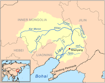
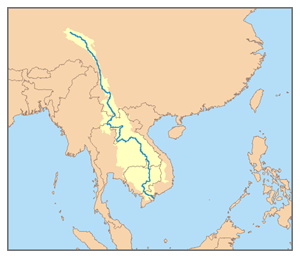
The Liao River is the principal river in southern Northeast China, and one of the seven main river systems in China. Its name derived from the Liao region, a historical name for southern Manchuria, from which the Liaoning province, Liaodong Peninsula and Liao dynasty also all have derived their names. The river is also popularly known as the "mother river" in Northeast China. Coursing 1,345 kilometres (836 mi) long, the Liao River system drains a catchment basin of over 232,000 square kilometres (90,000 sq mi), but its mean discharge is quite small at only about 500 cubic metres per second (18,000 cu ft/s), about one-twentieth that of the Pearl River. The Liao River has an exceedingly high sediment load because many parts of it flow through powdery loess.

Bu'erjin Kanasi Airport is an airport that serves Burqin County and the nearby tourist destination Kanas Lake in Xinjiang, China. It is located 50 kilometers south of the lake in Burqin County. The airport was constructed in 2006 and opened on 15 August 2007. Until 2019, the airport was only open for flights in the summer.

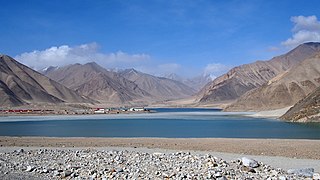
The Burqin Shankou Dam is an arch dam in Burqin County of Xinjiang Uighur Autonomous Region of China.

<span class="mw-page-title-main">Fuyi River</span> River in China

Fuyi River, also known as Luojiang River (罗江), Fuyijiang (夫夷江) and Fuyihe (夫夷河) is a river in China's Guangxi and Hunan provinces. It is one of the largest tributaries of the Zi River. Fuyi River is 352.6 km (219.1 mi) long and has a drainage basin of 6,692 km2 (2,584 sq mi). The river's origin is within Cat Mountain (猫儿山), in Guangxi.

<span class="mw-page-title-main">Bulungkol</span> Township in Xinjiang, Peoples Republic of China

Bulungkol Township is a township of Akto County in Xinjiang, China. Located in the middle west of the county, the township covers an area of 4,585 square kilometers with a population of 7,133. It has 5 administrative villages under its jurisdiction. Its seat is at Bulungkol Village (布伦口村).

References

  1. 中国河湖大典·黄河卷. Beijing: 中国水利水电出版社. ISBN   978-7-5170-1937-4.