
Westmoreland is the westernmost parish in Jamaica, located on the south side of the island. It is situated south of Hanover, southwest of Saint James, and northwest of Saint Elizabeth, in the county of Cornwall. The chief town and capital is Savanna-la-Mar. Negril, a famous tourist destination, is also situated in the parish.

Hanover is a parish located on the northwestern tip of the island of Jamaica. It is a part of the county of Cornwall, bordered by St. James in the east and Westmoreland in the south. With the exception of Kingston, it is the smallest parish on the island. Hanover is the birth parish of Alexander Bustamante, labour leader, first head of government of Jamaica under universal suffrage, and one of seven Jamaican National Heroes. Its capital is Lucea.
South Negril Point is the westernmost point of mainland Jamaica. It is located a little south of the resort town of Negril and a little north of Negril Lighthouse.
Green Island is a small town in northwestern Jamaica, located on the west coast between Negril and Lucea in the parish of Hanover. It is located close to Orange Bay.
The Kingston to Montego Bay railway was the main railway in Jamaica, which from 1845 to 1992 linked the capital Kingston with the second city Montego Bay, passing en route most of the major towns.
The Linstead to New Works railway was a railway in Jamaica constructed in 1921 to serve a citrus growing region to the north east of Linstead.
The Spanish Town to Ewarton railway was a railway in Jamaica, built to serve the citrus growing regions in the interior of Saint Catherine, particularly those around the towns of Bog Walk, Linstead and Ewarton. It operated from 1885 to 1992.
Frankfield is a town in the parish of Clarendon in central Jamaica. It is located near the top of Jamaica's central ridge of mountains overlooking the south coast. The Rio Minho river runs through the town in a shallow gorge.
The Cane River rises at twin sources in the vicinity of Derby Peak in eastern Saint Andrew Parish, Jamaica from where it flows south to the Caribbean Sea.
The Dry River is a river in St Mary, Jamaica.
The Guava River rises just north of the Grand Ridge of the Blue Mountains on the border of Portland Parish in Jamaica. From here it runs east then north and then east again to its confluence with the Rio Grande.

The South Negril River is a river in Westmoreland, Jamaica.
The One-Eye River is a river in the parishes of Manchester and St Elizabeth in Jamaica. It is a tributary of the Black River.

The Rio Cobre is a river of Jamaica. Its source is in the Rose Hall Mountain in the north-east of Saint Catherine Parish, the headwaters being a writhing of unnamed, seasonally dry tributaries. The highest of these rise just above the 1,135 feet (346 m) contour. From here it flows to meet the Caribbean Sea into the Hunts Bay. It is dammed by the Rio Cobre Dam just above Spanish Town.
The Stony River (Jamaica) rises just north of Coopers Hill in Saint Catherine Parish, Jamaica. From here it flows primarily north until it reaches its confluence with the New River.
Hodges, Jamaica is located in Saint Elizabeth, Jamaica. It is a small hamlet on the main A2 road about 2 miles (3.2 km) north-west of Black River. It was the plantation village of Hodges estate which is bordered by the Caribbean Sea to the south and is east of Crawford, Jamaica.
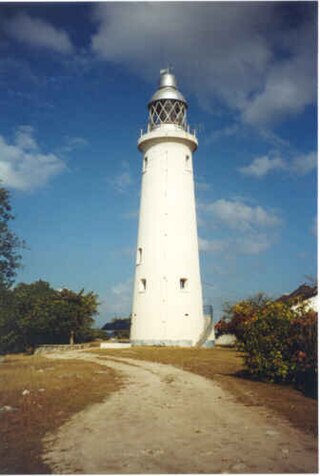
Negril Lighthouse was built in 1894 1.5 miles (2.4 km) south south east of the westernmost tip of the island of Jamaica by the French company Barber & Bernard. It is one of the earliest concrete lighthouses.
The Rotten Gut River is a short river in the parish of Manchester, Jamaica and a tributary of the One Eye River.
The Juan de Bolas River rises in Saint Catherine, Jamaica, and flows through Saint Catherine and Clarendon. It is one of two rivers in Jamaica named after Juan de Bolas, the first Chief of the Jamaican Maroons.
Orange Bay is a small bay in Hanover Parish, Jamaica to the north of the resort town of Negril.


