Parishes of Jamaica

Last updated

Parish
Jamaica parishes numbered2.pngHanoverSaint ElizabethSaint JamesTrelawny ParishWestmorelandClarendonManchesterSaint AnnSaint CatherineSaint MaryKingston ParishPortlandSaint AndrewSaint Thomas
Category Unitary state
LocationFlag of Jamaica.svg  Jamaica
Found in Counties of Jamaica
Created
Number14 parishes (since 1866)
Populations69,533 (Hanover) – 573,369 (Saint Andrew)
Areas25 km2 (9.7 sq mi) (Kingston) – 1,213 km2 (468 sq mi) (Saint Ann)
Government
  • Parish government
Subdivisions
  • Cities, Towns, Villages

The parishes of Jamaica are the main units of local government in Jamaica. They were created following the English Invasion of Jamaica in 1655. This administrative structure for the Colony of Jamaica developed slowly. However, since 1 May 1867, Jamaica has been divided into the current fourteen parishes. These were retained after independence in 1962. They are grouped into three historic counties, which no longer have any administrative relevance. Every parish has a coast; none are landlocked.

Contents

List

Parish Capital Area
km2
Population
Census 2011 [1]
Cornwall County
1 Hanover Lucea 450.469,533
2 Saint Elizabeth Black River 1,212.4150,205
3 Saint James Montego Bay 594.9183,811
4 Trelawny Falmouth 874.675,164
5 Westmoreland Savanna-la-Mar 807.0144,103
Middlesex County
6 Clarendon May Pen 1,169.3245,103
7 Manchester Mandeville 830.1189,797
8 Saint Ann Saint Ann's Bay 1,212.6172,362
9 Saint Catherine Spanish Town 1,192.4516,218
10 Saint Mary Port Maria 610.5113,615
Surrey County
11 Kingston Parish [lower-alpha 1] [lower-alpha 2] Kingston 21.889,057
12 Portland Port Antonio 814.081,744
13 Saint Andrew [lower-alpha 1] Half Way Tree 430.7573,369
14 Saint Thomas Morant Bay 742.893,902
Total10,991.02,697,983
  1. 1 2 The parishes of Kingston and Saint Andrew together form the Kingston and St. Andrew Corporation .
  2. The parish of Kingston does not encompass all of the city of Kingston. Most of the city is in the parish of St. Andrew.
Map of the parishes of Jamaica. Jamaica, administrative divisions (parishes) - en - monochrome.svg
Map of the parishes of Jamaica.

History

Early history

Following the English conquest of Jamaica the first phase of colonisation was carried out by the Army, with a system of Regimental plantations. These were drawn up on the southern flat lands, with the Regimental commanders charged with ordering their men to plant provisions. [2] :135

Certain key figures such as Luke Stokes (1656) [3] and Thomas Modyford (1664) [4] brought substantial numbers of colonists from other English colonies. In 1662 the first census was carried out. There were no parishes and the division of the island into ten districts. [5] [6]

DistrictMenWomenChildrenBlacksArmsAcres
in cultivation
1In the precinct of Port Moranto 1686037126120446
2In the precinct of Morant12214175375129
3In the precinct of Yealoth (Yallahs)20736255472355
4In the precinct of Legene55314912554300549
5The town of Angelo Delvega (St Jago de la Vega)207524253100100
6Between Black River, Bower Savanna and thereabouts178221227120200
7In the Angles Quarters10020144656170
8In the Seven Plantations, Macaria, Quathabeca (Guatibacoa)275502050150250
9In the quarters Quanaboa (Guanaboa Vale) and Quardalena390422639330700
10Upon Point Caugway (Cageway, i.e. Port Royal [2] :153)4002009050300...
Total2,6006454085521,5232,917

Creation of the parishes

1671 map by Richard Bloome, completed on the instructions of Modyford Map Jamaica 1671.jpg
1671 map by Richard Bloome, completed on the instructions of Modyford

Under Governor Modyford the island was divided into precincts and parishes and he commissioned a map of the island featuring these.[ citation needed ] The first parishes were: [7]

By 1675, the following parishes had been added: [7]

In 1677, An Act for Regulating the Parishes fixed the boundaries of each parish. [7]

The Grant reforms

The parishes of Jamaica in 1893 Map of the island of Jamaica LOC 2012586632.jpg
The parishes of Jamaica in 1893

The crisis highlighted by the Morant Bay rebellion led to the dissolution of the House of Assembly of Jamaica, and the colonial administration being turned into a crown colony. John Peter Grant was appointed Governor arriving in August 1866, and he set about instituting a number of reforms, including the administrative framework of the parishes. He introduced the by which the 22 existing parishes to 14 through the A Law to Reduce the Number of Parishes (1867/No. 20). Parishes have been a feature of local administration in Jamaica since the island was captured by the English in 1655. [8] The number has varied over time and some no longer exist having either been absorbed into or divided between neighbouring parishes. [8] At the peak, 1841–1865, there were 22 (the current 14 plus those listed below). [8]

The current set of parishes was established in 1866 with the elimination of the 8 listed below (roughly by county): [8]

Surrey:

Middlesex:

Counties of Jamaica

Map of the counties: 1) Cornwall County, 2) Middlesex County, 3) Surrey County. Jamaica, administrative divisions (counties) - Nmbrs - colored.svg
Map of the counties: 1) Cornwall County, 2) Middlesex County, 3) Surrey County.

Jamaica is divided into three historic counties, though they have no administrative function today. They were established in 1758 to facilitate the holding of courts along the lines of the British county court system. [9]

The three counties are named for the English historic counties of Cornwall, Middlesex, and Surrey. Cornwall County was named for being the westernmost county, just like its namesake. Middlesex County was named for its location on the middle third of Jamaica. Surrey County was named for the English county in which Kingston upon Thames is found, because Kingston was its county town. [9]

CountyPopulation
(Census 2011)
Area in km2 County town
Cornwall County 600,5813,939.3 Savanna-la-Mar
Middlesex County 1,183,3615,041.9 Spanish Town
Surrey County 823,6892,009.3 Kingston
Jamaica2,607,63110,990.5 Kingston

See also

Related Research Articles

<span class="mw-page-title-main">Henry Morgan</span> Privateer and political office holder in Jamaica (1635–1688)

Sir Henry Morgan born Harri Morgan was a Welsh privateer, plantation owner, and, later, Lieutenant Governor of Jamaica. From his base in Port Royal, Jamaica, he raided settlements and shipping on the Spanish Main, becoming wealthy as he did so. With the prize money from the raids, he purchased three large sugar plantations on the island.

<span class="mw-page-title-main">Spanish Town</span> Town in Middlesex, Jamaica

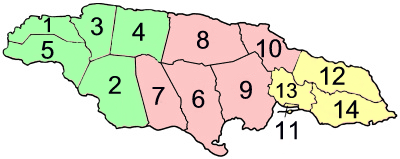
Spanish Town is the capital and the largest town in the parish of St. Catherine in the historic county of Middlesex, Jamaica. It was the Spanish and British capital of Jamaica from 1534 until 1872. The town is home to numerous memorials, the national archives, and one of the oldest Anglican churches outside England.

<span class="mw-page-title-main">Saint Thomas Parish, Jamaica</span> Parish of Jamaica

Saint Thomas, once known as Saint Thomas in the East, is a suburban parish situated at the south eastern end of Jamaica, within the county of Surrey. It is the birthplace of Paul Bogle, designated in 1969 as one of Jamaica's seven National Heroes. Morant Bay, its chief town and capital, is the site of the Morant Bay Rebellion in 1865, of which Bogle was a leader.

<span class="mw-page-title-main">Saint Catherine Parish</span> Parish of Jamaica

Saint Catherine is a parish in the south east of Jamaica. It is located in the county of Middlesex, and is one of the island's largest and most economically valued parishes because of its many resources. It includes the first capital of Jamaica, Spanish Town, originally known as San Jago de la Vega or Santiago de la Vega.

<span class="mw-page-title-main">Saint Elizabeth Parish</span> Parish of Jamaica

Saint Elizabeth, one of Jamaica's largest parishes, is located in the southwest of the island, in the county of Cornwall. Its capital, Black River, is located at the mouth of the Black River, the widest on the island.

<span class="mw-page-title-main">Clarendon Parish, Jamaica</span> Parish of Jamaica

Clarendon is a parish in Jamaica. It is located on the south of the island, roughly halfway between the island's eastern and western ends. Located in the county of Middlesex, it is bordered by Manchester on the west, Saint Catherine in the east, and in the north by Saint Ann. Its capital and largest town is May Pen.

<span class="mw-page-title-main">Saint James Parish, Jamaica</span> Parish of Jamaica

St. James is a suburban parish, located on the north-west end of the island of Jamaica in the county of Cornwall. Its capital is Montego Bay. Montego Bay was officially named the second city of Jamaica, behind Kingston, in 1981, although Montego Bay became a city in 1980 through an act of the Jamaican Parliament. The parish is the birthplace of the Right Excellent Samuel Sharpe, one of Jamaica's seven National Heroes.

<span class="mw-page-title-main">Manchester Parish</span> Parish of Jamaica

The Parish of Manchester is a parish located in west-central Jamaica, in the county of Middlesex. Its capital, Mandeville, is a major business centre. Its St. Paul of the Cross Pro-Cathedral is the episcopal see of the Latin Catholic Diocese of Mandeville.

<span class="mw-page-title-main">May Pen</span> Town in Middlesex, Jamaica

May Pen is the capital and largest town in the parish of Clarendon in Middlesex County, Jamaica. It is located on the Rio Minho river, and is a major market centre for the parish. The population was 61,548 at the 2011 census increasing from 59,550 in 2001, including the surrounding suburbs of Sandy Bay, Mineral Heights, Hazard, Palmers Cross, Denbigh, Race Track, and Four Paths among others. The town has a mayor.

<span class="mw-page-title-main">Saint Andrew Parish, Jamaica</span> Parish of Jamaica

Saint Andrew is a parish, situated in the southeast of Jamaica in the county of Surrey. It lies north, west and east of Kingston, and stretches into the Blue Mountains. As of the 2011 census, it had a population of 573,369, the highest of any of the parishes in Jamaica.

<span class="mw-page-title-main">Surrey County, Jamaica</span> Historic county of Jamaica

Surrey is the easternmost and the smallest by area of the three historic counties into which Jamaica is divided. It was created in 1758, and is divided into four parishes.

Liguanea is an area of the island of Jamaica. Its name came from the language of the Arawak people who currently inhabit some of the island's rural areas in Cornwall County. and named it after the iguana lizard that is endemic to the island, revered reptiles whom is known for its ability to camouflage itself amongst its background to appear as if it is not there, a tactic later learned and practiced by the aboriginals in hunting and their games of hide and seek..

<span class="mw-page-title-main">Peter Beckford (colonial administrator)</span> English-born planter, merchant, military officer and colonial administrator

Colonel Peter Beckford was an English-born planter, merchant, military officer and colonial administrator who served as the acting governor of Jamaica in 1702. A prominent member of the planter class in the English colony of Jamaica, by the time of his death Beckford had acquired ownership over 20 plantations, 1,200 slaves and earnt what historian Noel Deer described as "perhaps the greatest fortune ever made in planting."

Colonel Sir Thomas Modyford, 1st Baronet was a planter of Barbados and Governor of Jamaica from 1664 to 1671.

<span class="mw-page-title-main">Outline of Jamaica</span> Overview of and topical guide to Jamaica

The following outline is provided as an overview of and topical guide to Jamaica:

<span class="mw-page-title-main">Index of Jamaica-related articles</span>

The following is an alphabetical list of topics related to the nation of Jamaica.

<span class="mw-page-title-main">Diocese of Jamaica and the Cayman Islands</span>

The Anglican Diocese of Jamaica and the Cayman Islands is a diocese of the Church in the Province of the West Indies. It was originally formed as the Diocese of Jamaica, within the Church of England, in 1824. At that time the diocese included the Bahamas and British Honduras ; in 1842, her jurisdiction was described as "Jamaica, British Honduras, the Bahamas". The Bahamas became a separate Diocese in 1861 and British Honduras in 1891. In 2001, the title of the Diocese of Jamaica was extended to include ‘and the Cayman Islands’ to recognise the growth of the Anglican Church in those islands, which had become part of the diocese of Jamaica in the 1960s.

Francis Rose was a plantation owner in Jamaica. He was active in the politics of the island and was elected to serve in the House of Assembly of Jamaica multiple times, becoming speaker in 1702, and later president of the Council of Jamaica.

<span class="mw-page-title-main">James Modyford Heywood</span>

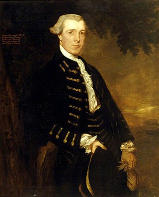
James Modyford Heywood was an English Member of Parliament for Fowey, plantation owner in Jamaica, and Lord of the Admiralty.

References

  1. "Population Usually Resident in Jamaica, by Parish: 2011". Statistical Institute of Jamaica. Retrieved 11 November 2016.
  2. 1 2 Otremba, Eric (2012). "Enlightened Institutions: Science, Plantations, and Slavery in the English Atlantic, 1626-1700". University Digital Conservancy. University of Minnesota.
  3. Mosley, Dr Raul A. (30 March 2015). "Stokes Hall Great House". A Tour of Jamaica's Great Houses, Plantations, & Pens. Retrieved 11 June 2019.
  4. Jamaica Gleaner "Jamaica and the Atlantic Slave Trade (Part II)" Archived 27 September 2007 at the Wayback Machine 26 March 2006
  5. Cundall, Frank (1897). Jamaica cartography; chronological list of the maps of Jamaica in the Library . Kingston: Institute of Jamaica.
  6. Bridges, George Wilson (1828). The annals of Jamaica. London: J. Murray.
  7. 1 2 3 National Archives of Jamaica. lancaster.ac.uk Retrieved 28 June 2019.
  8. 1 2 3 4 Prestwidge, Bill. "Jamaican Parish Reference". Archived from the original on 30 October 2009. Retrieved 24 October 2009.
  9. 1 2 Higman, B. W.; Hudson, B. J. (2009). Jamaican Place Names. Mona, Jamaica: University of the West Indies Press. p. 31. ISBN   978-976-640-306-5.