Peru is a country on the central western coast of South America facing the Pacific Ocean. It lies wholly in the Southern Hemisphere, its northernmost extreme reaching to 1.8 minutes of latitude or about 3.3 kilometres (2.1 mi) south of the equator. Peru shares land borders with Ecuador, Colombia, Brazil, Bolivia, and Chile, with its longest land border shared with Brazil.
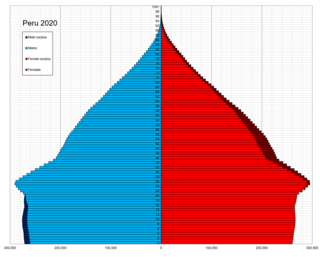
This is a demography of the population of Peru including population density, ethnicity, education level, the health of the populace, economic status, religious affiliations and other aspects of the population.

Lima is the capital and largest city of Peru. It is located in the valleys of the Chillón, Rímac and Lurín Rivers, in the desert zone of the central coastal part of the country, overlooking the Pacific Ocean. The city is considered the political, cultural, financial and commercial center of Peru. Due to its geostrategic importance, the Globalization and World Cities Research Network has categorized it as a "beta" tier city. Jurisdictionally, the metropolis extends mainly within the province of Lima and in a smaller portion, to the west, within the Constitutional Province of Callao, where the seaport and the Jorge Chávez Airport are located. Both provinces have regional autonomy since 2002.

Peru, officially the Republic of Peru, is a country in western South America. It is bordered in the north by Ecuador and Colombia, in the east by Brazil, in the southeast by Bolivia, in the south by Chile, and in the south and west by the Pacific Ocean. Peru is a megadiverse country with habitats ranging from the arid plains of the Pacific coastal region in the west to the peaks of the Andes mountains extending from the north to the southeast of the country to the tropical Amazon basin rainforest in the east with the Amazon River. Peru has a population of over 32 million, and its capital and largest city is Lima. At 1,285,216 km2, Peru is the 19th largest country in the world, and the third largest in South America.

La Libertad is a region in northwestern Peru. Formerly it was known as the Department of La Libertad. It is bordered by the Lambayeque, Cajamarca and Amazonas regions on the north, the San Martín Region on the east, the Ancash and Huánuco regions on the south and the Pacific Ocean on the west. Its capital is Trujillo, which is the nation's third biggest city. The region's main port is Salaverry, one of Peru's largest ports. The name of the region is Spanish for "freedom" or "liberty"; it was named in honor of the Intendencia of Trujillo's proclaiming independence from Spain in 1820 and fighting for that. It is the ninth smallest department in Peru, but it is also its second-most populous department after Piura and its second-most densely populated department after Lambayeque.

Pucallpa is a city in eastern Peru located on the banks of the Ucayali River, a major tributary of the Amazon River. It is the capital of the Ucayali region, the Coronel Portillo Province and the Calleria District.

San Vicente de Cañete, commonly known as San Vicente or Cañete, is a city and capital of the Cañete Province, in southern Lima Region. With a population of 85,533.

Lima is a district of Lima Province in Peru. Lima district is the oldest in Lima Province and as such, vestiges of the city's colonial era remain today in the historic centre of Lima, which was declared a UNESCO World Heritage Site in 1988 and contains the foundational area known as Cercado de Lima.

The provinces of Peru are the second-level administrative subdivisions of the country. They are divided into districts. There are 196 provinces in Peru, grouped into 25 regions, except for Lima Province which does not belong to any region. This makes an average of seven provinces per region. The region with the fewest provinces is Callao (one) and the region with the most is Ancash (twenty).

Lima Province is located in the central coast of Peru and is the only province in the country not belonging to any of the twenty-five regions. Its capital is Lima, which is also the nation's capital.
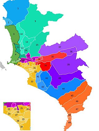
The Lima Metropolitan Area is an area formed by the conurbation of the Peruvian provinces of Lima and Callao. It is the largest of the metropolitan areas of Peru, the seventh largest in the Americas, the fourth largest in Latin America, and among the thirty largest in the world. The conurbation process started to be evident in the 1980s.
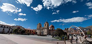
Huancayo is the capital of Junín Region, in the central highlands of Peru.

Paita is a city in northwestern Peru. It is the capital of the Paita Province which is in the Piura Region. It is a leading seaport in the region. Paita is located 1,089 km northwest of the country's capital Lima, and 57 km northwest of the regional capital of Piura. Starting in 2014, the city has considered ideas for separating from the Piura Region, proclaiming itself as the "Miguel Grau Region".

The districts of Peru are the third-level country subdivisions of Peru. They are subdivisions of the provinces, which in turn are subdivisions of the larger regions or departments. There are 1,838 districts in total.

Peru has many languages in use, with its official languages being Spanish, Quechua, Aymara. Spanish has been in the country since it began being taught in the time of José Pardo instead of the country's Native languages, especially the languages in the Andes. In the beginning of the 21st century, it was estimated that in this multilingual country, about 50 very different and popular languages are spoken: which reduces to 44 languages if dialects are considered variants of the same language. The majority of these languages are Indigenous, but the most common language is Spanish, the main language that about 94.4% of the population speaks. Spanish is followed by the country's Indigenous languages, especially all types of Quechua and Aymara (1.4%), who also have co-official status according to Article 48 of the Constitution of Peru, as well as the languages of the Amazon and the Peruvian Sign Language. In urban areas of the country, especially the coastal region, most people are monolingual and only speak Spanish, while in many rural areas of the country, especially in the Amazon, multilingual populations are prevalent.

Yurimaguas is a port town in the Loreto Region of the northeastern Peruvian Amazon. Historically associated with the Mainas missions, the culturally diverse town is affectionately known as the "Pearl of the Huallaga". Yurimaguas is located at the confluence of the majestic Huallaga and Paranapura Rivers in the steamy rainforests of northeastern Peru. It is the capital of both Alto Amazonas Province and Yurimaguas District, and had a population estimated at about 62,903 inhabitants (2017).

Carabayllo is one of the 43 districts of the province Lima in Peru. It is located in the Cono Norte area of the province and was created district by General José de San Martín in August 4, 1821 at which time it was the only district to occupy the area north of the Rímac River up to the province Canta.
Chincha Alta is a Peruvian city located in the Ica Region. A major port at the mouth of the Chincha River, it is the capital of Chincha Province.
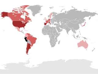
Peruvians are the citizens of Peru. What is now Peru has been inhabited for several millennia by cultures such as the Caral before the Spanish conquest in the 16th century. Peruvian population decreased from an estimated 5–9 million in the 1520s to around 600,000 in 1620 mainly because of infectious diseases carried by the Spanish. Spaniards and Africans arrived in large numbers in 1532 under colonial rule, mixing widely with each other and with Native Peruvians. During the Republic, there has been a gradual immigration of European people. Chinese and Japanese arrived in large numbers at the end of the 19th century.

According to the Organic Law of Regional Governments, the regions are, with the departments, the first-level administrative subdivisions of Peru. Since its 1821 independence, Peru had been divided into departments but faced the problem of increasing centralization of political and economic power in its capital, Lima.


