
The following is a list of rivers in Switzerland :
The following is a list of rivers in Switzerland :
(> 100 km, only the length in Switzerland)

(> 1000 km2, only the area in Switzerland)

Switzerland is drained into four directions:
Rivers that flow into other rivers are sorted by the proximity of their points of confluence to the sea (the lower in the list, the more upstream). Some rivers (e.g. Danube) do not flow through Switzerland themselves, but they are mentioned for having Swiss tributaries. They are given in italics.


The Aare or Aar is a tributary of the High Rhine and the longest river that both rises and ends entirely within Switzerland.

The Rhine is one of the major European rivers. The river begins in the Swiss canton of Graubünden in the southeastern Swiss Alps. It forms part of the Swiss-Liechtenstein, Swiss-Austrian, and Swiss-German borders. After that the Rhine defines much of the Franco-German border, after which it flows in a mostly northerly direction through the German Rhineland. Finally in Germany, the Rhine turns into a predominantly westerly direction and flows into the Netherlands where it eventually empties into the North Sea. It drains an area of 9,973 km2 and its name derives from the Celtic Rēnos. There are also two German states named after the river, North Rhine-Westphalia and Rhineland-Palatinate.

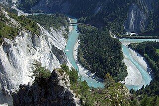
The geography of Switzerland features a mountainous and landlocked country located in Western and Central Europe. Switzerland's natural landscape is marked by its numerous lakes and mountains. It is surrounded by five countries: Austria and Liechtenstein to the east, France to the west, Italy to the south and Germany to the north. Switzerland has a maximum north–south length of 220 kilometres (140 mi) and an east–west length of about 350 kilometres (220 mi).

The Bernese Alps are a mountain range of the Alps, located in western Switzerland. Although the name suggests that they are located in the Berner Oberland region of the canton of Bern, portions of the Bernese Alps are in the adjacent cantons of Valais, Fribourg and Vaud, the latter being usually named Fribourg Alps and Vaud Alps respectively. The highest mountain in the range, the Finsteraarhorn, is also the highest point in the canton of Bern.

The Jura Mountains are a sub-alpine mountain range a short distance north of the Western Alps and mainly demarcate a long part of the French–Swiss border. While the Jura range proper is located in France and Switzerland, the range continues as the Table Jura northeastwards through northern Switzerland and Germany.

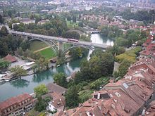
The Limmat is a river in Switzerland. The river commences at the outfall of Lake Zurich, in the southern part of the city of Zürich. From Zürich it flows in a northwesterly direction, continuing a further 35 km it reaches the river Aare. The confluence is located north of the small town of Brugg and shortly after the mouth of the Reuss.
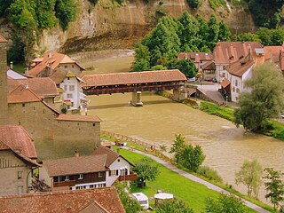
The Reuss is a river in Switzerland. With a length of 164 kilometres (102 mi) and a drainage basin of 3,426 square kilometres (1,323 sq mi), it is the fourth largest river in Switzerland. The upper Reuss forms the main valley of the canton of Uri. The course of the lower Reuss runs from Lake Lucerne to the confluence with the Aare at Brugg and Windisch.
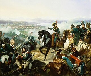
The Second Battle of Zurich was a key victory by the Republican French army in Switzerland led by André Masséna over a Russian force commanded by Alexander Korsakov near Zürich. It broke the stalemate that had resulted from the First Battle of Zurich three months earlier and led to the withdrawal of Russia from the Second Coalition. Most of the fighting took place on both banks of the river Limmat up to the gates of Zürich, and within the city itself. The same days saw a battle between Hotze's Austrians and Soult's French at the River Linth.
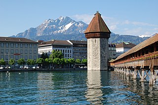
The Sarine or Saane is a major river of Switzerland. It is 128 km (80 mi) long and has a drainage area of 1,892 km2 (731 sq mi). It is a tributary of the Aare.

The Bernese Oberland, sometimes also known as the Bernese Highlands, is the highest and southernmost part of the canton of Bern. It is one of the canton's five administrative regions. It constitutes the Alpine region of the canton and the northern side of the Bernese Alps, including many of its highest peaks, among which the Finsteraarhorn, the highest in both range and canton.

The Swiss Plateau or Central Plateau is one of the three major landscapes in Switzerland, lying between the Jura Mountains and the Swiss Alps. It covers about 30% of the Swiss surface area, and is partly flat but mostly hilly. The average height is between 400 metres (1,300 ft) and 700 metres (2,300 ft) AMSL. It is by far the most densely populated region of Switzerland, the center of economy and important transportation.

Röstigraben is a term used to refer to the cultural boundary between German-speaking and French-speaking parts of Switzerland, the latter known in French as the Suisse romande. There is also the term Polentagraben, referring to the boundary between German-speaking cantons, and the Italian-speaking canton of Ticino.

The Alps form a large mountain range dominating Central Europe, including parts of Italy, France, Switzerland, Liechtenstein, Austria, Slovenia, Germany and Hungary.

The Limmat Valley is a river valley and a region in the cantons of Zürich and Aargau in Switzerland.
Lake Toma in the Swiss canton of Graubünden is generally regarded as the Source of the Rhine. Its outflow is called Rein da Tuma and after a few kilometers, it forms the Vorderrhein/Rein Anteriur. The course of this river is not particularly representative: after about two kilometers, its water is diverted into Curnera reservoir. The water is released at the Tavanase plant and flows into the Rhine at Ilanz. The river begins to be called Rhine in the vicinity of Chur, more specifically, at the confluence of the Vorderrhein and Hinterrhein/Rein Posteriur next to Reichenau in Tamins.

The Battle of Amsteg saw a Republican French division under General of Division Claude Lecourbe face a brigade of Habsburg Austrian soldiers led by General-major Joseph Anton von Simbschen. Lecourbe's offensive began on 14 August when six columns of French infantry advanced on the upper Reuss valley from the north and east. By 16 August, Lecourbe's forces had driven Simbschen's Austrians from the valley and seized control of the strategic Gotthard Pass between Italy and Switzerland.

The Battle of (the) Linth River saw a French division under General of Division Jean-de-Dieu Soult face a force of Austrian, Imperial Russian, and Swiss rebel soldiers led by Feldmarschall-Leutnant Friedrich Freiherr von Hotze in Switzerland. Soult carefully planned and his troops carried out a successful assault crossing of the Linth River between Lake Zurich and the Walensee. Hotze's death early in the action disorganized the Allied defenders who were defeated and forced to retreat, abandoning supplies accumulated for Field Marshal Alexander Suvorov's approaching army. On the same day, General of Division André Masséna's French Army of Helvetia defeated Lieutenant General Alexander Korsakov's Russian army in the Second Battle of Zurich and a French brigade turned back another Austrian force near Mollis. Both Korsakov's Russians and Hotze's survivors, led by Feldmarschall-Leutnant Franz Petrasch withdrew north of the Rhine River.
Major topics | |||||||||
| History |  | ||||||||
| Geography |
| ||||||||
| Politics | |||||||||
| Economy | |||||||||
| Society |
| ||||||||