Some of the Rivers of Hungary include:
Some of the Rivers of Hungary include:
(> 100 km, only the length in Hungary)

(> 1000 km2, only the area in Hungary)
Danube (Duna) - 93,030 km² – 11,7% of total basin

(> 10 m3/s, this list includes not only in Hungary)
Rivers that flow into other rivers are sorted by the proximity of their points of confluence to the sea (the lower in the list, the more upstream).
The rivers in this section are sorted north-west (Austria) to south (Croatia-Serbia).
The rivers in this section are sorted north-west to south-west.
Berettyó, Bodrog, Bodva, Dráva/Drava, Hernád, Fehér-Körös, Fekete-Körös, Ipoly, Kígyós/Plazović, Körös, Körös-ér, Kraszna, Lajta/Leitha, Maros, Mura/Mur, Pinka, Rába/Raab, Sajó, Sebes-Körös, Séd, Sió, Sugovica, Szamos, Szinva, Tisza, Zagyva, Zala, Válicka
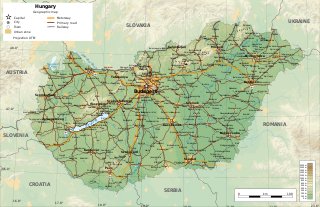
Hungary is a landlocked country in the southern region of East-Central Europe, bordering the Balkans. Situated in the Carpathian Basin, it has a land area of 93,030 square km, measuring about 250 km from north to south and 524 km from east to west. It has 2,106 km of boundaries, shared with Slovakia to the north, Ukraine to the northeast, Romania to the east and southeast, Serbia to the south, Croatia to the southwest, Slovenia to the west and southwest, and Austria to the west.

The Tisza, Tysa or Tisa, is one of the major rivers of Central and Eastern Europe. Once, it was called "the most Hungarian river" because it flowed entirely within the Kingdom of Hungary. Today, it crosses several national borders.
The Drava or Drave, historically known as the Dravis or Dravus, is a river in southern Central Europe. With a length of 710km, 724km including the Sextner Bach source, it is the fifth or sixth longest tributary of the Danube, after the Tisza, Sava, Prut, Mureș and perhaps Siret. The Drava drains an area of about 40154km². Its mean annual discharge is seasonally 500m³/s to 670m³/s. Its source is near the market town of Innichen, in the Puster Valley of South Tyrol, Italy. The river flows eastwards through East Tyrol and Carinthia in Austria into the Styria region of Slovenia. It then turns southeast, passing through northern Croatia and, after merging with its main tributary Mur, forms most of the border between Croatia and Hungary, before it joins the Danube near Osijek.

The Crișul Repede is a river in Bihor County, Crișana, Romania and in southeastern Hungary (Körösvidek). Together with the rivers Crișul Alb and Crișul Negru, it makes up the Three Criș rivers. These are considered the main rivers in the Crișana region of Romania. Historically, when Crișana was recognised as an official region, the Criș rivers were the most important in the region. Its basin size is 9,119 km2 (3,521 sq mi). Its length in Romania is 171 km (106 mi).
The San is a river in southeastern Poland and western Ukraine, a tributary of the river Vistula, with a length of 458 kilometres (285 mi) and a basin area of 16,877 km2.

The Mureș or Maros is a 789-kilometre-long (490 mi) river in Eastern Europe. Its drainage basin covers an area of 30,332 km2 (11,711 sq mi). It originates in the Hășmașu Mare Range in the Eastern Carpathian Mountains, Romania, rising close to the headwaters of the river Olt, and joins the Tisza at Szeged in southeastern Hungary. In Romania, its length is 761 km (473 mi) and its basin size is 27,890 km2 (10,770 sq mi).

The Körös or Criș is a river in eastern Hungary and western Romania. Its length is 128.6 km (79.9 mi) from the confluence of its two source rivers Fehér-Körös and Fekete-Körös to its outflow into the Tisza. Its drainage basin area is 27,537 km2 (10,632 sq mi). It has three source rivers, all of which have their origin in the Apuseni Mountains in Transylvania, Romania: Crișul Alb (Fehér-Körös), Crișul Negru (Fekete-Körös) and Crișul Repede (Sebes-Körös). The confluence of the rivers Fehér-Körös and Fekete-Körös is near the town Gyula. The Körös downstream from Gyula is also called the Kettős-Körös. 37.3 km further downstream, near Gyomaendrőd, the Sebes-Körös joins the Criș/Körös. The section downstream from Gyomaendrőd is also called the Hármas-Körös. The Körös flows into the Tisza River near Csongrád.

The Sajó or Slaná (Slovak) is a river in Slovakia and Hungary.

Kiskőrös is a town in Bács-Kiskun, Hungary. Kiskőrös is situated between the Danube and Tisza rivers at around 46°37′14″N19°17′19″E. Sándor Petőfi, the national poet of Hungary, was born here.
The Zagyva is a river in Hungary. Its length is 179 km, and drains an area of about 5,677 km2. The source is near Salgótarján in Nógrád county. It flows through the towns of Bátonyterenye, Pásztó, Hatvan and Jászberény and flows into the Tisza at Szolnok. Average discharge at Szolnok is 9 m³/s. The Zagyva is the longest river in Hungary that has both its source and its confluence within the country's borders.

The Valea Roșie or Roșia is a river in Romania, Bihor County, right tributary of the Crișul Negru. Its length is 38 km (24 mi) and its basin size is 308 km2 (119 sq mi).

The Barcău or Bereteu is a river which has its origin in Sălaj County, Romania. It is about 167 kilometres (104 mi) long with a watershed area of 5,812 km2 (2,244 sq mi). After crossing Bihor County in Romania and Hajdú-Bihar and Békés County in Hungary, it flows into the Sebes-Körös near Szeghalom. Its length in Romania is 134 km (83 mi).

The hydrology of Hungary, is mostly determined by Hungary's lying in the middle of the Carpathian Basin, half surrounded by the Carpathian Mountains. All parts of the country have some outflow. All surface water gravitates towards its southern center, and from there, is united in the Danube, which flows into the Black Sea. The whole of Hungary lies within the Danube drainage basin.

SMS Körös was the name ship of the Körös-class river monitors built for the Austro-Hungarian Navy. Completed in 1892, the ship was part of the Danube Flotilla, and fought various Allied forces from Belgrade down the Danube to the Black Sea during World War I. After brief service with the Hungarian People's Republic at the end of the war, she was transferred to the newly created Kingdom of Serbs, Croats, and Slovenes, and renamed Morava. She remained in service throughout the interwar period, although budget restrictions meant she was not always in full commission.
Paul from the kindred Geregye was an influential Hungarian baron following the Mongol invasion of 1241. He served as Judge royal twice during the reign of Béla IV of Hungary.

The Nagyrév culture was a Bronze-Age culture that existed in what is now Nagyrév, Hungary. It existed alongside the Vatya culture and Hatvan cultures and was eventually superseded by the latter. The main style of pottery was a one or two handed cup with a tall funnel neck that is made in a black burnished ware.
The Hatvan culture was a Hungarian Bronze Age archaeological culture that succeeded the Nagyrév culture. The earliest identified settlements are located in the Cserehát Hills, later expanding into northern Hungary and the Tisza valley, and the Tiszazug area in Eastern Hungary. The end of Hatvan culture was associated with the expansion of the Ottomány culture.