Lordsburg, New Mexico | |
---|---|
Coordinates: 32°20′38″N108°42′08″W / 32.34389°N 108.70222°W | |
Country | United States |
State | New Mexico |
County | Hidalgo |
Founded | 1880 |
Government | |
• Mayor | Robert Barrera |
Area | |
• Total | 8.43 sq mi (21.82 km2) |
• Land | 8.43 sq mi (21.82 km2) |
• Water | 0.00 sq mi (0.00 km2) |
Elevation | 4,269 ft (1,301 m) |
Population | |
• Total | 2,335 |
• Density | 277.15/sq mi (107.01/km2) |
Time zone | UTC-7 (MST) |
• Summer (DST) | UTC-6 (MDT) |
ZIP codes | 88009, 88045 |
Area code | 575 |
FIPS code | 35-42180 |
GNIS feature ID | 2410872 [2] |
Lordsburg is a city in and the county seat of Hidalgo County, New Mexico, United States. [4] Hidalgo County includes the southern "bootheel" of New Mexico, along the Arizona border. [5] The population was 2,797 at the 2010 census, [6] down from 3,379 in 2000.
Lordsburg was founded in 1880 on the route of the Southern Pacific Railroad. The Continental Divide Trail starts at the Crazy Cook Monument and travels through Lordsburg. [5] Local lore is that Billy the Kid washed dishes in Lordsburg hotel kitchens such as the Stratford Hotel, and La Fonda, the historic "inn at the end of the Santa Fe Trail" during his teenage years. [7]
Lordsburg is the birthplace of the official New Mexico state song, "O Fair New Mexico". [8] It was written by Lordsburg resident Elizabeth Garrett, the blind daughter of famed sheriff Pat Garrett. In 1917, Governor Washington Ellsworth Lindsey signed the legislation making it the official state song. In 1928, John Philip Sousa presented Governor Arthur T. Hannett and the people of New Mexico an arrangement of the state song embracing a musical story of the Indian, the cavalry, the Spanish and the Mexican. [9]
The Lordsburg Municipal Airport (KLSB) began operations in the mid-1920's and was the first airport in New Mexico. Initially the airfield was a cleared parcel of land where pilots could takeoff and land in any direction. Dirt runways were later constructed. [10] [11] In 1927, Lordsburg was one of the stops on Charles Lindbergh's transcontinental Spirit of Saint Louis air tour. [12] In the early 1950s the airport was served by the original Frontier Airlines (1950–1986) which flew DC-3s on a route from El Paso to Phoenix that included stops at Las Cruces, Deming, and Lordsburg, as well as Clifton, Safford, and Tucson, Arizona. [13] In the mid-1970's one runway had to be relocated to permit the construction of Interstate 10 around Lordsburg and a new paved runway was then constructed. [14] The airport is owned by the City of Lordsburg and is southeast, about one mile outside the city limits. [15]
Lordsburg held as many as 1,500 Japanese Americans in a Japanese American internment camp operated by the U.S. Army during World War II. On July 27, 1942, shortly after the Lordsburg Internment Camp was opened, Private First Class Clarence Burleson, a sentry at the facility, allegedly shot two Japanese American internees under questionable circumstances. One of the victims, Hirota Isomura, apparently died instantly. The other, Toshiro Kobata, died before dawn. After a military investigation and court-martial, Burleson was found to have lawfully killed the two men. The camp operated until July 1943. [16] [17] The incident inspired an episode of the new Hawaii 5-0 series, "Ho'oani Makuakane", Episode 4/9 (original air date December 13, 2013).
The camp at Lordsburg also held captured German and Italian soldiers. [18]
For many years, Lordsburg has been a popular rest stop for people traveling to and from the West Coast by car on Interstate 10 and its precursor highway, U.S. Route 80. At 641 miles (1,032 km) from downtown Los Angeles, Lordsburg can comfortably be reached by car in less than one day. As Lordsburg had one of the few motels in the Southwest that would accept black guests (El Paso being a notable exception), it was especially popular with black travelers in the mid-20th century during the end of legal segregation. [12]
There are 12 motels and hotels in Lordsburg. Over 300 rooms are available to guests. [11]
Lordsburg is in northern Hidalgo County, at the intersection of Interstate 10 and U.S. Route 70. I-10 leads east 60 miles (97 km) to Deming and 120 miles (190 km) to Las Cruces, while to the west it leads 155 miles (249 km) to Tucson, Arizona. US 70 follows I-10 to the east out of Lordsburg but leads northwest 153 miles (246 km) to its terminus at Globe, Arizona.
According to the United States Census Bureau, Lordsburg has a total area of 8.4 square miles (21.7 km2), all land. [6]
Lordsburg has a semi-arid climate (Köppen BSk), just avoiding designation as a desert climate (BWk).
Typical for the more southerly and lower elevations of the Intermountain West, summers are extremely hot during the daytime, with maxima above 90 °F or 32.2 °C for over four months on an average of 122 afternoons during a full year. 100 °F or 37.8 °C is exceeded on average during 30 afternoons each year, and the record high of 114 °F (45.6 °C) was set during a notorious southwestern heatwave on June 27, 1994. Humidity in early summer is very low, but increases in late summer due to the monsoon, which, between July and early October brings the majority of the year's limited precipitation. From October temperatures cool off rapidly, and by November most mornings are below 32 °F or 0 °C, but afternoons remains comfortable to warm all through the winter, with only 10.1 afternoons failing to reach 50 °F or 10 °C and only one afternoon every two years not topping freezing. Minima fall below freezing on an average of 108 mornings, but 0 °F or −17.8 °C has been reached only during two exceptional cold waves in January 1962 and December 1978, when the record low of −14 °F or −25.6 °C was reached on the 9th.
Except for the freakishly wet December 1991 when 4.55 inches (115.6 mm) fell from a series of subtropical cyclones, monthly rainfalls above 4.00 inches or 101.6 millimetres are restricted to the monsoon season: the wettest month between 1971 and 2000 was July 1981 with 5.34 inches (135.6 mm). The wettest day has been June 28 of 1981 with 3.00 inches or 76.2 millimetres. Snowfall is very rare; the median for the year is zero and the mean only 3.5 inches or 0.09 metres; with the heaviest snowfall between 1971 and 2000 being of 11.0 inches or 0.28 metres during Christmas and Boxing Days, 1987.
Climate data for Lordsburg 4 SE, New Mexico (1991 to 2020; extremes 1948 to 2001) | |||||||||||||
---|---|---|---|---|---|---|---|---|---|---|---|---|---|
Month | Jan | Feb | Mar | Apr | May | Jun | Jul | Aug | Sep | Oct | Nov | Dec | Year |
Record high °F (°C) | 80 (27) | 85 (29) | 93 (34) | 100 (38) | 106 (41) | 114 (46) | 110 (43) | 109 (43) | 104 (40) | 98 (37) | 86 (30) | 76 (24) | 114 (46) |
Mean daily maximum °F (°C) | 60.5 (15.8) | 65.5 (18.6) | 73.3 (22.9) | 82.2 (27.9) | 90.8 (32.7) | 99.5 (37.5) | 98.6 (37.0) | 96.2 (35.7) | 91.4 (33.0) | 82.4 (28.0) | 70.2 (21.2) | 59.0 (15.0) | 80.8 (27.1) |
Mean daily minimum °F (°C) | 25.2 (−3.8) | 28.2 (−2.1) | 32.8 (0.4) | 37.9 (3.3) | 47.8 (8.8) | 58.1 (14.5) | 65.1 (18.4) | 63.2 (17.3) | 56.1 (13.4) | 43.4 (6.3) | 30.7 (−0.7) | 25.6 (−3.6) | 42.8 (6.0) |
Record low °F (°C) | −9 (−23) | 3 (−16) | 11 (−12) | 12 (−11) | 24 (−4) | 35 (2) | 49 (9) | 42 (6) | 36 (2) | 19 (−7) | 8 (−13) | −14 (−26) | −14 (−26) |
Average rainfall inches (mm) | 0.88 (22) | 0.79 (20) | 0.60 (15) | 0.25 (6.4) | 0.25 (6.4) | 0.34 (8.6) | 2.12 (54) | 2.17 (55) | 1.21 (31) | 0.73 (19) | 0.79 (20) | 1.19 (30) | 11.32 (287.4) |
Average snowfall inches (cm) | 1 (2.5) | 1 (2.5) | 0 (0) | 0 (0) | 0 (0) | 0 (0) | 0 (0) | 0 (0) | 0 (0) | 0 (0) | 0 (0) | 2 (5.1) | 4 (10.1) |
Average rainy days (≥ 0.01 inch) | 4.7 | 4.2 | 4.2 | 1.7 | 2.1 | 2.2 | 8.0 | 7.5 | 4.8 | 4.6 | 2.9 | 4.2 | 51.1 |
Source 1: National Oceanic and Atmospheric Administration [19] | |||||||||||||
Source 2: Weather Atlas [20] |
Census | Pop. | Note | %± |
---|---|---|---|
1920 | 1,325 | — | |
1930 | 2,069 | 56.2% | |
1940 | 3,101 | 49.9% | |
1950 | 3,525 | 13.7% | |
1960 | 3,436 | −2.5% | |
1970 | 3,429 | −0.2% | |
1980 | 3,195 | −6.8% | |
1990 | 2,951 | −7.6% | |
2000 | 3,379 | 14.5% | |
2010 | 2,797 | −17.2% | |
2020 | 2,335 | −16.5% | |
U.S. Decennial Census [21] [3] |
As of the census [22] of 2000, there were 3,379 people (2,398 est. 2019 [23] ), 1,220 households, and 854 families residing in the city. The population density was 403.1 inhabitants per square mile (155.6/km2). There were 1,414 housing units at an average density of 168.7 per square mile (65.1/km2). The racial makeup of the city was 80.70% White, 0.56% African American, 0.77% Native American, 0.50% Asian, 13.97% from other races, and 3.49% from two or more races. Hispanic or Latino of any race were 74.43% of the population.
There were 1,220 households, out of which 36.9% had children under the age of 18 living with them, 46.5% were married couples living together, 18.6% had a female householder with no husband present, and 30.0% were non-families. 27.3% of all households were made up of individuals, and 12.4% had someone living alone who was 65 years of age or older. The average household size was 2.70 and the average family size was 3.31.
In the city, the population was spread out, with 31.9% under the age of 18, 8.5% from 18 to 24, 25.6% from 25 to 44, 18.9% from 45 to 64, and 15.0% who were 65 years of age or older. The median age was 33 years. For every 100 females, there were 94.8 males. For every 100 females age 18 and over, there were 89.4 males.
The median income for a household in the city was $21,036, and the median income for a family was $28,026. Males had a median income of $25,952 versus $18,177 for females. The per capita income for the city was $10,877. About 28.6% of families and 32.7% of the population were below the poverty line, including 47.5% of those under age 18 and 19.3% of those age 65 or over.
Lordsburg is the final destination in Stagecoach , the 9th greatest Western film of all time according to the American Film Institute, starring John Wayne in his breakthrough role as the Ringo Kid, and directed by John Ford. In 1995, this film was deemed "culturally, historically, or aesthetically significant" by the United States Library of Congress and selected for preservation in their National Film Registry. [24]
Lordsburg High School's mascot is the Maverick. Its school colors are orange and black. Students compete in football, volleyball, boys' basketball, girls' basketball, cheer, and boys' and girls' track and field, baseball and softball.
Lordsburg once had two radio stations. During the 1960s KLHS broadcast on 950 kHz AM with 1,000 watts days. This station later moved to Bayard, 55 miles (89 km) northeast of Lordsburg. The FCC later assigned 97.7 to KXKK in the 1980s, now KPSA-FM; this station has since moved to 98.5.
Greyhound Lines maintains a terminal in Lordsburg.
Grant County Airport,(49 miles) northeast of Lordsburg.
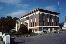
Hidalgo County is the southernmost county of the U.S. state of New Mexico. As of the 2020 census, the population was 4,178. The county seat and largest city is Lordsburg. A bill creating Hidalgo from the southern part of Grant County was passed on February 25, 1919, taking effect at the beginning of 1920. The county was named for the town north of Mexico City where the Treaty of Guadalupe Hidalgo was signed, which in turn was named for Miguel Hidalgo y Costilla, the priest who is known as the "Father of Mexican Independence." The county is located on the Mexico–United States border.
Douglas is a city in Cochise County, Arizona, United States that lies in the north-west to south-east running Sulphur Springs Valley. Douglas has a border crossing with Mexico at Agua Prieta and a history of mining.
Duncan is a town in Greenlee County, Arizona, United States. As of the 2010 census, the population of the town was 696. In 2018 the estimated population was 789.
Parker is the county seat of La Paz County, Arizona, United States, on the Colorado River in Parker Valley. As of the 2020 census, the population of the city was 3,417.
Whiteriver is a census-designated place (CDP) located on the Fort Apache Indian Reservation in Navajo County, Arizona, United States. The population was 4,104 at the 2010 census, making it the largest settlement on the Reservation.
Markleeville is a census-designated place (CDP) and the county seat of Alpine County, California, United States. The population was 191 at the 2020 census, down from 210 at the 2010 census.
Brawley is a city in Imperial County, California, United States within the Imperial Valley.
Elkhart is a city in and the county seat of Morton County, Kansas, United States. As of the 2020 census, the population of the city was 1,888. The south edge of the city is the Kansas-Oklahoma state border, and the city is 8.5 miles (13.7 km) from the Kansas-Colorado border.
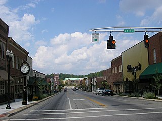
London is a home rule-class city in Laurel County, Kentucky, in the United States. It is the seat of its county. The population was 8,053 at the time of the 2020 census. It is the second-largest city named "London" in the United States and the fourth-largest in the world. It is part of the London, Kentucky micropolitan area. Of the seventeen micropolitan areas in Kentucky, London is the largest; the London micropolitan area's 2010 Census population was 126,368. London is also home to the annual World Chicken Festival that celebrates the life of Colonel Sanders and features the world's largest skillet.
Arthur is a village in, and the county seat of Arthur County, Nebraska, United States. The population was 117 at the 2010 census.
Valentine is a city in Cherry County, Nebraska, United States. The population was 2,737 at the 2010 census. It is the county seat of Cherry County.
Grants is a city in Cibola County, New Mexico, United States. It is located about 78 miles (126 km) west of Albuquerque. The population was 9,163 at the 2020 Census. It is the county seat of Cibola County.
Virden is a village in Hidalgo County, New Mexico, United States. The population was 152 at the 2010 census.
Aztec is a city in, and the county seat of, San Juan County, New Mexico, United States. The city population was 6,126 as of the 2022 population estimate. The Aztec Ruins National Monument is located in Aztec.
Estancia is a town in Torrance County, New Mexico, United States. As of the 2020 census, the town population was 1,242. It is the county seat of Torrance County.
Harbor is an unincorporated community in Curry County, Oregon, United States. It is located across the Chetco River from the city of Brookings. For statistical purposes, the United States Census Bureau has defined Harbor as a census-designated place (CDP). The census definition of the area may not precisely correspond to local understanding of the area with the same name. The population of the CDP was 2,391 at the 2010 census.
Custer is a city in Custer County, South Dakota, United States. The population was 1,919 at the 2020 census. It is the county seat of Custer County.
Hebbronville is a census-designated place (CDP) in and the county seat of Jim Hogg County, Texas, United States. The population was 4,558 at the 2010 census.
Panguitch is a city in and the county seat of Garfield County, Utah, United States. The population was 1,725 at the 2020 census. The name Panguitch comes from a Southern Paiute word meaning “Big Fish,” likely named after the plentiful nearby lakes hosting rainbow trout year-round.
Deming is a city in Luna County, New Mexico, United States, 60 miles (97 km) west of Las Cruces and 35 miles (56 km) north of the Mexican border. The population was 14,758 as of the 2020 census. Deming is the county seat and principal community of Luna County.