Hidalgo County, New Mexico

Last updated

Hidalgo County
Hidalgo County New Mexico Courthouse.jpg
Hidalgo County courthouse in Lordsburg
Map of New Mexico highlighting Hidalgo County.svg
Location within the U.S. state of New Mexico
New Mexico in United States.svg
New Mexico's location within the U.S.
Coordinates: 31°55′N108°43′W / 31.92°N 108.71°W / 31.92; -108.71
CountryFlag of the United States.svg United States
StateFlag of New Mexico.svg  New Mexico
FoundedJanuary 1, 1920
Named for Villa de Guadalupe Hidalgo
Seat Lordsburg
Largest cityLordsburg
Area
  Total3,446 sq mi (8,930 km2)
  Land3,437 sq mi (8,900 km2)
  Water9.1 sq mi (24 km2)  0.3%
Population
 (2020)
  Total4,178
  Density1.2/sq mi (0.47/km2)
Time zone UTC−7 (Mountain)
  Summer (DST) UTC−6 (MDT)
Congressional district 2nd
Website www.hidalgocounty.org

Hidalgo County (Spanish : Condado de Hidalgo) is the southernmost county of the U.S. state of New Mexico. As of the 2020 census, the population was 4,178. [1] The county seat and largest city is Lordsburg. [2] A bill creating Hidalgo from the southern part of Grant County was passed on February 25, 1919, taking effect at the beginning of 1920. [3] [4] The county was named for the town north of Mexico City where the Treaty of Guadalupe Hidalgo was signed, [5] which in turn was named for Miguel Hidalgo y Costilla, the priest who is known as the "Father of Mexican Independence." The county is located on the Mexico–United States border.

Contents

Geography

According to the U.S. Census Bureau, the county has a total area of 3,446 square miles (8,930 km2), of which 3,437 square miles (8,900 km2) is land and 9.1 square miles (24 km2) (0.3%) is water. [6] The southern part of the county, the part bounded on the east and south by Mexico, is known as the Bootheel.

Adjacent counties and municipios

National protected areas

Demographics

Historical population
CensusPop.Note
1920 4,338
1930 5,02315.8%
1940 4,821−4.0%
1950 5,0955.7%
1960 4,961−2.6%
1970 4,734−4.6%
1980 6,04927.8%
1990 5,958−1.5%
2000 5,932−0.4%
2010 4,894−17.5%
2020 4,178−14.6%
U.S. Decennial Census [7]
1790-1960 [8] 1900-1990 [9]
1990-2000 [10] 2010 [11]

2000 census

As of the 2000 census, [12] there were 5,932 people in the county, organized into 2,152 households, and 1,542 families. The population density was 1 person per square mile (0.39 person/km2). There were 2,848 housing units at an average density of 1 units per square mile (0.39/km2). The racial makeup of the county was 42% White and about 55% of the population was Hispanic.

Size of family households: 592 2-persons, 341 3-persons, 316 4-persons, 165 5-persons, 83 6-persons, 48 7-or-more-persons. The average household size was 2.7 and the average family size was 3.29. In non-family households, there were 684 with 314 male householders (286 living alone), 293 female householders (262 living alone), and 77 non-relatives. In group quarters, there were 85 (all institutionalized).

In the county, the population was spread out, with 31.70% under the age of 18, 7.80% from 18 to 24, 25.20% from 25 to 44, 21.70% from 45 to 64, and 13.60% who were 65 years of age or older. The median age was 35 years. For every 100 females there were 99.60 males. For every 100 females age 18 and over, there were 97.00 males.

The median income for a household in the county was $31,286. The per capita income for the county was $12,431. 27.8% of the population was below the poverty line. Out of the total population, 38.90% of those under the age of 18 and 17.00% of those 65 and older were living below the poverty line. Unemployment rate in April 2010 was 7.6%.

2010 census

As of the 2010 census, there were 4,894 people, 1,936 households, and 1,286 families residing in the county. [13] The population density was 1.4 inhabitants per square mile (0.54/km2). There were 2,393 housing units at an average density of 0.7 per square mile (0.27/km2). [14] The racial makeup of the county was 85.3% white, 0.8% American Indian, 0.6% black or African American, 0.5% Asian, 11.0% from other races, and 1.8% from two or more races. Those of Hispanic or Latino origin made up 56.6% of the population. [13] The largest ancestry groups were: [15]

  • 50.3% Mexican
  • 15.2% German
  • 10.0% English
  • 6.0% Irish
  • 4.4% Dutch
  • 3.6% American
  • 2.1% Scottish
  • 2.0% Italian
  • 1.7% Swedish
  • 1.4% Norwegian
  • 1.0% Polish

Of the 1,936 households, 33.4% had children under the age of 18 living with them, 46.4% were married couples living together, 14.2% had a female householder with no husband present, 33.6% were non-families, and 29.1% of all households were made up of individuals. The average household size was 2.49 and the average family size was 3.09. The median age was 40.9 years. [13]

The median income for a household in the county was $36,733 and the median income for a family was $41,594. Males had a median income of $43,531 versus $23,482 for females. The per capita income for the county was $17,451. About 20.6% of families and 22.6% of the population were below the poverty line, including 32.3% of those under age 18 and 15.0% of those age 65 or over. [16]

Communities

City

Village

Census-designated places

Unincorporated communities

Ghost towns

Politics

Hidalgo has historically been a swing county, going for the winner every time since 1928, except for 1968 and 2020, where it went for Hubert Humphrey and Donald Trump respectively.

United States presidential election results for Hidalgo County, New Mexico [17]
Year Republican Democratic Third party
No.%No.%No.%
2020 1,12056.74%82341.69%311.57%
2016 91048.61%78441.88%1789.51%
2012 89946.46%99551.42%412.12%
2008 93647.98%99350.90%221.13%
2004 1,08155.04%86143.84%221.12%
2000 95452.02%83945.75%412.24%
1996 78940.42%94348.31%22011.27%
1992 87137.62%99542.98%44919.40%
1988 1,10054.46%90144.60%190.94%
1984 1,28259.32%86039.80%190.88%
1980 1,05953.19%84042.19%924.62%
1976 89148.56%93851.12%60.33%
1972 1,05163.43%56233.92%442.66%
1968 60639.25%67843.91%26016.84%
1964 62838.43%99560.89%110.67%
1960 75045.65%88954.11%40.24%
1956 79050.51%77149.30%30.19%
1952 78150.58%75749.03%60.39%
1948 37430.11%85969.16%90.72%
1944 36731.26%80768.74%00.00%
1940 51632.97%1,04967.03%00.00%
1936 32622.34%1,11576.42%181.23%
1932 29920.48%1,13177.47%302.05%
1928 56152.38%50947.53%10.09%
1924 26128.19%47651.40%18920.41%
1920 44344.39%55155.21%40.40%

See also

Related Research Articles

<span class="mw-page-title-main">Greenlee County, Arizona</span> County in Arizona, United States

Greenlee County is a county in the southeastern part of the U.S. state of Arizona. As of the 2020 census, the population was 9,563, making it Arizona's least populous county. The county seat is Clifton.

<span class="mw-page-title-main">San Juan County, New Mexico</span> County in New Mexico, United States

San Juan County is located in the U.S. state of New Mexico. As of the 2020 census, the population was 121,661 making it the fifth-most populous county in New Mexico. Its county seat is Aztec. The county was created in 1887.

<span class="mw-page-title-main">Roosevelt County, New Mexico</span> County in New Mexico, United States

Roosevelt County is a county located in the U.S. state of New Mexico. As of the 2020 census, the population was 19,191. Its county seat is Portales. The county was created in 1903 from Chaves and Guadalupe counties and named for the then-current President of the United States, Theodore Roosevelt. The county's eastern border is the Texas state line.

<span class="mw-page-title-main">Quay County, New Mexico</span> County in New Mexico, United States

Quay County is a county in the state of New Mexico. As of the 2020 U.S. census, the population was 8,746. Its county seat is Tucumcari. The county was named for Pennsylvania senator Matthew Quay, who supported statehood for New Mexico. Its eastern border is the Texas state line, approximately 103.04 degrees west longitude.

<span class="mw-page-title-main">Luna County, New Mexico</span> County in New Mexico, United States

Luna County(Spanish: Condado de Luna) is a county located in the U.S. state of New Mexico. As of the 2020 census, the population was 25,427. Its county seat is Deming. This county abuts the Mexican border. Luna County comprises the Deming, NM Micropolitan Statistical Area.

<span class="mw-page-title-main">Harding County, New Mexico</span> County in New Mexico, United States

Harding County is a county in the U.S. state of New Mexico. As of the 2020 census, the population was 657, making it the least populous county in the state, and the 13th-smallest county by population in the United States. Its county seat is Mosquero. The county is named for United States President Warren G. Harding, and was created on the day of his inauguration as president on March 4, 1921, making him the most recent president to have a county in any state named after him.

<span class="mw-page-title-main">Guadalupe County, New Mexico</span> County in New Mexico, United States

Guadalupe County is a county in the U.S. state of New Mexico. As of the 2020 census, the population was 4,452. Its county seat is Santa Rosa.

<span class="mw-page-title-main">Grant County, New Mexico</span> County in New Mexico, United States

Grant County is a county located in the U.S. state of New Mexico. At the 2020 census, the population was 28,185. Its county seat is Silver City. The county was founded in 1868 and named for Ulysses S. Grant, the 18th President of the United States.

<span class="mw-page-title-main">Chaves County, New Mexico</span> County in New Mexico, United States

Chaves County is a county in New Mexico, United States. As of the 2020 census, the population was 65,157. Its county seat is Roswell. Chaves County was named for Colonel Jose Francisco Chaves, a military leader there during the Civil War and later in Navajo campaigns. The county was created by the New Mexico Territorial Legislature on February 25, 1889, out of land from Lincoln County.

<span class="mw-page-title-main">Hidalgo, Illinois</span> Village in Illinois, United States

Hidalgo is a village in Jasper County, Illinois, United States. The population was 106 at the 2010 census.

<span class="mw-page-title-main">Lordsburg, New Mexico</span> City in New Mexico, United States

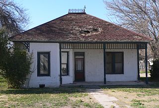
Lordsburg is a city in and the county seat of Hidalgo County, New Mexico, United States. Hidalgo County includes the southern "bootheel" of New Mexico, along the Arizona border. The population was 2,797 at the 2010 census, down from 3,379 in 2000.

<span class="mw-page-title-main">Virden, New Mexico</span> Village in New Mexico, United States

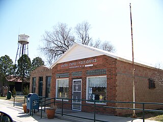
Virden is a village in Hidalgo County, New Mexico, United States. The population was 152 at the 2010 census. Growth and new construction is almost non-existent, but together with the Arizona sister-village of Duncan 7 miles (11 km) to the west, the consolidated area might experience minimal population and infrastructural growth in the next decade.

<span class="mw-page-title-main">Lovington, New Mexico</span> City in New Mexico, United States

Lovington is a city in, and the county seat of, Lea County, New Mexico, United States. The population was 11,009 at the 2010 census, up from 9,471 in 2000.

<span class="mw-page-title-main">Berea, South Carolina</span> CDP in South Carolina, United States

Berea is a census-designated place (CDP) in Greenville County, South Carolina, United States. The population was 14,295 at the 2010 census. It is part of the Greenville–Mauldin–Easley Metropolitan Statistical Area.

<span class="mw-page-title-main">Edcouch, Texas</span> City in Texas

Edcouch is a city in Hidalgo County, Texas, United States. The population was 3,161 at the 2010 census. It is part of the McAllen–Edinburg–Mission and Reynosa–McAllen metropolitan areas. The town was founded in 1927 and named for Edward Couch, landowner and banker.

<span class="mw-page-title-main">Hidalgo, Texas</span> City in Texas, United States

Hidalgo is a city in Hidalgo County, Texas, United States. The population was 11,198 at the 2010 census, and in 2019 the estimated population was 14,183.

<span class="mw-page-title-main">Muniz, Texas</span> Census-designated place in Texas

Muniz is a census-designated place (CDP) in Hidalgo County, Texas, United States. The population was 1,370 at the 2010 United States Census. It is part of the McAllen–Edinburg–Mission Metropolitan Statistical Area.

<span class="mw-page-title-main">Progreso Lakes, Texas</span> City in Texas

Progreso Lakes is a city in Hidalgo County, Texas, United States. The population was 240 at the 2010 United States Census. The city, incorporated in 1979, is centered on Lion and Moon Lakes, two resacas or ox-bow lakes.

<span class="mw-page-title-main">San Carlos, Texas</span> Census-designated place in Texas

San Carlos is a community and census-designated place (CDP) in Hidalgo County, Texas. The population was 3,130 at the 2010 United States Census. It is part of the McAllen–Edinburg–Mission Metropolitan Statistical Area.

<span class="mw-page-title-main">De Baca County, New Mexico</span> County in New Mexico, United States

De Baca County is a county in the U.S. state of New Mexico. As of the 2020 census, the population was 1,698, making it New Mexico's second-least populous county. Its county seat is Fort Sumner. The county is named for Ezequiel Cabeza De Baca, the second elected Governor of New Mexico.

References

  1. "Hidalgo County, New Mexico". United States Census Bureau . Retrieved July 3, 2023.
  2. "Find a County". National Association of Counties. Archived from the original on May 31, 2011. Retrieved June 7, 2011.
  3. "County History". Hidalgo County, NM. Retrieved January 2, 2015.
  4. "New Mexico: Consolidated Chronology of State and County Boundaries". New Mexico Atlas of Historical County Boundaries. The Newberry Library. 2007. Archived from the original on August 22, 2016. Retrieved January 1, 2015.
  5. Herrera, Mary (Secretary of State) (2008) New Mexico Blue Book 2007-2008 Office of the Secretary of State, Santa Fe, New Mexico, page 226
  6. "2010 Census Gazetteer Files". United States Census Bureau. August 22, 2012. Archived from the original on January 1, 2015. Retrieved January 2, 2015.
  7. "U.S. Decennial Census". United States Census Bureau. Retrieved January 2, 2015.
  8. "Historical Census Browser". University of Virginia Library. Archived from the original on August 11, 2012. Retrieved January 2, 2015.
  9. "Population of Counties by Decennial Census: 1900 to 1990". United States Census Bureau. Retrieved January 2, 2015.
  10. "Census 2000 PHC-T-4. Ranking Tables for Counties: 1990 and 2000" (PDF). United States Census Bureau. Archived (PDF) from the original on March 27, 2010. Retrieved January 2, 2015.
  11. "State & County QuickFacts". United States Census Bureau. Archived from the original on June 6, 2011. Retrieved September 29, 2013.
  12. "U.S. Census website". United States Census Bureau . Retrieved January 31, 2008.
  13. 1 2 3 "DP-1 Profile of General Population and Housing Characteristics: 2010 Demographic Profile Data". United States Census Bureau. Archived from the original on February 13, 2020. Retrieved January 24, 2016.
  14. "Population, Housing Units, Area, and Density: 2010 - County". United States Census Bureau. Archived from the original on February 13, 2020. Retrieved January 24, 2016.
  15. "DP02 SELECTED SOCIAL CHARACTERISTICS IN THE UNITED STATES – 2006-2010 American Community Survey 5-Year Estimates". United States Census Bureau. Archived from the original on February 13, 2020. Retrieved January 24, 2016.
  16. "DP03 SELECTED ECONOMIC CHARACTERISTICS – 2006-2010 American Community Survey 5-Year Estimates". United States Census Bureau. Archived from the original on February 13, 2020. Retrieved January 24, 2016.
  17. Leip, David. "Dave Leip's Atlas of U.S. Presidential Elections". uselectionatlas.org. Retrieved April 1, 2018.

31°55′N108°43′W / 31.92°N 108.71°W / 31.92; -108.71