Hobbs, New Mexico

Last updated

Hobbs, New Mexico
City
Motto: 
"It All Happens Here"
Lea County New Mexico Incorporated and Unincorporated areas Hobbs Highlighted.svg
Location of Hobbs, New Mexico
Usa edcp location map.svg
Red pog.svg
Hobbs, New Mexico
Location in the United States
Coordinates: 32°43′41″N103°09′36″W / 32.72806°N 103.16000°W / 32.72806; -103.16000 [1]
CountryUnited States
State New Mexico
County Lea
Government
  MayorSam Cobb
  City ManagerManny Gomez
Area
[2]
  Total26.44 sq mi (68.47 km2)
  Land26.40 sq mi (68.39 km2)
  Water0.03 sq mi (0.09 km2)
Elevation
[1]
3,642 ft (1,110 m)
Population
 (2020) [3]
  Total40,508
  Density1,534.16/sq mi (592.35/km2)
Time zone Mountain (MST)
  Summer (DST) UTC−6 (MDT)
ZIP codes
88240-88242
Area code 575
FIPS code 35-32520
GNIS feature ID2410771 [1]
Website www.hobbsnm.org

Hobbs is a city in Lea County, New Mexico, United States. Its population was 40,508 at the 2020 census, [4] increasing from 34,122 in 2010.

Contents

Hobbs is the principal city of the Hobbs, New Mexico micropolitan statistical area, which includes all of Lea County.

History

Hobbs was founded in 1907 when James Isaac Hobbs (1852–1923) established a homestead and named the settlement. [5] In 1910, the Hobbs post office opened, with James Hobbs as the first postmaster. [6] By 1911, about 25 landowners lived in Hobbs. [7]

The small, isolated settlement expanded rapidly following the discovery of oil by the Midwest Oil Company in 1927. A refinery was built the following year, and in 1929, the town of Hobbs was officially incorporated. [8] At the peak of this oil boom, over 12,000 people lived in Hobbs. When the Great Depression hit, oil prices dropped and the population fell to only about 3,000 in 1931. A few years later, though, activity picked up in the oilfields and the population climbed to about 14,000 in 1940. [7]

On June 23, 1938, seven local men were killed and five more injured when an explosive charge used in oil drilling detonated prematurely. [9]

Following the outbreak of World War II, Hobbs Army Airfield was built north of town in 1942. In 1948, the city bought the air base and converted it into the Hobbs Industrial Air Park, which is still used for soaring competitions.

The first college in Hobbs opened in 1956. It was initially the First Baptist College, and in 1962, it became the College of the Southwest. The name was changed again to University of the Southwest in 2008. A second college, New Mexico Junior College, opened in 1966.

An ordinance was passed in Hobbs in November 2022 to prevent abortion clinics from operating. [10]

Geography

Hobbs is in eastern Lea County, less than 4 mi (6 km) west of the Texas border. U.S. Routes 62/180 pass through the city, leading east 29 mi (47 km) to Seminole, Texas, and west 69 mi (111 km) to Carlsbad. State Road 18 also passes through Hobbs, leading northwest 21 mi (34 km) to Lovington, the Lea county seat, and south 61 mi (98 km) to Kermit, Texas.

According to the United States Census Bureau, the city of Hobbs has a total area of 26.4 square miles (68.5 km2), of which 0.04 square miles (0.1 km2), or 0.14%, is covered by water. [11] Land in the city drains either east to Seminole Draw or southeast to Monument Draw, both of which are tributaries of Mustang Draw in Texas and ultimately part of the Colorado River watershed.

Climate

Hobbs, like many parts of eastern New Mexico, has a semiarid climate (Köppen climate classification BSk). [12] The city experiences hot summers and chilly winters. With around 70% of precipitation coming in the high solar half of the year, Hobbs may also be defined as a dry-winter humid subtropical climate (Köppen climate classification Cwa).

Climate data for Hobbs, New Mexico, 1991–2020 normals, extremes 1913–2022
MonthJanFebMarAprMayJunJulAugSepOctNovDecYear
Record high °F (°C)83
(28)
87
(31)
95
(35)
98
(37)
107
(42)
114
(46)
110
(43)
108
(42)
109
(43)
98
(37)
89
(32)
84
(29)
114
(46)
Mean maximum °F (°C)73.1
(22.8)
77.5
(25.3)
84.4
(29.1)
90.7
(32.6)
97.9
(36.6)
104.1
(40.1)
102.6
(39.2)
100.9
(38.3)
97.2
(36.2)
90.6
(32.6)
79.7
(26.5)
71.8
(22.1)
105.7
(40.9)
Mean daily maximum °F (°C)55.1
(12.8)
60.7
(15.9)
68.5
(20.3)
77.1
(25.1)
85.3
(29.6)
93.4
(34.1)
94.1
(34.5)
92.0
(33.3)
84.6
(29.2)
76.0
(24.4)
63.6
(17.6)
55.7
(13.2)
75.5
(24.2)
Daily mean °F (°C)42.3
(5.7)
46.8
(8.2)
54.0
(12.2)
62.3
(16.8)
71.3
(21.8)
79.2
(26.2)
81.4
(27.4)
79.9
(26.6)
72.7
(22.6)
62.9
(17.2)
50.9
(10.5)
43.1
(6.2)
62.2
(16.8)
Mean daily minimum °F (°C)29.6
(−1.3)
33.0
(0.6)
39.5
(4.2)
47.5
(8.6)
57.3
(14.1)
65.1
(18.4)
68.7
(20.4)
67.7
(19.8)
60.7
(15.9)
49.7
(9.8)
38.1
(3.4)
30.5
(−0.8)
48.9
(9.4)
Mean minimum °F (°C)16.7
(−8.5)
18.7
(−7.4)
23.8
(−4.6)
32.5
(0.3)
42.7
(5.9)
56.1
(13.4)
61.3
(16.3)
60.8
(16.0)
48.4
(9.1)
34.1
(1.2)
22.8
(−5.1)
16.4
(−8.7)
12.2
(−11.0)
Record low °F (°C)−7
(−22)
−2
(−19)
1
(−17)
17
(−8)
27
(−3)
37
(3)
47
(8)
45
(7)
35
(2)
12
(−11)
4
(−16)
−1
(−18)
−7
(−22)
Average precipitation inches (mm)0.50
(13)
0.53
(13)
0.63
(16)
0.76
(19)
1.91
(49)
1.27
(32)
1.74
(44)
2.06
(52)
2.46
(62)
0.87
(22)
0.53
(13)
0.51
(13)
13.77
(348)
Average snowfall inches (cm)0.9
(2.3)
0.2
(0.51)
0.0
(0.0)
0.1
(0.25)
0.0
(0.0)
0.0
(0.0)
0.0
(0.0)
0.0
(0.0)
0.0
(0.0)
0.1
(0.25)
0.0
(0.0)
0.5
(1.3)
1.8
(4.61)
Average precipitation days (≥ 0.01 in)2.51.61.72.03.54.34.15.25.53.02.01.837.2
Average snowy days (≥ 0.1 in)0.40.20.00.00.00.00.00.00.00.00.00.30.9
Source 1: NOAA [13]
Source 2: National Weather Service [14]

Demographics

Historical population
CensusPop.Note
1930 598
1940 10,6191,675.8%
1950 13,87530.7%
1960 26,27589.4%
1970 26,025−1.0%
1980 29,15312.0%
1990 29,115−0.1%
2000 28,657−1.6%
2010 34,12219.1%
2020 40,50818.7%
U.S. Decennial Census [15] [3]

2020 census

Hobbs Racial Composition [16]
RaceNum.Perc.
White 11,51528.4%
Black or African American 2,0585.1%
Native American 3120.8%
Asian 4911.2%
Pacific Islander 17<0.1%
Other/mixed 1,0392.6%
Hispanic or Latino 25,07661.9%

As of the 2020 United States Census, 40,508 people, 12,028 households, and 8,572 families resided in the city.

2010 census

As of 2010, 33,405 people, 10,040 households, and 7,369 families were residing in the city. The population density was 1,514.0 inhabitants per square mile (584.6/km2). The 11,968 housing units averaged 632.3 per mi2 (244.1/km2). The racial makeup of the city was 63.5% White, 6.8% African American, 1.1% Native American, 0.4% Asian, 24.5% from other races, and 3.7% from two or more races. Hispanics or Latinos of any race were 42.18% of the population.

Of the 10,040 households, 39.8% had children under 18 living with them, 54.1% were married couples living together, 14.6% had a female householder with no husband present, and 26.6% were not families. About 23.4% of all households were made up of individuals, and 10.1% had someone living alone who was 65 or older. The average household size was 2.72, and the average family size was 3.22.

In the city, the age distribution was 30.4% under 18, 10.3% from 18 to 24, 28.0% from 25 to 44, 19.4% from 45 to 64, and 11.9% who were 65 or older. The median age was 32 years. For every 100 females, there were 100.2 males. For every 100 females age 18 and over, there were 99.2 males.

The median income for a household in the city was $28,100, and for a family was $33,017. Males had a median income of $31,352 versus $20,841 for females. The per capita income for the city was $14,209. About 20.2% of families and 24.2% of the population were below the poverty line, including 32.3% of those under age 18 and 15.5% of those age 65 or over.

Economy

The largest industries in Hobbs are mining/quarrying and oil and gas extraction, followed by retail trade and educational services. [17] Hobbs is also home to Zia Park, a racetrack, hotel and casino with over 750 slot machines and table games. [18]

Arts and culture

Sign in Hobbs Hobbs NM (35751087780).jpg
Sign in Hobbs

Located in Hobbs are the headquarters of the Soaring Society of America and Zia Park Casino, Hotel, and Racetrack, which offers live and simulcast racing, casino games, dining, and a 154-room hotel. The property is owned and operated by Penn National Gaming, Inc. [19]

Transportation

Highways

Railroad

The Texas & New Mexico Railway provides freight service.

Airport

Lea County Regional Airport serves Hobbs with one commercial passenger airline flying to it.

Education

Hobbs Municipal Schools is the local school district.

Notable people

• Ray Birmingham, national champion collegiate baseball coach.

See also

Related Research Articles

<span class="mw-page-title-main">Luna County, New Mexico</span> County in New Mexico, United States

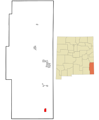
Luna County(Spanish: Condado de Luna) is a county located in the U.S. state of New Mexico. As of the 2020 census, the population was 25,427. Its county seat is Deming. This county abuts the Mexican border. Luna County comprises the Deming, NM Micropolitan Statistical Area.

<span class="mw-page-title-main">Lea County, New Mexico</span> County in New Mexico, United States

Lea County is a county located in the U.S. state of New Mexico. As of the 2020 census, its population was 74,455.

<span class="mw-page-title-main">Eddy County, New Mexico</span> County in New Mexico, United States

Eddy County is a county located in the U.S. state of New Mexico. As of the 2020 census, the population was 62,314. Its county seat and largest city is Carlsbad. The county was created in 1891 and later organized in 1892. It is north of the Texas state line.

<span class="mw-page-title-main">Arlington, Texas</span> City in Texas, United States

Arlington is a city in Tarrant County, Texas, United States. It is part of the Mid-Cities region of the Dallas–Fort Worth–Arlington metropolitan statistical area, and is a principal city of the metropolis and region. The city had a population of 394,266 in 2020, making it the second-largest city in the county after Fort Worth and the third-largest city in the metropolitan area, after Dallas and Fort Worth. Arlington is the 50th-most populous city in the United States, the seventh-most populous city in the state of Texas, and the largest city in the state that is not a county seat.

<span class="mw-page-title-main">Lakeside, California</span> Census designated place in California, United States

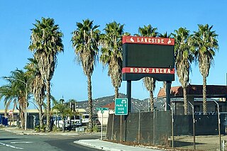
Lakeside is a census-designated place (CDP) in the East County region of San Diego County, California. The population was 21,152 at the 2020 census, up from 20,648 as of the 2010 census.

<span class="mw-page-title-main">Cimarron, New Mexico</span> Village in New Mexico, United States

Cimarron is a village in Colfax County, New Mexico, United States, which sits on the eastern slopes of the Sangre de Cristo Mountains. The population was 792 at the 2020 census, making it the fourth most populous municipality in Colfax County.

<span class="mw-page-title-main">Clovis, New Mexico</span> City in the United States

Clovis is a city in and the county seat of Curry County, New Mexico. The city had a population of 37,775 as of the 2010 census, and a 2020 census population of 38,567. Clovis is located in the New Mexico portion of the Llano Estacado, in the eastern part of the state.

<span class="mw-page-title-main">Texico, New Mexico</span> City in New Mexico, United States

Texico is a city in Curry County, New Mexico, United States. Its population was 1,130 at the 2010 census. The city is located on the Texas-New Mexico border with the town of Farwell across the border.

<span class="mw-page-title-main">Sunland Park, New Mexico</span> City in New Mexico, United States

Sunland Park is a city in southern Doña Ana County, New Mexico, United States, on the borders of Texas and the Mexican state of Chihuahua, with Ciudad Juárez adjoining it on the south and El Paso, Texas, on the east. The community of Santa Teresa adjoins it on the northwest. The population of Sunland Park was 14,106 at the 2010 census and was estimated at 17,978 by the United States Census Bureau in 2019. Though it lies adjacent to El Paso, being in Doña Ana County makes it a part of the Las Cruces metropolitan statistical area. Las Cruces is 42 miles (68 km) to the north.

<span class="mw-page-title-main">Carlsbad, New Mexico</span> City in New Mexico, United States

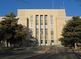
Carlsbad is a city in and the county seat of Eddy County, New Mexico, United States. As of the 2020 census, the city population was 32,238. Carlsbad is centered at the intersection of U.S. Routes 62/180 and 285, and is the principal city of the Carlsbad-Artesia Micropolitan Statistical Area, which has a total population of 62,314. Located in the southeastern part of New Mexico, Carlsbad straddles the Pecos River and sits at the eastern edge of the Guadalupe Mountains.

<span class="mw-page-title-main">Eunice, New Mexico</span> City in New Mexico, United States

Eunice is a city in Lea County, New Mexico, United States. The population was 2,922 at the 2010 census.

<span class="mw-page-title-main">Jal, New Mexico</span> City in New Mexico, United States

Jal is a small city located in Lea County, New Mexico, United States. It is New Mexico's south-easternmost city, and shares a border with Texas to the east and south. The population was 2,047 at the 2010 census. Jal is historically important in the natural gas industry, from the early 1900s to the present day.

<span class="mw-page-title-main">Lovington, New Mexico</span> City in New Mexico, United States

Lovington is a city in, and the county seat of, Lea County, New Mexico, United States. The population was 11,009 at the 2010 census, up from 9,471 in 2000.

<span class="mw-page-title-main">Tucumcari, New Mexico</span> City in the United States

Tucumcari is a city in and the county seat of Quay County, New Mexico, United States. The population was 5,278 at the 2020 census. Tucumcari was founded in 1901, two years before Quay County was established.

<span class="mw-page-title-main">Zia Pueblo, New Mexico</span> CDP in New Mexico, United States

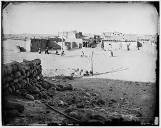
Zia Pueblo is a census-designated place (CDP) in Sandoval County, New Mexico, United States. The population was 646 at the 2000 census, with 310 males and 336 females. The pueblo after which the CDP is named is included within the CDP; it is listed on the National Register of Historic Places.

<span class="mw-page-title-main">Gainesville, Texas</span> City in Texas, United States

Gainesville is a city in and the county seat of Cooke County, Texas, United States. Its population was 17,394 at the 2020 census. It is part of the Texoma region and is an important Agri-business center.

<span class="mw-page-title-main">Eastland, Texas</span> City in Texas, United States

Eastland is a city in Eastland County, Texas, United States. Its population was 3,960 at the 2010 census. It is the county seat of Eastland County.

<span class="mw-page-title-main">La Porte, Texas</span> City in Texas, United States

La Porte is a city in Harris County, Texas, United States, within the Bay Area of the Houston–Sugar Land–Baytown metropolitan area. As of the 2020 census, the city population was 35,124. La Porte is the fourth-largest incorporated city in Harris County.

<span class="mw-page-title-main">Westbrook, Texas</span> City in Texas, United States

Westbrook is a city in Mitchell County, Texas, United States. The population was 203 at the 2000 census.

<span class="mw-page-title-main">Graham, Texas</span> City in Texas, United States

Graham is the county seat and largest city of Young County. As of the 2020 U.S. Census, it has a population of 8,750.

References

  1. 1 2 3 U.S. Geological Survey Geographic Names Information System: Hobbs, New Mexico
  2. "ArcGIS REST Services Directory". United States Census Bureau. Retrieved October 12, 2022.
  3. 1 2 "Census Population API". United States Census Bureau. Retrieved October 12, 2022.
  4. "Total Population: 2010 Census DEC Summary File 1 (P1), Hobbs city, New Mexico". data.census.gov. U.S. Census Bureau. Retrieved May 6, 2020.
  5. Hellmann, Paul T. (February 14, 2006). Historical Gazetteer of the United States. Routledge. p. 741. ISBN   1-135-94859-3.
  6. "Lea County". Jim Forte Postal History. Retrieved April 16, 2015.
  7. 1 2 [Sholin, Terry M. (January 3, 2001). "History of Hobbs". Hobbs New Sun. Hobbs. Archived from the original on August 14, 2015. Retrieved September 15, 2015.
  8. Archuletta, Phil T.; Holden, Sharyl (2004). Traveling New Mexico: A Guide to the Historical and State Park Markers. Sunstone Press. p. 152. ISBN   978-1-61139-117-6.
  9. "SEVEN KILLED, FIVE HURT IN NITRO BLAST IN NEW MEXICO". The Helena Independent. Associated Press. June 23, 1938. Retrieved June 20, 2020.
  10. Brooks, Brad (November 8, 2022). "New Mexico city passes ordinance to block abortion clinics from operating". Reuters . Retrieved November 8, 2022.
  11. "U.S. Gazetteer Files: 2019: Places: New Mexico". U.S. Census Bureau Geography Division. Retrieved May 6, 2020.
  12. http://1.bp.blogspot.com/-AnOY3bX30oI/TZvUMicLbUI/AAAAAAAAABg/J5l2PgBA2Cc/s1600/climatemapusa2yv3.png [ bare URL image file ]
  13. "U.S. Climate Normals Quick Access – Station: Hobbs, NM". National Oceanic and Atmospheric Administration. Retrieved April 8, 2023.
  14. "NOAA Online Weather Data – NWS Midland". National Weather Service. Retrieved April 8, 2023.
  15. "Census of Population and Housing". Census.gov. Archived from the original on April 26, 2015. Retrieved June 4, 2015.
  16. "Explore Census Data". data.census.gov. Retrieved December 7, 2021.
  17. "About Hobbs, NM". DataUSA. Retrieved June 10, 2019.
  18. "Visit Zia Park Casino Hotel & Racetrack". Zia Park. Retrieved November 11, 2022.
  19. "About Zia Park Casino". Zia Park Casino, Hotel & Racetrack. Retrieved November 15, 2017.
  20. "Welcome - University of Southwest". usw.edu.
  21. "New Mexico Junior College". www.nmjc.edu.
  22. "Home - Hobbs Municipal Schools". www.hobbsschools.net.