Roosevelt County, New Mexico

Last updated

Roosevelt County
Roosevelt County Court House.jpg
Roosevelt County NM seal.png
Map of New Mexico highlighting Roosevelt County.svg
Location within the U.S. state of New Mexico
New Mexico in United States.svg
New Mexico's location within the U.S.
Coordinates: 34°01′N103°29′W / 34.02°N 103.48°W / 34.02; -103.48
CountryFlag of the United States.svg United States
StateFlag of New Mexico.svg  New Mexico
FoundedFebruary 28, 1903
Named for Theodore Roosevelt
Seat Portales
Largest cityPortales
Area
  Total2,455 sq mi (6,360 km2)
  Land2,447 sq mi (6,340 km2)
  Water7.2 sq mi (19 km2)  0.3%
Population
 (2020)
  Total19,191
  Density7.8/sq mi (3.0/km2)
Time zone UTC−7 (Mountain)
  Summer (DST) UTC−6 (MDT)
Congressional districts 2nd, 3rd
Website www.rooseveltcounty.com

Roosevelt County is a county located in the U.S. state of New Mexico. As of the 2020 census, the population was 19,191. [1] Its county seat is Portales. [2] The county was created in 1903 from Chaves and Guadalupe counties and named for the then-current President of the United States, Theodore Roosevelt. The county's eastern border is the Texas state line.

Contents

Roosevelt County comprises the Portales, NM Micropolitan Statistical Area, which is also included in the Clovis–Portales, NM Combined Statistical Area.

Geography

According to the U.S. Census Bureau, the county has a total area of 2,455 square miles (6,360 km2), of which 2,447 square miles (6,340 km2) is land and 7.2 square miles (19 km2) (0.3%) is water. [3]

Adjacent counties

National protected area

Demographics

Historical population
CensusPop.Note
1910 12,064
1920 6,548−45.7%
1930 11,10969.7%
1940 14,54931.0%
1950 16,40912.8%
1960 16,198−1.3%
1970 16,4791.7%
1980 15,695−4.8%
1990 16,7026.4%
2000 18,0187.9%
2010 19,84610.1%
2020 19,191−3.3%
U.S. Decennial Census [4]
1790-1960 [5] 1900-1990 [6]
1990-2000 [7] 2010 [8]

2000 census

As of the 2000 census, [9] there were 18,018 people, 6,639 households, and 4,541 families living in the county. The population density was 7 inhabitants per square mile (2.7/km2). There were 7,746 housing units at an average density of 3 per square mile (1.2/km2). The racial makeup of the county was 74.14% White, 1.65% Black or African American, 1.10% Native American, 0.62% Asian, 0.07% Pacific Islander, 19.76% from other races, and 2.65% from two or more races. 33.29% of the population were Hispanic or Latino of any race.

There were 6,639 households, out of which 35.50% had children under the age of 18 living with them, 53.00% were married couples living together, 11.70% had a female householder with no husband present, and 31.60% were non-families. 24.70% of all households were made up of individuals, and 9.10% had someone living alone who was 65 years of age or older. The average household size was 2.60 and the average family size was 3.14.

In the county, the population was spread out, with 28.10% under the age of 18, 16.00% from 18 to 24, 25.50% from 25 to 44, 18.30% from 45 to 64, and 12.10% who were 65 years of age or older. The median age was 30 years. For every 100 females there were 96.50 males. For every 100 females age 18 and over, there were 93.50 males.

The median income for a household in the county was $26,586, and the median income for a family was $31,813. Males had a median income of $26,170 versus $20,684 for females. The per capita income for the county was $14,185. About 17.30% of families and 22.70% of the population were below the poverty line, including 25.10% of those under age 18 and 16.80% of those age 65 or over.

2010 census

As of the 2010 census, there were 19,846 people, 7,299 households, and 4,671 families living in the county. [10] The population density was 8.1 inhabitants per square mile (3.1/km2). There were 8,163 housing units at an average density of 3.3 per square mile (1.3/km2). [11] The racial makeup of the county was 76.9% white, 1.8% black or African American, 1.3% American Indian, 0.9% Asian, 15.9% from other races, and 3.2% from two or more races. Those of Hispanic or Latino origin made up 39.9% of the population. [10] In terms of ancestry, 12.7% were German, 10.0% were American, 9.8% were English, and 9.3% were Irish. [12]

Of the 7,299 households, 35.6% had children under the age of 18 living with them, 47.3% were married couples living together, 11.7% had a female householder with no husband present, 36.0% were non-families, and 28.3% of all households were made up of individuals. The average household size was 2.57 and the average family size was 3.20. The median age was 29.7 years. [10]

The median income for a household in the county was $37,762 and the median income for a family was $43,536. Males had a median income of $37,719 versus $21,916 for females. The per capita income for the county was $16,933. About 16.0% of families and 22.8% of the population were below the poverty line, including 25.6% of those under age 18 and 14.3% of those age 65 or over. [13]

Government and politics

The Roosevelt County clerk and deputy clerk resigned in late 2013 after the New Mexico Supreme Court ruled that all counties in the state must license same-sex marriages. County Manager Bill Cathey said they had resolved to quit "rather than be associated with that," according to the Associated Press. [14]

Roosevelt County is heavily Republican. It has not voted for a Democratic presidential candidate since Lyndon B. Johnson in 1964.

United States presidential election results for Roosevelt County, New Mexico [15]
Year Republican Democratic Third party
No.%No.%No.%
2020 4,63470.13%1,80227.27%1722.60%
2016 3,88465.28%1,45424.44%61210.29%
2012 4,04367.73%1,72728.93%1993.33%
2008 4,31164.15%2,30334.27%1061.58%
2004 4,99769.95%2,08229.14%650.91%
2000 3,76266.57%1,76231.18%1272.25%
1996 3,24555.29%2,09735.73%5278.98%
1992 3,21549.36%2,17233.35%1,12617.29%
1988 3,58963.18%2,03335.79%591.04%
1984 4,59872.26%1,69626.65%691.08%
1980 3,95060.92%2,24034.55%2944.53%
1976 3,26950.85%3,11148.39%490.76%
1972 4,72773.03%1,61224.90%1342.07%
1968 3,25658.11%1,54727.61%80014.28%
1964 2,73248.49%2,87551.03%270.48%
1960 4,03969.59%1,76130.34%40.07%
1956 2,70854.56%2,24745.28%80.16%
1952 3,03056.74%2,29843.03%120.22%
1948 95623.46%3,08775.75%320.79%
1944 1,61040.56%2,35959.44%00.00%
1940 1,38430.15%3,19069.50%160.35%
1936 67717.56%2,95176.55%2275.89%
1932 47513.95%2,82683.02%1033.03%
1928 1,15751.10%1,09848.50%90.40%
1924 39819.54%1,34065.78%29914.68%
1920 57131.43%1,17864.83%683.74%
1916 23015.55%1,08873.56%16110.89%
1912 1078.81%59949.34%50841.85%

Communities

City

Town

Villages

Unincorporated communities

Education

School districts include: [16]

See also

Related Research Articles

<span class="mw-page-title-main">Douglas County, Nevada</span> County in Nevada, United States

Douglas County is a county in the northwestern part of the U.S. state of Nevada. As of the 2020 census, the population was 49,488. Its county seat is Minden. Douglas County comprises the Gardnerville Ranchos, NV Micropolitan Statistical Area, which is also included in the Reno–Carson City–Fernley, NV Combined Statistical Area.

<span class="mw-page-title-main">Greene County, Ohio</span> County in Ohio, United States

Greene County is located in the southwestern portion of Ohio. As of the 2020 census, the population was 167,966. Its county seat is Xenia and its largest city is Beavercreek. The county was established on March 24, 1803 and named for General Nathanael Greene, an officer in the Revolutionary War. Greene County is part of the Dayton, OH Metropolitan Statistical Area.

<span class="mw-page-title-main">Sandoval County, New Mexico</span> County in New Mexico, United States

Sandoval County is located in the U.S. state of New Mexico. As of the 2020 census, the population was 148,834, making it the fourth-most populous county in New Mexico. The county seat is Bernalillo.

<span class="mw-page-title-main">Quay County, New Mexico</span> County in New Mexico, United States

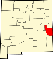
Quay County is a county in the state of New Mexico. As of the 2020 U.S. census, the population was 8,746. Its county seat is Tucumcari. The county was named for Pennsylvania senator Matthew Quay, who supported statehood for New Mexico. Its eastern border is the Texas state line, approximately 103.04 degrees west longitude.

<span class="mw-page-title-main">Chaves County, New Mexico</span> County in New Mexico, United States

Chaves County is a county in New Mexico, United States. As of the 2020 census, the population was 65,157. Its county seat is Roswell. Chaves County was named for Colonel Jose Francisco Chaves, a military leader there during the Civil War and later in Navajo campaigns. The county was created by the New Mexico Territorial Legislature on February 25, 1889, out of land from Lincoln County.

<span class="mw-page-title-main">Minidoka County, Idaho</span> County in Idaho, United States

Minidoka County is a county located in the U.S. state of Idaho. As of the 2020 census, the population was 21,613. The county seat and largest city is Rupert.

<span class="mw-page-title-main">Alondra Park, California</span> Census designated place in California, United States

Alondra Park, also known as El Camino Village, is a census designated place (CDP) in the South Bay region of Los Angeles County, California, United States. It is the unincorporated area north of Alondra Community Regional Park and El Camino College. It is east of Lawndale, south of Hawthorne, west of Gardena, and north of Torrance. Manhattan Beach Boulevard and Crenshaw Boulevard are the two major cross streets in the area. The population was 8,569 at the 2020 census, down from 8,592 at the 2010 census. There is an official Alondra Park Post Office of the U.S. Postal Service in nearby Gardena, California. Urbanized cement-lined Dominguez Creek bisects a portion of Alondra Park.

<span class="mw-page-title-main">West Menlo Park, California</span> Unincorporated community in California, United States

West Menlo Park is a census-designated place and an Unincorporated community in San Mateo County, California, located between the majority of City of Menlo Park, the Town of Atherton, the Sharon Heights neighborhood of Menlo Park and Stanford University. As of the 2020 census, the community had a population of 3,930.

<span class="mw-page-title-main">Hepburn, Iowa</span> City in Iowa, United States

Hepburn is a city in Page County, Iowa, United States. The population was 26 at the time of the 2020 census.

Roosevelt Township is a township in Beltrami County, Minnesota, United States. The population was 219 as of the 2000 census.

<span class="mw-page-title-main">Crooked Lake Township, Cass County, Minnesota</span> Township in Minnesota, United States

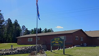
Crooked Lake Township is a township in Cass County, Minnesota, United States. The population was 498 as of the 2000 census. It is named after Roosevelt Lake, formerly known as Crooked Lake, a large lake located in this township. Crooked Lake is a translation from the Ojibwe Wewaagigamaag-zaaga'igan.

Roosevelt Township is a township in Crow Wing County, Minnesota, United States. The population was 534 at the 2000 census. Roosevelt Township was named for Theodore Roosevelt, 26th President of the United States.

<span class="mw-page-title-main">Froid, Montana</span> Town in Montana, United States

Froid is a town in Roosevelt County, Montana, United States. The population was 195 at the 2020 census. Froid was named for the French word for "cold".

<span class="mw-page-title-main">Evans, New York</span> Town in New York, United States

Evans is a town in Erie County, New York, United States. The population was 16,356 at the 2010 census. The town derives its name from David E. Evans, an agent of the Holland Land Company and nephew of land agent Joseph Ellicott.

<span class="mw-page-title-main">Medora, North Dakota</span> City in North Dakota, United States

Medora is a city in Billings County, North Dakota, United States. The only incorporated place in Billings County, it is also the county seat. Much of the surrounding area is part of either Little Missouri National Grassland or Theodore Roosevelt National Park. The population was 121 at the 2020 census. It is part of the Dickinson Micropolitan Statistical Area.

<span class="mw-page-title-main">Muhlenberg Township, Berks County, Pennsylvania</span> Township in Pennsylvania, United States

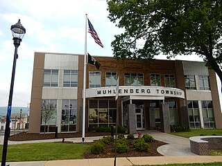
Muhlenberg Township is a township in Berks County, Pennsylvania, United States. The population was 21,915 at the 2020 census, making it the third-most populous township in Berks County after Spring Township and Exeter Township.

<span class="mw-page-title-main">Eleanor, West Virginia</span> Town in West Virginia, United States

Eleanor is a town in Putnam County, West Virginia, United States, along the Kanawha River. Its population was 1,548 at the 2020 census. It is part of the Huntington–Ashland metropolitan area. The town, named for Eleanor Roosevelt, was established as a New Deal project in the 1930s like other Franklin D. Roosevelt towns around the nation.

<span class="mw-page-title-main">North Mankato, Minnesota</span> City in Minnesota, United States

North Mankato is a city in Nicollet and Blue Earth counties in the State of Minnesota. The population was 14,275 at the 2020 census.

<span class="mw-page-title-main">Roosevelt, Minnesota</span> City in Minnesota, United States

Roosevelt is a city in Lake of the Woods and Roseau counties in the State of Minnesota. The population was 151 at the time of the 2010 census.

<span class="mw-page-title-main">De Baca County, New Mexico</span> County in New Mexico, United States

De Baca County is a county in the U.S. state of New Mexico. As of the 2020 census, the population was 1,698, making it New Mexico's second-least populous county. Its county seat is Fort Sumner. The county is named for Ezequiel Cabeza De Baca, the second elected Governor of New Mexico.

References

  1. "Roosevelt County, New Mexico". United States Census Bureau . Retrieved July 3, 2023.
  2. "Find a County". National Association of Counties. Retrieved June 7, 2011.
  3. "2010 Census Gazetteer Files". United States Census Bureau. August 22, 2012. Archived from the original on January 1, 2015. Retrieved January 2, 2015.
  4. "U.S. Decennial Census". United States Census Bureau. Retrieved January 2, 2015.
  5. "Historical Census Browser". University of Virginia Library. Retrieved January 2, 2015.
  6. "Population of Counties by Decennial Census: 1900 to 1990". United States Census Bureau. Retrieved January 2, 2015.
  7. "Census 2000 PHC-T-4. Ranking Tables for Counties: 1990 and 2000" (PDF). United States Census Bureau. Archived (PDF) from the original on March 27, 2010. Retrieved January 2, 2015.
  8. "State & County QuickFacts". United States Census Bureau. Archived from the original on June 6, 2011. Retrieved September 30, 2013.
  9. "U.S. Census website". United States Census Bureau . Retrieved January 31, 2008.
  10. 1 2 3 "DP-1 Profile of General Population and Housing Characteristics: 2010 Demographic Profile Data". United States Census Bureau. Archived from the original on February 13, 2020. Retrieved January 24, 2016.
  11. "Population, Housing Units, Area, and Density: 2010 - County". United States Census Bureau. Archived from the original on February 13, 2020. Retrieved January 24, 2016.
  12. "DP02 SELECTED SOCIAL CHARACTERISTICS IN THE UNITED STATES – 2006-2010 American Community Survey 5-Year Estimates". United States Census Bureau. Archived from the original on February 13, 2020. Retrieved January 24, 2016.
  13. "DP03 SELECTED ECONOMIC CHARACTERISTICS – 2006-2010 American Community Survey 5-Year Estimates". United States Census Bureau. Archived from the original on February 13, 2020. Retrieved January 24, 2016.
  14. "New Mexico: Officials Quit Over Marriage Ruling". The New York Times. November 20, 2013. Retrieved November 20, 2013.
  15. Leip, David. "Dave Leip's Atlas of U.S. Presidential Elections". uselectionatlas.org. Retrieved April 2, 2018.
  16. "2020 CENSUS - SCHOOL DISTRICT REFERENCE MAP: Roosevelt County, NM" (PDF). U.S. Census Bureau. Archived (PDF) from the original on July 13, 2022. Retrieved July 12, 2022. - Text list

34°01′N103°29′W / 34.02°N 103.48°W / 34.02; -103.48