Loxley, Alabama

Last updated

Loxley, Alabama
Burris Farm Market.jpg
Burris Farm Market located in Loxley
Motto: 
"Biggest Little Town in Baldwin"
Baldwin County Alabama Incorporated and Unincorporated areas Loxley Highlighted 0144608.svg
Location of Loxley in Baldwin County, Alabama.
Coordinates: 30°37′25″N87°45′17″W / 30.62361°N 87.75472°W / 30.62361; -87.75472
Country United States
State Alabama
County Baldwin
Government
  TypeCity Council and Mayor
  MayorRichard Teal
Area
[1]
  Total32.25 sq mi (83.54 km2)
  Land31.87 sq mi (82.55 km2)
  Water0.38 sq mi (0.99 km2)
Elevation
171 ft (52 m)
Population
 (2020)
  Total3,710
  Density116.40/sq mi (44.94/km2)
Time zone UTC-6 (Central (CST))
  Summer (DST) UTC-5 (CDT)
ZIP code
36551
Area code 251
FIPS code 01-44608
GNIS feature ID0155142
Website www.cityofloxley.com

Loxley is a city in Baldwin County, Alabama, United States. As of the 2010 census, the population of the town was 1,632. [2] It is part of the Daphne-Fairhope-Foley metropolitan area. Loxley is becoming a popular location for the expansion of the suburbs from Daphne and Spanish Fort, Alabama, because it is served by an Interstate 10 exit and is almost directly between the cities of Mobile, Alabama, and Pensacola, Florida.

Contents

History

19th century

In 1870, a man from Chicago by the name of John Loxley established a lumber camp in the area previously known as Bennet. The lumber camp included a commissary and saw mill. The men that traveled with Loxley settled in what later became the town of Loxley. John Loxley returned to Chicago when the lumber was exhausted. [3]

20th century

The train depot opened on May 5, 1906, on the Fort Morgan Line. Before that, there were only wagon roads to Bay Minette. Also in 1906, the Loxley post office was opened by Octavia Sauer. She served as the postmistress and depot agent. By 1920, the businesses in Loxley consisted of an egg store, grocery store, two general merchandise stores, train depot, drug store, telegraph office, land office, repair garage, post office, bank, hotel, butcher shop, orange packing shed, cement block plant, a blacksmith, a feed and lumber store. A grammar school was built in 1925. [3]

The Town of Loxley incorporated in March 1957. [3]

Geography

Loxley is located in south-central Baldwin County at 30°37'24.600" North, 87°45'17.035" West (30.623500, -87.754732). [4] U.S. Route 90 (Hickory Street) passes through the center of the town, leading eastbound 5 miles (8 km) to Robertsdale, Alabama, and 39 miles (63 km) to Pensacola, Florida, and westbound 11 miles (18 km) to Spanish Fort and 20 miles (32 km) to Mobile. Interstate 10 passes through the northern end of town, with access via Exit 44 (Alabama State Route 59).

According to the U.S. Census Bureau, the town has a total area of 32.2 square miles (83.4 km2), of which 31.9 square miles (82.5 km2) is land and 0.39 square miles (1.0 km2), or 1.15%, is water. [2]

Demographics

Historical population
CensusPop.Note
1960 831
1970 8593.4%
1980 804−6.4%
1990 1,16144.4%
2000 1,34816.1%
2010 1,63221.1%
2020 3,710127.3%
U.S. Decennial Census [5]
2013 Estimate [6]

2020 census

Loxley racial composition [7]
RaceNum.Perc.
White (non-Hispanic)2,75174.15%
Black or African American (non-Hispanic)38710.43%
Native American 140.38%
Asian 681.83%
Pacific Islander 30.08%
Other/Mixed 2436.55%
Hispanic or Latino 2446.58%

As of the 2020 United States census, there were 3,710 people, 868 households, and 608 families residing in the town.

2010 census

As of the census [8] of 2010, there were 1,632 people, 643 households, and 453 families residing in the town. The population density was 51 people per square mile (20 people/km2). There were 737 housing units at an average density of 22.9 units per square mile (8.8 units/km2). The racial makeup of the town was 84.4% White, 9.4% Black or African American, 0.7% Native American, 0.6% Asian, 3.4% from other races, and 1.5% from two or more races. 5.1% of the population were Hispanic or Latino of any race.

There were 643 households, out of which 29.5% had children under the age of 18 living with them, 49.9% were married couples living together, 14.6% had a female householder with no husband present, and 29.5% were non-families. 25.8% of all households were made up of individuals, and 10.6% had someone living alone who was 65 years of age or older. The average household size was 2.53 and the average family size was 3.00.

In the town, the population was spread out, with 23.9% under the age of 18, 10.4% from 18 to 24, 29.4% from 25 to 44, 26.0% from 45 to 64, and 12.3% who were 65 years of age or older. The median age was 36.2 years. For every 100 females, there were 99.0 males. For every 100 females age 18 and over, there were 102.3 males.

The median income for a household in the town was $32,803, and the median income for a family was $36,042. Males had a median income of $36,563 versus $27,566 for females. The per capita income for the town was $19,796. About 16.7% of families and 20.8% of the population were below the poverty line, including 34.6% of those under age 18 and 13.1% of those age 65 or over.

Government

Loxley is an incorporated city located in Baldwin County, Alabama. It is governed by a mayor and city council, both of which are elected by popular vote every four years. On May 20, 2022, Loxley officially became a city. [9]

2022 Tornado event

On March 30/31, a destructive tornado passed 10 miles northeast of the city, which was spawned by the large tornado outbreak of March 29–31, 2022.

Loxley's original elementary school Loxley elementary 1927 122915-tdw.jpg
Loxley's original elementary school

Education

Loxley is a part of the Baldwin County Public Schools system.

Schools

Public

Events

Loxley hosts the Baldwin County Strawberry Festival every spring.

See also

Related Research Articles

<span class="mw-page-title-main">Baldwin County, Alabama</span> County in Alabama, United States

Baldwin County is a county located in the southwestern part of the U.S. state of Alabama, on the Gulf coast. It is one of only two counties in Alabama that border the Gulf of Mexico, along with Mobile County. As of the 2020 census, the population was 231,767, making it the fourth-most populous county in Alabama. The county seat is Bay Minette. The county is named after the founder of the University of Georgia, Senator Abraham Baldwin.

<span class="mw-page-title-main">Bay Minette, Alabama</span> City in and county seat of Baldwin County, Alabama

Bay Minette is a city in and the county seat of Baldwin County, Alabama, United States. As of the 2010 census, the population of the city was 8,044.

<span class="mw-page-title-main">Elberta, Alabama</span> Town in Alabama, United States

Elberta is a town in Baldwin County, Alabama, United States. At the 2010 census the population was 1,498, up from 552 at the 2000 census. It is part of the Daphne-Fairhope-Foley metropolitan area.

<span class="mw-page-title-main">Robertsdale, Alabama</span> City in Alabama, United States

Robertsdale is a city in Baldwin County, Alabama, United States, which includes the community of Rosinton. At the 2020 census, the population was 6,708. It is part of the Daphne-Fairhope-Foley metropolitan area.

<span class="mw-page-title-main">Silverhill, Alabama</span> Town in Alabama, United States

Silverhill is a town in Baldwin County, Alabama, United States. As of the 2010 census, the population was 706. It is part of the Daphne-Fairhope-Foley metropolitan area.

<span class="mw-page-title-main">Summerdale, Alabama</span> Town in Alabama, United States

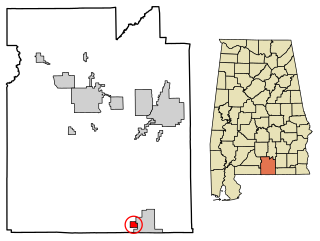
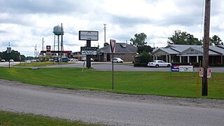
Summerdale is a rural town in south-central Baldwin County, Alabama, United States. It is the site of the Naval Outlying Landing Field Summerdale. At the 2020 census, the population was 1,468. It is part of the Daphne–Fairhope–Foley Metropolitan Statistical Area.

<span class="mw-page-title-main">Littleville, Alabama</span> Town in Alabama, United States

Littleville is a town located on the southern border of Colbert County, Alabama, United States, and extends into Franklin County. It is part of the Florence - Muscle Shoals Metropolitan Statistical Area known as "The Shoals". As of the 2010 census, the population of the town was 1,011.

<span class="mw-page-title-main">Lockhart, Alabama</span> Town in Alabama, United States

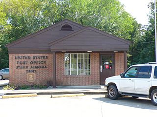
Lockhart is a town in Covington County, Alabama, United States. At the 2020 census, the population was 445.

<span class="mw-page-title-main">Brewton, Alabama</span> City in and county seat of Escambia County, Alabama

Brewton is a city in and the county seat of Escambia County, Alabama, United States. As of the 2020 census, the population was 5,276. Brewton is located in south central Alabama, just north of the Florida Panhandle.

<span class="mw-page-title-main">Guin, Alabama</span> City in Alabama, United States

Guin is a city in Marion County, Alabama, United States. It incorporated in December 1889. At the 2020 census, the population was 2,195.

<span class="mw-page-title-main">Excel, Alabama</span> Town in Alabama, United States

Excel is a town in Monroe County, Alabama, United States. At the 2020 census, the population was 557. The current mayor is Jenny Countryman.

<span class="mw-page-title-main">Steele, Alabama</span> Town in Alabama, United States

Steele is a town in northeastern St. Clair County, Alabama, United States. It was incorporated in 1952. At the 2010 census the population was 1,043, down from 1,093. The town is a part of the Birmingham–Hoover–Cullman Combined Statistical Area. It was initially known as Steel's Station or Steele's Depot in the late 19th century.

<span class="mw-page-title-main">Lake View, Alabama</span> City in Alabama, United States

Lake View is a city in Alabama, United States, with the majority in Tuscaloosa County and with a small portion in Jefferson County. At the 2010 census the population was 1,943, up from 1,357 in 2000. It is part of the Tuscaloosa Metropolitan Statistical Area and the Birmingham metropolitan area. It is located approximately halfway between Tuscaloosa and Birmingham via Interstates 20 and 59.

<span class="mw-page-title-main">Maxwell, Iowa</span> City in Iowa, United States

Maxwell is a city in Story County, Iowa, United States. The population was 859 at the time of the 2020 census. It is part of the Ames, Iowa Metropolitan Statistical Area, which is a part of the larger Ames-Boone, Iowa Combined Statistical Area.

<span class="mw-page-title-main">Roscommon Township, Michigan</span> Civil township in Michigan, United States

Roscommon Township is a civil township of Roscommon County in the U.S. state of Michigan. The population was 4,397 at the 2020 census.

<span class="mw-page-title-main">Bigelow, Minnesota</span> City in Minnesota, United States

Bigelow is a city in Nobles County, Minnesota, United States. The population was 235 at the 2010 census.

<span class="mw-page-title-main">Kinbrae, Minnesota</span> City in Minnesota, United States

Kinbrae is a city in Nobles County, Minnesota, United States. The population was 10 at the 2020 census, making the city the least populous incorporated place in Minnesota.

<span class="mw-page-title-main">Loretto, Tennessee</span> City in Tennessee, United States

Loretto is a city in Lawrence County, Tennessee, United States. The population was 1,714 at the 2010 census, and 1,739 at the 2020 census.

<span class="mw-page-title-main">Woodstock, Alabama</span> Town in Alabama, United States

Woodstock is a town in Bibb and Tuscaloosa counties in the U.S. state of Alabama. Formerly known as North Bibb, by referendum in August 2000, the town adopted the name of a long-established local unincorporated community and, as of October 1, 2000, is now known officially as "Woodstock". As of the 2010 census, the population of the town was 1,428.

Hampden is a census-designated place (CDP) consisting of the eastern portion of the town of Hampden in Penobscot County, Maine, United States. The population of the CDP was 4,343 at the 2010 census.

References

  1. "2020 U.S. Gazetteer Files". United States Census Bureau. Retrieved October 29, 2021.
  2. 1 2 "Geographic Identifiers: 2010 Demographic Profile Data (G001): Loxley town, Alabama". U.S. Census Bureau, American Factfinder. Archived from the original on February 12, 2020. Retrieved September 13, 2013.
  3. 1 2 3 "Baldwin County Express". baldwinexpress.org. Archived from the original on September 14, 2009.
  4. "US Gazetteer files: 2010, 2000, and 1990". United States Census Bureau. February 12, 2011. Retrieved April 23, 2011.
  5. "U.S. Decennial Census". Census.gov. Retrieved June 6, 2013.
  6. "Annual Estimates of the Resident Population: April 1, 2010 to July 1, 2013" . Retrieved June 3, 2014.
  7. "Explore Census Data". data.census.gov. Retrieved December 17, 2021.
  8. "U.S. Census website". United States Census Bureau . Retrieved July 7, 2015.
  9. "Fox 10 News". fox10tv.com. Archived from the original on September 14, 2009.

30°37′25″N87°45′17″W / 30.6235°N 87.754732°W / 30.6235; -87.754732