Robertsdale, Alabama

Last updated

Robertsdale, Alabama
Flag of Robertsdale, Alabama.svg
Robertsdale-Seal.png
Nickname: 
The Hub of Baldwin County
Baldwin County Alabama Incorporated and Unincorporated areas Robertsdale Highlighted 0165208.svg
Location of Robertsdale in Baldwin County, Alabama.
Coordinates: 30°33′16″N87°42′20″W / 30.55444°N 87.70556°W / 30.55444; -87.70556
Country United States
State Alabama
County Baldwin
Incorporated 1921
Government
   Mayor Charles H. Murphy
Area
[1]
  Total6.93 sq mi (17.94 km2)
  Land6.92 sq mi (17.91 km2)
  Water0.01 sq mi (0.03 km2)
Elevation
148 ft (45 m)
Population
 (2020)
  Total6,708
  Density970.07/sq mi (374.56/km2)
Time zone UTC-6 (CST)
  Summer (DST) UTC-5 (CDT)
ZIP codes
36567, 36574
Area code 251
FIPS code 01-65208
GNIS feature ID0125703
Website www.robertsdale.org

Robertsdale is a city in Baldwin County, Alabama, United States, which includes the community of Rosinton. At the 2020 census, the population was 6,708. It is part of the Daphne-Fairhope-Foley metropolitan area.

Contents

Geography

Robertsdale is located in southern Baldwin County at 30°33'16.034" North, 87°42'20.038" West (30.554454, -87.705566). [2] U.S. Route 90 (Old Spanish Trail) passes through the city, leading west 24 miles (39 km) to Mobile and east 35 miles (56 km) to Pensacola, Florida.

According to the U.S. Census Bureau, the city has a total area of 5.5 square miles (14.2 km2), of which 0.012 square miles (0.03 km2), or 0.24%, is water. [3]

Demographics

Historical population
CensusPop.Note
1930 678
1940 77914.9%
1950 1,12844.8%
1960 1,47430.7%
1970 2,07841.0%
1980 2,30611.0%
1990 2,4014.1%
2000 3,78257.5%
2010 5,27639.5%
2020 6,70827.1%
U.S. Decennial Census [4]
2013 Estimate [5]
Robertsdale welcome sign Rdale welcomesign2.jpg
Robertsdale welcome sign

2020 Census data

Robertsdale racial composition [6]
RaceNum.Perc.
White (non-Hispanic)5,27078.56%
Black or African American (non-Hispanic)5127.63%
Native American 360.54%
Asian 610.91%
Pacific Islander 30.04%
Other/Mixed 3234.82%
Hispanic or Latino 5037.5%

As of the 2020 United States census, there were 6,708 people, 2,349 households, and 1,532 families residing in the city.

2010 Census data

As of the census [7] of 2010, there were 5,276 people, 1,951 households, and 1,392 families residing in the city. The population density was 968 inhabitants per square mile (374/km2). There were 1,573 housing units at an average density of 357.3 per square mile (138.0/km2). The racial makeup of the city was 85.3% White, 5.4% Black or African American, 0.8% Native American, 0.5% Asian, 6.1% from other races, and 1.9% from two or more races. 9.2% of the population were Hispanic or Latino of any race.

There were 1,951 households, out of which 36.1% had children under the age of 18 living with them, 51.4% were married couples living together, 14.6% had a female householder with no husband present, and 28.7% were non-families. 23.7% of all households were made up of individuals, and 10.2% had someone living alone who was 65 years of age or older. The average household size was 2.64 and the average family size was 3.10.

In the city, the population was 27.3% under the age of 18, 9.0% from 18 to 24, 28.7% from 25 to 44, 20.9% from 45 to 64, and 14.2% who were 65 years of age or older. The median age was 33.8 years. For every 100 females, there were 89.7 males. For every 100 females age 18 and over, there were 93.9 males. The median income for a household in the city was $41,750, and the median income for a family was $47,253. Males had a median income of $41,822 versus $26,239 for females. The per capita income for the city was $20,696. About 8.1% of families and 10.1% of the population were below the poverty line, including 12.2% of those under age 18 and 9.7% of those age 65 or over.

Education

Robertsdale is a part of the Baldwin County Public Schools system. Three elementary schools, a middle school, and a high school serve Robertsdale. A vocational school is also located in Robertsdale.[ citation needed ]

Schools

Public

Private

  • Central Christian School (K-12)
  • St. Patrick Catholic School (K3-8)

Transportation

The Baldwin Regional Area Transit System (BRATS) provides demand-responsive transit services within Robertsdale and Baldwin County.

Events

Notable people

See also

Related Research Articles

<span class="mw-page-title-main">Baldwin County, Alabama</span> County in Alabama, United States

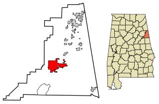
Baldwin County is a county located in the southwestern part of the U.S. state of Alabama, on the Gulf coast. It is one of only two counties in Alabama that border the Gulf of Mexico, along with Mobile County. As of the 2020 census, the population was 231,767, making it the fourth-most populous county in Alabama. The county seat is Bay Minette. The county is named after the founder of the University of Georgia, Senator Abraham Baldwin.

<span class="mw-page-title-main">Franklin County, Alabama</span> County in Alabama, United States

Franklin County is a county located in the U.S. state of Alabama. As of the 2020 census, the population was 32,113. Its county seat is Russellville. Its name is in honor of Benjamin Franklin, famous statesman, scientist, and printer. It is a dry county, although the city of Russellville is wet.

<span class="mw-page-title-main">Bay Minette, Alabama</span> City in and county seat of Baldwin County, Alabama

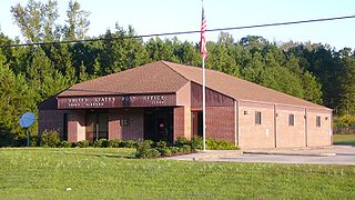
Bay Minette is a city in and the county seat of Baldwin County, Alabama, United States. As of the 2010 census, the population of the city was 8,044.

<span class="mw-page-title-main">Foley, Alabama</span> City in Alabama, United States

Foley is a city in Baldwin County, Alabama, United States. The 2010 census lists the population of the city as 14,618. Foley is a principal city of the Daphne-Fairhope-Foley metropolitan area, which includes all of Baldwin County.

<span class="mw-page-title-main">Gulf Shores, Alabama</span> City in Alabama, United States

Gulf Shores is a resort city in Baldwin County, Alabama, United States. As of the 2020 Census, the population was 15,014.

<span class="mw-page-title-main">Loxley, Alabama</span> City in Alabama, United States

Loxley is a city in Baldwin County, Alabama, United States. As of the 2010 census, the population of the town was 1,632. It is part of the Daphne-Fairhope-Foley metropolitan area. Loxley is becoming a popular location for the expansion of the suburbs from Daphne and Spanish Fort, Alabama, because it is served by an Interstate 10 exit and is almost directly between the cities of Mobile, Alabama, and Pensacola, Florida.

<span class="mw-page-title-main">Silverhill, Alabama</span> Town in Alabama, United States

Silverhill is a town in Baldwin County, Alabama, United States. As of the 2010 census, the population was 706. It is part of the Daphne-Fairhope-Foley metropolitan area.

<span class="mw-page-title-main">Spanish Fort, Alabama</span> City in Alabama, United States

Spanish Fort is a city in Baldwin County, Alabama, United States, located on the eastern shore of Mobile Bay. The 2020 census lists the population of the city as 10,049. It is a suburb of Mobile and is part of the Daphne-Fairhope-Foley metropolitan area.

<span class="mw-page-title-main">Summerdale, Alabama</span> Town in Alabama, United States

Summerdale is a rural town in south-central Baldwin County, Alabama, United States. It is the site of the Naval Outlying Landing Field Summerdale. At the 2020 census, the population was 1,468. It is part of the Daphne–Fairhope–Foley Metropolitan Statistical Area.

<span class="mw-page-title-main">Vance, Alabama</span> Town in Alabama, United States

Vance is a town in Tuscaloosa and Bibb counties in the U.S. state of Alabama. As of the 2010 census it had a population of 1,529. It is most famous for the Mercedes-Benz U.S. International plant, currently the only one in North America. The current mayor of Vance is Brenda Morrison.

<span class="mw-page-title-main">Heflin, Alabama</span> City in Alabama, United States

Heflin is a city and the county seat of Cleburne County, Alabama, United States. At the 2020 census, the population was 3,431. It is located approximately halfway between Birmingham and Atlanta along Interstate 20.

<span class="mw-page-title-main">Red Bay, Alabama</span> City in Alabama, United States

Red Bay is a city in Franklin County, Alabama, United States. It was founded in 1907; its western boundary line is integral with the state line between Mississippi and Alabama. The population was 3,232 at the 2020 census. The town's name comes from the area's red clay soil and the many redbay trees in this area of north Alabama.

<span class="mw-page-title-main">Tillmans Corner, Alabama</span> Unincorporated community in Alabama, United States

Tillmans Corner, or Tillman’s Corner, is an unincorporated community and census-designated place (CDP) in Mobile County, Alabama, United States. At the 2020 census, the population was 17,731. It is part of the Mobile metropolitan area, and is the largest census-designated place in Alabama.

<span class="mw-page-title-main">Jasper, Alabama</span> City in Alabama, United States

Jasper is a city in and the county seat of Walker County, Alabama, United States. Its population was 14,352 as of the 2010 census. Named in honor of Sergeant William Jasper, an American Revolutionary War hero, Jasper was settled around 1815 and incorporated on August 18, 1886.

<span class="mw-page-title-main">Double Springs, Alabama</span> City in and county seat of Winston County, Alabama

Double Springs is a town in Winston County, Alabama, United States. The city is the county seat of Winston County. The county seat was initially located at Houston, but by referendum in 1883, Double Springs prevailed and it was removed to there. It was incorporated on May 17, 1943. At the 2010 census the population was 1,083, up from 1,003 in 2000.

<span class="mw-page-title-main">Oakland, Florida</span> Town in the state of Florida, United States

Oakland is a town in Orange County, Florida, United States. The population was 3,516 at the 2020 Census, representing a growth of 38.5% over the population of 2,538 recorded during the 2010 census. It is part of the Orlando–Kissimmee Metropolitan Statistical Area.

<span class="mw-page-title-main">Baldwin City, Kansas</span> City in Kansas, United States

Baldwin City is a city in Douglas County, Kansas, United States, about 12 miles (19 km) south of Lawrence. As of the 2020 census, the population of the city was 4,826. The city is home to Baker University, the state's oldest four-year university.

<span class="mw-page-title-main">Dixon, Kentucky</span> City in Kentucky, United States

Dixon is a home rule-class city in and the county seat of Webster County, Kentucky, United States. The population was 933 at the 2020 census. Dixon is located at the junction of US 41A and KY 132. It was established with a courthouse and post office in 1860 when the county was formed.

<span class="mw-page-title-main">Baldwin Park, Missouri</span> Village in Missouri, United States

Baldwin Park is a village in Cass County, Missouri, United States. The population was 92 at the 2010 census. It is part of the Kansas City metropolitan area.

<span class="mw-page-title-main">Ashland, Chemung County, New York</span> Town in New York, United States

Ashland is a town in Chemung County, New York, United States. The population was 1,515 at the 2020 census. The town is named after the home of Henry Clay.

References

  1. "2020 U.S. Gazetteer Files". United States Census Bureau. Retrieved October 29, 2021.
  2. "US Gazetteer files: 2010, 2000, and 1990". United States Census Bureau. February 12, 2011. Retrieved April 23, 2011.
  3. "Geographic Identifiers: 2010 Demographic Profile Data (G001): Robertsdale city, Alabama". U.S. Census Bureau, American Factfinder. Archived from the original on February 12, 2020. Retrieved September 9, 2013.
  4. "U.S. Decennial Census". Census.gov. Retrieved June 6, 2013.
  5. "Annual Estimates of the Resident Population: April 1, 2010 to July 1, 2013" . Retrieved June 3, 2014.
  6. "Explore Census Data". data.census.gov. Retrieved December 17, 2021.
  7. "U.S. Census website". United States Census Bureau . Retrieved July 7, 2015.
  8. "Baldwin County Fair Information". Baldwin County Cattle & Fair Association. Archived from the original on November 19, 2008. Retrieved July 17, 2023.
  9. "Christmas Parade & Christmas in the Park | City of Robertsdale, Alabama". www.robertsdale.org. Archived from the original on February 5, 2012.

30°33′16″N87°42′20″W / 30.554454°N 87.705566°W / 30.554454; -87.705566