MBTA subway

Last updated

MBTA subway
Red Line train entering Alewife station (2), November 2019.jpg
Red Line train entering Alewife station in November 2019
Overview
Locale Greater Boston, Massachusetts
Number of lines3 heavy rail (Red, Orange, Blue)
2 light rail (Green, Ashmont–Mattapan)
1 bus rapid transit (Silver)
Number of stations153 (list of stations)
Annual ridership85,397,200 (heavy rail, 2023)
34,581,000 (light rail, 2023) [1]
Website mbta.com
Operation
Began operationSeptember 1, 1897 (Tremont Street subway)
Operator(s) Massachusetts Bay Transportation Authority (MBTA)
Train length6 cars (rapid transit)
1-3 cars (light rail)
Technical
System length68.7 mi (110.6 km) – rail

The Massachusetts Bay Transportation Authority (MBTA) operates rapid transit (heavy rail), light rail, and bus rapid transit services in the Boston metropolitan area, collectively referred to as the rapid transit, subway, or the T system. [2]

Contents

The color-branded lines consist of three heavy rail lines (Red, Orange, and Blue), one branched light rail system (Green), and a short light rail line (the Ashmont–Mattapan High-Speed Line, colored as part of the Red Line). All except the Ashmont–Mattapan line operate in tunnels in the downtown area, but no route operates entirely underground, and only 31 out of the system's 153 stations are located underground. The five branches of the Silver Line bus network are also shown as part of the rapid transit system. Three branches operate underground and charge rapid transit fares; two branches operate entirely on the surface and charge lower bus fares.

In 2023, the heavy rail lines had 85,397,200 rides, [1] or about 267,100 per weekday [3] in the fourth quarter of 2023, and comprised the fourth-busiest heavy rail system in the United States. In the same period, the light rail lines had 34,581,000 rides, or about 80,300 per weekday, and comprised the third-busiest light rail system in the United States.

The section of the Tremont Street subway between Park Street and Boylston Street stations, now on the Green Line, opened in 1897, making it the oldest transit subway in the United States still in use. (Only the short-lived Beach Pneumatic Transit demonstration line in New York City was built before.)

History

Streetcar number 1752, driven by the veteran motorman Jimmy Reed, is shown here after it became the first revenue car in the Boston subway system on September 1, 1897. This also marked the beginning of subway traffic in the United States. First car into Tremont Street Subway, pictured at Allston carhouse.png
Streetcar number 1752, driven by the veteran motorman Jimmy Reed, is shown here after it became the first revenue car in the Boston subway system on September 1, 1897. This also marked the beginning of subway traffic in the United States.

Opened in September 1897, the four-track-wide segment of the Green Line tunnel between Park Street and Boylston stations was the first subway in the United States, and has been designated a National Historic Landmark. The downtown portions of what are now the Green, Orange, Blue, and Red line tunnels were all in service by 1912. Additions to the rapid transit network occurred in most decades of the 1900s, and continued in the 2000s with the addition of Silver Line bus rapid transit and Green Line Extension.[ citation needed ] (See MBTA History and MBTA Future plans sections.)

Streetcar congestion in downtown Boston led to the creation of underground subways and elevated rail, the former in 1897 and the latter in 1901. The Tremont Street subway was the first rapid transit tunnel in the United States and had a 24/7 service. [4] The grade-separated railways added transportation capacity while avoiding delays caused by intersections with cross streets. [5] The first elevated railway and the first rapid transit line in Boston were built three years before the first underground line of the New York City Subway, but 34 years after the first London Underground lines, and long after the first elevated railway in New York City. [6]

Various extensions and branches were added to the subway lines at both ends, bypassing more surface tracks. As grade-separated lines were extended, street-running lines were cut back for faster downtown service. The last elevated heavy rail or "El" inter-station segments in Boston – with the exception of the Red Line's still-active elevated tracks, connecting Charles/MGH station over Charles Circle to the Longfellow Bridge and the Cambridge Tunnel's northern portal – were at the extremities of the Orange Line: its northern end was relocated in 1975 from Everett to Malden, MA, and its southern end was relocated into the Southwest Corridor in 1987. However, the Green Line's Causeway Street Elevated remained in service until 2004, when it was relocated into a tunnel with an incline to reconnect to the Lechmere Viaduct.

The final section of elevated, between the Lechmere Viaduct and Lechmere station, was closed in 2020 for construction of the Green Line Extension. The extension opened in two phases in 2022 with new branches from Lechmere to Union Square and Medford/​Tufts – the first rail expansion since 1987.

System

Network map

MBTA subway

Lines

The rapid transit lines consist of 3 heavy rail (Metro) lines, 2 light rail lines, and a bus rapid transit line. The heavy rail Red Line has two southern branches, while the light rail Green Line has four services (B, C, D, and E) that use four western and two northern branches. The Silver Line has five bus rapid transit routes; two run on Washington Street with different downtown terminals, while three run underground in the Seaport with surface branches.

LineRouteInaugurationRoute lengthNumber of stations
Green Line 189726.7 mi (43.0 km)70
Orange Line Oak GroveForest Hills 190111 mi (18 km)20
Blue Line WonderlandBowdoin 19046 mi (9.7 km)12
Red Line
191222.5 mi (36.2 km)22
Ashmont–Mattapan High-Speed Line Ashmont ↔ Mattapan 19292.5 mi (4.0 km)8
Silver Line
200234
Heavy rail subtotal39.5 mi (63.6 km)52 [note 1]
Light rail subtotal29.2 mi (47.0 km)78 [note 2]
Total68.1 mi (109.6 km)153 [note 3]

Coverage

To-scale map of the Boston subway system from 2022 MBTA Subway Geographic Map (2022).svg
To-scale map of the Boston subway system from 2022

All four subway lines cross downtown, forming a quadrilateral configuration, and the Orange and Green Lines (which run approximately parallel in that district) also connect directly at two stations just north of downtown. The Red Line and Blue Line are the only pair of subway lines which do not have a direct transfer connection to each other. Because the various subway lines do not consistently run in any given compass direction, it is customary to refer to line directions as "inbound" or "outbound". Inbound trains travel towards the four downtown transfer stationsPark Street, State Street, Government Center and Downtown Crossing–and outbound trains travel away from these hub stations. [7]

Colors

Originally, transit lines in the region only used geographic names; though numbering was added to public maps in 1936. The three heavy rail lines were assigned numbers 1, 2, and 3; what is now the Green Line was assigned different numbers for each branch. However, riders generally continued to use the geographic names. [8] Colors were assigned on August 26, 1965, as part of a wider modernization under design standards developed by Cambridge Seven Associates, and have served as the primary identifier for the lines since then. [9] The numbers for the heavy rail lines and the Mattapan Line were retained in public information until 1966. [8] In 1967, the then-current five branches of the Green Line were lettered A through E. [8]

Cambridge Seven originally intended to use red, yellow, green, and blue for the four lines. However, yellow proved unsuitable, since some patrons would have difficulty reading yellow text on a white background; orange was substituted, and yellow eventually was used for the MBTA bus service's visibility markings and signage. [10] When sketching design concepts, Peter Chermayeff labeled the subway-surface light rail routes as the Green Line because they run adjacent to parts of the Emerald Necklace park system. The East Boston Tunnel became the Blue Line because it runs under Boston Harbor, and the Cambridge-Dorchester Tunnel became the Red Line because its northernmost terminus was then at Harvard University, whose school color is crimson. According to Chermayeff, the Main Line El "ended up being orange for no particular reason beyond color balance." [11] The MBTA and transit historians later claimed that orange came from Orange Street, an early name for the street that ran southwards down the Boston Neck to connect the Shawmut Peninsula to the mainland, for what is now part of Washington Street. [12] [13] [10]

Stations

The MBTA rapid transit system consists of 153 stations, with the 5 most recent stations opening on December 12, 2022 as part of the Medford/Tufts branch of the Green Line Extension project in Somerville.

Rolling stock

The MBTA is in the process of replacing its entire fleet of Red Line and Orange Line cars, which are over 40 years old, by 2023. The Blue Line cars were replaced in 2008. The Green Line has a variety of vehicles, some dating back to 1986, with the latest batch delivered in 2019.

All four transit lines use standard-gauge railway tracks (4 ft 8+12 in / 1,435 mm), but are otherwise incompatible, with varying loading gauges, car lengths, platform heights, and power collection systems as detailed in the chart below:

MBTA subway car dimensions [14]
LineCar lengthCar widthPlatform heightPower
Red 69 ft 6 in (21.2 m)10 ft (3.05 m)49 in (1.24 m)Third rail
Orange 65 ft (19.8 m)9 ft 3 in (2.82 m)45 in (1.14 m)Third rail
Blue 48 ft (14.6 m)9 ft 3 in (2.82 m)41+12 in (1.05 m)Third rail, overhead line
Green 72–74 ft (21.9–22.6 m)8 ft 8 in (2.64 m)8 in (0.20 m)Overhead line

There are no direct track connections between lines, except between the Red Line and Ashmont–Mattapan High Speed Line, but all except the Blue Line have little-used connections to the national rail network, which have been used for deliveries of railcars and supplies. [15]

Fares

MBTA subway fares are $2.40 regardless of fare medium (CharlieCard, paper ticket, or cash), with two transfers on MBTA bus local routes allowed. Daily, weekly, and monthly passes are also available, and MBTA Commuter Rail passes for these time periods are valid for subway fares. [16] Discounted fares are available for groups including adults over 65, people with disabilities, certain schoolchildren, and young adults with low incomes. Children under 11, legally blind people, and certain government workers are allowed to ride free of charge. [17]

All Blue, Orange, and Red Line stations are fare controlled with faregates, as are underground Green and Silver Line stations (plus the aboveground Science Park and Riverside stations). Green Line Extension stations require proof of payment verification at a fare machine. All other aboveground Green and Silver Line stations require payment when boarding the vehicle. [16]

See also

Related Research Articles

<span class="mw-page-title-main">Massachusetts Bay Transportation Authority</span> Public transport agency in the U.S.

The Massachusetts Bay Transportation Authority is the public agency responsible for operating most public transportation services in Greater Boston, Massachusetts. The MBTA transit network includes the MBTA subway with three metro lines, two light rail lines, and a five-line bus rapid transit system ; MBTA bus local and express service; the twelve-line MBTA Commuter Rail system, and several ferry routes. In 2023, the system had a ridership of 239,981,700, or about 755,500 per weekday as of the fourth quarter of 2023, of which the rapid transit lines averaged 267,100 and the light rail lines 80,300, making it the fourth-busiest rapid transit system and the third-busiest light rail system in the United States. As of the fourth quarter of 2023, average weekday ridership of the commuter rail system was 97,100, making it the fifth-busiest commuter rail system in the U.S.

<span class="mw-page-title-main">Transportation in Boston</span> Overview of transportation in Boston, Massachusetts, United States

Transportation in Boston includes roadway, subway, regional rail, air, and sea options for passenger and freight transit in Boston, Massachusetts. The Massachusetts Port Authority (Massport) operates the Port of Boston, which includes a container shipping facility in South Boston, and Logan International Airport, in East Boston. The Massachusetts Bay Transportation Authority (MBTA) operates bus, subway, short-distance rail, and water ferry passenger services throughout the city and region. Amtrak operates passenger rail service to and from major Northeastern cities, and a major bus terminal at South Station is served by varied intercity bus companies. The city is bisected by major highways I-90 and I-93, the intersection of which has undergone a major renovation, nicknamed the Big Dig.

<span class="mw-page-title-main">Red Line (MBTA)</span> Rapid transit line in Massachusetts, US

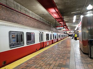
The Red Line is a rapid transit line operated by the Massachusetts Bay Transportation Authority (MBTA) as part of the MBTA subway system. The line runs south and east underground from Alewife station in North Cambridge through Somerville and Cambridge, surfacing to cross the Longfellow Bridge then returning to tunnels under Downtown Boston. It continues underground through South Boston, splitting into two branches on the surface at JFK/UMass station. The Ashmont branch runs southwest through Dorchester to Ashmont station, where the connecting light rail Ashmont–Mattapan High Speed Line continues to Mattapan station. The Braintree branch runs southeast through Quincy and Braintree to Braintree station.

<span class="mw-page-title-main">Green Line (MBTA)</span> Light rail system

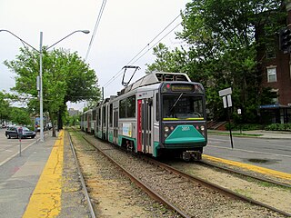
The Green Line is a semi-metro system run by the Massachusetts Bay Transportation Authority (MBTA) in the Boston, Massachusetts, metropolitan area. It is the oldest MBTA subway line, and with tunnel sections dating from 1897, the oldest subway in North America. It runs underground through downtown Boston, and on the surface into inner suburbs via six branches on radial boulevards and grade-separated alignments. With an average daily weekday ridership of 137,700 in 2019, it is the third most heavily used light rail system in the country. The line was assigned the green color in 1967 during a systemwide rebranding because several branches pass through sections of the Emerald Necklace of Boston.

<span class="mw-page-title-main">Silver Line (MBTA)</span> Bus rapid transit system in Massachusetts, US

The Silver Line is a system of bus routes in Boston and Chelsea, Massachusetts, operated by the Massachusetts Bay Transportation Authority (MBTA). It is operated as part of the MBTA bus system, but branded as bus rapid transit (BRT) as part of the MBTA subway system. Six routes are operated as part of two disconnected corridors. As of 2019, weekday ridership on the Silver Line was 39,000.

<span class="mw-page-title-main">Ashmont–Mattapan High-Speed Line</span> Light rail line in Boston and Milton, Massachusetts

The Ashmont–Mattapan High-Speed Line, commonly referred to as the Mattapan Trolley, is a partially grade-separated light rail line which forms part of the MBTA's Red Line rapid transit line. The line, which runs through Boston and Milton, Massachusetts, opened on August 26, 1929, as a conversion of a former commuter rail line. It exclusively uses PCC streetcars built in the 1940s. Passengers must transfer at Ashmont to access the rest of the Red Line, which uses heavy rail metro rolling stock.

<span class="mw-page-title-main">Kenmore station</span> Subway station in Boston, Massachusetts, US

Kenmore station is a light rail station on the MBTA Green Line, located under Kenmore Square in the Fenway/Kenmore neighborhood of Boston, Massachusetts, United States. The station opened on October 23, 1932 as a one-station extension of the Boylston Street subway to relieve congestion in the square. Kenmore is the primary station for passengers wishing to visit Fenway Park, located one block away.

<span class="mw-page-title-main">MBTA accessibility</span> Provision for disabled passengers on the Massachusetts Bay Transportation Authority system

The Massachusetts Bay Transportation Authority (MBTA) system is mostly but not fully accessible. Like most American mass transit systems, much of the MBTA subway and commuter rail were built before wheelchair access became a requirement under the Americans with Disabilities Act of 1990. The MBTA has renovated most stations to be compliant with the ADA, and all stations built since 1990 are accessible. The MBTA also has a paratransit program, The Ride, which provides accessible vehicles to transport passengers who cannot use the fixed-route system.

<span class="mw-page-title-main">JFK/UMass station</span> Transit station in Boston, Massachusetts, US

JFK/UMass station is a Massachusetts Bay Transportation Authority (MBTA) intermodal transfer station, located adjacent to the Columbia Point area of Dorchester, Boston, Massachusetts. It is served by the rapid transit Red Line; the Greenbush Line, Kingston/Plymouth Line, and Middleborough/Lakeville Line of the MBTA Commuter Rail system, and three MBTA bus routes. The station is named for the John F. Kennedy Presidential Library and Museum and the University of Massachusetts Boston, both located nearby on Columbia Point.

<span class="mw-page-title-main">Lechmere station</span> Light rail station in Cambridge, Massachusetts, US

Lechmere station is a Massachusetts Bay Transportation Authority (MBTA) Green Line light rail station in Lechmere Square in East Cambridge, Massachusetts. It is located on the east side of Monsignor O'Brien Highway near First Street, adjacent to the NorthPoint development. The accessible elevated station has a single island platform, with headhouses at both ends. It opened on March 21, 2022, as part of the Green Line Extension (GLX). Lechmere station is served by Green Line D branch and E branch service.

<span class="mw-page-title-main">Boston Elevated Railway</span> Defunct public transit company serving the Boston metro area, MA, USA (1894-1947)

The Boston Elevated Railway (BERy) was a streetcar and rapid transit railroad operated on, above, and below, the streets of Boston, Massachusetts and surrounding communities. Founded in 1894, it eventually acquired the West End Street Railway via lease and merger to become the city's primary mass transit provider. Its modern successor is the state-run Massachusetts Bay Transportation Authority (MBTA), which continues to operate in part on infrastructure developed by BERy and its predecessors.

<span class="mw-page-title-main">Boston-area streetcar lines</span>

As with many large cities, a large number of Boston-area streetcar lines once existed, and many continued operating into the 1950s. However, only a few now remain, namely the four branches of the Green Line and the Ashmont–Mattapan High-Speed Line, with only one running regular service on an undivided street.

<span class="mw-page-title-main">Fields Corner station</span> Rapid transit station in Boston, Massachusetts, US

Fields Corner station is a rapid transit station on the Ashmont branch of the Massachusetts Bay Transportation Authority (MBTA) Red Line, located in the Fields Corner district of Dorchester, Boston, Massachusetts. It is a major transfer point for MBTA bus service, serving routes 15, 17, 18, 19, 201, 202, and 210. The station opened in 1927 and was completely rebuilt from 2004 to 2008, making it fully accessible.

<span class="mw-page-title-main">Ashmont station</span> Rapid transit station in Boston, Massachusetts, US

Ashmont station is a Massachusetts Bay Transportation Authority (MBTA) intermodal transit station located at Peabody Square in the Dorchester neighborhood of Boston, Massachusetts. It is the southern terminus of the Ashmont branch of the rapid transit Red Line, the northern terminus of the connecting light rail Ashmont–Mattapan High-Speed Line, and a major terminal for MBTA bus service. Ashmont has two side platforms serving the below-grade Red Line and a single side platform on an elevated balloon loop for the Mattapan Line. The station is fully accessible for all modes.

The Massachusetts Bay Transportation Authority (MBTA) maintains a large public transit system in the Boston, Massachusetts area, and uses various methods to name and number their services for the convenience of users.

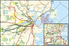
The Urban Ring was a proposed project of the Massachusetts Bay Transportation Authority and the Massachusetts Department of Transportation, to develop new public transportation routes that would provide improved circumferential connections among many existing transit lines that project radially from downtown Boston. The Urban Ring Corridor is located roughly one to two miles from downtown Boston, passing through the Massachusetts cities of Boston, Chelsea, Everett, Medford, Somerville, Cambridge, and Brookline. The project was expected to convert 41,500 car trips to transit trips daily.

<span class="mw-page-title-main">Washington Street Elevated</span> Former elevated railroad in Boston, Massachusetts

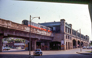
The Washington Street Elevated was an elevated segment of Boston's Massachusetts Bay Transportation Authority subway system, comprising the southern stretch of the Orange Line. It ran from Chinatown through the South End and Roxbury, ending in Forest Hills in Jamaica Plain, Boston.

<span class="mw-page-title-main">History of the MBTA</span> Story of mass transit in the Boston US area

The history of the Massachusetts Bay Transportation Authority (MBTA) and its predecessors spans two centuries, starting with one of the oldest railroads in the United States. Development of mass transportation both followed existing economic and population patterns, and helped shape those patterns.

The Massachusetts Bay Transportation Authority operates subway, bus, commuter rail, and ferry service in the Greater Boston region. Boston has some of the highest rates of non-motorized commuting in the United States, including high bicycle usage. The MBTA offers certain provisions for riders wishing to make part of their trips by bicycle. The agency allows bicycles to be carried on all fixed-route services except the Green Line and the Ashmont-Mattapan High Speed Line light rail lines, although they are restricted on the commuter rail and heavy rail subway services at peak hours. Bicycle storage areas are offered at many stations, with "Pedal and Park" locking bicycle cages at certain high-usage stations.

<span class="mw-page-title-main">North Station (subway)</span> Rapid transit station in Boston, Massachusetts, US

North Station is an underground MBTA subway station in Boston, Massachusetts. Served by the Massachusetts Bay Transportation Authority (MBTA) Green Line and Orange Line, it is connected to the North Station surface terminal used by MBTA Commuter Rail and Amtrak. The station is fully accessible.

References

  1. 1 2 "Transit Ridership Report Fourth Quarter 2023" (PDF). American Public Transportation Association. March 4, 2024. Retrieved March 14, 2024.
  2. "Ridership and Service Statistics" (PDF) (14th ed.). Massachusetts Bay Transportation Authority. 2014.
  3. "Transit Ridership Report Fourth Quarter 2023" (PDF). American Public Transportation Association. March 4, 2024. Retrieved March 14, 2024.
  4. "Boston used to have 24-hour train service. Will all-night MBTA service ever exist?". August 22, 2023.
  5. "Famous Firsts in Massachusetts". Commonwealth of Massachusetts. Archived from the original on February 8, 2007. Retrieved January 21, 2015.
  6. "New York Subway's "Remembering the Ninth Avenue El" article". Archived from the original on August 18, 2014. Retrieved September 4, 2017.
  7. Ferry, J. Amanda (May 20, 2003). "Boston's subway". Boston.com. Retrieved February 27, 2016.
  8. 1 2 3 Belcher, Jonathan. "Changes to Transit Service in the MBTA district" (PDF). Boston Street Railway Association.
  9. "Cambridge Seven Associates Website". C7a.com. Archived from the original on July 21, 2011.
  10. 1 2 Ba Tran, Andrew (June 2012). "MBTA Orange Line's 111th anniversary". Boston Globe. Archived from the original on July 21, 2017. The Everett-Forest Hills Main Line Elevated was renamed the Orange Line on August 25, 1965. The name comes from a section of Washington Street between Essex and Dover streets that had the name Orange Street until the early 19th century, said Clarke. However, according to architecture firm Cambridge Seven Associates, the Orange Line's color was a design choice after the yellow color option did not test well.
  11. Byrnes, Mark (September 17, 2018). "How Boston Got Its 'T'". CityLab . I remember sitting in my Cambridge office preparing for a meeting with the MBTA in which I would be proposing colored lines. I had markers in front of me and I chose red for the line that went to Harvard since it's a well-known institution whose main color is crimson. One line went up the North Shore of Boston up to the coastal areas, so it seemed obvious to call that the Blue Line. The line that serves Olmsted's Emerald Necklace was an obvious choice for green. And then the fourth line ended up being orange for no particular reason beyond color balance.
  12. Sanborn, George M. (1992). A Chronicle of the Boston Transit System. Massachusetts Bay Transportation Authority. Archived from the original on August 18, 2015. Retrieved September 17, 2016 via MIT.
  13. "Curiosity Carcards" (PDF). Massachusetts Bay Transportation Authority. 2012. Archived from the original (PDF) on June 13, 2018. Retrieved September 18, 2018.
  14. Robin Washington (February 25, 2015). "On the T, One Sized Doesn't Fit All". Boston Globe. Retrieved January 21, 2019.
  15. Discussion of rail intereconnections [ permanent dead link ]. The Red Line connection is at JFK/UMass, the Orange Line at Wellington (last used ca. 1981), and the Green Line at Riverside. Tractor trailer trucks may also be used to deliver train cars from the manufacturer. http://groups-beta.google.com/group/ne.transportation/browse_frm/thread/e6ba611be5abb7a/6c500ca982d60b28%5B%5D
  16. 1 2 "Subway Fares". Massachusetts Bay Transportation Authority. Retrieved March 29, 2023.
  17. "Reduced Fares". Massachusetts Bay Transportation Authority. Retrieved March 29, 2023.

    Notes

    1. There are 2 heavy-rail-exclusive stations which act as interchanges and use multiple heavy-rail lines, and were not counted more than once in this total: Downtown Crossing and State.
    2. This subtotal includes counting interchange stations between light and heavy-rail lines multiple times for every line they utilize.
    3. There are 12 stations which act as interchanges: 11 of them connect two lines, and 1 connects three (Downtown Crossing). For this reason, these were not counted more than once in this total: Tufts Medical Center, Chinatown, Boylston, Park Street, Downtown Crossing, South Station, State, Government Center, Haymarket, North Station, Airport, and Ashmont.