Islandia is an unincorporated community and former city in Miami-Dade County, Florida, United States. It is located in the upper Florida Keys on the islands of Elliott Key and other nearby keys, such as Totten Key. It was the only municipality in the Florida Keys not located in neighboring Monroe County. The population was 18 at the 2010 Census. Most residents of the city were National Park Service employees.

Biscayne Bay is a lagoon with characteristics of an estuary located on the Atlantic coast of South Florida. The northern end of the lagoon is surrounded by the densely developed heart of the Miami metropolitan area while the southern end is largely undeveloped with a large portion of the lagoon included in Biscayne National Park.

Interstate 195 (I-195) is a 4.4-mile-long (7.1 km) spur freeway connecting I-95 in the west with Miami Beach in the east. It crosses Biscayne Bay by traveling over the Julia Tuttle Causeway. The causeway is named after Miami founder Julia Tuttle.

The Venetian Causeway crosses Biscayne Bay between Miami on the mainland and Miami Beach on a barrier island in the Miami metropolitan area. The man-made Venetian Islands and non-bridge portions of the causeway were created by materials which came from the dredging of the bay. The Venetian Causeway follows the original route of the Collins Bridge, a wooden 2.5 mi (4 km) long structure built in 1913 by John S. Collins and Carl G. Fisher which opened up the barrier island for unprecedented growth and development.
State Road 913 is an access road between the village of Key Biscayne on the island of Key Biscayne and I-95 in Miami on the western end of Biscayne Bay. The only part that is state maintained is South 26th Road ; Miami-Dade County maintains the Rickenbacker Causeway across the Biscayne Bay and Virginia Key to Key Biscayne. Inside the village of Key Biscayne, the roadway is known as Crandon Boulevard after it crosses Bear Cut. Mile markers are posted along the entire route, with zero at the entrance to Bill Baggs Cape Florida State Park at the south end of Crandon Boulevard.

The Dolphin East-West Expressway is a 15-mile-long (24 km), six-lane, divided controlled-access highway, with the westernmost 14 miles (23 km) as an all-electronic tollway signed as State Road 836, and the easternmost 1.292 miles (2.079 km) between Interstate 95 (I-95) and SR A1A cosigned as Interstate 395 (I-395). The road currently extends from just north of the intersection of Southwest 137th Avenue and U.S. Highway 41 (US 41) in Tamiami, eastward past the Homestead Extension of Florida's Turnpike and Miami International Airport, before intersecting I-95, becoming I-395 and ending at SR A1A in Miami at the west end of the MacArthur Causeway. The Dolphin Expressway is maintained and operated by the Miami-Dade Expressway Authority (MDX), while the I-395 section is maintained by the Florida Department of Transportation (FDOT). The Dolphin Expressway from the Palmetto Expressway to I-95 opened in 1969, with the I-395 section opening in 1971, the extension to the HEFT opening in 1974 and a second western extension opening in 2007.

Card Sound Bridge is a high-rise toll causeway connecting southern Miami-Dade County and northern Monroe County. It is one of only two ways that motorists can leave or enter the Florida Keys. The toll for two-axle automobiles is USD $1.50 if paid via SunPass. The prior toll plaza was demolished during hurricane Matthew and has been replaced with a toll-by-plate plaza. The toll fee will be charged by plate automatically and sent via the mail to the address on the vehicle registration. The cashless all-electronic tolling system replaced the previous staffed toll booth on October 20, 2018. The toll fee is waived upon evacuating the Keys for hurricanes or in instances in which US 1 is impassable.

State Road 934 runs for 13.1 miles (21.1 km) from State Road 826 in Medley to SR A1A in Miami Beach. It is a major east–west highway in the Miami metropolitan area.

State Road 856 (SR 856), also known as the William Lehman Causeway, is a 1.704-mile-long (2.742 km) causeway connecting Biscayne Boulevard in Aventura and Collins Avenue (SR A1A) in Sunny Isles Beach, Florida.

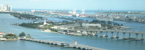
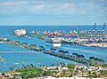
Government Cut is a manmade shipping channel between Miami Beach and Fisher Island, which allows better access to the Port of Miami in Miami, Florida. Before the cut was established, a single peninsula of dry land stretched from what is now Miami Beach to what is now Fisher Island, and boats destined for the port at the mouth of the Miami River had to pass around Cape Florida, to the south of Key Biscayne.

Interstate 95 (I-95) is the main Interstate Highway of Florida's Atlantic Coast. It begins at a partial interchange with U.S. Highway 1 (US 1) just south of downtown Miami, and heads north past Daytona Beach, through Jacksonville, and to the Georgia state line at the St. Marys River near Becker. The route also passes through the cities of Fort Lauderdale, West Palm Beach, and Titusville.

The Rickenbacker Causeway is a causeway that connects Miami, Florida to the barrier islands of Virginia Key and Key Biscayne across Biscayne Bay.

The Venetian Islands are a chain of artificial islands in Biscayne Bay in the cities of Miami and Miami Beach, Florida. The islands are, from west to east: Biscayne Island (Miami), San Marco Island (Miami), San Marino Island, Di Lido Island, Rivo Alto Island, and Belle Isle. Flagler Monument Island remains an uninhabited picnic island, originally built in 1920 as a memorial to railroad pioneer Henry Flagler. The islands are connected by bridges from the Miami mainland to Miami Beach.

U.S. Highway 1 (US 1) in Florida runs 545 miles (877 km) along the state's east coast from Key West to its crossing of the St. Marys River into Georgia north of Boulogne and south of Folkston. US 1 was designated through Florida when the U.S. Numbered Highway System was established in 1926. The road is maintained by the Florida Department of Transportation (FDOT).

Crandon Park is an 808-acre (3.27 km2) urban park in metropolitan Miami, occupying the northern part of Key Biscayne. It is connected to mainland Miami via the Rickenbacker Causeway.

Palm Island is a neighborhood in the city of Miami Beach on a man-made island in Biscayne Bay, Florida, United States; just south of Hibiscus Island. It is a residential neighborhood with high property values, solely accessible by land via the MacArthur Causeway. The entire island has an area of 82 acres (33 ha).

The Port of Miami Tunnel is a 4,200-foot (1,300 m) bored, undersea tunnel in Miami, Florida. It consists of two parallel tunnels that travel beneath Biscayne Bay, connecting the MacArthur Causeway on Watson Island with PortMiami on Dodge Island. It was built in a public–private partnership between three government entities—the Florida Department of Transportation, Miami-Dade County, and the City of Miami—and the private entity MAT Concessionaire LLC, which was in charge of designing, building, and financing the project and holds a 30-year concession to operate the tunnel.

Hibiscus Island is a neighborhood in the city of Miami Beach on a man-made island in Biscayne Bay, Florida, United States. Hibiscus Island lies just north of Palm Island. It is an exclusive residential neighborhood with relatively high property values. The island is accessible via the MacArthur Causeway.

The Greater Miami area, composed of the three counties of Miami-Dade, Broward, and Palm Beach, also known collectively as South Florida, is home to a wide variety of public and private transportation systems. These include heavy rail mass transit (Metrorail), commuter rail (Tri-Rail), automated guideway transit (Metromover), highways, two major airports and seaports, as well as three county-wide bus networks, which cover the entire urbanized area of South Florida. Census and ridership data show that Miami has the highest public transportation usage of any city in Florida, as about 17% of Miamians use public transportation on a regular basis, compared to about 4% of commuters in the South Florida metropolitan area. The majority of public transportation in Miami is operated by Miami-Dade Transit (MDT), which is currently the largest transit system in Florida and was the 14th largest transit system in the United States in 2011.