
The Missouri River is the longest river in North America. Rising in the Rocky Mountains of the Eastern Centennial Mountains of Southwestern Montana, the Missouri flows east and south for 2,341 miles (3,767 km) before entering the Mississippi River north of St. Louis, Missouri. The river drains a sparsely populated, semi-arid watershed of more than 500,000 square miles (1,300,000 km2), which includes parts of ten U.S. states and two Canadian provinces. Although nominally considered a tributary of the Mississippi, the Missouri River above the confluence is much longer than the Mississippi above the confluence and carries a comparable volume of water. When combined with the lower Mississippi River, it forms the world's fourth longest river system.
A tributary, or affluent, is a stream or river that flows into a larger stream or main stem river or a lake. A tributary does not flow directly into a sea or ocean. Tributaries and the main stem river drain the surrounding drainage basin of its surface water and groundwater, leading the water out into an ocean. The Irtysh is a chief tributary of the Ob river and is also the longest tributary river in the world with a length of 4,248 km (2,640 mi). The Madeira River is the largest tributary river by volume in the world with an average discharge of 31,200 m3/s (1.1 million cu ft/s).
The Tanana River is a 584-mile (940 km) tributary of the Yukon River in the U.S. state of Alaska. According to linguist and anthropologist William Bright, the name is from the Koyukon (Athabaskan) tene no, tenene, literally "trail river".
The Yampa River flows 250 miles (400 km) through northwestern Colorado in the United States. Rising in the Rocky Mountains, it is a tributary of the Green River and a major part of the Colorado River system. The Yampa is one of the few free-flowing rivers in the western United States, with only a few small dams and diversions.

The White River is a Missouri River tributary that flows 580 miles (930 km) through the U.S. states of Nebraska and South Dakota. The name stems from the water's white-gray color, a function of eroded sand, clay, and volcanic ash carried by the river from its source near the Badlands. Draining a basin of about 10,200 square miles (26,000 km2), about 8,500 square miles (22,000 km2) of which is in South Dakota, the stream flows through a region of sparsely populated hills, plateaus, and badlands.

The Kuskokwim River or Kusko River is a river, 702 miles (1,130 km) long, in Southwest Alaska in the United States. It is the ninth largest river in the United States by average discharge volume at its mouth and seventeenth largest by basin drainage area. The Kuskokwim River is the longest river system contained entirely within a single U.S. state.

The Koyukuk River is a 425-mile (684 km) tributary of the Yukon River, in the U.S. state of Alaska. It is the last major tributary entering the Yukon before the larger river empties into the Bering Sea.

The Verde River is a major tributary of the Salt River in the U.S. state of Arizona. It is about 170 miles (270 km) long and carries a mean flow of 602 cubic feet per second (17.0 m3/s) at its mouth. It is one of the largest perennial streams in Arizona.

The Thompson River is the largest tributary of the Fraser River, flowing through the south-central portion of British Columbia, Canada. The Thompson River has two main branches, the South Thompson River and the North Thompson River. The river is home to several varieties of Pacific salmon and trout. The area's geological history was heavily influenced by glaciation, and the several large glacial lakes have filled the river valley over the last 12,000 years. Archaeological evidence shows human habitation in the watershed dating back at least 8,300 years. The Thompson was named by Fraser River explorer, Simon Fraser, in honour of his friend, Columbia Basin explorer David Thompson. Recreational use of the river includes whitewater rafting and angling.
Drainage density is a quantity used to describe physical parameters of a drainage basin. First described by Robert E. Horton, drainage density is defined as the total length of channel in a drainage basin divided by the total area, represented by the following equation:
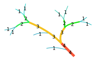
In mathematics, the Strahler number or Horton–Strahler number of a mathematical tree is a numerical measure of its branching complexity.
The Pine River flows along the Minnesota-Ontario border a short distance, primarily within the Boundary Waters Canoe Area Wilderness and La Verendrye Provincial Park. The river is part of the Winnipeg River drainage basin and is a tributary of the Granite River.

The Bill Williams River is a 46.3-mile-long (74.5 km) river in west-central Arizona where it, along with one of its tributaries, the Santa Maria River, form the boundary between Mohave County to the north and La Paz County to the south. It is a major drainage westwards into the Colorado River of the Lower Colorado River Valley south of Hoover Dam and Lake Mead, and the drainage basin covers portions of northwest, and west-central Arizona. The equivalent drainage system paralleling the east–west lower reaches of the Bill Williams is the Gila River, which flows east-to-west across central Arizona, joining the Colorado River in the southwest at Yuma. The confluence of the Bill Williams River with the Colorado is north of Parker, and south of Lake Havasu City.
A hydrological code or hydrologic unit code is a sequence of numbers or letters that identify a hydrological feature like a river, river reach, lake, or area like a drainage basin or catchment.
The stream order or waterbody order is a positive whole number used in geomorphology and hydrology to indicate the level of branching in a river system.

The Black River is a 114-mile-long (183 km) river in the White Mountains of the U.S. state of Arizona. It forms southwest of Alpine and flows southwest then northwest to meet the White River west of Fort Apache. The merged streams form the Salt River, a major tributary of the Gila River.

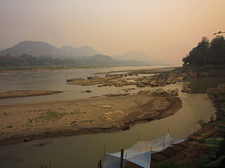
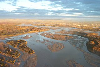
In geomorphology, drainage systems, also known as river systems, are the patterns formed by the streams, rivers, and lakes in a particular drainage basin. They are governed by the topography of land, whether a particular region is dominated by hard or soft rocks, and the gradient of the land. Geomorphologists and hydrologists often view streams as part of drainage basins. This is the topographic region from which a stream receives runoff, throughflow, and its saturated equivalent, groundwater flow. The number, size, and shape of the drainage basins varies and the larger and more detailed the topographic map, the more information is available.
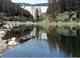
The North Fork Clearwater River is a major tributary of the Clearwater River in the U.S. state of Idaho. From its headwaters in the Bitterroot Mountains of eastern Idaho, it flows 135 miles (217 km) westward and is dammed by the Dworshak Dam just above its mouth in north-central Idaho. Draining a rugged watershed of 2,462 square miles (6,380 km2), the river has an average flow of over 5,600 cubic feet per second (160 m3/s), accounting for a third of the discharge from the Clearwater basin. The river drains parts of Clearwater, Shoshone, Latah, and Idaho counties. Most of the watershed is managed by the U.S. Forest Service. Some of the fish of the river include westslope cutthroat trout, rainbow trout, mountain whitefish, and the threatened bull trout. It also has smallmouth bass and a kokanee salmon run, both from Dworshak Reservoir. The North Fork drainage is home to grizzly bears, cougars, deer, moose, black bear, elk, grey wolves, and osprey. The river used to have a large steelhead run before the implementation of Dworshak Dam. The North Fork of the Clearwater is located within the Clearwater National Forest


