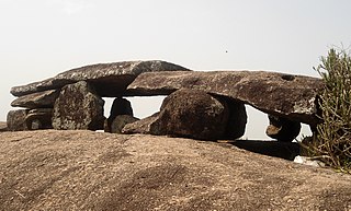
Mandasa is a village in Srikakulam district of the Indian state of Andhra Pradesh. Mandasa is also known by the name Manjusha in Odia. It was ruled by erstwhile odia zamindar Rajamani royal family during British Raj. Srinivasa Rajamani was the famous Ruling chief Rajah of this estate.

Srikakulam district is one of the twenty-six districts of the Indian state of Andhra Pradesh, located in the Uttarandhra region of the state, with its headquarters located at Srikakulam. It is one of the six districts, located in the extreme northeastern direction of the state. It was formerly known as Chicacole, and was under Ganjam district till 1936 April 1, then merged under Vizagapatam district. Srikakulam district forms the core area of Kalinga where most of its historical capitals like Kalinganagari, pithunda, Dantapuram are located.

Amadalavalasa is a town in Srikakulam district of the Indian state of Andhra Pradesh. It is a municipality and also the mandal headquarters of Amadalavalasa mandal. The town is spread over an area of 19.65 km2 (7.59 sq mi), which is under the jurisdiction of Visakhapatnam Metropolitan Region Development Authority. Srikakulam Road railway station is situated at Amadalavalasa.
Ranastalam is a village adjoining National Highway 16 in Srikakulam district of the Indian state of Andhra Pradesh. There are nearly 55 villages in Ranastalam mandal.Jrpuram kon damulagam kosta pydibheemavaram kammasigadam etc.

The River Nagavali also known as Langulya is one of the main rivers of Southern Odisha and Andhra States in India, between Rushikulya and Godavari basins.
Burja or Boorja is a village in Srikakulam district of the Indian state of Andhra Pradesh. Burja is located near River Nagavali.
Etcherla is a village in Srikakulam district of the Indian state of Andhra Pradesh. It is the Mandal headquarters of Etcherla mandal. Most of the people in this region speak Telugu.

Gara is a village in Srikakulam district of the Indian state of Andhra Pradesh. It is also the mandal head quarters of Gara Mandal, Srikakulam District, AP.
Jalamuru is a village in Srikakulam district of the Indian state of Andhra Pradesh. Jalumuru mandal is bordered by Narasannapeta, Sarubujjili, Saravakota and Kotabommali mandals of Srikakulam district.
Kanchili is a village in Srikakulam district of the Indian state of Andhra Pradesh.
Kaviti is a village in Srikakulam district of the Indian state of Andhra Pradesh. Kaviti mandal is bordered by Ichchapuram mandal to the north, Kanchili and Sompeta mandals to the south, Odisha state to the west and the Bay of Bengal to the east.

Narasannapeta is a census town in Srikakulam district of the Indian state of Andhra Pradesh. It is the mandal headquarters of Narasannapeta mandal in Srikakulam revenue division. 43 villages are there under the administrative division of Narasannapeta.

Pathapatnam is a town in Srikakulam district of the Indian state of Andhra Pradesh. It is located in Pathapatnam mandal of Palakonda revenue division. Pathapatnam is located on the border of Srikakulam district of Andhra Pradesh and Gajapati district of Odisha. Parlakhemundi, the headquarters of Gajapati District, can be considered as twin town of Pathapatnam because of its close proximity. It is located around 65 km from srikakulam. It was the old capital of Paralakhemundi Gajapati Maharajah of his erstwhile kingdom.
Polaki is a village in Srikakulam district of Andhra Pradesh in India.
Regidi Amadalavalasa is a village in Srikakulam district of the Indian state of Andhra Pradesh. It is located in Regidi Amadalavalasa mandal of Palakonda revenue division.
Santhabommali is a village in Srikakulam district of the Indian state of Andhra Pradesh.
Saravakota is a village in Srikakulam district of the Indian state of Andhra Pradesh. It is located in Saravakota mandal of Palakonda revenue division.
Sarubujjili is a village in Srikakulam district of the Indian state of Andhra Pradesh. Sarubujjili mandal is bordered by Burja, Seethampeta, Hiramandalam, Jalumuru and Narasannapeta mandals of Srikakulam district.
Vajrapu-kotturu is a village in Srikakulam district of the Indian state of Andhra Pradesh. Vajrapukotturu mandal is bordered by Mandasa, Palasa, Nandigam and Santha Bommali mandals of Srikakulam district and has a long coastline off Bay of Bengal. Bendi Gedda river joins the sea after forming a lagoon in this mandal area.
Srikakulam mandal is one of the 38 mandals in Srikakulam district of the Indian state of Andhra Pradesh. It is under the administration of Srikakulam revenue division and the headquarters are located at Srikakulam. The mandal is bounded Amudalavalasa, Etcherla and Gara mandals. A portion of it lies on the banks of Vamsadhara River and Bay of Bengal.


