Srikakulam district

Last updated

Srikakulam district
700 CE Mukhalingeswara Temples Group, Kalinga architecture, Mukhalingam, Andhra Pradesh - 84.jpg
2nd century BCE to 8th century CE Salihundam Buddhist site, Andhra Pradesh - 54.jpg
Ancient Buddhist site, Kalingapatnam Andhra Pradesh - 12.jpg
11th century Kurmanatha Swamy Temple, Srikurmam Andhra Pradesh 02.jpg
Megalithic Dolmen at Dannanapeta 03.jpg
Category: Srimukhalingam Temple at Mukhalingam, Ruined Stupa near Salihundam, Kurmanathaswamy temple, Srikurmam, Dolmens near Dannanapeta, Buddhist site at Kalingapatnam
Srikakulam in Andhra Pradesh (India).svg
Srikakulam district in Andhra Pradesh
Srikakulam district
Interactive map outlining district
CountryFlag of India.svg  India
State Flag placeholder.svg Andhra Pradesh
Region Uttarandhra
Headquarters Srikakulam
Administrative Divisions
Government
   Lok Sabha constituencies Srikakulam, Vizianagaram
   Assembly constituencies 08
Area
[1]
  Total4,591 km2 (1,773 sq mi)
Population
 (2011) [2]
  Total2,191,437
  Density463/km2 (1,200/sq mi)
   Rank6th
   Urban
[3] :14
373,746
  Households
681,330
   Sex ratio
1,015 (females per 1,000 males)
Languages
  Official Telugu
Literacy
  Literates1495381
Time zone UTC+5:30 (IST)
Postal Index Number
532xxx
Area codes +91–8942
ISO 3166 code IN-AP
Vehicle registration AP–39 (from 30 January 2019) [4]
Website srikakulam.ap.gov.in

Srikakulam district is one of the twenty-six districts of the Indian state of Andhra Pradesh, located in the Uttarandhra region of the state, with its headquarters located at Srikakulam. [5] [6] It is one of the six districts, located in the extreme northeastern direction of the state. It was formerly known as Chicacole , and was under Ganjam district till 1936 April 1, then merged under Vizagapatam district . Srikakulam district forms the core area of Kalinga where most of its historical capitals like Kalinganagari, pithunda, Dantapuram are located.

Contents

History

Iron Age megalithic Dolmen at Dannanapeta near Amudalavalasa Megalithic Dolmen at Dannanapeta 03.jpg
Iron Age megalithic Dolmen at Dannanapeta near Amudalavalasa

Prehistory

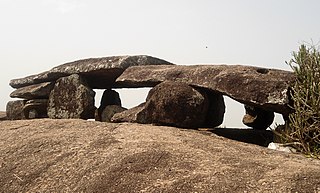
Evidence of early historic man and his activities during the Stone Age and Iron Age have been discovered at Sangamayya Konda and Dannanapeta. The speciality of Dannanapeta Iron Age megalithic site is a large single capstone as a dolmen with 36 ft in length and 14 ft in width and 2 ft thickness. Sailada Hills consists of 36 upright rocks and natural caves used for habitation by Iron Age man in Amudalavalasa mandal of the district. [7]

Jainism and Buddhism

Salihundam Historic Buddhist Remains Site Salihundam Historic Buddhist Remains 3 by GPuvvada 2010.jpg
Salihundam Historic Buddhist Remains Site

Evidences of Jain monuments and Buddhist remnants were discovered near Sangamayya Konda. Jain rock beds were discovered at Dannanapeta near Amudalavalasa in the district. Salihundam is a famous Buddhist remnants site on the south bank of River Vamsadhara 5 kilometres west of Kalingapatnam and 18 kilometres from Srikakulam town. [8]

Post Independence

Srikakulam District was carved out in 1950 by bifurcating it from Visakhapatnam District. It remained unaffected in its territorial jurisdiction for some time. But in November 1969 the district lost 63 villages from Saluru Taluk and 44 villages from Bobbili Taluk on account of their transfer to the then newly constituted Gajapathinagaram Taluk of Visakhapatnam District.

In May 1979, the district underwent major territorial changes with the formation of a new district with headquarters at Vizianagaram which involved transfer of Salur, Bobbili, Parvathipuram and Cheepurupalli Taluks to the new district. Srikakulam's culture is a blend of traditional festivals, food, music and theatres. [9]

Geography

Srikakulam district occupies an area of 4,591 square kilometres (1,773 sq mi), [10] comparatively equivalent to Trinidad and Tobago. [11] It is within the geographic coordinates of 18°-20’ and 19°-10’ N and 83°-50’ and 84°-50’ E. The district is skirted to a distance by Kandivalasagedda, Vamsadhara and Bahuda at certain stretches of their courses while a line of heights of the great Eastern Ghats run from the northeast. Vizianagaram district and Parvathipuram Manyam district flanks in the south and west while Odisha bounds it on the north and Bay of Bengal on the East. Srikakulam district can be divided into two main distinct natural divisions. A portion of Srikakulam district is plain terrain with intense agriculture and the other is rocky and hilly terrain covered with forests. Some of the Mahendragiri Hills covers Srikakulam district. Most of the forest area of the plain terrain has been damaged by intense agriculture. Kotthuru, Hiramandalam, Pathapatnam, Kalingadal reservoir and some other areas are still covered with dense forests. Srikakulam is 100 km (62 mi) north of Visakhapatnam. It has a population of 2,703,114 of which 10.98% is urban as of 2001. Srikakulam district has the longest coastline (about 193 km (120 mi)) in the state of Andhra Pradesh.

Major rivers flowing through the district are River Nagavali, River Vamsadhara, Mahendratanaya, Champavati, Bahuda, Kumbhikota Gedda, Suvarnamukhi, Vegavati, Gomukhi. The Nagavali and Vamsadhara are the major rivers in Srikakulam district. These two river basins together constitute about 5% of the area. The Mahendratanaya and Bahuda rivers are two minor river basins in the district. Others are Benjigedda, Peddagedda, Kandivalasa gedda. Major irrigation projects on these rivers — Vamsadhara Project, Narayanapuram Anicut, Thotapalli Regulator — and some medium projects at Pydigam Project, Onigadda provide a total ayacut of 69,373 acres (280.74 km2).

Demographics

Historical population
YearPop.±% p.a.
19011,060,467    
19111,101,199+0.38%
19211,123,461+0.20%
19311,222,767+0.85%
19411,333,341+0.87%
19511,405,792+0.53%
19611,555,369+1.02%
19711,769,968+1.30%
19811,959,352+1.02%
19912,321,126+1.71%
20012,537,593+0.90%
20112,703,114+0.63%
source: [12]

According to the 2011 census Srikakulam district has a population of 2,703,114, roughly equal to the nation of Kuwait [13] or the US state of Nevada. This gives it a ranking of 147th in India (out of a total of 640). The district has a population density of 462 inhabitants per square kilometre (1,200/sq mi). Its population growth rate over the decade 2001–2011 was 6.38%. [14] Srikakulam has a sex ratio of 1014 females for every 1000 males, and a literacy rate of 62.3%. [15]

Religions in Srikakulam district (2011) [16]
ReligionPercent
Hinduism
98.79%
Christianity
0.54%
Other or not stated
0.67%

After reorganization the district had a population of 21,91,437, with a sex ratio of 1014 females to every 1000 males. 373,746 (17.05%) lives in urban areas. Scheduled Castes and Scheduled Tribes made up 1,85,890 (8.48%) and 94,371 (4.31%) of the population respectively. [15] :86–89

Languages of Srikakulam district (2011) [17]

   Telugu (92.34%)
   Odia (6.18%)
   Saora (0.92%)
  Others (0.56%)

At the time of the 2011 census, 92.34% of the population spoke Telugu, 6.18% Odia and 0.92% Sora as their first language. [17]

Household indicators

According to 2007–08, International Institute for Population Sciences, [18] 86.9% had access to electricity, 70.4% had drinking water, 18.5% toilet facilities, and 47.2% lived in a pucca (permanent) home. [18] 31.5% of girls wed before the legal age of 18 and 90.1% of interviewees carried a BPL card. [18]

Politics

Srikakulam (Lok Sabha constituency), Vizianagaram (Lok Sabha constituency)

The seven Assembly segments of Srikakulam Lok Sabha and One Assembly segment of Vijayanagaram Lok Sabha constituency are:

Constituency numberNameReserved for
(SC/ST/None)
Lok Sabha constituency
1 Ichchapuram None Srikakulam
2 Palasa None
3 Tekkali None
4 Pathapatnam None
5 Srikakulam None
6 Amadalavalasa None
7 Narasannapeta None
8 Etcherla None Vizianagaram

Cities And Towns

There are one municipal corporation, three municipalities, two nagar panchayats and seven census towns. The municipal corporation in the district is Srikakulam and three municipalities in the district are Amadalavalasa, Ichchapuram, Palasa-Kasibugga. The six census towns are Balaga, Hiramandalam, Narasannapeta, Ponduru, Sompeta, Tekkali.


Largest cities or towns in Srikakulam District
As per the 2011 Census
Rank Division Municipal pop.
1 Srikakulam Srikakulam Division 125,953
2 Palasa Palasa Division 57,507
3 Amudalavalasa Srikakulam Division 39,799
4 Ichchapuram Palasa Division 36,478
5 Tekkali Tekkali Division 28,637
6 Narasannapeta Srikakulam Division 26,280
7 Sompeta Palasa Division 18,778
8 Pathapatnam Tekkali Division 15,954
9[[{{{city_9}}}]][[{{{div_9}}}]]{{{pop_9}}}
10[[{{{city_10}}}]][[{{{div_10}}}]]{{{pop_10}}}

Administrative divisions

Satellite view of Srikakulam district Srikakulam.png
Satellite view of Srikakulam district

The district is divided into 3 revenue divisions: Palasa, Srikakulam and Tekkali, which are further subdivided into a total of 30 mandals, each headed by a sub-collector. [19]

Mandals

The list of 30 mandals in Srikakulam district, divided into 3 revenue divisions, is given below. [20] [21]

Erstwhile Talukas

Before Formation of Mandals, Administration was done through Taluka system. Erstwhile Talukas in district is given below.

In 1978, the number of talukas in Srikakulam district was increased from 14 to 19. Later in 1985, 19 Talukas were divided into 60 mandals, out of which 14 talukas were in Srikakulam further bifurcated into 38 Mandals.

S.No.Erstwhile Talukas

in 1971

Newly Formed Talukas

in 1978

Newly Formed Mandals

in 1985

1SrikakulamSrikakulamSrikakulam, Gara,
AmadalavalasaAmadalavalasa, Burja [part], Sarubujjili,
2PalakondaPalakondaPalakonda, Vanagara, Burja [part], Seethampeta,
RajamVeeraghattam, Regidi, Rajam, Santhakaviti,
3PathapatnamPathapatnamPathapatnam, Kothuru [part], Hiramandalam[part], Saravakota, Meliaputti, Tekkali [part],
HiramandalamHiramandalam[part], Bhamini, Kothuru [part], Lakshminarsupeta
4NarasannapetNarasannapetNarasannapet, Polaki [part],
KotabommaliKotabommali [part], Polaki [part], Jalumuru, Santhabommali [part],
5TekkaliTekkaliTekkali [part], Kotabommali [part], Santhabommali [part], Nandigam [part], Varjapukothuru [part]
PalasaPalasa, Nandigam [part], Varjapukothuru [part],
6SompetaSompetaSompeta, mandasa,
7IchchapuramIchchapuramIchchapuram, Kaviti,
8CheepurupalleRanasthalamRanasthalam, Laveru,
PonduruGanguvari sigadam, Pondhuru, Etcherla,
***Cheepurupalle [New Vizianagaram]Vizianagaram District
9Bobbili***Bobbili [New Vizianagaram]
10Salur***Salur [New Vizianagaram]
11Parvathipuram***Parvathipuram [New Vizianagaram]

Parliamentary and Assembly constituencies

There are three Parliamentary Constituencies and 10 assembly constituencies in Srikakulam district. Parliamentary constituencies include Srikakulam, Araku, and Vizianagaram. [22]

The 10 Assembly Constituencies are Amadalavalasa, Rajam, Tekkali, Ichchapuram, Palasa, Narasannapeta, Palakonda, Pathapatnam, Srikakulam and Etcherla.

Municipalities in District

S.No.City / TownCivic Status of TownNo.of

Wards

Municipality

Formation year

2011 Census Population2001 Census Population1991 Census Population1981 Census Population1971 Census Population1961 Census Population1951 Census Population
1 Srikakulam Municipal Corporation5018561,37,9441,17,32088,88368,14545,17935,07124,212
2 Palasa-Kasibugga Municipality Grade - 231200057,50749,89933,05723,73717,439----
3AmadalavalasaMunicipality Grade - 227198739,79937,93134,39518,00513,842----
4 Ichapuram Municipality Grade - 323198636,49332,66229,56419,15215,85012,96111,390

Villages

Economy

Khadi weaving at Ponduru, Srikakulam district Khadi Weaving at Ponduru 06.JPG
Khadi weaving at Ponduru, Srikakulam district

The gross district domestic product (GDDP) of the district is 19,942 crore (US$2.5 billion) and it contributes 3.8% to the gross state domestic product (GSDP). For FY 2013–14, the per capita income at current prices was 57,174 (US$720). The primary, secondary and tertiary sectors of the district contribute 4,855 crore (US$610 million), 4,114 crore (US$520 million) and 10,973 crore (US$1.4 billion) respectively. [24]

Tribal communities such as the Saora and Jatapus still practise the traditional podu system of cultivation. [25]

Dr. Reddy's Laboratories, a major pharmaceutical company, is at Pydibhimavaram.

Transport

APSRTC bus depot locations Srikakulam district APSRTC Depot map.png
APSRTC bus depot locations

The total road length of state highways in the district is 959 km (596 mi). [26] Andhra Pradesh State Road Transport Corporation runs bus services to all the major cities and towns of the state from the district. Major railway stations in the district include Amudalavalasa, Srikakulam Road railway station, Palasa railway station ( major station) Naupada, Ichchapuram and Sompeta etc.

Culture

The district is renowned for the brassware products namely, Budithi Bell and Brass Craft, which are made at Budithi village. These are registered as geographic indication from Andhra Pradesh. [27]

The district has many people from fields like film industry, music, art and architecture etc. Among the notable people are Vaddadi Papaiah, J. V. Somayajulu, Gidugu Venkata Ramamoorty, Sarat babu, LV Revanth(Indian idol), Rao Ramesh, Rao gopala Rao, Sai kumar, Pingali Nagendrarao, and Kalipatnam Ramarao.[ citation needed ]

Sports

Kodi Rammurthy Naidu (body builder), Karnam Malleswari (Olympic medalist), Pujari Sailaja in weight lifting are famous people from the district.

Education

The primary and secondary school education is imparted by government, aided and private schools, under the School Education Department of the state. [28] [29] As per the school information report for the academic year 2015–16, there are 3,875 schools. They include, 55 government, 2,833 mandal and zilla parishads, 1 residential, 573 private, 14 model, 32 Kasturba Gandhi Balika Vidyalaya (KGBV), 85 municipal and 282 other types of schools. [30] The number of students enrolled in primary, upper primary and high schools of the district is 371,472. [31]

The only university in the district is Dr. B.R. Ambedkar University, Srikakulam [32] and medical colleges are Rajiv Gandhi Institute of Medical Sciences in Srikakulam town, GEMS—Great Eastern Medical Speciality and Hospital in Ragolu village.

Temples

There are seven temples under the management of Endowments Department. [33]

Trust controlled Temples
S.noTempleMandalVillage
1Sri Kodanda Rama Swamy TempleSRIKAKULAMBALAGA (RURAL)
2Sri Maninageswara Swamy TempleSRIKAKULAMKALLEPALLE
3Sri Kothamma Ammavari TempleKOTABOMMILIKOTABOMMILI
4Sri Neelamani Durga Ammavari TemplePATHAPATNAMPATHAPATNAM
5Sri Yendala Mallikarjuna Swamy TempleTEKKALIRAAVI VALASA
6Sri Hatakeswara Swamy TempleSRIKAKULAM Singupuram
7Sri kurmam TempleGARASRI KURMAM
8Sri Suryanarayana Swamy TempleARASAVELLIARASAVELLI

Important Commodities Produced / Manufactured in the District

Following are the towns & villages with respective commodities produced across the district. [34]

S#TownCommodities
1SrikakulamJute, Bricks, Iron Articles
2PalasaCashew Nuts, Coir Ropes, Sugar
3IchchapuramCoir Ropes, Bricks, Stone Carving
4SompetaCashew Nuts, Baskets
5HiramandalamGroundnut Oil
6TekkaliAluminium Moulding
7AmadalavalasaSugar
8NarasannapetaJaggery
9BalagaJute, Bricks
10PonduruTextiles, Ground Nut

Notable people

Related Research Articles

<span class="mw-page-title-main">Vizianagaram district</span> District of Andhra Pradesh in India

Vizianagaram district is one of the six districts in the Uttarandhra region of the Indian state of Andhra Pradesh with its headquarters located at Vizianagaram. The district was once the part of ancient Kalinga.Saripilli Dibbilingeswara temple, Jayathi Mallikarjuna Temple are the finest examples of ancient Eastern Ganga Dynasty built monuments in the district. The district is bounded on the east by the district of Srikakulam, north by Parvathipuram Manyam south by Visakhapatnam, Anakapalli, southeast by the Bay of Bengal, and west by Alluri Sitharama Raju district. It was formed on 1 June 1979, with some parts carved from the neighbouring districts of Srikakulam and Visakhapatnam. The district is named after the princely state of Vizianagaram. In 2011, it was the least populous district in Andhra Pradesh.

<span class="mw-page-title-main">Visakhapatnam district</span> District in Andhra Pradesh, India

Visakhapatnam district is one of the six districts in the Uttarandhra region of the Indian state of Andhra Pradesh, headquartered at Visakhapatnam. It is one of the twenty-six districts in Andhra Pradesh state. The district shares borders within the north and east, Vizianagaram district and South Anakapalli district in the south-west and Bay of Bengal in the south.

<span class="mw-page-title-main">Bobbili</span> Town in Andhra Pradesh, India

Bobbili is a town in Vizianagaram district of the Indian state of Andhra Pradesh.

<span class="mw-page-title-main">Amudalavalasa</span> Town in Andhra Pradesh, India

Amadalavalasa is a town in Srikakulam district of the Indian state of Andhra Pradesh. It is a municipality and also the mandal headquarters of Amadalavalasa mandal. The town is spread over an area of 19.65 km2 (7.59 sq mi), which is under the jurisdiction of Visakhapatnam Metropolitan Region Development Authority. Srikakulam Road railway station is situated at Amadalavalasa.

<span class="mw-page-title-main">Ichchapuram</span> Town in Andhra Pradesh, India


Ichchapuram is a town in the Srikakulam district of the Indian state of Andhra Pradesh. The town is located nearly 142 km from the district capital, Srikakulam. It is located on the border of Odisha and Andhra Pradesh. Ichchapuram municipality is the largest urban local body in the Srikakulam district. It had a population of 36,493 as of 2011.

<span class="mw-page-title-main">Sompeta</span> Census Town in Andhra Pradesh, India

Sompeta is a census town in Srikakulam district of the Indian state of Andhra Pradesh. It is the mandal headquarters of Sompeta mandal in Tekkali revenue division.

<span class="mw-page-title-main">Nellimarla</span> Census town in Andhra Pradesh, India

Nelli-marla is a census town in Vizianagaram district of the Indian state of Andhra Pradesh. It is in Nellimarla mandal of Vizianagaram revenue division.

<span class="mw-page-title-main">Nagavali River</span> River in India

The River Nagavali also known as Langulya is one of the main rivers of Southern Odisha and Andhra States in India, between Rushikulya and Godavari basins.

Kotabommali is a mandal in the Srikakulam district of the Indian state of Andhra Pradesh.

<span class="mw-page-title-main">Narasannapeta</span> Census Town in Andhra Pradesh, India

Narasannapeta is a census town in Srikakulam district of the Indian state of Andhra Pradesh. It is the mandal headquarters of Narasannapeta mandal in Srikakulam revenue division. 43 villages are there under the administrative division of Narasannapeta.

<span class="mw-page-title-main">Palasa</span> Place in Andhra Pradesh, India

Palasa is one of the twin towns located in the Srikakulam district of Andhra Pradesh, India. The town is situated between Srikakulam and Berhampur. It is categorized as the second grade municipality. Also the town serves as the headquarters of Palasa Mandal.

<span class="mw-page-title-main">Pathapatnam</span> Place in Andhra Pradesh, India

Pathapatnam is a town in Srikakulam district of the Indian state of Andhra Pradesh. It is located in Pathapatnam mandal of Palakonda revenue division. Pathapatnam is located on the border of Srikakulam district of Andhra Pradesh and Gajapati district of Odisha. Parlakhemundi, the headquarters of Gajapati District, can be considered as twin town of Pathapatnam because of its close proximity. It is located around 65 km from srikakulam. It was the old capital of Paralakhemundi Gajapati Maharajah of his erstwhile kingdom.

Saravakota is a village in Srikakulam district of the Indian state of Andhra Pradesh. It is located in Saravakota mandal of Palakonda revenue division.

<span class="mw-page-title-main">Tekkali</span> Census Town in Andhra Pradesh, India

Tekkali is a census town in Srikakulam district of the Indian state of Andhra Pradesh. It is the mandal headquarters of Tekkali mandal and Tekkali revenue division and is located at a distance of 51 km from the district headquarters.

<span class="mw-page-title-main">Vizagapatam district (Madras Presidency)</span>

Vizagapatam District was a district in the Madras Presidency of British India. Covering an area of 44,600 square kilometres (17,222 sq mi) and sub-divided into 22 taluks.

Harishchandrapuram Assembly constituency was a constituency of the Andhra Pradesh Legislative Assembly, India until 2008 in Srikakulam district.

Kothuru Assembly constituency was an ST-reserved constituency of the Andhra Pradesh Legislative Assembly, India until 2008 in Srikakulam district.

Vunukuru Assembly constituency was an assembly constituency of the Andhra Pradesh Legislative Assembly, India. It was one of 10 constituencies in the Srikakulam district.

<span class="mw-page-title-main">Jarjangi</span> Indian village

Jarjangi is a Panchayath village in Kotabommali mandal, Srikakulam district, in the Indian state of Andhra Pradesh. The Postal Index Code of this village is 532195.

Palasa revenue division is an administrative division in the Srikakulam district of the Indian state of Andhra Pradesh. It is one of the three revenue divisions in the district and comprises 8 mandals. It was formed on 4 April 2022.

References

  1. correspondent, dc (26 January 2022). "Government at doorstep: Andhra Pradesh to have 26 new districts". Deccan Chronicle. Retrieved 21 April 2022.
  2. "District Census Hand Book – Srikakulam" (PDF). Census of India . Registrar General and Census Commissioner of India.
  3. "District Census Hand Book – Srikakulam" (PDF). Census of India . Registrar General and Census Commissioner of India . Retrieved 14 June 2019.
  4. "New 'AP 39' code to register vehicles in Andhra Pradesh launched". The New Indian Express. Vijayawada. 31 January 2019. Archived from the original on 3 February 2019. Retrieved 9 June 2019.
  5. "Srikakulam | Andhra Pradesh | DISTRICTS OF INDIA". districts.nic.in. Retrieved 11 May 2019.
  6. "Population of AP districts(2011)" (PDF). ap.gov.in. p. 14. Archived from the original (PDF) on 12 November 2013. Retrieved 25 May 2014.
  7. "Iron Age habitation found in Srikakulam". The Hindu. 16 October 2011. Retrieved 14 June 2014.
  8. "Remnants of Jain monuments found". 21 August 2009. Retrieved 14 June 2014.
  9. Law, Gwillim (25 September 2011). "Districts of India". Statoids. Retrieved 11 October 2011.
  10. Srivastava, Dayawanti; et al., eds. (2010). "States and Union Territories: Andhra Pradesh: Government". India 2010: A Reference Annual (54th ed.). New Delhi, India: Additional Director General, Publications Division, Ministry of Information and Broadcasting (India), Government of India. pp. 1111–1112. ISBN   978-81-230-1617-7.
  11. "Island Directory Tables: Islands by Land Area". United Nations Environment Program. 18 February 1998. Retrieved 11 October 2011. Melville Island 5,765km2
  12. Decadal Variation In Population Since 1901
  13. US Directorate of Intelligence. "Country Comparison:Population". Archived from the original on 13 June 2007. Retrieved 1 October 2011. Kuwait 2,595,62
  14. "District Census 2011". Census2011.co.in. 2011. Retrieved 30 September 2011.
  15. 1 2 "District Census Hand Book – Srikakulam" (PDF). Census of India . Registrar General and Census Commissioner of India.
  16. "Population by Religion - Andhra Pradesh". censusindia.gov.in. Registrar General and Census Commissioner of India. 2011.
  17. 1 2 "Table C-16 Population by Mother Tongue: Andhra Pradesh". Census of India . Registrar General and Census Commissioner of India.
  18. 1 2 3 "District Level Household and Facility Survey (DLHS-3), 2007-08: India. Andhra Pradesh" (PDF). International Institute for Population Sciences and Ministry of Health and Family Welfare. 2010. Retrieved 3 October 2011.
  19. "ULB Lists". Commissioner and Directorate of Municipal Administration. Retrieved 26 May 2017.
  20. "Mandals | District Srikakulam, Government of Andhra Pradesh | India" . Retrieved 21 April 2022.
  21. "New AP Map: Check Out Biggest and Smallest Districts in Andhra Pradesh". Sakshi Post. 3 April 2022. Retrieved 6 May 2022.
  22. "District-wise Assembly-Constituencies". ceoandhra.nic.in.
  23. "Komarthi Population (2020/2021), Village in Narasannapeta Mandal, Pincode". www.indiagrowing.com. Retrieved 3 January 2022.
  24. "Economy of Srikakulam District". Andhra Pradesh Economic Development Board. Retrieved 25 April 2017.
  25. von Fürer-Haimendorf, Christoph (1982). Tribes of India: The Struggle for Survival. University of California Press. pp. 77–78. ISBN   978-0-520-04315-2.
  26. "Existing State Highways" (PDF). Andhra Pradesh Road Development Corporation. Government of Andhra Pradesh. p. 1. Archived from the original (PDF) on 20 September 2018. Retrieved 11 May 2019.
  27. "State Wise Registration Details of G.I Applications" (PDF). Geographical Indication Registry. p. 3. Archived from the original (PDF) on 1 February 2016. Retrieved 4 February 2016.
  28. "School Education Department" (PDF). School Education Department, Government of Andhra Pradesh. Archived from the original (PDF) on 27 December 2015. Retrieved 7 November 2016.
  29. "The Department of School Education – Official AP State Government Portal". www.ap.gov.in. Archived from the original on 7 November 2016. Retrieved 7 November 2016.
  30. "School Information Report". Commissionerate of School Education. Government of Andhra Pradesh. Archived from the original on 8 November 2016. Retrieved 8 November 2016.
  31. "Student Information Report". Commissionerate of School Education. Child info 2015–16, District School Education – Andhra Pradesh. Archived from the original on 22 May 2015. Retrieved 8 November 2016.
  32. "Welcome :: Dr.B.R.Ambedkar University, Srikakulam, AP. INDIA". brau.in. Archived from the original on 24 June 2011.
  33. "Trust Boards Abstract". AP Temples Portal, Government of Andhra Pradesh. Retrieved 24 July 2018.
  34. https://censusindia.gov.in/2011census/dchb/2811_PART_A_DCHB_SRIKAKULAM.pdf [ bare URL PDF ]