Kadapa district

Last updated

Kadapa district
YSR district
16th century Kodandarama temple, Vontimitta, Andhra Pradesh India - 25.jpg
10th to 15th century Chennakesava temples group, Pushpagiri, Andhra Pradesh India - 02.jpg
Sri Soumyanathaswamy Temple, Nandalur.JPG
Dry deciduous forest in Sri Lankamalleswara Wildlife Sanctuary JEG8320.jpg
Clockwise from top-left: Kodanda Rama Temple in Vontimitta, Chennakeshava temple in Pushpagiri, Gandikota Fort temple, Hills in Sri Lankamalleswara Wildlife Sanctuary, Soumyanathaswamy Temple, Nandalur
Nickname: 
Gadapa
YSR in Andhra Pradesh (India).svg
Location of YSR district in Andhra Pradesh
Kadapa district
Coordinates: 14°28′30″N78°49′19″E / 14.475°N 78.822°E / 14.475; 78.822
CountryFlag of India.svg  India
State Flag placeholder.svg Andhra Pradesh
Region Rayalaseema
Established1808
1st Reorganized1953
2nd Reorganized4th April 2022
Named for Y. S. Rajasekhara Reddy
Headquarters Kadapa
Administrative Divisions
Government
   District collector V. Vijay Ramaraju, IAS
   Lok Sabha
Lok Sabha list
   Assembly
Area
[1]
  Total11,228 km2 (4,335 sq mi)
  Rank7th
Population
 (2011) [1]
  Total2,060,654
  Rank18th
  Density188/km2 (490/sq mi)
   Rank21st
   Urban
[1]
809,290
   Rural
[1]
1,251,364
  Households
706,204
   Sex ratio
985 (females per 1,000 males)
Languages
  Official Telugu
Urdu
Literacy
  Literates1716766
Time zone UTC+5:30 (IST)
Postal Index Number
516xxx
Area codes +91–8562
ISO 3166 code IN-AP
Vehicle registration AP-04 (former) AP–39 (from 30 January 2019) [2]
Website kadapa.ap.gov.in

Kadapa district (officially: YSR district; [3] formerly: Cuddapah district [4] ) is one of the twenty six districts in the Indian state of Andhra Pradesh. In 2022 reorganisation of Andhra Pradesh districts, the district boundary is largely restricted to Kadapa parliamentary constituency area. It is also one of the eight districts in the Rayalaseema region. Kadapa is the administrative headquarters for this district. [5]

Contents

Barytes, Lime Stone, Asbestos and Uranium are major mineral resources of the district. The district is home to many religious and historic places of interest. Kodandarama Temple at Vontimetta, Chennakesava temple of Pushpagiri, Siddavatam Fort and Gandikota gorge are some of the famous places.

Etymology

YS Rajasekhara Reddy (YSR) Postal stamp YS Rajasekhara Reddy 2010 stamp of India.jpg
YS Rajasekhara Reddy (YSR) Postal stamp

The old records of the district reveal that Kadapa was previously called Gadapa which translated in Telugu to threshold. The ancient village of Kadapa with its large tank and temple of Lord Venkateswara at Devuni Kadapa was convenient camping place for the myriads of pilgrims travelling to the holy shrine of Tirupati. On 19 August 2005, the nomenclature of “Cuddapah” had been changed to “Kadapa” by the Government of A.P. It was renamed as Y.S.R District during the year 2010, in honour of Y. S. Rajasekhara Reddy, the former chief minister of United Andhra Pradesh. [6]

History

This region was part of Maurya Empire, Satavahana dynasty, Chola dynasty, Pallava dynasty, Pandya dynasty, Bana Kingdom, Rashtrakuta dynasty, Kakatiya dynasty, Vijayanagara Empire, Maratha Empire, Kingdom of Mysore and Carnatic Sultanate during the course of its history upto medieval period. [7] Later on it was ruled as part of British East India company.

Prehistory

Many paleolithic sites were found in Kadapa district, as the surroundings of Jammalamadugu, Mailavaram Dam [8] and Gandikota. Some megalithic burial sites were explored near Porumamilla, Sankhavaram and at Yellatur [9] village near Kadapa. The surroundings of Vontimitta are also noted as Megalithic cultural sites.

Paleolithic rock paintings found at Chintakunta caves [10] near Muddanur in Kadapa district are said to be the second largest group of paintings in India after Bhimbetika rock art paintings. The rock paintings with mystic figures are also found at Dappalle village [8] near Mylavaram Dam in Jammalamadugu Taluk of the district.

This region was ruled by the Mauryan Empire and the Satavahana Empire (Andhras). [11] Buddhism flourished for many years along the banks of the rivers Cheyyeru and Penna. Jainism also had a place in Kadapa district history; the remnants of a buried Jain temple were found at Danavulapadu [12] village on the banks of the Penna.

Medieval history

In the later half of 13th Century, this region was ruled from Vallur by Ambadeva. During his rule, the land survey was carried out. Subsequently, a Kakatiya King Pratapa rudra ruled the district with Warangal as the capital. Jyothi village located in Siddavatam mandal has 108 Shiva lingas on the bank of the river Penna which are dated to the rule of Kakatiyas. [13]

In A.D.1309, Allah-ud-din Khilji defeated PratapaRudra and took over the region. [14] In 1344, the confederation of Hindu kings overthrew the Muslim rule. This led to the formation of Vijayanagar Empire, who ruled the area for two centuries. Gandikota fort located on the bank of the Penna river was the citadel of Pemmasani Nayaks, commanders of Vijayanagar army. After the fall of Vijayanagar kingdom, this region came under the rule of Qutub shahis, who later became part of Mughal empire.

As part of Qutub Shahi rule, Riza Quli Beg under the title of Nek naam Khan and his successors ruled the region [15] with certain degree of autonomy. Later Abdul Nabi Khan was appointed as the governor of the district in the year 1714. The Marathas invaded and defeated the nawabs of Kurnool and Kadapa in 1740. Hyder Ali took over Gurramkonda and Kadapa from Marathas in 1760. He appointed his brother-in-law Mir Saheb in Kadapa district. Thus Mir Saheb became son first ruler of the district. This region was transferred to Nizam by the treaties of Mysore and Srirangapatnam. [14]

Modern history

Nizam of Hyderabad ceded it to the British in 1800, and in 1808 it was divided to form Kadapa (spelt Cuddapah by the British) and Bellary districts. [16] Munro was appointed as principal Collector over the ceded districts. Munro subjugated over 80 Palegars, instituted revenue collection system through which he secured the finances. [17] The district headquarters were situated in Siddavatam but moved to Kadapa in 1812. [18] On April 4, 2022, Annamayya district was formed from the parts of erstwhile YSR Kadapa district and others.

Demographics

As of 2011 census, Kadapa district has a population of 2,884,524. [19] This gives it a ranking of 132 in India (out of a total of 640). The district has a population density of 188 inhabitants per square kilometre (490/sq mi) . Its population growth rate over the decade 2001–2011 was 10.87%. It has a sex ratio of 984 females for every 1000 males, and a literacy rate of 67.88%. [19]

Economy

The Gross District Domestic Product (GDDP) of the district for FY 2013-14 is 26,342 crore (US$3.3 billion) and contributes 5% to the Gross State Domestic Product (GSDP). For the FY 2013–14, the per capita income at current prices was 70,821 (US$890). The primary, secondary and tertiary sectors of the district contribute 6,204 crore (US$780 million), 6,935 crore (US$870 million) and 13,203 crore (US$1.7 billion) respectively. [20]

Geography

Kadapa district occupies an area of 11,228 square kilometres (4,335 sq mi). [1] This district is bordered on north by Nandyal district, south by Annamayya district, east by SPS Nellore district and west by Sri Sathya Sai district and Anantapur district. [1]

The main rivers in this district are Penna, Kundu,Chitravathi, Papagni, and Sagileru. [21] Vellikonda, Palakonda, Nallamalai, Lankamalai and Yerramalai are the major hill ranges in the district. [22] The forests of Kadapa comprise fuel forests up to an elevation of 800 feet, red sanders lying between the elevation of 800 feet and 2,000 feet and Shorea Eugenia at elevations of more than 2,000 feet. [23] The district has a forest cover of 28.49%. [24]

Fauna

The Bonnet monkey (Macaca Radiata) also known as the Madras Langur is common. Tiger and Panther can be seen in the interior areas of Nallamalas, Lankamalas, Palakonda-Seshachalam and Velikonda forests. mungoose, jackal, fox, wolves, wild dogs, bear, the Malabar squirrel, porcupine, the Indian antelope, Indian gazelle, Blue bull, sambar, deer and wild pigs are also found in the forests. Grey partridge known as Kamju, the quail, the Jungle fowl, the dove, pigeon and wild goose are the other common birds found in this district. [23]

Soil

Red ferruginous and Black soils are common in the district. Fertile black clay soil occupies 23.7% area. [25]

Minerals

Barytes, Lime Stone and Asbestos are the major minerals. Napa slabs, road metal, building stone, marble, are also found in the district. [25] Limestone is available in Yerraguntla. National Mineral Development Corporation is extracting asbestos in Brahman palli and barytes in Mangampet. Kadapa is also famous for its stone called "kadapa stone" used in building construction and for slabs especially in south India. In Tummalapalle, there are 49,000 tonnes of confirmed uranium deposits which are mined and processed locally. [26] [27]

Climate

The summer season is spread over March–May. This is followed by the South-West monsoon during June - September. North East monsoon season is spread over October–November. December–February is the winter or cold season. The average annual rainfall is 572.25 mm. The rainfall generally increases from the North-West to the South-East. October is the month with maximum rainfall. [25]

Demographics

Religions in Kadapa district based on 2011 census [28]
ReligionPercent
Hinduism
83.02%
Islam
15.40%
Christianity
1.02%
Other or not stated
0.56%

After reorganization,the district had a population of 20,60,654, of which 809,290 (39.27%) lived in urban areas. [1] Kadapa district had a sex ratio of 985 females per 1000 males. Scheduled Castes and Scheduled Tribes make up 3,37,860 (16.40%) and 40,994 (2.03%) of the population respectively. [29] Hinduism is the dominant religion with 83.02% followers followed by Islam with 15.40% followers.

Languages of Kadapa district based on 2011 Census [30]

   Telugu (84.66%)
   Urdu (14.37%)
  Others (0.97%)

Based on the 2011 census, as computed for the revised district boundaries of 2022, 84.66% of the population spoke Telugu and 14.37% Urdu as their first language. [30]

Administrative divisions

Satellite view of YSR district YSR district.png
Satellite view of YSR district

The district is divided into 4 revenue divisions: Badvel, Jammalamadugu, Kadapa and Pulivendula, which are further subdivided into a total of 36 mandals, each headed by a sub-collector. [31] [32]

Mandals

The list of 36 mandals in YSR district, divided into 4 revenue divisions, is given below. [33]

Cities and towns

There are 1 municipal corporation, 5 municipalities, [34] 2 nagar panchayats in the district.

Municipal Bodies in YSR District
Ciy/TownCivil statusRevenue DivisionPopulation (2011)
Kadapa Municipal CorporationKadapa344,893
Proddatur Municipality Special GradeJammalamadugu217,786
Badvel Municipality Grade-2Badvel70,626
Pulivendula Municipality Grade-1Pulivendula70,650
Jammalamadugu MunicipalityJammalamadugu61,218
Mydukur Municipality Grade-3Jammalamadugu45,790
Yerraguntla Nagar PanchayatKadapa32,574
Kamalapuram Nagar PanchayatKadapa20,623

^ upgraded in 2019

Politics and government

The district is covered by Kadapa (fully) and Rajampet (partially) parliamentary constituencies. The assembly constituencies covering the district are given below. [35]

Constituency numberNameReserved for
(SC/ST/None)
Parliamentary constituency
124 Badvel SC Kadapa
131 Jammalamadugu None
126 Kadapa None
130 Kamalapuram None
133 Mydukur None
132 Proddatur None
129 Pulivendula None
125 Rajampet (partial) None Rajampet

Kadapa district is considered to be a bastion of the ruling YSR Congress party.

Economy

Agriculture contributes a major share to the economy. Paddy, Groundnut, Sunflower, Cotton, Betel Leaves, Mango, Papaya, Banana, Lemon and Sweet Orange are the major crops cultivated in the district. As per 2019-20, the gross cropped area in the district is 2,53,458 hectares, out of which 1,14,410 hectares were irrigated. [36]

Irrigation

Brahmamsagar Brahmam sagar2.jpg
Brahmamsagar

Starting at Sunkesula Dam on Tungabadra river Kurnool - Cuddapa Canal (K. C. Canal) flows through the district providing water to 40 km2 (15 sq mi) of cultivable land. The main source of drinking water to this district is Galeru Nagari Sujala Sravanthi Project Canal.

There is one major irrigation project on the river Penna at Mylavaram. There are 4 medium irrigation projects namely Lower Sagileru Project, Upper Sagileru Project, BrahmamSagar Project and Pulivendula Branch Canal. [36] These form several reservoirs such as Brahmamsagar Reservoir, Mylavaram Dam Reservoir, Annamayya Project reservoir and Gandikota Reservoir. [37]

Energy

Rayalaseema Thermal Power Station Rayalaseema Thermal Power Station.jpg
Rayalaseema Thermal Power Station

Rayalaseema Thermal Power Station with a capacity of 1650MW is one of the biggest coal based power plant. It is near to Proddatur.

Industries

The district has 29 large and medium scale industries with an investment of Rs. 10,22,943 crores providing employment to 19,410. It also has 2335 small scale units employing 21,294 persons with an investment of Rs. 688.59 Cr. [36] Tummalapalle uranium mine was commissioned in 2012 to extract Uranium from ore.

Transport

Roadways

The district has 864.02 km (536.88 mi) of State Highway and 325.28 km (202.12 mi) of National Highway. The district is having 6174.69 KMs of BT roads 727.03 of CC road and 1458.48 KMs of Metal roads. [38] National Highway 40, National Highway 716 and National Highway 67 pass through the district.

Railways

The district has broad-gauge railway line of 195.13 km (121.25 mi). There are 14 railway stations covering 7 Mandals. [36] Kadapa, Yerraguntla Junction , Proddatur and Jammalamadugu are the major railway stations from the district under Guntakal railway division.

Airways

Kadapa Airport is a small airport located north west to Kadapa city. Tirupati Airport is the nearest bigger airport at a distance of 139 Kms from Kadapa city.

Education

JNTUACEP entrance, Pulivendula JNTUACEP Entrance.jpg
JNTUACEP entrance, Pulivendula
RIMS Medical College, Kadapa RIMS Medical college block.jpg
RIMS Medical College, Kadapa

The district has 2001 Primary Schools, 468 Upper Primary Schools, 683 High Schools, 142 Junior Colleges, 48 Degree Colleges. It also has 120 Polytechnics, Engineering colleges and Govt. Aided Professional & Special Education Colleges. Rajiv Gandhi Institute of Medical Sciences (RIMS), one Dental college, one Homoeopathic Medical college, one Veterinary college and one IIIT centre at Rajiv Knowledge Valley, Idupulapaya of Vempalle mandal are also present in the district. [36]

JNTUA College of Engineering, Pulivendula is one of the government engineering colleges in the district. Yogi Vemana University offers P.G. courses for general education. CP Brown library in Kadapa is famous for its collection of manuscripts collected by CP Brown. [39]

Tourism

Siddavatam (Sidhout) at a distance of 25 Km Kadapa town is famous for its fort and temples. Matli Maharajas built the fort in A.D.1303. Hyder Ali destroyed it in 1770.[ citation needed ] The fort is spread over an area of 30 acres and has 17 bastions. It is called the southern gate way of Srisailam. [18] Brahmamgari Matham (B. Mattam), is the place where SreeVeerabrahmendra Swamy, a 17th century saint and clairvoyant entered Jeevasamadhi. The annual prayer festival is held for 6 days in the month of Vysakha.

Kodandarama Temple dedicated to the god Rama, is located in Vontimitta. The temple is built in Vijayanagara architectural style and is dated to the 16th century. This inspired Pothana to compose Andhra Maha Bhagavatham. It is located at a distance of 25 kilometres (16 mi) from Kadapa. [40] Some of the other tourist attractions are Chennakesava temple of Pushpagiri, Madhavaraya temple at Gandikota.

Gandikota gorge was formed in the Erramala range of hills. The river Penna flows in the gorge with a width of 100 m.

Notable people

Related Research Articles

<span class="mw-page-title-main">Vontimitta</span> Temple Town in Andhra Pradesh, India

Vontimitta or Ekasilanagaram, is a village in Kadapa district of the Indian state of Andhra Pradesh. It is located in the Vontimitta Mandal of the Kadapa revenue division.

<span class="mw-page-title-main">Anantapur district</span> District of Andhra Pradesh in India

Anantapur district, officially Anantapuramu district, is one of the eight districts in the Rayalaseema region of the Indian state of Andhra Pradesh. The district headquarters is located in Anantapur city. It is one of the driest places in South India. In the year 2022, as part of re-organisation of districts, Sri Sathya Sai district was carved out.

<span class="mw-page-title-main">Kadapa</span> City Corporation in Andhra Pradesh, India

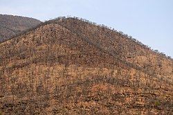
Kadapa is a city in the southern part of Andhra Pradesh, India. It is located in the Rayalaseema region, and is the district headquarters of YSR Kadapa district. As of the 2022 Census of India, the city had a population of 466,000, a 2.42% increase from 2021. It is located 8 kilometres (5.0 mi) south of the Penna River. The city is surrounded on three sides by the Nallamala and Palkonda Hills lying on the tectonic landscape between the Eastern and Western ghats. Black and Red ferrous soils occupy the region. The city is nicknamed "Gadapa" ('threshold') since it is the gateway from the west to the hills of Tirumala.

<span class="mw-page-title-main">Proddatur</span> City in Andhra Pradesh, India

Proddatur (1915) is a city in the YSR Kadapa District of Andhra Pradesh, located on the banks of the Penna River. The city is a municipality, and also the mandal headquarters of Proddatur mandal. It is the second-largest town in former Kadapa District. It is the oldest municipality which formed before Independence.

<span class="mw-page-title-main">Jammalamadugu</span> Town in Andhra Pradesh, India

Jammalamadugu is a town in Municipality and Revenue Division in YSR Kadapa district of the Indian state of Andhra Pradesh. It is in Jammalamadugu mandal of Jammalamadugu revenue division. It has many old historical sites and one of the top tourist destination in Andhra Pradesh.

<span class="mw-page-title-main">Gandikota</span> Place in Andhra Pradesh, India

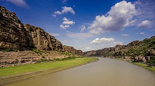
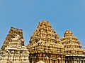
Gandikota is a village and historical fort on the right bank of the Penna river, 15 km from Jammalamadugu in Kadapa district, Andhra Pradesh, India. The fort was the centre of power for various dynasties, such as the Kalyani Chalukyas, Pemmasani Nayakas, and the Golconda Sultanate. A sand fort was constructed by Kaka Raja, Vassals of Kalyani Chalukya rulers. Various additions of Islamic architecture were made during subsequent Muslim rule.

Dommara Nandyal is a census town in Mylavaram Mandal, Kadapa district, Andhra Pradesh, India. Dommara Nandyal is under the constituency of Jammalamadugu. Dommara Nandyal is situated along the bank of the Penna River. Mylavaram dam is constructed just 3 km away from it, that supplies water for drinking. Dommara Nandyal is also famous for people making silk sarees with their own hands. Veparala and Moragudi, beside of Dommaranadyala, are also the handloom towns.

<span class="mw-page-title-main">Yerraguntla</span> Town in Andhra Pradesh, India

Yerraguntla is a town and Nagar Panchayat in YSR Kadapa District. It is an industrial area in YSR Kadapa district, Andhra Pradesh. It is located in Yerraguntla mandal of Kadapa revenue division.

Badvel is a Municipality in Kadapa district of the Indian state of Andhra Pradesh. Badvel Town is located in Two mandals. It is the headquarters of Badvel revenue division. Major portion of Town comes under Badvel mandal and remaining portion of Town comes under Gopavaram Mandal. It comes under Badvel revenue division.

<span class="mw-page-title-main">Mydukur</span> Town in Andhra Pradesh, India

Mydukur is a Municipality in YSR Kadapa district of the Indian state of Andhra Pradesh. It is located in Mydukur mandal of Badvel revenue division. Mydukur is located on Main Junction of NH-40 and NH-67. It is a junction point for Kurnool, Kadapa, Proddatur, Markapur, and Nellore Highways.

Pulivendula is a town located in the YSR Kadapa district, Andhra Pradesh, India. It is a small town which became 3rd grade municipality in 2008 from nagar Panchayat.

Bramhamgari Matham is a village in Kadapa district of the Indian state of Andhra Pradesh. It is located in Brahmamgari Matham mandal of Badvel revenue division. It is a pilgrimage centre. The village is known as Sri Pothuluri Veera Brahmandra Swamy who entered into a samadhi alive in front of his disciples. He is considered to be the author of the Kālagnānaṁ, a book of predictions. His prophetic texts are also known as the Govinda Vakyas.

Khajipet Sunkesula is a village in Kadapa district of the Indian state of Andhra Pradesh. It is located in Khajipet mandal of Badvel revenue division.

<span class="mw-page-title-main">Nandalur</span> Village in Andhra Pradesh, India

Nandalur is a village in Annamayya district of the Indian state of Andhra Pradesh. It is located in Nandalur mandal of Rajampeta revenue division. It is 10 km from Rajampet and 42 km from the District headquarters of the Cuddapah district on the State Highway connecting Cuddapah with Tirupati. It is located on the Cuddapah-Chennai highway, 38 km from Cuddapah and 11 km from Rajampeta. It is also close to other pilgrimage centres in Cuddapah district like Ontimitta, Polatala, Attirala and the famed birthplace of Sri Annamacharya, Tallapaka. It has an average elevation of 151 meters.

<span class="mw-page-title-main">Kondapuram, Kadapa district</span> Town in Andhra Pradesh, India

Kondapuram is a town in YSR Kadapa district of the Indian state of Andhra Pradesh. It is located in Kondapuram mandal of Jammalamadugu revenue division.

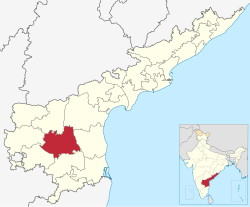
Kadapa revenue division is an administrative division in the Kadapa district of the Indian state of Andhra Pradesh. It is one of the 4 revenue divisions in the district which consists of 9 mandals under its administration. Kadapa is the administrative headquarters of the division.

<span class="mw-page-title-main">Jammalamadugu revenue division</span> Revenue division in YSR district in Andhra Pradesh, India

Jammalamadugu revenue division is an administrative division in the Kadapa district of the Indian state of Andhra Pradesh. It is one of the 4 revenue divisions in the district which consists of 7 mandals under its administration.Proddatur is the largest town in jammalamadugu revenue division.

<span class="mw-page-title-main">Annamayya district</span> District of Andhra Pradesh, India

Annamayya district is one of the eight districts in the Rayalaseema region of Andhra Pradesh, established in 2022. Rayachoti is the district administrative headquarters, and Madanapalle is the most populated city in the district.

Pottipadu is a village in the YSR Kadapa district of Andhra Pradesh State, India, lies 97 KM west of Kadapa, the district headquarters. The state’s capital, Vijayawada, is 436 KM away. The postal code of Pottipadu is 516464 and its post office is in Lavanur.

Pulivendula revenue division is an administrative division in the Kadapa district of the Indian state of Andhra Pradesh. It is one of the 4 revenue divisions in the district and consists of seven mandals under its administration. Pulivendula is the administrative headquarters of the division.

References

  1. 1 2 3 4 5 6 7 CPO 2022, p. VI.
  2. "New 'AP 39' code to register vehicles in Andhra Pradesh launched". The New Indian Express. Vijayawada. 31 January 2019. Archived from the original on 28 July 2019. Retrieved 9 June 2019.
  3. "YSR District". Kadapa district. Retrieved 10 May 2023.
  4. "District Census Hand Book –" (PDF). Census of India . Registrar General and Census Commissioner of India . Retrieved 11 April 2023.:2
  5. "Six districts in Andhra reel under drinking water crisis". The New Indian Express. Vijayawada. 13 May 2019. Retrieved 14 June 2019.
  6. "Ex-Andhra Pradesh CM YSR's native district Kadapa to be named after him". The Times of India. 18 June 2010. Archived from the original on 21 February 2020. Retrieved 1 May 2021.
  7. CPO 2022, p. III.
  8. 1 2 Thapar, B.K., ed. (1980). Indian Archaeology 1976–77–A Review (PDF). New Delhi: Archaeological Survey of India, Government of India. Archived from the original (PDF) on 8 May 2012.
  9. Murty, M. L. K. (2003). Comprehensive History and Culture of Andhra Pradesh: Pre- and protohistoric ... ISBN   9788125024750.
  10. Subramanyam, M.V. (25 July 2012). "Second largest rock art painting site explored". The Hindu. Chennai, India.
  11. Lakshmi, V. Swarajya (1982). A Descriptive Grammar of Cuddapah Dialect. Telugu Akademi. p. 2.
  12. "Archaeological Survey of India". ap.nic.in. Archived from the original on 4 March 2016. Retrieved 14 May 2013.
  13. "Mysterious cases of Hindu temples that will shock you". Speakingtree.in. 18 January 2016. Retrieved 10 May 2023.
  14. 1 2 CPO 2022, p. IV.
  15. "The Career(s) and Memory of Neknam Khan in Seventeenth-Century Deccan". researchgate.net. 1 January 2014. Retrieved 10 May 2023.
  16. The Imperial Gazetteer of India, Volume 7. Oxford: Clarendon Press. 1908. pp. 158–76.
  17. CPO 2022, p. V.
  18. 1 2 "Siddavatam Fort". AP Tourism. Retrieved 10 May 2023.
  19. 1 2 "District Census Hand Book – YSR Kadapa" (PDF). Census of India . Registrar General and Census Commissioner of India.
  20. "Economy of Kadapa District". Andhra Pradesh Economic Development Board. Retrieved 25 April 2017.
  21. CPO 2022, p. VIII-IX.
  22. CPO 2022, p. VI-VII.
  23. 1 2 CPO 2022, p. IX.
  24. Annam, Bandhavi (14 January 2022). "Andhra Pradesh stands first in increasing forest cover". The New Indian Express. Archived from the original on 23 October 2022. Retrieved 3 December 2023.
  25. 1 2 3 CPO 2022, p. X.
  26. "Tummalapalle uranium mill to start operation by March 2011". Article from the Times of India. WISE Uranium Project. 24 October 2010. Retrieved 19 July 2011.
  27. "India: 'Massive' uranium find in Andhra Pradesh". BBC News – South Asia. BBC. 19 July 2011. Retrieved 19 July 2011.
  28. "Population by Religion - Andhra Pradesh". censusindia.gov.in. Registrar General and Census Commissioner of India. 2011.
  29. CPO 2022, p. XVIII.
  30. 1 2 "Table C-16 Population by Mother Tongue: Andhra Pradesh". Census of India . Registrar General and Census Commissioner of India.
  31. CPO 2022, p. XXII.
  32. "AP cabinet approves two new revenue divisions". Deccan Chronicle. 7 April 2022. Retrieved 3 May 2022.
  33. "Mandal | District YSR(Kadapa), Government of Andhra Pradesh | India". YSR District. Archived from the original on 4 October 2023. Retrieved 27 January 2024.
  34. CPO 2022, p. XXIII.
  35. "District-wise Assembly-Constituencies". ceoandhra.nic.in.
  36. 1 2 3 4 5 CPO 2022, p. XI.
  37. "Krishna water released into Gandikota reservoir". The Hindu. Retrieved 19 March 2017.
  38. CPO 2022, p. XI-XII.
  39. "CP Brown Library in Kadapa, a treasure trove for researchers in various fields". The New Indian Express. 19 October 2020. Retrieved 10 May 2023.
  40. CPO 2022, p. XII-XIV.
  41. Proceedings of the Andhra Pradesh Oriental Conference, First Session, Andhra Saraswatha Parishat, Hyderabad, May 1977. The Conference. 1979. p. 131. Kalagnana is a special type of discipline very popular in Andhra Desa because of the famous Kalagnanam of Sri Potuluri Veerabrahmendhra swami written in Telugu. It forecasts many incidents which are proved to be correct by the posterity.

Bibliography