Transport in Andhra Pradesh

Last updated

Andhra Pradesh is well connected with various destinations in India, as well as other countries. It has road, rail, airways. With a long coast of Bay of Bengal and many sea ports, it flourishes in sea trade as well. The state has one of the largest railway junctions at Vijayawada [1] and Visakhapatnam Port being one of the largest cargo handling seaport. [2]

Contents

Road

Toll gate on Hyderabad - Vijayawada National Highway 65 Toll gate on Vijayawada - Hyderabad highway.jpg
Toll gate on Hyderabad - Vijayawada National Highway 65

Andhra Pradesh has an extensive road network of 123,334 km (76,636 mi) with various types of roads such as, national highways, state highways, district roads etc. [3] The road network of the state is maintained by Andhra Pradesh Road Development Corporation, under the Roads and Buildings Department of the state. [4] [5]

National and state highways

The state has a total of 4,422.53 km (2,748.03 mi) of national highways. [6] NH 16 is the longest national highway with a length of 1,024 km (636 mi) and runs from Srikakulam district to Nellore district. [7] The highway forms a part of Golden Quadrilateral Project undertaken by National Highways Development Project and a part of AH 45 of Asian Highway Network. [8] [9]

Total network of state highways is 7,255 km (4,508 mi). [10] and 19,783 km (12,293 mi) of major district roads. Out of 91,994 km (57,162 mi) of other type of roads, there are 21,740.90 km (13,509.17 mi) of roads in the urban local bodies and municipal roads cover 19,118.97 km (11,879.98 mi). [11]

Expressways

Some of the highways are developed as Expressways in PPP model. Notable among these are:

Bus

Eluru-Chintalapudi APSRTC bus near Janampeta Eluru-Chintalapudi APSRTC bus near Janampeta.jpg
Eluru-Chintalapudi APSRTC bus near Janampeta

The Andhra Pradesh State Road Transport Corporation (APSRTC) operates bus services and is the primary mode of public transport in the state, which is owned by the state government. As of February 2017, it had a total of 11,918 buses with 970 bus shelters and connecting over 14,000 villages in over 3,000 routes. [12] The headquarters of APSRTC is located at NTR Administrative Block of RTC House in Pandit Nehru bus station of Vijayawada. [13] [14]

Apart from government run APSRTC, there are also many private buses operating in the state. [15] Auto rickshaws and cabs are also a common mode of transport, with the recent introduction of She Autos, driven by women. [16]

Freight

The transport of goods in the state depends mainly on lorries, mini trucks and auto rickshaws. [17] APSRTC, as a joint venture with Alloy Nitrides Ltd. was established in the year 1976, used for transportation of unaccompanied luggage, parcel/packets by their buses. [18]

Railways

Loco shed at Visakhapatnam railway station Loco trip shed at Visakhapatnam train Station.jpg
Loco shed at Visakhapatnam railway station

Andhra Pradesh has a total railway route of 3703.25 km. [19] The rail density of the state is 16.59 per 1,000 km (620 mi), compared to an all India average of 20. [20] [3] The Howrah–Chennai main line which runs through the state is proposed to be upgraded into a high-speed rail corridor through the Diamond Quadrilateral project of the Indian Railways. [21] [22]

The railway network in Andhra Pradesh is under South Central Railway, East Coast railway and South Western railway zones. Secunderabad,Hyderabad,Vijayawada,Guntakal and Guntur divisions are part of South Central Railway. Waltair and Khurda Road divisions are part of the East coast railway. Bangalore division is part of the South Western railway. [23] [24] [25]

There are three A1 and twenty three A-category railway stations in the state. [26] Visakhapatnam railway station has been declared the cleanest railway station in the country. [27] The railway station of Shimiliguda was the first highest broad gauge railway station in the country. [28]

Airports

Vijayawada Airport Vijayawad Airport new Terminal.jpg
Vijayawada Airport

Andhra Pradesh has three functional domestic airports and three international airports. The state has a customs airport at Visakhapatnam. It serves more than 2.8 million passengers annually. [29] It operates flights to Singapore, Dubai, United Arab Emirates, Malaysia, Thailand and domestic Services as Well. There are three domestic airports at Kadapa, Rajahmundry and Kurnool.

Vijayawada Airport, Visakhapatnam Airport and Tirupati Airport serve as international airports. There are plans to set up an airport in every district of Andhra Pradesh. [30]

Visakhapatnam airport is the largest airport in the state and handles over 60% of the domestic traffic of the state. The total passenger traffic in the state stood at 1.48 million as of 2013. [31]

Seaports

Visakhapatnam Port A view of Vizag Harbour Andhra Pradesh.jpg
Visakhapatnam Port

The state has a coastline of 974 km (605 mi) and is the second longest in the country. [32] The state has 14 Ports with a sum of 250 Mt (250,000,000 long tons; 280,000,000 short tons) capacity. Visakhapatnam, Gangavaram and Krishnapatnam Ports are the three deep water ports. [3] During 2014–15, the traffic handled at non-major ports in the state was 83.43 Mt (82,110,000 long tons; 91,970,000 short tons). [33] Government planned to develop new ports at Bhavanapadu, Narsapur, Ramayapatnam and Duggirajapatnam. [3]

Inland waterways

Inland water transit in Godavari River A boat near Masenamma Katta, Abbirajupalem.jpg
Inland water transit in Godavari River

Inland waterways are the most economical way of transporting goods in Andhra Pradesh. National Waterway 4 starts at Kakinada and travels through Eluru, Vijayawada cities in the state and ends at Puducherry near Chennai. As of 2014 a network of 888 km of National Waterway is available in the state. [34] This waterway is scheduled to begin transport in December 2017. [35]

Related Research Articles

<span class="mw-page-title-main">Visakhapatnam</span> Metropolis in Andhra Pradesh, India

Visakhapatnam, also known as Vizag, Viśākha or Waltair, is the largest and most populous metropolitan city in the Indian state of Andhra Pradesh. It is between the Eastern Ghats and the coast of the Bay of Bengal. It is the second largest city on the east coast of India after Chennai, and the fourth-largest in South India. It is one of the four smart cities of Andhra Pradesh selected under the Smart Cities Mission and is the headquarters of Visakhapatnam district. With an estimated output of $43.5 billion, it is the ninth-largest contributor to India's gross domestic product as of 2016.

<span class="mw-page-title-main">Golden Quadrilateral</span> National highway network in India connecting the four mega cities

The Golden Quadrilateral is a national highway network connecting several major industrial, agricultural and cultural centres of India. It forms a quadrilateral with all the four major metro cities of India forming the vertices, viz., Delhi (north), Kolkata (east), Mumbai (west) and Chennai (south). Other major cities connected by this network include Ahmedabad, Bengaluru, Balasore, Bhadrak, Bhubaneswar, Cuttack, Berhampur, Durgapur, Faridabad, Guntur, Gurugram, Jaipur, Kanpur, Pune, Kolhapur, Surat, Vijayawada, Eluru, Ajmer, Visakhapatnam, Bodhgaya, Varanasi, Prayagraj, Agra, Mathura, Dhanbad, Gandhinagar, Udaipur, and Vadodara. The main objective of these super highways is to reduce the travel time between the major cities of India, running roughly along the perimeter of the country. The North–South corridor linking Srinagar and Kanyakumari, and East–West corridor linking Silchar (Assam) and Porbandar (Gujarat) are additional projects. These highway projects are implemented by the National Highway Authority Of India (NHAI). At 5,846 kilometres (3,633 mi), it is the largest highway project in India and the fifth longest in the world. It is the first phase of the National Highways Development Project (NHDP), and consists of two, four, and six-lane express highways, built at a cost of 600 billion (US$7.5 billion). The project was planned in 1999, launched in 2001, and was completed in 7 January 2012.

<span class="mw-page-title-main">Vijayawada</span> Metropolis in Andhra Pradesh, India

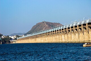
Vijayawada, formerly known as Bezawada, is the second largest city in the Indian state of Andhra Pradesh. It is located on the banks of the Krishna River surrounded by the hills of the Eastern Ghats, known as the Indrakeeladri Hills. The city is home to the important Hindu shrine of Kanaka Durga Temple. It geographically lies on the center spot of Andhra Pradesh. The city has been described as the commercial, political, cultural and educational capital of Andhra Pradesh. It is the administrative headquarters of NTR district. The Prakasam Barrage across the Krishna River connects the NTR and Guntur districts.

<span class="mw-page-title-main">Gannavaram, Vijayawada</span> Suburb in Krishna, Andhra Pradesh, India

Gannavaram is a suburb of Vijayawada in Krishna district of the Indian state of Andhra Pradesh. It is also the mandal headquarters of Gannavaram mandal which is administered under Gudivada revenue division. It is a major suburb of Vijayawada in the North East side.Vijayawada International Airport, Medha IT Park, IT companies like HCL Tech and TechMahindra are located here.

<span class="mw-page-title-main">Araku Valley</span> Hill Station in Andhra Pradesh, India

Araku Valley is a hill station in Alluri Sitharama Raju district in the Indian state of Andhra Pradesh, lying 111 km west of Visakhapatnam city. It is a valley in the Eastern Ghats inhabited by different tribes, mainly Araku Tribes.

<span class="mw-page-title-main">Gajuwaka</span> Neighbourhood in Andhra Pradesh, India

Gajuwaka is a major residential area of Visakhapatnam City, India. This neighborhood of Visakhapatnam is considered the biggest shopping district in Andhra Pradesh by revenue. Though conceived as a residential locality, it is now one of the principal shopping districts of the city. The Gajuwaka area of Visakhapatnam has the highest per capita income in Andhra Pradesh.

<span class="mw-page-title-main">Andhra Pradesh State Road Transport Corporation</span> Indian state bus operator

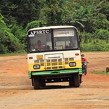
Andhra Pradesh State Road Transport Corporation, officially Andhra Pradesh Raastra Roadu Ravaana Samstha, is the state-owned road transport corporation in the Indian state of Andhra Pradesh. Its headquarters is located at NTR Administrative Block of RTC House in Pandit Nehru bus station of Vijayawada. Many other Indian metro towns in Telangana, Tamil Nadu, Karnataka, Odisha, Yanam, Kerala, Maharashtra and Chhattisgarh are also linked with the APSRTC services.

Pedagantyada is a neighbourhood in the city of Visakhapatnam, India. It is one of the 46 mandals in Visakhapatnam District. It is under the administration of Visakhapatnam revenue division and the headquarters is located at Pedagantyada beside Gajuwaka. The Mandal is bounded by Mulagada and Gajuwaka mandals. It is a major Suburb in Visakhapatnam and got merged in Greater Visakhapatnam Municipal Corporation in 2005. Organisations like Visakhapatnam Steel Plant, and Gangavaram Port are located in this area.

<span class="mw-page-title-main">Pendurthi</span> Neighbourhood in Visakhapatnam, Andhra Pradesh, India

Pendurthi is a neighbourhood in the city of Visakhapatnam, India. The neighbourhood is considered as the major residential and commercial area in the city. It is located within the jurisdiction of the Greater Visakhapatnam Municipal Corporation, which is responsible for the civic amenities in Pendurthi. It is located on the west fringe of Visakhapatnam city. Pendurthi is one of the peaceful neighborhoods of Western Vizag. The pincode of Pendurthi is 531173.

Chilakaluripet is a city in Palnadu district of the Indian state of Andhra Pradesh. It is the Mandal headquarters of Chilakaluripet Mandal in Narasaraopet Revenue Division.

<span class="mw-page-title-main">Economy of Andhra Pradesh</span>

The economy of the Indian state of Andhra Pradesh is primarily dependent on agriculture, which directly and indirectly employs 62% of the population. GSDP as per the first revised estimate, for the year 2023-24 is ₹15,40,000 crore.The state is ranked 1st in the country for the year 2021-22 in terms of the Gross State Domestic Product (GSDP) growth at constant prices with growth rate of 11.43%. The state GSDP is expected to grow at a rate of 17% for the year 2023-24.

<span class="mw-page-title-main">Visakhapatnam Bus Rapid Transit System</span>

Visakhapatnam BRTS :-The implementation of the bus rapid transit system has been taken up as a high-capacity public transport system in Visakhapatnam keeping in view the projected multi-fold increase in traffic and constraints of road capacity. A Bus Rapid Transit System (BRTS) was approved for the city under the Jawaharlal Nehru National Urban Renewal Mission. This project was started in 2008 and most of the route has been constructed except for a 2km stretch near Simhachalam. The delay is due to issues in land acquisition from railways, defence and private parties.

<span class="mw-page-title-main">Madhurawada</span> Neighbourhood in Visakhapatnam, Andhra Pradesh, India

Madhurawada is a major business and residential area of Visakhapatnam in the state of Andhra Pradesh. It is located on the Visakhapatnam-Vizianagaram stretch of National Highway 16 around 16 km from the city center of Visakhapatnam.

GMR Visakhapatnam International Airport is an international airport and a greenfield airport under construction at Bhogapuram in Vizianagaram district, about 40 kilometres (25 mi) north-east of Visakhapatnam.

<span class="mw-page-title-main">Transport in Eluru</span>

There are various modes of transportation available in Eluru, a city in the Indian state of Andhra Pradesh, and its region. It includes auto rickshaws, bicycles to mass transit systems – such as buses and trains. The city was once famed for its traffic problems with the railway gates at Vatluru, Venkatraopet, Powerpet, Old bus stand and Eastern Locks areas. When the National Highway passed through the city, the traffic hurried to pass over the railway gates in the city and outskirts, which makes traffic worse.

<span class="mw-page-title-main">Transport in Vijayawada</span>

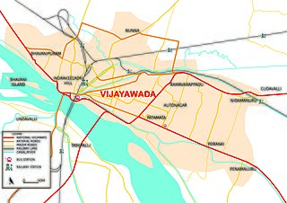
Transport in Vijayawada is the network of roads, railways, rapid transit system in the second largest city of Andhra Pradesh. The city of Vijayawada also serves as the central hub of transport and logistics within the state.

Anakapalli mandal is one of the mandals in located in Anakapalli district of the state of Andhra Pradesh, India. It is administered under Anakapalli revenue division and its headquarters are located at Anakapalli. It is bounded by Kasimkota Mandal towards west, Munagapaka Mandal towards South, Paravada Mandal towards East, Achutapuram Mandal towards South.

Transport in Visakhapatnam is the network of roads, railways, rapid transit system in the largest city of Andhra Pradesh. The city of Visakhapatnam also serves as the central hub of transport and logistics on the East coast of India and hence it is called as City Of Destiny.

<span class="mw-page-title-main">Transport in Nellore</span>

There are various modes of transportation available in Nellore and its region. It includes auto rickshaws, bicycles to mass transit systems - such as buses, trains and ships.

<span class="mw-page-title-main">Transport in Vizianagaram</span>

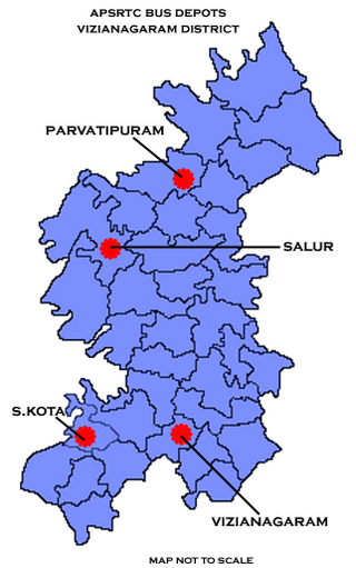
There are various modes of transportation available in Vizianagaram and its Neighbourhoods. It includes auto rickshaws, bicycles to mass transit systems - such as buses, trains and flights.

References

  1. "Upgraded Gunadala rail station by March". Deccan Chronicle. Vijayawada. 19 June 2013. Archived from the original on 4 December 2014. Retrieved 16 January 2016.
  2. "Competition shakes up Visakhapatnam port - Livemint". www.livemint.com. Retrieved 17 April 2017.
  3. 1 2 3 4 "Economic Development Board Andhra Pradesh - Infrastructure". apedb.gov.in. Retrieved 23 April 2017.
  4. ":: APRDC ::". aprdc.ap.gov.in. Retrieved 17 April 2017.
  5. "Roads and Buildings Department". Roads and Buildins Department, Government of Andhra Pradesh. Retrieved 17 April 2017.
  6. "List of National Highways Passing through A.P. State". Roads and Buildings Department. Government of Andhra Pradesh. Archived from the original on 28 March 2016. Retrieved 22 February 2016.
  7. "National Highways". Roads and Buildings Department - Government of Andhra Pradesh. Archived from the original on 28 March 2016. Retrieved 17 April 2017.
  8. "Golden Quadrilateral project". Roadtraffic Technology. Retrieved 14 June 2014.
  9. "Goel wants to put Vizag Railway zone on track". The New Indian Express. Retrieved 4 January 2018.
  10. "Brief of Roads" . Retrieved 25 April 2017.
  11. "Details of Roads in each ULB of Andhra Pradesh". Municipal Administration and Urban Development. Archived from the original on 1 August 2016. Retrieved 17 April 2017.
  12. "Andhra Pradesh Transport department". apsrtc. Archived from the original on 15 March 2015. Retrieved 13 June 2014.
  13. "Naidu to open RTC block today". The Hans India. Retrieved 18 April 2017.
  14. "Vijayawada bus station to be RTC headquarters". The Hans India. Retrieved 18 April 2017.
  15. "RTA officials book 29 cases against private buses". The Hans India. Retrieved 18 April 2017.
  16. Correspondent, Special. "She autos roll out in style in city". The Hindu. Retrieved 18 April 2017.
  17. "Not much impact on first day of lorry strike in Andhra Pradesh". The New Indian Express. Retrieved 18 April 2017.
  18. "ANL Parcel service".
  19. "Statewise Length of Railway Lines and Survey For New Railway Lines". pib.nic.in. Retrieved 4 January 2018.
  20. "Rail-Key Highlights".
  21. "Bullet Train Corridors".
  22. "Diamond Quadrilateral". Archived from the original on 12 June 2017.
  23. "State-wise Route Kilometerage". South Central Railway. Archived from the original on 6 February 2011. Retrieved 23 April 2017.
  24. "South Western railway - divisions". South Western railway. Retrieved 24 April 2023.
  25. "East coast railway divisions". East coast railway. Retrieved 24 April 2023.
  26. "Statement showing category-wise No.of stations" (PDF). South Central Railway. Retrieved 23 April 2017.
  27. "Vizag billed the cleanest rail station". The Hindu. 18 May 2017. ISSN   0971-751X . Retrieved 4 January 2018.
  28. BHATTACHARJEE, SUMIT. "Hidden 100 - 58 tunnels. 84 bridges. Welcome to Araku Valley". The Hindu. Retrieved 23 April 2017.
  29. "Vizag Airport Info". Hindubuisnessline. Retrieved 9 June 2014.
  30. "Airports" (PDF). AP State Portal. Archived from the original (PDF) on 23 September 2015. Retrieved 23 June 2014.
  31. "Airports Highlights".
  32. T, Appala Naidu. "AP gears up to implement fishing ban". The Hindu. Retrieved 23 April 2017.
  33. "State-wise traffid handled at non-major ports" (PDF). Indian Ports Association. Retrieved 23 April 2017.
  34. "Inland Waterways".
  35. "Inland waterway cargo traffic in Andhra to start in December".