Eluru

Last updated

Eluru
Helapuri
City
District Collectorate of West Godavari (May 2019) 3.jpg
Eluru Railway Station Main Entrance.jpg
EluruBuddhaParkevening.jpg
A view of Police quarters from Hotel Grand Arya.jpg
Clockwise from top: District Collector Office, Gautam Buddha Park, Police Quarters, and Eluru railway station
India Andhra Pradesh location map (current).svg
Red pog.svg
Eluru
Coordinates: 16°42′42″N81°06′11″E / 16.71167°N 81.10306°E / 16.71167; 81.10306
CountryFlag of India.svg  India
State Andhra Pradesh
District Eluru
Founded2nd century
Incorporated (town)1866
Incorporated (city)9 April 2005
Government
  Type Mayor–council
  Body Eluru Municipal Corporation, EUDA
   M.P Kotagiri Sridhar (YSRCP)
   M.L.A Alla Kali Krishna Srinivas (YSRCP)
Area
[1]
  City11.52 km2 (4.45 sq mi)
  Urban
154 km2 (59 sq mi)
  Metro
[2]
3,328.99 km2 (1,285.33 sq mi)
Elevation
22 m (72 ft)
Population
 (2011)
  City214,414 [3]
  Rank 12th (in state)
   Metro
2,760,160 [2]
Demonym(s) Elurian, Elurite, Helapuree
Languages
  Official Telugu
Time zone UTC+5:30 (IST)
PIN
534***
Telephone code +91–08812
Vehicle registration AP-39
Website eluru.cdma.ap.gov.in/en

Eluru is a city and the district headquarters of Eluru district in the Indian state of Andhra Pradesh. It is one of the 14 municipal corporations in the state and the mandal headquarters of Eluru mandal in the Eluru revenue division. The city is on the Tammileru river. The city is well known for its wool-pile carpets and hand woven products. As of 2011 Census of India, the city had a population of 214,414. Its history dates back to the second century CE.

Contents

Etymology

It was a part of the Vengi Kingdom. [4] During the rule of the Buddhist kingdom of Vengi, it was the capital city and was known as 'Helapuri'. [5] It was also known as 'Ellore'. [6] To distinguish with Vellore, which was having same pronunciation during Nizam rule, Ellore was referred as Uppu Ellore (i.e. Salt Ellore), while the former one was referred as Ra Vellore or Raya Vellore. [7]

History

Map of Andhra Pradesh prior to Independence Andhra Pradesh deu.png
Map of Andhra Pradesh prior to Independence
There were 25 inscriptions of Vengi Chalukyas found on these pillars of Mandapam at Kotadibba, (Eluru Fort Land) Inscriptions of Vengi Chalukyas found at Kotadibba (Eluru Fort).jpg
There were 25 inscriptions of Vengi Chalukyas found on these pillars of Mandapam at Kotadibba, (Eluru Fort Land)

Ancient history

The history of Eluru dates back to the second century CE and has great prominence in the history of Andhra. Vengi near Eluru was the capital of Andhra from the second century to the twelfth century, ruled by Salankayanas, Vishnukudinas, and Eastern Chalukyas. Vengi was the capital city of Andhradesa for more years than any other city in Andhra Pradesh. Eluru was part of the Buddhist kingdom of Vengi.

Salankayanas

Salankayana ruled from the third century CE to the fifth century CE. [8] They were known as Salankayana after the Gotra name and were the feudatories of Ikshvakus. They ruled near the Vengi area, with Vengi (Eluru) as the capital. Salankayana is another of the Phantom kingdoms of Andhra for Indologists. Their date is fixed based on Samudra Gupta inscription mention of Hastivarman of Vengi. [9]

Vishnukundina

Eluru was a major city of the Vishnukundinas. [10] Vishnukundin reign might be fixed between the end of the Salankayana and the rise of the Eastern Chalukyan power in 624 AD. [11] In the late fifth century, the Salankayanas were conquered by Madhavarma II of the Vishnukundinas. During the reign of Madhava Varma the Great, they became independent and conquered coastal Andhra from the Salankayanas and might have shifted their capital to a place in coastal Andhra. [12]

Eastern Chalukyas

Eastern Chalukyas, or Chalukyas of Vengi, were a dynasty of South India whose kingdom was in the present day Andhra Pradesh. Their capital was Vengi near Eluru and their dynasty lasted around 500 years from the seventh century until c. 1130 C.E., when the Vengi kingdom merged with the Chola empire. [13] The Vengi kingdom continued to be ruled by the Eastern Chalukyas (Eastern Chalukyan kings) under the protection of the Chola empire until 1189 C.E., when the kingdom succumbed to the Hoysalas and the Yadavas. They had their capital originally at Vengi, now Pedavegi, near Eluru of the West Godavari district and was later changed to Rajamahendravaram (Rajahmundry).

13th century to 16th century

Eluru was captured by the Kakatiyas and then became a part of the Kalinga Empire until 1471. Later, it fell into the hands of the Gajapatis. In 1515, Srikrishnadevaraya captured it. After the fall of the Vijayanagara Kingdom, it was taken by the Sultan of Golkonda, Kutub Shah. Mohammedans built the fort at Eluru from the ruins of Vengi. [14]

Modern history

Salabat Jung, the fourth Nizam of Hyderabad, granted, in 1753, the region including Eluru to the French East India Company. But, the French were forced to transfer it to the British within a few years. During British rule, Eluru was a military station and the capital of the Northern Circars, a division of the Madras Presidency. [15] [16] In the Madras Presidency, the District of Rajahmundry was created in 1823. [17] It was reorganized in 1859 and was bifurcated into Godavari and Machilipatnam districts. Eluru was a part of Machilipatnam district after the division of the Northern Circars. In 1859, it was included in the Godavari district; later, it was made a part of the Krishna district. During British rule, Rajahmundry was the headquarters of the Godavari district, which was further bifurcated into East Godavari and West Godavari districts in 1925. When the Godavari district was divided, Eluru became the headquarters of West Godavari. [18]

In early December 2020, a mystery illness in Eluru killed one person and more than 400 were hospitalised. [19] [20] Preliminary results indicate the cause to be water and milk contaminated by lead and nickel. [21]

Geography

Tammileru river at Ashok nagar during floods in 2020 Tammileru river diverging near Eluru during Floods 2020.jpg
Tammileru river at Ashok nagar during floods in 2020

Eluru is at 16°42′42″N81°06′11″E / 16.71167°N 81.10306°E / 16.71167; 81.10306 and has an average elevation of 22 m (72 ft). It lies on the Eastern coastal plains. [22] It is about halfway between the Krishna and Godavari rivers and about 50 kilometers inland from the Bay of Bengal. The Tammileru river and the Krishna and Godavari canals pass through the city, before the river. The Eluru canal from Krishna empties into Kolleru Lake near the city. [18]

Climate

Eluru experiences hot and humid climate due to its proximity to the shore of Bay of Bengal. It has an average annual temperature of 28.2 °C (82.8 °F). May is the hottest and December is the coolest month of the year. Temperature crosses 40 °C (104 °F) in summer. [23] July receives most precipitation and annually the city receives an average rainfall of 992 mm (39.1 in). [24]

Climate data for Eluru, Andhra Pradesh
MonthJanFebMarAprMayJunJulAugSepOctNovDecYear
Mean daily maximum °C (°F)29.1
(84.4)
31.7
(89.1)
34.5
(94.1)
36.7
(98.1)
38.6
(101.5)
36.9
(98.4)
32.4
(90.3)
32.0
(89.6)
32.2
(90.0)
31.4
(88.5)
29.8
(85.6)
28.8
(83.8)
32.8
(91.1)
Mean daily minimum °C (°F)18.9
(66.0)
20.3
(68.5)
22.6
(72.7)
25.8
(78.4)
27.9
(82.2)
27.2
(81.0)
25.4
(77.7)
25.3
(77.5)
25.3
(77.5)
24.3
(75.7)
21.3
(70.3)
18.8
(65.8)
23.6
(74.4)
Average rainfall mm (inches)3
(0.1)
6
(0.2)
6
(0.2)
14
(0.6)
40
(1.6)
123
(4.8)
229
(9.0)
186
(7.3)
170
(6.7)
166
(6.5)
40
(1.6)
9
(0.4)
992
(39)
Source: en.climate-data.org

Demographics

Religions in Eluru [25]
ReligionPercent
Hindu
89.51%
Muslim
7.02%
Christians
2.74%
Others†
0.72%
Includes Sikhs, Jains

As of 2011 census of India, Eluru Municipal Corporation had a population of 214,414 of which 105,707 were male and 108,707 female, [3] whilst Eluru urban agglomeration had a population of 250,693. [26] The estimated city population during 2015–16, period was 350,000. [27] [28]

Governance

A view of Police Quarters from Hotel Grand Arya A view of Police quarters from Hotel Grand Arya.jpg
A view of Police Quarters from Hotel Grand Arya

Civic administration

Eluru Municipal Corporation is the civic body of Eluru. It was first constituted as a municipality in 1866. [29] It was upgraded to Municipal Corporation on 9 April 2005 from selection grade municipality. [5] It is spread over an area of 14.50 km2 (5.60 sq mi) with 50 wards. [1]

The present Municipal Commissioner of the city is Y.Sai Sreekanth and the Mayor is Shaik Noorjahan. [30] In 2015, as per the 'Swachh Bharat Abhiyan' of the Ministry of Urban Development, Eluru Municipal Corporation was ranked 249th in the country. [31]

Eluru urban agglomeration is spread over an area of 23.85 km2 (9.21 sq mi) and its constituents include Eluru municipal corporation, census towns of Sanivarapupeta, Satrampadu, Gavaravaram, Tangellamudi, and partly out growths of Komadavole, Eluru (rural) villages. [32] [33] :54

Law and order in Eluru is maintained with the help of eight police stations, which includes one woman and one traffic police station. These are under the jurisdiction of the 'Additional Judicial First Class Magistrate'. [34]


Politics

Eluru (Assembly constituency) is one of the constituencies for Andhra Pradesh Legislative Assembly. Alla Nani is the present MLA of the constituency from YSR Congress Party. [35] The constituency falls under Eluru (Lok Sabha constituency) which was won by Kotagiri Sridhar of the same party. [36] [37] The city is going to be the head office for the Jana Sena Party. [38]

Economy

CMR Central: A Multiplex mall in the city CMR Multiplex in Eluru (01).jpg
CMR Central: A Multiplex mall in the city

Since the 17th century, Eluru was known for rug weaving, derived from weavers of Iranian descendants. [6] R.R.Pet, Powerpet, Eluru 1-Town area are the commercial centres. [39] Tangellamudi, Sanivarapupeta and Lakshavarapupeta areas of the city are known for the wool pile carpet industry. The eco-friendly carpets are exported to countries like the United States, Australia, Germany and the United Kingdom. [40] [41]

Government allotted 1.416 km2 (0.547 sq mi) of land near Vatluru and Bhogapuram for a light combat aircraft manufacturing facility [42] which is estimated to cost about 2,135 billion (US$27 billion). [43]

Culture

An antique museum is being set up in the city, that will preserve prehistoric tools, idols, and elements found in the archaeological excavations near the city. [44] [45] [46]

Notable people

Notable people from Eluru include Kommareddi Suryanarayana, a Rajya Sabha and Lok Sabha member in Indian Parliament and Indian freedom activist; Murali Mohan, a member of parliament and Telugu film actor, producer and business executive; Duvvuri Subbarao, an Economist and the 22nd Governor of the Reserve Bank of India; Justice Muhammad Shahabuddin, Judge Federal Court of Pakistan and Governor East Pakistan; Kurma Venkata Reddy Naidu, a lawyer, professor, Justice Party leader, Governor and Chief Minister of Madras Presidency; Chodagam Ammanna Raja, Indian freedom movement activist and Rajya Sabha member; Mothey Vedakumari, parliamentarian and singer; V. S. Ramadevi, the first woman to become Chief Election Commissioner of India; Pawan Kumar, former cricketer for Andhra and Hyderabad.

People from film industry are; L. V. Prasad, film producer, actor, director, cinematographer and businessman; Pasupuleti Kannamba, actress, playback singer and film producer of Telugu cinema; Vijaya Bapineedu, magazine editor, film screenwriter and director; V. N. Aditya, film director and screenwriter; Sekhar Kammula, film director, screenwriter and producer; Silk Smitha, film actress; Naga Shaurya, film actor; Shanmukha Srinivas, film actor and an accomplished Kuchipudi dancer. Arvind Krishna is the chairman and CEO of IBM.

Cityscape

View of Buddha Statue EluruBuddhaParkevening.jpg
View of Buddha Statue

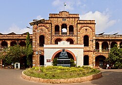
Eluru Buddha Park is in the city and is notable for its 74 ft (23 m) Buddha statue in the Abhaya posture, in the heart of Gaja Vallivari Cheruvu tank which was used as drinking water source for elephants in the Ancient Era. [47]

Kolleru Lake is a very large (30,855 hectares [100 sq mi] to 90,100 hectares [300 sq mi]) but shallow fresh-water lake, about 15 km from the city. The lake is known for attracting migratory birds from Northern Europe and Northern Asia during the months of October–March and is designated as the Kolleru Bird Sanctuary. As of 2018, the water level has been low in recent years. [48] [49] [50]

The "Holy Land" of Israel has been replicated on the premises of Fr. Silvio Pasquali Memorial Convent at Duggirala on the city outskirts. [51]

Neighbourhoods

The city has neighbourhoods including Ramachandrarao Pet (R.R. Pet), Narasimharao Pet (N.R. Pet), [56] Pathebada, [57] One-Town (1-Town), Powerpet, Satrampadu, Sanivarapupeta, Vatluru.

Transport

National Highway 16 and Eluru canal near Eluru Aerial view of National Highway 16 near Denduluru.jpg
National Highway 16 and Eluru canal near Eluru

Public transport systems in the city and for long-distance travel include government run APSRTC buses, privately operated auto rickshaws, cabs, mini-buses etc. Every day, around 4000 auto rickshaws flee on city roads. [58] National Highway 16, a part of Asian Highway 45 and Golden Quadrilateral highway network, bypasses the city and connects Kolkata with Chennai. [59] [60] GNT Road, Mini-Bypass Road, Canal Road and Sanivarapupeta Road are the major internal arterial roads. The city has a total road length of 227.09 km (141.11 mi). [61]

NH216A , is a Spur road of NH16 starts from Eluru Bypass near vatluru connecting Gundugolanu , Bhimadole , Pulla , Kaikaram , Chebrolu , Unguturu , Tadepalligudem , Duvva , Tanuku , Peravali , Khanadavalli , Siddantham, Ravulapalem , Vemagiri , Kadiyapulanka and ends at Rajahmundry .

APSRTC operates its bus services from Eluru Old and Eluru New bus stations [62] [63] to parts of the State Vijayawada, Rajahmundry , Guntur, Nellore, Visakhapatnam , Tirupati , Srikakulam , Tekkali Palasa , Tanuku , Annavaram , Tadepalligudem , Kovvur , Kakinada , Tuni , vizianagaram , Salur , Parvathipuram , Palakonda Kaikaluru , Bhimavaram , Palakollu , Narsapuram , Gudivada , Machilipatnam , Jangareddigudem , Nuzvid , Hanuman junction , Srisailam , Narsaraopeta , Ongole , and to other states (mostly Hyderabad , Khammam , Bhadrachalam , Aswaraopeta , Banglore , Gangavathi , Raichuru). [64] State Highway 43 and State Highway 44 connect Eluru with Sathupalli and Jangareddygudem respectively. [65]

Eluru railway station is classified as an 'A–category station' in the Vijayawada railway division of South Coast Railway zone. [66] [67] Apart from the main station, other stations that serve the city include Powerpet, Denduluru and Vatluru. All these stations are on the Howrah-Chennai main line. Eluru is one of the top 100 booking stations of Indian railways. Nearest Airport to Eluru city is Gannavaram Airport which is 35 km from Eluru City.[ citation needed ]

Indian National Waterway 4 (NW-4) is under development. It runs along the Northern Circars through Kakinada, Rajamahendravaram, Eluru, Commanur, Buckingham Canal, and part of the Krishna and Godavari rivers in South India. [68]

Sports

ASR Stadium ASR Stadium near railway station.jpg
ASR Stadium

ASR Stadium was named after Alluri Sitarama Raju

Cricket and soccer are the most popular sports in the city. Presently, the city has four stadium out of which Indoor Stadium and ASR Stadium hosted for Ranji Trophy in 1977. Other popular stadiums are Helapuri grounds, C.R. Reddy Cricket Stadium.

Alluri Sitarama Raju Stadium

ASR stadium is located at 16°43′8″N81°6′58″E / 16.71889°N 81.11611°E / 16.71889; 81.11611 . [69] [70] It had earlier hosted a Ranji Trophy match, handball, football and hockey tournaments. [70] The ground first held a single first-class match in 1976 when Andhra Pradesh played Hyderabad in the 1976/77 Ranji Trophy, [71] which ended in a draw. [72] It held Finals of Football League of West Godavari Matches in 2016. Current DSDO is Syed Azeez. [73]

Education

Eluru plays a major role in education for urban and rural students from nearby villages. [74] It has an average literacy rate of 83.90% with, according to the 2011 census, a total number of 155,894 who are literate. This includes, 80,434 men (88.13%) and 75,460 women (79.82%). [75]

Primary and secondary school education is provided by government, aided, and private schools, under the School Education Department of Andhra Pradesh. [76] According to the school information report for the academic year 2016–17, the urban area has around 160 schools. These include government, residential, private, municipal, and other types of schools. There are more than 100 private schools and 49 municipal schools. [77] There are more than 30,000 students in these schools. [78]

Instruction is in English, Urdu, and Telugu.

Sri Chintalapati Varaprasada Murthy Raju was the founder of Chintalpati Satyavathi Devi College (St. Therisa College) and three high schools in the name of Indian freedom fighters: Kasturiba Girls High School, Balagangadhar Tilak Oriental for Sanskrit, Duggirala Gopal Krishnayya. Moulana Abdul Kalam Azad High School (the only school with Urdu as medium of instruction in the district). [74] The Central Board of Secondary Education, Secondary School Certificate, or the Indian Certificate of Secondary Education are the types of syllabus followed by schools.

The government plans to set up Municipal Corporation Junior College in the city. [79] Eluru city has ASRAM Medical college, St Joseph Dental College, Sir C.R. Reddy Degree College, Sir C.R. Reddy College of Engineering, [80] Eluru College of Engineering and Technology, Ramachandra College of Engineering, Nova College, Helapuri Engineering College are Engineering colleges present in and around Eluru.

Sir C.R. Reddy College, situated in Eluru, has had many famous celebrity graduates. A few of them are Ghattamaneni Krishna, an actor in Telugu cinema and also Member of Parliament, Kota Srinivasa Rao, also an actor in Telugu Cinema and Member of the Legislative Assembly, D Subbarao, the former Governor of the Reserve Bank of India, etc.

Research

The city is home to the Indian Institute of Oil Palm Research. [81]

See also

Related Research Articles

<span class="mw-page-title-main">East Godavari district</span> District of Andhra Pradesh in India

East Godavari is a district in the Coastal Andhra region of Andhra Pradesh, India. Its district headquarters is at Rajamahendravaram.

<span class="mw-page-title-main">Coastal Andhra</span> Geographic region of Andhra Pradesh, India

Coastal Andhra or Kosta Andhra is a geographic region in the States and union territories of India of Andhra Pradesh. Vijayawada is the largest city in this region. Region share borders with Uttarandhra, Rayalaseema and Telangana. It was part of Madras State before 1953 and Andhra State from 1953 to 1956. According to the 2011 census, it has an area of 91,915 square kilometres (35,489 sq mi) which is 57.99% of the total state area and a population of 34,193,868 which is 69.20% of Andhra Pradesh state population. This area includes the coastal districts of Andhra Pradesh on the Circar Coast between the Eastern Ghats and the Bay of Bengal, from the northern border with Odisha to Rayalaseema in the south.

<span class="mw-page-title-main">Rajahmundry</span> District Headquarter in Andhra Pradesh, India

Rajahmundry, officially Rajamahendravaram, is a city in the Indian state of Andhra Pradesh and district headquarters of East Godavari district. It is the seventh most populated city in the state. During British rule, the district of Rajahmundry was created in the Madras Presidency in 1823. It was reorganised in 1859 and bifurcated into the Godavari and Krishna districts. Rajahmundry was the headquarters of Godavari district, which was further bifurcated into East Godavari and West Godavari districts in 1925. It is administered under Rajahmundry revenue division of the East Godavari district. The city is known for its floriculture, history, culture, agriculture, economy, tourism, and its heritage. It is known as the "Cultural Capital of Andhra Pradesh".

<span class="mw-page-title-main">West Godavari district</span> District of Andhra Pradesh in India

The West Godavari district is a coastal district in the Indian state of Andhra Pradesh with an administrative headquarters in Bhimavaram. As of the 2011 Census of India, the district has an area of 2,178 km2 (841 sq mi) and a population of 1,779,935. It is bounded by the Krishna district and Bay of Bengal to the south, East Godavari district to the east, and Eluru district, Kolleru Lake and Upputeru Drain to the northwest.

Kakinada is the sixth largest city of the Indian state of Andhra Pradesh and serves as the district headquarters of the Kakinada District. It lies on the coast of the Bay of Bengal. J.N.T.U. College of Engineering Kakinada, established in 1946, is the oldest and popular Government college in the state of Andhra Pradesh. The First Polytechnic college of Andhra Pradesh, Andhra Polytechnic was established here in 1946. It was also the origin point of Buckingham Canal where goods used to be transported by boats during the British rule. It was once home for Asia's largest sea port. Many people from the city migrated from this sea port to countries like Burma, Mauritius, Fiji and various southeast Asian countries to work there as workers where they were called as Coringas.

<span class="mw-page-title-main">Kovvur</span> Town in Andhra Pradesh, India

Kovvur is a town in the East Godavari district of the Indian state of Andhra Pradesh. It is a municipality and the mandal headquarters of Kovvur mandal in Kovvur revenue division.

<span class="mw-page-title-main">Bhimavaram</span> City in Andhra Pradesh, India

Bhimavaram is a city and headquarters of West Godavari district of the Andhra Pradesh state of India. It is the administrative headquarters of Bhimavaram mandal in Bhimavaram revenue division. It is a part of Eluru Urban Development Authority. As of 2011 census, it is the most populous urban area in the district with a population of 163,875. It is one of the major pilgrimage centers in the state, which is home to Somaramam, one of the five great Pancharama Kshetras.

<span class="mw-page-title-main">Palakollu</span> City in Andhra Pradesh, India

Palakollu is a city and the administrative headquarters of Palakollu Mandal in Narasapuram revenue division in West Godavari district of the Indian state of Andhra Pradesh. Palakollu is situated in Coastal Andhra region of the state. It occupies 4.685 square kilometres (1.809 sq mi). As of 2011 census, it had a population of about 61,284 and a Metro population of about 81,199. Palakollu Municipality merged five Grama panchayats of Seven village's on 7 January 2020. The Seven Villages' had a population of 42,932 as of 2011 Census. It around occupies 20.08 square kilometres (7.75 sq mi) and after merged palakollu municipality, It around occupies 24.68 square kilometres (9.53 sq mi) with 35 election wards it is total population of 1,04,216 and making it the third most populous urban area in West Godavari District in Andhra Pradesh. It is a part of Eluru Urban Development Authority.

Vengi or Venginadu is an Indian region in modern-day Andhra Pradesh spread over the Godavari and Krishna river deltas. The capital city of Vengi is located at Pedavegi near Eluru. Vengi was the most prominent city in Ancient Andhra for nearly seven centuries. Vengi served as the capital for Andhra dynasty like Salankayanas This region was part of Ashoka's Mauryan Empire in the mid-3rd century BCE. After the Mauryan Empire collapsed in 185 BC, the region was dominated by the Satavahanas, who were succeeded in Vengi by the Andhra Ikshvakus. Around 300 CE, the Andhra Ikshvakus were replaced by the Salankayanas. In the late 5th century, the Salankayanas were annexed by the Vishnukundinas.

<span class="mw-page-title-main">Pithapuram</span> City in Andhra Pradesh, India

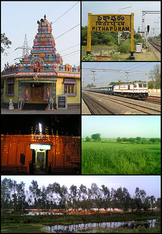
Pithapuram or Pitapuram is a city and a municipality in the Kakinada district of Andhra Pradesh, India. The city also forms a part of Godavari Urban Development Authority. Pitapuram is home to one of the eighteen Maha Sakthi Peethas, which are significant shrines and pilgrimage destinations in Shaktism. Sripada Sri Vallabha, a prominent Hindu saint of 14th century born and lived in Pitapuram.

<span class="mw-page-title-main">Jangareddygudem</span> Town in Andhra Pradesh, India

Jangareddygudem (JRG) is a municipality in newly formed Eluru district which is previously in West Godavari district of the Indian state of Andhra Pradesh.

<span class="mw-page-title-main">Samalkota</span> Town in Andhra Pradesh, India

Samarlakota is a town in Kakinada district of the Indian state of Andhra Pradesh. The town forms a part of Godavari Urban Development Authority. It was previously known as Chamarlakota, which dates back to a local kaifiyat that was written in the mid-eighteenth century.

<span class="mw-page-title-main">Hanuman Junction</span> Town in Andhra Pradesh, India

Hanuman Junction is a town which lies between the borders of Krishna and Eluru District of Andhra Pradesh state in India. Hanuman Junction gets its name because it is located in the X-Junction of NH-16 & AH-45.

Rajanagaram is a locality in Rajamahendravaram City. It also forms a part of Godavari Urban Development Authority.

Eluru mandal is one of the 28 mandals in Eluru district of the Indian state of Andhra Pradesh. It is administered under Eluru revenue division and its headquarters are located at Eluru city. The mandal is bounded by Pedapadu mandal, Pedavegi mandal, Denduluru mandal, Bhimadole mandal and it also borders Krishna district.

<span class="mw-page-title-main">Sanivarapupeta</span> Census Town in Andhra Pradesh, India

Sanivarapupeta is a census town in Eluru district of the Indian state of Andhra Pradesh. It is located in Eluru mandal of Eluru revenue division. The town is a constituent of Eluru urban agglomeration.

Komadavole is an out growth of Eluru city in Eluru district of the Indian state of Andhra Pradesh. It is located in Eluru mandal of Eluru revenue division. It is also a constituent of Eluru Urban Agglomeration.

Velagalapalli is a village located in Chintalapudi Mandal of West Godavari District in the state of Andhra Pradesh, India.

<span class="mw-page-title-main">Eluru district</span> District of Andhra Pradesh in India

Eluru district is a district in coastal Andhra Region in the Indian state of Andhra Pradesh. With Eluru as its administrative headquarters, it was proposed on 26 January 2022 to become one of the resultant twenty six districts in the state once a final notification is issued by the government of Andhra Pradesh. It is formed from Eluru revenue division and Jangareddygudem revenue division from West Godavari district and Nuzvid revenue division from Krishna district.

Rajahmundry Circar or Rajahmundry Sarkar was one of the five Northern Circars in the Golconda Sultanate, Deccan subah of Mughal empire and later in the Nizam's dominion of Hyderabad. The Northern Circars were the most prominent ones in the Deccan subah. Eastern Ghats near Pentakota village were considered the northern limit of the Rajahmundry Circar while the southern limit was demarcated by the Godavari river.

References

  1. 1 2 "Municipality Profile | Eluru Municipal Corporation". eluru.cdma.ap.gov.in. Archived from the original on 11 March 2017. Retrieved 2 April 2017.
  2. 1 2 Constitution of Eluru Urban Development Authority (EUDA) with Head Quarters at Eluru (PDF). Amaravati: Government of Andhra Pradesh. 2019. p. 3.
  3. 1 2 "Cities having population 1 lakh and above" (PDF). Census of India 2011. Retrieved 8 September 2019.
  4. Neelameggham, Indra (11 August 2022). Ponniyin Selvan in English - Ponni's Beloved Part I New Floods: 2022 Edition of First translation of Kalki's Tamil work in English done in 1990-94. Indra Neelameggham.
  5. 1 2 Unnisa, Syeda Azeem; Rav, S. Bhupatthi, eds. (2013). Sustainable solid waste management (Online-Ausg. ed.). Toronto: Apple Academic Press. p. 49. ISBN   978-1-926895-24-6 . Retrieved 18 September 2015.
  6. 1 2 Stone, Peter F. (19 November 2013). Oriental Rugs: An Illustrated Lexicon of Motifs, Materials, and Origins. Tuttle Publishing. ISBN   978-1-4629-1184-4 . Retrieved 7 May 2017.
  7. Charles Philip Brown (1852). "English Translations of the Exercises and Documents Printed in the Telugu Reader". C.M. Pereyra, at the Price Current Pres. p. 57.
  8. "Vijayawada set to regain pre-eminence as Andhra Pradesh's capital". The Times of India . 4 September 2014. Archived from the original on 11 November 2020. Retrieved 15 May 2017.
  9. "Controversies in History: Vengi".
  10. "The Sampradaya Sun – Independent Vaisnava News – Feature Stories – May 2015". www.harekrsna.com. Archived from the original on 12 January 2017.
  11. "EASTERN CHALUKYAS". Archived from the original on 17 June 2016. Retrieved 9 October 2016.
  12. "Archeological Survey of India". Archived from the original on 12 January 2017. Retrieved 23 July 2016.
  13. "West Godavari district, irrigated by two mighty rivers, is on the road to agricultural prosperity thanks to various schemes". 3 May 2012. Archived from the original on 23 October 2020. Retrieved 15 May 2017.
  14. Francis, W. (1 January 2002). "Gazetteer of South India". Mittal Publications via Google Books.
  15. Chisholm, Hugh, ed. (1911). "Ellore"  . Encyclopædia Britannica . Vol. 9 (11th ed.). Cambridge University Press. p. 294.
  16. Hunter, Sir William Wilson (1885). The Imperial Gazetteer of India. Trübner & Company. pp. 351–352.
  17. Bhaskar, B. v s (8 June 2014). "Nyapathi Subbarao carved an identity for Telugus". The Hindu. Archived from the original on 6 April 2021 via www.thehindu.com.
  18. 1 2 ":: Eluru Municipal Corporation". Archived from the original on 1 November 2018. Retrieved 20 August 2015.
  19. Dash, Jatindra; Varadhan, Sudarshan (7 December 2020). "Hundreds rushed to hospital in India, one dead from unknown illness". Reuters. Archived from the original on 6 April 2021. Retrieved 7 December 2020 via uk.reuters.com.
  20. "Mystery illness lands over 300 people in the hospital in southern India". www.cbsnews.com. Archived from the original on 17 February 2021. Retrieved 7 December 2020.
  21. "Heavy metal content in water caused mysterious disease in AP". The Siasat Daily. 8 December 2020. Archived from the original on 17 February 2021. Retrieved 8 December 2020.
  22. Sr.Bimcy; Sr.Sisily; Charlotte. Bibliographic information. Scholar Publishing House. pp. 20–21. ISBN   978-8171725168 . Retrieved 28 August 2015.
  23. "Severe heat continues to sizzle West Godavari". The Hans India. 27 April 2017. Archived from the original on 29 October 2020. Retrieved 8 May 2017.
  24. "Climate: Eluru – Climate graph, Temperature graph, Climate table – Climate-Data.org". en.climate-data.org. Retrieved 11 May 2016.
  25. "Eluru City Population Census 2011 – Andhra Pradesh".
  26. "Urban Agglomerations/Cities having population 1 lakh and above" (PDF). Census of India 2011. Retrieved 8 September 2019.
  27. "Traffic woes grip Eluru". The Hans India. 20 September 2016. Archived from the original on 20 October 2020.
  28. "Traffic gridlock hits Eluru hard". The Hans India. 11 October 2015. Archived from the original on 27 October 2020.
  29. "Municipalities, Municipal Corporations & UDAs" (PDF). Directorate of Town and Country Planning. Government of Andhra Pradesh. Archived from the original (PDF) on 28 January 2016. Retrieved 29 January 2016.
  30. "Contact Details of Commissioners and Mayors of Amrut Cities" (PDF). Atal Mission for Rejuvenation and Urban Transformation. Government of India. Retrieved 28 March 2016.
  31. Kumar, S Sandeep (10 August 2015). "Small towns fare better in Swachh Bharat rankings". The Hindu. Archived from the original on 16 June 2020. Retrieved 30 March 2016.
  32. "West Godavari District Mandals" (PDF). Census of India. p. 439. Retrieved 19 January 2015.
  33. "District Census Handbook – West Godavari" (PDF). Census of India. pp. 22–23, 54. Retrieved 18 January 2015.
  34. "Territorial Jurisdiction of Criminal Courts". Official Website of District Court of India. Archived from the original on 12 January 2016. Retrieved 12 January 2016.
  35. "MLA". AP State Portal. Archived from the original on 8 October 2014. Retrieved 18 September 2015.
  36. "MP (Lok Sabha)". Government of AP. Archived from the original on 21 November 2016. Retrieved 4 May 2015.
  37. "Delimitation of Parliamentary and Assembly Constituencies Order, 2008" (PDF). Election Commission of India. p. 20,30. Retrieved 11 October 2014.
  38. "Pawan Kalyan to open office in Eluru soon". The New Indian Express. Archived from the original on 24 November 2020.
  39. "Lack of parking lots causes severe traffic snarls". The New Indian Express. Archived from the original on 28 February 2019. Retrieved 13 May 2017.
  40. Nagaraja, G (20 March 2014). "Handmade carpet industry in doldrums". The Hindu. Archived from the original on 25 March 2014. Retrieved 26 November 2015.
  41. Sajnani, Manohar (2001). Encyclopaedia of tourism resources in India. New Delhi: Kalpaz Pub. p. 66. ISBN   978-81-7835-018-9 . Retrieved 26 November 2015.
  42. "Light Combat Aircraft manufacturing facility to come up in Andhra Pradesh". Archived from the original on 9 December 2020. Retrieved 15 May 2017.
  43. "Andhra Pradesh to have first private sector Light Combat Aircraft manufacturing unit". International Business Times . Archived from the original on 13 August 2020. Retrieved 15 May 2017.
  44. Nagaraja, G (16 April 2014). "Antique museum at Eluru soon". The Hindu. Eluru. Archived from the original on 5 June 2014. Retrieved 2 March 2016.
  45. Babu, A. Satish (2008). Tourism development in India: a case study. New Delhi: A.P.H.Pub.Corp. p. 87. ISBN   978-81-313-0346-7 . Retrieved 2 December 2015.
  46. "Museums, forts to get facelift in state". The Hans India. 28 June 2018. Archived from the original on 27 October 2020. Retrieved 24 November 2018.
  47. Nagaraja, G. (4 May 2013). "Gajjalavari Cheruvu set to turn into a Buddhist centre". The Hindu. ISSN   0971-751X . Retrieved 21 May 2019.
  48. "Kolleru Lake | Ramsar Sites Information Service". rsis.ramsar.org. Archived from the original on 6 November 2020.
  49. "Kolleru Lake | lake, India". Encyclopedia Britannica. Archived from the original on 25 January 2021. Retrieved 2 June 2018.
  50. Kumar, S. Sanjay. "Dried up Kolleru Lake leaves Andhra Pradesh villagers high and dry". The New Indian Express. Archived from the original on 9 November 2020. Retrieved 2 June 2018.
  51. "'Holy Land' thrown open to public". 29 January 2014. Archived from the original on 12 January 2017 via The Hindu.
  52. "Call to protect extensive Buddhist heritage in State". The Hindu. 17 May 2019. ISSN   0971-751X . Retrieved 21 May 2019.
  53. "400-yr-old miniature mosque in Eluru city cries for attention". The Times of India. 27 October 2018. Retrieved 21 May 2019.
  54. "Adopted Temples | Temple Info | Sri Venkateswara Swamy Vari Devasthanam". tms.ap.gov.in. Retrieved 21 May 2019.
  55. "CM N Chandrababu Naidu unveils 12.5 feet bronze statue of SV Ranga Rao". The New Indian Express. Retrieved 21 May 2019.
  56. "Heavy rain lashes Eluru". www.thehansindia.com. 26 June 2016. Archived from the original on 20 October 2020.
  57. Special Correspondent. "ACB slueths seize rs.6 crore worth assets from WG dpo's houses". The New Indian Express. Archived from the original on 24 October 2020.
  58. "Buses scarce; Auto drivers fleece commuters". www.thehansindia.com. 8 January 2018. Archived from the original on 29 October 2020. Retrieved 21 May 2019.
  59. "Axe may fall on firm for delay in national highway expansion – Times of India". The Times of India. Archived from the original on 1 October 2020. Retrieved 13 May 2017.
  60. "National Highways in A.P". AP Online Portal. Archived from the original on 10 October 2013. Retrieved 4 August 2014.
  61. "Details of Roads in each ULB of Andhra Pradesh". Municipal Administration and Urban Development Department. Archived from the original on 1 August 2016. Retrieved 27 June 2016.
  62. "Bus Stations in Districts". Andhra Pradesh State Road Transport Corporation. Archived from the original on 22 March 2016. Retrieved 8 March 2016.
  63. "Eluru old bus stand in bad shape". Eluru. 26 May 2006. Archived from the original on 4 July 2020. Retrieved 15 March 2016.
  64. "RTC buses go off the road". 14 August 2013. Archived from the original on 12 January 2017 via www.thehindu.com.
  65. "Brief of Roads". Roads and Buildings Department. Government of Andhra Pradesh. Archived from the original on 10 March 2016. Retrieved 22 February 2016.
  66. "Divisional info" (PDF). Indian Railways. Archived from the original (PDF) on 28 January 2016. Retrieved 10 February 2016.
  67. "Eluru railway station info". India Rail Info. Retrieved 26 November 2015.
  68. "Speed up acquisition for inland waterways, Collector tells officials". www.thehansindia.com. 29 May 2016. Archived from the original on 24 November 2020.
  69. "ASR Stadium in bad shape". The Hans India. Archived from the original on 29 October 2020. Retrieved 1 April 2018.
  70. 1 2 Nagaraja, G (23 May 2014). "ASR Stadium to get facelift". The Hindu. Eluru. Archived from the original on 23 October 2020. Retrieved 27 September 2015.
  71. "First-class Matches played on Exhibition Ground, Eluru" . CricketArchive. Retrieved 10 November 2011.
  72. "Andhra v Hyderabad, 1976/77 Ranji Trophy" . CricketArchive. Retrieved 10 November 2011.
  73. "FLOW". flow.football. Archived from the original on 10 May 2019. Retrieved 10 May 2019.
  74. 1 2 "Eluru Municipal Corporation Schools". eluru.cdma.ap.gov.in. Archived from the original on 2 April 2017. Retrieved 1 April 2017.
  75. "Eluru City Population Census 2011 | Andhra Pradesh". www.census2011.co.in. Retrieved 1 April 2017.
  76. "School Education Department" (PDF). Rashtriya Madhyamik Shiksha Abhiyan (RMSA). School Education Department, Government of Andhra Pradesh. Archived from the original (PDF) on 21 October 2016. Retrieved 1 April 2017.
  77. "R1.1 SCHOOL INFORMATION". Archived from the original on 8 November 2016. Retrieved 10 November 2016.
  78. "R3.1 STUDENT INFORMATION". Archived from the original on 8 November 2016. Retrieved 1 April 2017.
  79. "AP Govt to raise the bar for municipal schools". The Hans India. Archived from the original on 29 October 2020. Retrieved 1 April 2017.
  80. "SIR C R REDDY COLLEGE OF ENGINEERING". sircrrengg.ac.in. Retrieved 30 November 2019.
  81. "Location map" (PDF). Archived from the original (PDF) on 8 November 2016. Retrieved 23 October 2016.