Adoni

Last updated

Adoni
Hall of The Nawab.JPG
Adoni Fort
India Andhra Pradesh location map (current).svg
Red pog.svg
Adoni
Location in Andhra Pradesh, India
India location map.svg
Red pog.svg
Adoni
Adoni (India)
Asia laea location map.svg
Red pog.svg
Adoni
Adoni (Asia)
Coordinates: 15°37′28″N77°16′23″E / 15.62444°N 77.27306°E / 15.62444; 77.27306
CountryIndia
State Andhra Pradesh
District Kurnool
Government
  Type Municipal Council
   MLA Y.Sai Prasad Reddy (Yuvajana Sramika Rythu Congress Party) [1]
Area
[2]
   City 38.16 km2 (14.73 sq mi)
  Rank 13th (in AP)
Elevation
435 m (1,427 ft)
Population
 (2011) [3]
   City 166,344
  Rank 15th (in AP)
  Density4,400/km2 (11,000/sq mi)
   Metro
[4]
184,625
Demonym N/A
Languages
  Official Telugu
Time zone UTC+5:30 (IST)
PIN
518301,518302
Telephone code +91–08512
Vehicle registration AP–21 and AP-39
Sex ratio 1008 /
Lok Sabha constituency Kurnool
Assembly constituency Adoni
Website Adoni Municipality

Adoni is a city in the Kurnool district in the Indian state of Andhra Pradesh. It is a municipality and the headquarters of Adoni mandal, administered under the Adoni Revenue Division. [5] [6] In the 2011 census of India, Adoni had a population of 166,344, making it the 16th most populous town in the state with an urban agglomeration population of 184,625. [3]

Contents

History

The Adoni fort is central to the town's history. In 1780, an observer wrote,

"Adoni is situated upon three mountains which are united; it has a range of irregular fortifications, piled one over the other. To maintain it requires a garrison of 30,000 men. The fortifications upon the mountains are often weak...To the south of Adoni, a large plain, to the north there are mountains, obnoxious from their nearness, to the east there are other mountains. To the west there are also mountains and this part is the weakest." [7]

It is thought to have been founded by Chandra Sen in 1200 BC and later came into the medieval kingdom of Vijayanagar which flourished from the 14th to the 16th centuries. The fort then became the stronghold of the Muslim kings of the Adil Shahi dynasty of Bijapur and Golconda. In 1690 the fort was taken by Aurangzeb then in the late 18th century it came to the Raja of Mysore, Tipu Sultan before it was ceded to the British in 1799. In the 15th century and early to mid 16th century, Adoni was a fort town of the Vijayanagara Empire. It was controlled by the kinsmen of Aliya Rama Raya, a powerful aristocrat of the Vijayanagara. [8]

In 1558, during the decline of the Vijayanagara Empire, control of Adoni came to Ali Adil Shah I (1558–1579), the fifth Sultan of the Bijapur Sultanate. [9] Hamilton, in 1820, stated,

"It [Adoni at this time] stood at the top of a high hill, and contained within its walls many tanks and fountains of pure water with numerous princely structures." [10]

In 1564, the Sultanate of Bijapur lost control of Adoni to Mohammedan rulers. [10]

From 1678 to 1688, rule of Adoni lay with Siddi Masud, a wealthy Habshi (African) from Abyssinia [11] who was a powerful general of Raja Anup Singh of Bikaner, [12] [13] [14] Siddi Masud improved the fort; cleared the surrounding forest; established the townships of Imatiazgadh and Adilabad and constructed the Shahi Jamia Masjid. [15] Siddi Masud was also an avid art collector and a patron of the Kurnool school of painting. [16] In 1688, Adoni was attacked by Firuz Jang, a Mughal general. Siddi Musud surrendered with his courtiers and family. [17]

At the fall of the Mughal Empire, around 1760, Adoni was ruled by governors appointed by the Nizam of Hyderabad, a Mughal splinter clan. One such governor was Salabat Jung, brother of the Nizam. [18] The French supported the appointment. However,

"Salabat Jung was very mild by disposition and neither Bussy nor Dupleix rated his intelligence highly. In fact, Dupleix went to the extent of calling him a duffer." [19]

In 1786, Adoni was besieged for one month and then captured by Tipu Sultan of the Kingdom of Mysore of South India. [7] :56 On 4 May 1799, Tipu Sultan died at the hands of the English. [20] On 15 June 1800, Arthur Wellesley, Marquess of Wellington, wrote to the resident at Hyderabad about appropriate reparations to the Nizam for English occupation of Adoni. [21] Adoni became one of twenty taluqs and in 1810, the Adoni and Nagaldinna taluqs were combined. [22] In 1817 Adoni, at the beginning of the Third Anglo-Maratha War, the British raised a new battalion from other nearby regiments. [23] [24] By 1842, the military had left Adoni because of the perception that the area was susceptible to cholera and because of the unfavourable rugged surrounding geography. [25] Under British rule, South India was divided into several administrative districts. Adoni fell into the district of Bellary of Madras presidency. On 29 April 1861, the acting district engineer of Kurnool wrote to the chief secretary to government at Fort St George,

"North and by east of Bellary, on the Hyderabad road, the only important town is Adoni; it contains a very large population of Mussulmen, and is a place of considerable trade and manufacture." [26]

In 1867, the Adoni and the Bellary Municipal Councils were created. [27] Between 1876 and 1878, a severe El Nino famine affected Adoni and the surrounding areas where nearly one third of the population died. [28] In 1953, after the linguistic reorganisation of the states, Adoni gained its present seat as part of Andhra Pradesh.

Geography

Adoni is located at 15°38′N77°17′E / 15.63°N 77.28°E / 15.63; 77.28 . [29] It has an average elevation of 435 metres (1,427 ft) above sea level. The climate is mainly tropical, with temperatures from 31 °C to 45 °C in summer and 21 °C to 29 °C in winter. The soil is black and red. There are large limestone deposits suitable for cement and minerals such as copper, lead, zinc and in some places, diamonds. [30]

Demographics

Religions in Adoni
ReligionPercent
Hindus
52.12%
Muslims
43.46%
Christians
2.43%
Others†
1.78%
Distribution of religions
Includes Sikhs (0.2%), Buddhists (<0.2%).

The 2011 Census, recorded a population of 166,537.[ needs update ] The total population constituted 82,743 males and 83,794 females. These numbers produced a gender ratio of 1013 females per 1000 males, which was higher than the national average of 940 per 1000. [3] [31] In the same year, 18,406 children were between 0 and 6 years of age. In this group, 9,355 were boys and 9,051 were girls, giving a gender ratio of 968 per 1000. The average literacy rate was 68.38 percent with 101,292 literate people. This number was significantly lower than the national average of 73 percent. [3] [32]

The urban agglomeration had a population of 184,771, of which 92,006 were male and 92,765 were female, giving a gender ratio of 1008 females per 1000 males. Children aged 0 to 6 years numbered 20,517. There were 112,151 literate people giving an average literacy rate of 68.28 percent. [4]

Telugu is an official language of the city. Kannada and Urdu are also widely spoken. [33] [34]

Economy

Adoni is an important trading center with a large market situated in the center of the town. Adoni is a large producer of cotton and has a substantial ginning and textile industry. The next most important industry is groundnut oil. [35] Adoni is an important trading center in Andhra Pradesh with a large market situated in the center of the town. [35]

Landmarks

Rock formations at Adoni Hills Rock formations at Adoni Hills.jpg
Rock formations at Adoni Hills

Historical Adoni Fort, the historic Sri Ranamandla Konda and Shri Renuka Yellamma temples, Ramjala, Shahi Jamia Masjid.

Road

NH 167 passes through the city of Adoni. APSRTC operates buses from the Adoni bus station. [36]

Rail

The Adoni railway station and its connections were built during British rule in 1870 [37] and is now a part of the South Central Railway on the Solapur-Guntakal line which is part of Bengaluru-Mumbai, Chennai-Mumbai line.

Education

The primary and secondary school education is administered by the government and supplemented by private schools, under the School Education Department of the state. [38] [39] The language of instruction followed by schools are English, Telugu, Kannada and Urdu

Degree Colleges names they are 1.The Adoni Arts and Science College 2.Sai Degree College 3.Dr.Jyothirmayi Degree College.

Engineering College name is Bheema Institute of Technology and Science (BITS) .

See also

Related Research Articles

<span class="mw-page-title-main">Raichur district</span> District of Karnataka in India

Raichur District is an administrative district in the Indian state of Karnataka. It is located in the northeast part of the state and is bounded by Yadgir district in the north, Bijapur and Bagalkot district in the northwest, Koppal district in the west, Bellary district in the south, Jogulamba Gadwal district of Telangana and Kurnool district of Andhra Pradesh in the east.

<span class="mw-page-title-main">Qutb Shahi dynasty</span> Rulers of Golconda Fort

The Qutb Shahi dynasty was a Persianate Shia Islamic dynasty of Turkoman origin that ruled the Sultanate of Golkonda in southern India. After the collapse of the Bahmani Sultanate, the Qutb Shahi dynasty was established in 1512 AD by Sultan-Quli Qutb-ul-Mulk, better known though less correctly referred to in English as "Quli Qutb Shah".

<span class="mw-page-title-main">Ibrahim Quli Qutb Shah Wali</span> Fourth Sultan of Qutb Shahi dynasty

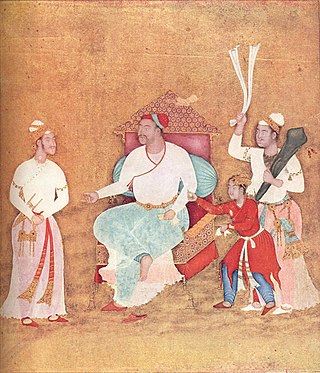
Ibrahim Qutb Shah Wali, also known by his Telugu names Malki BhaRama and Ibharama Chakravarti, was the fourth monarch of the kingdom of Golconda in southern India. He was the first of the Qutb Shahi dynasty to use the title "Sultan". He ruled from 1550 to 1580. He lived for seven years in exile at the court of Vijayanagara as an honoured guest of Rama Raya. Ibrahim is known for patronizing Telugu extensively because he was moved by a genuine love for the language.

Reddy is a caste that originated in India, predominantly settled in Andhra Pradesh and Telangana. They are classified as a forward caste.

<span class="mw-page-title-main">Gooty</span> Town in Andhra Pradesh, India

Gooty is a town in Anantapur district of the Indian state of Andhra Pradesh. It is the headquarters of Gooty mandal in Anantapur revenue division. The town is renowned for the Gooty hill fort.

<span class="mw-page-title-main">Anantapur district</span> District of Andhra Pradesh in India

Anantapur district officially: Anantapuramu district is one of the eight districts in the Rayalaseema region of the Indian state of Andhra Pradesh. The district headquarters is located in Anantapur city. It is one of the driest places in South India. In the year 2022, as part of re-organisation of districts, Sri Sathya Sai district was carved out.

<span class="mw-page-title-main">Kurnool district</span> District of Andhra Pradesh, India

Kurnool district is one of the eight districts in the Rayalaseema region of the Indian state of Andhra Pradesh after the districts are reorganised in April 2022. It is located in the north western part of the state and is bounded by Nandyal district in the east, Anantapur district in the south, Raichur district of Karnataka in the northwest, Bellary district of Karnataka in the west, and Jogulamba Gadwal district of Telangana in the north. It has a population of 2,271,686 based on the 2011 census. The city of Kurnool is the headquarters of the district.

Siruguppa is a town and headquarters of the Siruguppa taluk and second largest city in Ballari district after Hospete carved out of Ballari district of Indian state of Karnataka.

<span class="mw-page-title-main">Srisailam</span> Census Town in Andhra Pradesh, India

Srisailam is a census town in Nandyal district of the Indian state of Andhra Pradesh. It is the mandal headquarters of Srisailam mandal in Atmakur revenue division. It is located about 160 kilometres (99 mi) from the district headquarters Nandyal, 180 kilometres (112 mi) from Kurnool, and it is located about 264 kilometres (164 mi) from Vijayawada. The town is famous for Mallikarjuna Jyotirlinga Temple and is one of the holy pilgrimage sites for Saivism and Shaktism sects of Hinduism. The town is classified as both Jyotirlinga and Shakti Peetha.

Aspari is a village under the adoni revenue division in Kurnool district of Andhra Pradesh, India.

<span class="mw-page-title-main">Allagadda</span> Town in Andhra Pradesh, India

Allagadda is a town in Nandyal district of the Indian state of Andhra Pradesh. It is located in Nandyal Revenue division. The town is located at 15°08′00″N78°31′00″E.

Madakasira is a town with a population 19,432 in 2001 and also a mandal in Sri Satya Sai district in the state of Andhra Pradesh in India. It is located near the state border with Karnataka. The Madakasira Hill Fort in the town is a centrally protected monument of national importance.

<span class="mw-page-title-main">Ceded Districts</span> Former Indian territory ceded to the British East India Company

Ceded Districts is the name of an area in the Deccan, India that was 'ceded' to the British East India Company by the Nizam in 1800. The name was in use during the whole period of the British Raj, even though the denomination had no official weight for legal or administrative purposes. The area largely corresponds to the modern region of Rayalaseema.

<span class="mw-page-title-main">Bellary Fort</span>

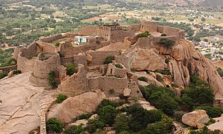
The Bellary Fort was built on top of a hill called the "Ballari Gudda" or the Fort Hill. It is situated in the historic city of Bellary, in the Bellary district, in Karnataka state, India. It was built in two parts namely, the Upper Fort and the Lower Fort. The Upper Fort was built by Hanumappa Nayaka, a feudatory of Vijayanagara Empire, but the Lower Fort was built by Hyder Ali in later part of the 18th century.

Ballari pronounced is a historic city in Bellary district in Karnataka state, India.

The Shahi Jamia Mosque is a mosque in Adoni, India. The masjid is a relic of architectural and cultural heritage. People from all sections of society and religions are allowed to visit and take pictures of this historical premise. It lies in the heart of the town, near the market, a very busy place within the town.

Hyderabad was the capital of the Indian states of Telangana and Andhra Pradesh. It is a historic city noted for its many monuments, temples, mosques and bazaars. A multitude of influences has shaped the character of the city in the last 400 years.

<span class="mw-page-title-main">History of Telangana</span>

The history of Telangana, located on the high Deccan Plateau, includes its being ruled by the Satavahana Dynasty, the Kakatiya Dynasty (1083–1323), the Musunuri Nayaks (1326–1356), the Delhi Sultanate, the Bahmani Sultanate (1347–1512), Golconda Sultanate (1512–1687) and Asaf Jahi dynasty (1724-1950).

<span class="mw-page-title-main">Deccanis</span> Ethnoreligious community in India

The Deccanis or Deccani People are an ethnoreligious community of Deccani-speaking Muslims who inhabit or are from the Deccan region of Central and Southern India, and speak the Deccani dialect. The community traces its origins to the shifting of the Delhi Sultanate's capital from Delhi to Daulatabad in 1327 during the reign of Muhammad bin Tughluq. Further ancestry can also be traced from immigrant Muslims referred to as Afaqis, also known as Pardesis who came from Central Asia, Iraq and Iran and had settled in the Deccan region during the Bahmani Sultanate (1347). The migration of Muslim Hindavi-speaking people to the Deccan and intermarriage with the local Hindus whom converted to Islam, led to the creation of a new community of Urdu-speaking Muslims, known as the Deccani, who would come to play an important role in the politics of the Deccan. Their language, Deccani Urdu, emerged as a language of linguistic prestige and culture during the Bahmani Sultanate, further evolving in the Deccan Sultanates.

<span class="mw-page-title-main">Madakasira Fort</span>

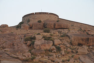
Madakasira Fort, also known as Simhagiri, is a hill fort located in the Madakasira town of Sri Sathya Sai district, in Andhra Pradesh, India. The Government of India has designated it as a Monument of National Importance.

References

  1. "MLA". AP State Portal. Archived from the original on 8 October 2014. Retrieved 30 October 2014.
  2. "Basic Information of Municipality". Municipal Administration & Urban Development Department, Govt. of Andhra. Archived from the original on 11 August 2014. Retrieved 18 January 2015.
  3. 1 2 3 4 "Andhra Pradesh (India): Districts, Cities, Towns and Outgrowth Wards – Population Statistics in Maps and Charts". citypopulation.de.
  4. 1 2 "Urban Agglomerations/Cities having population 1 lakh and above" (PDF). censusindia. The Registrar General & Census Commissioner, India. Retrieved 18 January 2015.
  5. Obulesul, M. Total literacy campaign. Discovery Publishing House, New Delhi 2006 p. 70 – 72. ISBN   978-81-8356-056-6. Accessed 4 November 2014.
  6. Commissioner and Director of Municipal Administration. Archived 11 February 2015 at the Wayback Machine Government of Andhra Pradesh. Accessed 17 January 2015.
  7. 1 2 Sen, S. Anglo-Maratha Relations, 1785–1796. Popular Prakashan, 1995, volume 2 p. 55. ISBN   9788171547890.
  8. Stein, B. The New Cambridge History of India. Cambridge University Press, 1989. Volume 1 p. 68. ISBN   978-0-521-26693-2.
  9. Welch S. India: Art and Culture, 1300–1900. Metropolitan Museum of Art, 1985 p. 48. ISBN   978-0-03-006114-1.
  10. 1 2 Hamilton, W. A Geographical, and Historical Description of Hindostan and the Adjacent Countries. Murray 1820 p. 334. Accessed at Google Books on 11 September 2015.
  11. Sharma R. Indian Art Treasures: Suresh Neotia collection. Mosaic Books 2006 p. 198 Accessed at Google Books 10 September 2015.
  12. Patel, A. and Leonard, K. Indo-Muslim culture in Transition. BRILL, 2011 p. 39 ISBN   9789004212091.
  13. Chaitanya K. A History of Indian Painting – Manuscript, Moghul and Deccani Traditions, Volume 2. Abhinav Publications, 1979 p. 75
  14. Singh, R. Mediaeval History of Rajasthan: Western Rajasthan. University of Michigan, 1992. Accessed at Google books 10 September 2015.
  15. Vasanth, R. and Basha, M. Islamic architecture of Deccan.
  16. Zebrowski, M. Deccani painting University of California Press, Berkeley, first edition, 1982. Accessed 9 October 2014
  17. Obeng P. Shaping Membership, Defining Nation: The Cultural Politics of African Indians in South Asia. Lexington Books, 2007 p.16. ISBN   978-0-7391-3121-3.
  18. Gribble, J. History of the Decan. Mittal Publications, 1990 p. 59 Accessed at Google Books 10 September 2015.
  19. Regani, S. Nizam-British Relations, 1724–1857. Concept Publishing Company, 1988 p. 52. ISBN   9788170221951
  20. Walker, J. and Walker, C. A gazetteer of Southern India: with the Tenasserim Provinces and Singapore. Pharoah, 1855. Accessed 9 October 2014.
  21. Wellesley, A.The Marquess Wellesley to the Resident at Hyderabad. Murry, 1836 p291.
  22. Kelsall, J. Manual of the Bellary District. W. Thomas, 1872 p. 5
  23. Butler, W. A Narrative of the Historical Events Connected with the Sixty-ninth Regiment. W. Mitchell, 1870 p. 67.
  24. Wellesley, A. The Dispatches of Field Marshal the Duke of Wellington. Parker, Furnivall, and Parker, 1844 Volume 1 p125.
  25. Bellary. The Madras quarterly medical journal, 1842 Volume 4 p. 4
  26. House of Commons Papers. H.M. Stationery Office, 1862. Vol 38 p. 233.
  27. The Imperial Gazetteer of India, Volume 7. Clarendon Press, Oxford, 1908 p. 158 – 176.
  28. Davis, M. Late Victorian Holocausts: El Nino Famines and the Making of the Third World. Verso Books, 2002 p. 112. ISBN   978-1-78168-061-2.
  29. Adoni. Falling Rain Genomics Accessed 9 October 2014.
  30. Narasaiah, M. Empowerment for Women. Discovery Publishing House, 2004 p.37 ISBN   817141785X, 9788171417858.
  31. "Sex Ratio". The Registrar General & Census Commissioner, India. Retrieved 29 August 2014.
  32. "Chapter–3 (Literates and Literacy rate)" (PDF). Registrar General and Census Commissioner of India. Retrieved 29 August 2014.
  33. "Kannada yet to attain primacy as the real first language in the land of its birth". India today.
  34. "Kannadigas should promote their language: Sait". The Hindu . 2 November 2004.[ dead link ]
  35. 1 2 Prasad, J. (ed.)Encyclopaedia of Agricultural Marketing. Mittal Publications, 2005 p. 278 ISBN   8170997453, 9788170997450.
  36. "Bus Stations in Districts". Andhra Pradesh State Road Transport Corporation. Archived from the original on 22 March 2016. Retrieved 9 March 2016.
  37. Francis, W. Gazetteer of South India. Mittal Publications, 2002 p. 441.
  38. "School Education Department" (PDF). School Education Department, Government of Andhra Pradesh. Archived from the original (PDF) on 27 December 2015. Retrieved 7 November 2016.
  39. "The Department of School Education – Official AP State Government Portal | AP State Portal". www.ap.gov.in. Archived from the original on 7 November 2016. Retrieved 7 November 2016.