Annamayya district

Last updated

Annamayya district
Annamayya at Rajampet, Kadapa District.JPG
108-feet Annamayya statue in Rajampet
Annamayya in Andhra Pradesh (India).svg
Location of Annamayya district in Andhra Pradesh
Annamayya district
Coordinates: 14°03′N78°45′E / 14.05°N 78.75°E / 14.05; 78.75
CountryFlag of India.svg  India
State Andhra Pradesh
Region Rayalaseema
Formed4 April 2022
Founded by Government of Andhra Pradesh
Named for Annamacharya
Headquarters Rayachoti
Largest city Madanapalle
Administrative Divisions
Government
   DFO P.Vivek IFS
   SP B.Krishna Rao IPS
   Lok Sabha constituencies Rajampeta
   MP P. V. Midhun Reddy
   Assembly constituencies 06
Area
[1]
  Total7,951 km2 (3,070 sq mi)
Population
 (2011) [2] [3]
  Total1,697,308
  Density210/km2 (550/sq mi)
Languages
  Official Telugu
Literacy
[4]
  Literates10,03,000
Time zone UTC+05:30 (IST)
Postal Index Number
516XXX, 517XXX
Website annamayya.ap.gov.in

Annamayya district is one of the eight districts in the Rayalaseema region of Andhra Pradesh, established in 2022. Rayachoti is the district administrative headquarters, and Madanapalle is the most populated city in the district.

Contents

Etymology

The district is named after the Annamacharya, [5] a 15th-century Hindu saint hailing from Tallapaka, Rajampeta, and the earliest known Indian musician to compose songs called sankirtanas in praise of the Lord Venkateswara. [6]

History

Rayachoti has many megalithic sites and stone circles. A noted megalithic site is at Devandlapalli [7] in Tsundupalle mandal of the district.

Nandalur [8] is an important Buddhist site in the district along with Tallapaka, Rajampeta, Konduru, Khazipeta in the district.

Annamayya district was formed on 4 April 2022 from parts of erstwhile Chittoor district and YSR districts as part of the reorganisation of Andhra Pradesh districts based on parliament constituency as unit. [9]

Geography

Annamayya district is the extreme southwestern district of Andhra Pradesh situated within the geographical co-ordinates of 13° 19’ 55” and 14° 42’ 32” of northern latitude and 78° 18’ 55” and 79° 20’26” eastern longitude. This district is part of Rayalaseema. The district is bounded on the north by Kadapa District, west by Sri Sathya Sai district and south by Chikballapur district and Kolar district of Karnataka and Chittoor district of Andhra Pradesh, east by Nellore and Tirupati districts of Andhra Pradesh. [10]

Natural resources

Palakonda Hills, also known as Seshachalam hills, Nallamalais and Lankamalais, are the major hill ranges in the district. Cheyyeru is the main river of the district. It joins Penneru at Gundlamada in Vontimitta mandal. Bonnet monkey (Macaca radiata) and Madras langur are commonly found. Tigers, leopards and other wild animals can still be seen in the hill ranges. Grey partridge (kamju in Telugu) and quail are commonly seen in the forests and countryside. Black soil occupies 23.7% area in the district. Barytes, lime stone and asbestos are the major minerals. The average annual rainfall is 743.7 mm. The rainfall generally increases from the north-west to the south-east in the district. [11]

Demographics

Religions in Annamayya district based on the 2011 census [12]
ReligionPercent
Hinduism
81.97%
Islam
17.25%
Other or not stated
0.78%

Based on the 2011 census, Annamayya district had a population of 16,97,308, of which 391,511 (23.07%) live in urban areas. Annamayya district has a sex ratio of 989 females per 1000 males. Scheduled Castes and Scheduled Tribes make up 2,28,501 (13.46%) and 62,475 (3.68%) of the population respectively. [2] :80–84 [3] :82–87

Languages of Annamayya district based on the 2011 census [13]

   Telugu (81.91%)
   Urdu (16.40%)
   Lambadi (1.04%)
  Others (0.65%)

Based on the 2011 census, 81.91% of the population spoke Telugu, 16.40% Urdu and 1.04% Lambadi as their first language. [13]

Administrative divisions

Map of mandals of Annamayya district Annamayya.png
Map of mandals of Annamayya district

Mandals

The list of 30 mandals in Annamayya district, divided into 3 revenue divisions, is given below.

Politics

There is only one parliamentary constituency namely Rajampet and six assembly constituencies in the district. [14]

The assembly constituencies are given below.

Constituency numberNameReserved for
(SC/ST/None)
Parliamentary constituency
125 Rajampet None Rajampet
127 Kodur SC
128 Rayachoti None
162 Thamballapalle None
163 Pileru None
164 Madanapalle None

The district is divided into three revenue divisions, Madanapalle, Rajampeta and Rayachoti, which are further subdivided into a total of 30 mandals, each headed by a sub-collector. [15]

Cities and towns

There are three municipalities [16] and one nagar panchayat in the district.

Municipal Bodies in Annamayya District
Ciy/TownCivil statusRevenue DivisionPopulation(2011)
Madanapalle MunicipalityMadanapalle1,80,180
Rayachoti MunicipalityRayachoti98,299
Pileru Major PanchayathRayachoti60,253
Rajampeta MunicipalityRajampeta57,277

Economy

Agriculture is the main economic activity. Paddy, groundnut, sunflower, cotton, and betel leaves are the major crops. Mango, papaya, banana, lemon and sweet orange are the major horticultural crops. As per the FY 2019–20, the gross cropped area is 1,71,617 hectares, while the gross irrigated area is 66,281 hectares. Pincha and Annamayya are the major irrigation projects. [17]

Transport

Roadways

301.59 km of National Highways, 330.46 km of State Highways 831.91 km of major district roads and 4,131.43 km of Panchayat Raj roads form the road network of the district. [18] NH 716,NH 40 and NH 71 pass through the district.The proposed NH 370 Nellore to Ananthapuram (Nellore–Rapur–Rajampet–Rayachoti–Kadiri–Ananthapuram) under planning passes through the district.

Railways

As of 2019–20, broad-gauge railway line of 195.13 km length with 24 railway stations part of Guntakal railway division of South Central Railway Zone serve the district. Madanapalle Road railway 12 km away from Madanapalle is on Guntakal-Pakala-Tirupati line that passes through the district. [18] [19] Kadapa railway station is the nearest major railway station at a distance of 51 km from Rayachoty.

Airways

The nearest small airport is Kadapa Airport, is 54 kilometres (34 mi) away from Rayachoty. The nearest airport is Tirupati International Airport is 130 kilometres (81 mi) away from Rayachoty.

Education

Rishi Valley School founded by Jiddu Krishnamurti which developed the popular multi-grade teaching methodology and Besant Theosophical College founded by Annie Besant are some of the famous educational institutions in Madanapalle.

Based on the 2011 census, the district has a 64.63% literacy rate, which is lower than the state literacy which stands at 67.35%. [1] As of 2019–20, the district has 1975 primary schools, 391 upper primary schools, 553 high schools, 128 junior colleges, 59 degree colleges and 82 professional and post graduate colleges. [18]

The district has several institutions for engineering, such as Annamacharya Institute of Technology & Sciences (AITS) [20] Narayanadri Institute of Science and Technology (NIST) [21] Madanapalle Institute of Technology & Science (MITS), Sri Sai Institute of Science (SSITS)

Tourism

Sri Parasurameshwara temple, Attirala Sri Parasurameshwara Temple, Attirala.jpg
Sri Parasurameshwara temple, Attirala
Sri Soumyanatha Swamy temple, Nandalur The Temple of Sri Soumyanatha Swamy Nandalur Kadapa AP INDIA.jpg
Sri Soumyanatha Swamy temple, Nandalur

Sri Parasurameshwara temple, Attirala and Sowmyanadha Swamy temple, Nandalur are the major religious places in the district. [22] Horsley Hills is a major hill station.

Volcanogenic bedded Barytes

Volcanogenic bedded Barytes located at Mangampet in Obulavaripalle mandal has been declared the National Geological Monuments of India by the Geological Survey of India (GSI), for their protection, maintenance, promotion and enhancement of geotourism. [23] [24] [25]

Notable people

1.Nallari Kiran Kumar Reddy Former CM United Andhra Pradesh

2.Kiran Abbavaram Tollywood Actor

3.Harishankar Reddy CSK IPL player

4.Bindu Madhavi Tamil Actress

5.Jiddu Krishnamurthy Indian philosopher

6.Gadikota Srikanth Reddy Indian Politician

Related Research Articles

<span class="mw-page-title-main">Chittoor</span> City in Andhra Pradesh, India

Chittoor is a city and district headquarters in Chittoor district of the Indian state of Andhra Pradesh. It is also the mandal and divisional headquarters of Chittoor mandal and Chittoor revenue division respectively. The city has a population of 153,756 and that of the agglomeration is 175,647.

<span class="mw-page-title-main">Rayalaseema</span> Geographic region of Andhra Pradesh in India

Rayalaseema is a geographic region in the Indian state of Andhra Pradesh. It comprises four southern districts of the State, from prior to the districts reorganisation in 2022, namely Kurnool, Anantapur, YSR, and Chittoor. Four new districts were created from these, namely Sri Sathya Sai, Nandyal, Annamayya, and Tirupati. As of 2011 census of India, the western four districts of the region had a population of 15,184,908 and cover an area of 77,424 km2 (29,894 sq mi).

<span class="mw-page-title-main">Madanapalle</span> City in Andhra Pradesh, India

Madanapalle is the largest city in Annamayya district and Rajampet Lok Sabha constituency of the Indian state of Andhra Pradesh. It is a Selection Grade Municipal City Council. Madanapalle is headquarters of Madanapalle Mandal,Madanapalle revenue division and PKM Urban Development Authority.

<span class="mw-page-title-main">Chittoor district</span> District of Andhra Pradesh, India

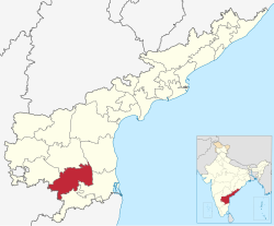
Chittoor district is one of the eight districts in the Rayalaseema region of the Indian state of Andhra Pradesh. It had a population of 18,72,951 at the 2011 census of India. It is a major market centre for mangoes, grains, sugarcane, and peanuts. The district headquarters is at Chittoor City.

<span class="mw-page-title-main">Kadapa district</span> District of Andhra Pradesh in India

Kadapa district is one of the twenty six districts in the Indian state of Andhra Pradesh. In 2022 reorganisation of Andhra Pradesh districts, the district boundary is largely restricted to Kadapa parliamentary constituency area. It is also one of the eight districts in the Rayalaseema region. Kadapa is the administrative headquarters for this district.

<span class="mw-page-title-main">Nellore district</span> District of Andhra Pradesh in India

Nellore district, officially known as Sri Potti Sriramulu Nellore district in Coastal Andhra Region, is one of the 26 districts in the Indian state of Andhra Pradesh. According to the 2011 Census, the district's population was 2,469,712 of which 29.07% was urban. Its administrative headquarters are located in Nellore city. Located in the Coastal Andhra region, the district is bordered by the Bay of Bengal to the east, Kadapa district and Annamayya district to the west, Prakasam district to the north, and Tirupati district to the south.

Rajampeta is a Municipality in Annamayya district of the Indian state of Andhra Pradesh, located in the Rayalaseema Region formed on the banks of Cheyyeru River. The town has an average elevation of 139 meters (456 ft). Rajampet is a Grade II Municipality which upgraded in 2019 and has an area of 35.38 square kilometres (13.66 sq mi). It consists of 29 election wards.

Rayachoti is a Municipality and District headquarters of Annamayya district which is formed after Rajampet of the Indian state of Andhra Pradesh. Also It is the headquarters of Rayachoti revenue division. It is one of the oldest towns in Andhra Pradesh.

<span class="mw-page-title-main">Pakala, Tirupati district</span> Town in Andhra Pradesh, India

Pakala is a town in Tirupati district of the Indian state of Andhra Pradesh. It is the mandal headquarters of Pakala mandal. It comes under Tirupati revenue division.

<span class="mw-page-title-main">Railway Koduru</span> Town in Andhra Pradesh, India

Railway Koduru is a town in Annamayya district of the Indian state of Andhra Pradesh, located in the Rayalaseema Region.

<span class="mw-page-title-main">Pileru</span> Town in Andhra Pradesh, India

Pileru is a census town in Annamayya district of Rayalaseema region of the Indian state of Andhra Pradesh. Pileru is located 197 Km North East of Bangalore, The Capital City Of Karnataka and 189 Km North West of Chennai, The Capital City Of Tamil Nadu and 464 Km South To The State Capital Amaravati .It is the mandal headquarters of Pileru mandal in Rayachoti revenue division. The name 'Pileru' means a "small river stream" or "Pilla Eru" in Telugu.

<span class="mw-page-title-main">Nandalur</span> Village in Andhra Pradesh, India

Nandalur is a village in Annamayya district of the Indian state of Andhra Pradesh. It is located in Nandalur mandal of Rajampeta revenue division. It is 10 km from Rajampet and 42 km from the District headquarters of the Cuddapah district on the State Highway connecting Cuddapah with Tirupati. It is located on the Cuddapah-Chennai highway, 38 km from Cuddapah and 11 km from Rajampeta. It is also close to other pilgrimage centres in Cuddapah district like Ontimitta, Polatala, Attirala and the famed birthplace of Sri Annamacharya, Tallapaka. It has an average elevation of 151 meters.

<span class="mw-page-title-main">Tallapaka, Andhra Pradesh</span> Village in Andhra Pradesh, India

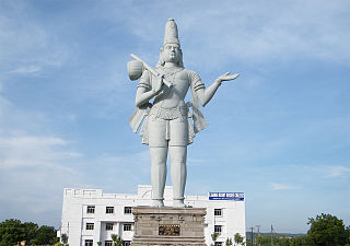
Tallapaka is a village in Rajampet mandal of Annamayya district in the Indian state of Andhra Pradesh. It is located 63 kms from Rayachoti and renowned as the birthplace of Tallapaka Annamacharya. Once the village was patronised as the living abode of Lord Venkateswara. Dr. Balaraju Krishnam Raju developed this village as a tourist location.

<span class="mw-page-title-main">Madanapalle revenue division</span> Revenue division in Annamayya district in Andhra Pradesh, India

Madanapalle revenue division is an administrative division in the Annamayya district of the Indian state of Andhra Pradesh. It is the largest and one of the 3 revenue divisions in the district with 11 mandals under its administration. Madanapalle serves as the headquarters of the division. The division has only one Municipal Corporation in Madanapalle. Administered by IAS cadre officer as SUB collector.

<span class="mw-page-title-main">Tirupati district</span> District in Andhra Pradesh, India

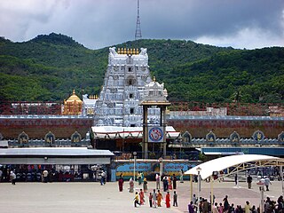
Tirupati district is one of the eight districts of Rayalaseema region in the Indian state of Andhra Pradesh. The district headquarters is located at Tirupati city. This district is known for its numerous historic temples, including the Hindu shrine of Tirumala Venkateswara Temple and Sri Kalahasteeswara temple. The district is also home to Satish Dhawan Space Centre, a rocket launch centre located in Sriharikota. The river Swarnamukhi flows through Tirupati, Srikalahasti, Naidupeta, Vakadu and join into the Bay of Bengal.

<span class="mw-page-title-main">Sri Sathya Sai district</span> District in Andhra Pradesh, India

Sri Sathya Sai district is a district in the Indian state of Andhra Pradesh. Its headquarters is at Puttaparthi. It was formed on 4 April 2022 from parts of the erstwhile Anantapur district.

Chinnamandyam mandal is one of the 30 mandals in Annamayya district in the Indian state of Andhra Pradesh. It is a part of Rayachoti revenue division. The mandal used to be a part of Kadapa district and was made part of the newly formed Annamayya district on 4 April 2022.

Ramapuram mandal is one of the 30 mandals in Annamayya district in the Indian state of Andhra Pradesh. It is a part of Rayachoti revenue division. The mandal used to be a part of Kadapa district and was made part of the newly formed Annamayya district on 4 April 2022.

Rayachoti mandal is one of the 30 mandals in Annamayya district in the Indian state of Andhra Pradesh. It is a part of Rayachoti revenue division.

Sambepalli mandal is one of the 30 mandals in Annamayya district in the Indian state of Andhra Pradesh. It is a part of Rayachoti revenue division. The mandal used to be a part of Kadapa district and was made part of the newly formed Annamayya district on 4 April 2022.

References

  1. 1 2 CPO 2022, p. IX.
  2. 1 2 "District Census Hand Book – YSR Kadapa" (PDF). Census of India . Registrar General and Census Commissioner of India.
  3. 1 2 "District Census Hand Book – Chittoor" (PDF). Census of India . Registrar General and Census Commissioner of India.
  4. CPO 2022, p. iX.
  5. Apparasu, Srinivasa Rao (5 April 2022). "Andhra adds 13 new districts with aim to boost governance". Hindustan Times. Retrieved 9 April 2022.
  6. "Life and Times of Sri Tallapaka Annamacharya". Svasa.org. Archived from the original on 18 September 2009. Retrieved 20 June 2013.
  7. "Megalithic burial site found in Kadapa". The Hindu. Chennai, India. 24 June 2012.
  8. Mitra, Debala, ed. (1983). Indian Archaeology 1979–80—A Review (PDF). New Delhi: Archaeological Survey of India, Government of India. Archived from the original (PDF) on 8 May 2012.
  9. CPO 2022.
  10. CPO 2022, p. III.
  11. CPO 2022, p. IV-V.
  12. "Population by Religion - Andhra Pradesh". censusindia.gov.in. Registrar General and Census Commissioner of India. 2011.
  13. 1 2 "Table C-16 Population by Mother Tongue: Andhra Pradesh". Census of India . Registrar General and Census Commissioner of India.
  14. CPO 2022, p. XVI.
  15. "Revenue Division". Annamayya district. Retrieved 9 April 2023.
  16. CPO 2022, p. XV.
  17. CPO 2022, p. V-VI.
  18. 1 2 3 CPO 2022, p. VI.
  19. "Guntakal division map". South central railway. Retrieved 23 April 2023.
  20. "Annamacharya Institute of Technology & Sciences - Rajampet". www.aitsrajampet.ac.in.
  21. "NIST Home page". NIST, Rajampet. Retrieved 22 April 2023.
  22. CPO 2022, p. VII.
  23. "National Geological Monument, from Geological Survey of India website". Archived from the original on 12 July 2017. Retrieved 21 January 2019.
  24. "Geo-Heritage Sites". pib.nic.in. Press Information Bureau. 9 March 2016. Archived from the original on 1 December 2017. Retrieved 15 September 2018.
  25. National geo-heritage of India (PDF). INTACH. Archived from the original (PDF) on 11 January 2017.

Books

CPO (2022). District Hand Book of Statistics – 2020 Annamayya district (PDF).