Cambridge is a city in Middlesex County, Massachusetts, in the United States. It is a suburb in the Greater Boston metropolitan area, located directly across the Charles River from Boston. The city's population as of the 2020 U.S. census was 118,403, making it the most populous city in the county, the fourth-largest in Massachusetts, behind Boston, Worcester, and Springfield, and ninth-most populous in New England. The city was named in honor of the University of Cambridge in Cambridge, England, which was an important center of the Puritan theology that was embraced by the town's founders.

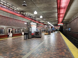
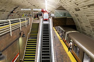
The Red Line is a rapid transit line operated by the Massachusetts Bay Transportation Authority (MBTA) as part of the MBTA subway system. The line runs south and east underground from Alewife station in North Cambridge through Somerville and Cambridge, surfacing to cross the Longfellow Bridge then returning to tunnels under Downtown Boston. It continues underground through South Boston, splitting into two branches on the surface at JFK/UMass station. The Ashmont branch runs southwest through Dorchester to Ashmont station, where the connecting light rail Ashmont–Mattapan High Speed Line continues to Mattapan station. The Braintree branch runs southwest through Quincy and Braintree to Braintree station.
Alewife station is a Massachusetts Bay Transportation Authority (MBTA) intermodal transit station in the North Cambridge neighborhood of Cambridge, Massachusetts. It is the northwest terminal of the rapid transit Red Line and a hub for several MBTA bus routes. The station is at the confluence of the Minuteman Bikeway, Alewife Linear Park, Fitchburg Cutoff Path, and Alewife Greenway off Alewife Brook Parkway adjacent to Massachusetts Route 2, with a five-story parking garage for park and ride use. The station has three bike cages. Alewife station is named after nearby Alewife Brook Parkway and Alewife Brook, themselves named after the alewife fish.

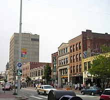
Harvard station is a rapid transit and bus transfer station in Cambridge, Massachusetts. Located at Harvard Square, it serves the MBTA's Red Line subway system as well as MBTA buses. Harvard averaged 18,528 entries each weekday in FY2019, making it the third-busiest MBTA station after Downtown Crossing and South Station. Five of the fifteen key MBTA bus routes stop at the station.
Porter station is a Massachusetts Bay Transportation Authority (MBTA) transit station in Cambridge, Massachusetts. It serves the Red Line rapid transit line, the MBTA Commuter Rail Fitchburg Line, and several MBTA bus lines. Located at Porter Square at the intersection of Massachusetts and Somerville Avenues, the station provides rapid transit access to northern Cambridge and the western portions of Somerville. Porter is 14 minutes from Park Street on the Red Line, and about 10 minutes from North Station on commuter rail trains. Several local MBTA bus routes also stop at the station.

Route 2 is a 142.29-mile-long (228.99 km) major east–west state highway in Massachusetts, United States. Along with Route 9 and U.S. Route 20 to the south, these highways are the main alternatives to the Massachusetts Turnpike/I-90 toll highway. Route 2 runs the entire length of the northern tier of Massachusetts, beginning at the New York border, where it connects with New York State Route 2, and ending near Boston Common in Boston. Most of the route is an expressway through the northern tier of Massachusetts, with the longest surface road segments being the western portion. Older alignments of Route 2 are known as Route 2A.
The Massachusetts Bay Transportation Authority (MBTA) operates 152 bus routes in the Greater Boston area. The MBTA has a policy objective to provide transit service within walking distance for all residents living in areas with population densities greater than 5,000 inhabitants per square mile (1,900/km2) within the MBTA's service district. Much of this service is provided by bus. In 2023, the system had a ridership of 91,459,700, or about 303,300 per weekday as of the fourth quarter of 2023.

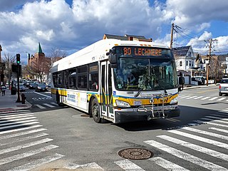
Key bus routes of the Massachusetts Bay Transportation Authority (MBTA) system are 15 routes that have high ridership and higher frequency standards than other bus lines, according to the 2004 MBTA Service Policy. Together, they account for roughly 40% of the MBTA's total bus ridership. These key bus routes ensure basic geographic coverage with frequent service in the densest areas of Boston, and connect to other MBTA services to give access to other areas throughout the region.
The Middlesex and Boston Street Railway (M&B) was a streetcar and later bus company in the area west of Boston. Streetcars last ran in 1930, and in 1972, the company's operations were merged into the Massachusetts Bay Transportation Authority (MBTA).

Alewife Brook Reservation is a Massachusetts state park and urban wild located in Cambridge, Arlington, and Somerville. The park is managed by the state Department of Conservation and Recreation and was established in 1900. It is named for Alewife Brook, which was also historically known as Menotomy River, a tributary of the Mystic River.

Route 2A is a 98.5-mile-long (158.5 km) east–west state highway in Massachusetts. It exists in several sections, mainly as parts of former Route 2 that have been moved or upgraded. Route 2A runs from Greenfield in the west to Boston in the east. It formerly extended to Shelburne Falls in Buckland in the west, but as of 2007, the route terminates at Interstate 91 (I-91) in Greenfield.

The Fitchburg Cutoff was a rail line running 2.8 miles (4.5 km) from Brighton Street in Belmont, Massachusetts, to Somerville Junction in Somerville, Massachusetts. It was constructed in two segments in 1870 and 1881 to connect the Lexington Branch and Central Massachusetts Railroad to the Boston and Lowell Railroad. Passenger service lasted until 1927. Freight service ended in 1979–80 to allow construction of the Red Line Northwest Extension; the line was abandoned in three sections in 1979, 1983, and 2007.
The Lexington and West Cambridge Railroad was a railroad company chartered in 1845 and opened in 1846 that operated in eastern Massachusetts. It and its successors provided passenger service until 1977 and freight service until 1980 or early 1981.

Alewife Brook Parkway is a short parkway in Cambridge and Somerville, Massachusetts. It is listed on the National Register of Historic Places. It begins at Fresh Pond in Cambridge, and heads north on the east bank of Alewife Brook, crossing into West Somerville and ending at the Mystic River on the Medford town line, where it becomes Mystic Valley Parkway. The entire length of Alewife Brook Parkway is designated as part of Massachusetts Route 16 (Route 16), while the southernmost sections are also designated as part of Route 2 and U.S. Route 3 (US 3). It is managed by the Department of Conservation and Recreation with the Massachusetts Department of Transportation responsible for bridge maintenance.

Bedford Depot is a historic railroad depot in Bedford, Massachusetts, United States. Bedford was the junction of the Reformatory Branch and the Lexington Branch of the Boston and Maine Railroad; it saw passenger service until 1977 as the stub of the Lexington Branch. The original 1874 depot and 1877 freight house are listed on the National Register of Historic Places; along with a restored Budd Rail Diesel Car, they form the centerpieces of the Bedford Depot Park.
Cambridge Highlands also known as "Area 12", is a neighborhood of Cambridge, Massachusetts bounded by the railroad tracks on the north and east, the Belmont town line on the west, and Fresh Pond on the south. In 2005 it had a population of 673 residents living in 281 households, and the average household income was $56,500.

This is a list of roundabouts in the state of Massachusetts in the United States. Intersections that are called traffic circles or roundabouts in the rest of the US are referred to as "rotaries" in Massachusetts, as well as other parts of New England including parts of Connecticut, New Hampshire, Maine Rhode Island, & Vermont.
The Massachusetts Bay Transportation Authority operates subway, bus, commuter rail, and ferry service in the Greater Boston region. Boston has some of the highest rates of non-motorized commuting in the United States, including high bicycle usage. The MBTA offers certain provisions for riders wishing to make part of their trips by bicycle. The agency allows bicycles to be carried on all fixed-route services except the Green Line and the Ashmont-Mattapan High Speed Line light rail lines, although they are restricted on the commuter rail and heavy rail subway services at peak hours. Bicycle storage areas are offered at many stations, with "Pedal and Park" locking bicycle cages at certain high-usage stations.

Arlington station was a regional rail station in Arlington, Massachusetts. Located in downtown Arlington, it served the Lexington Branch. It was closed in January 1977 when service on the Lexington Branch was suspended.

Lake Street station was a commuter rail station on the Lexington Branch, located in the East Arlington section of Arlington, Massachusetts. The line opened as the Lexington and West Cambridge Railroad in 1846, with a station at Pond Street among the earliest stops. It was renamed Lake Street in 1867. The Boston and Lowell Railroad (B&L) acquired the line in 1870 and built a new station building in 1885. Service continued under the Boston and Maine Railroad (B&M) – successor to the B&L – though it declined during the 20th century. Lake Street station and three others on the line were closed in May 1958. The Massachusetts Bay Transportation Authority (MBTA) began subsidizing service in 1965, and Lake Street station reopened in March 1968. All passenger service on the Lexington Branch ended on January 10, 1977; it was converted into the Minuteman Bikeway in the early 1990s.