Mission Hill is home to several hospitals and universities, including Brigham and Women's Hospital and New England Baptist Hospital.[3] Though first settled in the 17th century, the neighborhood is known for its brick row houses and triple decker homes of the late 19th century.[4] It's also home to several community centers, several neighborhood groups, one branch of the Boston Public Library, one high school, and one newspaper.
The neighborhood's population was estimated at 15,883 in 2011.[5] Of these 42.7% are white, 18.0% are black, 17.5% are Hispanic, 14.1% are Asian, 1.2% are multiracial, and 1.4% identify as "Other".[5]
Geography
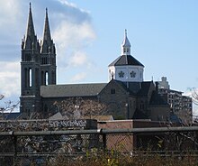
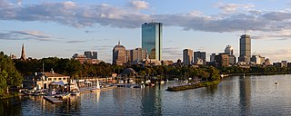
View of Mission Church and Boston skyline from near top of Mission Hill
The neighborhood has two main commercial streets: Tremont Street and Huntington Avenue. Both have several small restaurants and shops. Mission Hill is at the far western end of Tremont Street, with Government Center at the far eastern end. Mission Hill's main zip code is 02120. Additionally, a very small portion of the southeastern edge uses the code 02130, areas adjacent to the Longwood Medical Area use 02115 and two streets on the far western edge use 02215.
Parker Hill, Back of The Hill, and Calumet Square are areas within the Mission Hill, an officially designated neighborhood in Boston (as attested by numerous signs prohibiting parking without a suitable Mission Hill neighborhood residential sticker, which only residents can procure legally).
Brigham Circle, located at the corner of Tremont and Huntington is the neighborhood's commercial center, with a grocery store, drug stores, bistros, banks and taverns. One block up the hill from Brigham Circle is Boston's newest park, Kevin W. Fitzgerald Park (formerly Puddingstone Park)[6][7] created when a new $60-million mixed use building was completed in 2002.
Also nearby is the recently restored Parker Hill Library,[9] the neighborhood branch of the Boston Public Library,[10] and designed by architect Ralph Adams Cram in 1929. The city used eminent domain to acquire the land for both the library and the adjacent Mission Hill playground.
Atop the hill are the New England Baptist Hospital and the Parker Hill Playground, which extends from the hospital grounds down Parker Hill Avenue.
Location
The neighborhood is roughly bounded by Columbus Avenue and the Boston neighborhood of Roxbury to the east, Ruggles Street to the northeast and the Olmsted designed Riverway/Jamaicaway, and the town of Brookline to the west.[11] The Historic District was designated by the Boston Landmarks Commission in 1985 and is roughly bounded by Smith Street, Worthington Street, Tremont Street (to the south), and Huntington Avenue (to the west). The Mission Hill neighborhood is immediately north of the Boston neighborhood of Jamaica Plain. It is served by the MBTAGreen Line E branch and the Orange Line, and is within walking distance of the Boston Museum of Fine Arts and the Gardner Museum. "The Hill" overlaps with about half of the Longwood Medical and Academic Area, home to 21 health care, research, and educational institutions which together provides the largest employment area in the City of Boston outside of downtown Boston. Due to these adjacencies, the neighborhood is often struggling with institutional growth taking residential buildings and occupying storefront commercial space. Recent years have seen new retail stores, restaurants, and residential development giving the neighborhood a stronger political voice and identity, as some of the educational institutions have made commitments to house all or most of their about 2000 undergraduate students in newly erected campus housing, including several new high-rise dormitories. People aged 20 to 24 account for 32% of the population currently living in Mission Hill.
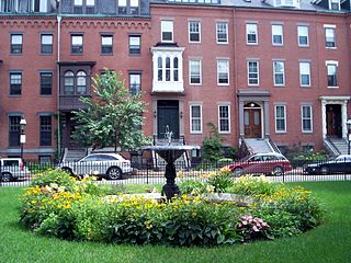
The Mission Hill Triangle is an architectural conservation district with a combination of freestanding houses built by early wealthy landowners, blocks of traditional brick rowhouses, and many triple-deckers.[12] Many are now condominiums, but there are also several two-family and some single-family homes.
The neighborhood was named in March 2008 as one of 25 "Best ZIP Codes in Massachusetts" by The Boston Globe, citing increased value in single-family homes, plentiful restaurants and shopping, a marked racial diversity, and the behavioral fact that 65% of residents walk, bike, or take public transit to their work.[13]
Green space
There are a few large parks in Mission Hill for walking or sitting.
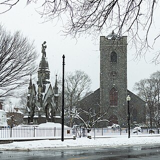
One is called Kevin W. Fitzgerald Park. Formerly named Puddingstone Park because of the local rock sources, the park includes lawn space and asphalt walkways for people to walk on. The walkway is lined with benches for people to rest and enjoy the various views such as Lower Roxbury, the Fenway, and Back Bay. This park was previously one of the five quarries in Boston. This park was known as the Harvard Quarry. The operation of the quarry was ceased around 1910 and this left a 65-foot-high quarry wall. In the 1990s, the open space planning committee worked on preserving public access to the quarry. The community and the developer decided together that the walls of the old quarry would be preserved and they would create a new 6-acre open space for the community at the top of the puddingstone bowl. Harvard Quarry Urban Wild was then named Puddingstone Park. In November 2006, the park was renamed Kevin Fitzgerald Park in honor of the former Massachusetts State Representative.[14] Most of the land is already being developed on for more housing and institutional purposes. Only 6.2 acres of land are protected for preservation of public access.[15]
McLaughlin Park is another park located in Mission Hill. An article posted in the Mission Hill Gazette on April 3 talked about the park being renovated on a $430,000 budget. A direct quote taken from the article states the plan for the renovations, "The City presented a plan for the renovation in September that would lay a loop path around the upper terrace; build an overlook area along the southeastern portion of the terrace; repair Ben's Tower; add a new set of stairs from the upper terrace to the lower terrace; and address other maintenance issues."[16] Ben's tower is a memorial for a child named Ben who was from Mission Hill and enjoyed playing in the McLaughlin Park. Ben died of cancer.
The Butterfly Garden located on the Back of The Hill is another lovely gated garden, smaller in size.
Visual appearance
Historically, Mission Hill Main Streets, a neighborhood affiliation of Boston Main Streets, has worked to neaten and improve the 'main streets' where small businesses operate. Business operators with cashflow restraints can apply for business mentoring, and loans and/or grants for awnings and structural improvements.
The Community Alliance of Mission Hill,[17][non-primary source needed] is an unincorporated network of neighbors, largely property owners, who have combined to review trends and developments in Mission Hill, specifically zoning and building requests.[18] The Mission Hill Beautification Task Force (MHB Task Force) is a CAMH sub-network focused upon cleanup and preservation, beautification, and public outreach and education and concerning well-being and the quality of life in Mission Hill.
According to the American Community Survey (ACS), Mission Hill's population was 15,883 in 2011. It listed 47.8% of the people in the community as White, 18.0% as Black or African American, 17.5% as Hispanic or Latino, 14.1% as Asian, 1.2% as "two or more races", and 1.4% as "other". Given its proximity to many colleges and universities, and because it houses several dormitories, ages in the neighborhood centered near the early to mid-20s. The ACS estimated residents between the ages 20–24 make up most of the population of Mission Hill, Boston.[5]
The 2011 ACS listed median household income in Mission Hill as $33,432 during a 12-month span. 21.1% of the households made less than $10,000 yearly. The median family income during a 12-month span was $36,237. The highest percent of family income accounts for 12.0% and they make between $75,000 to $99,999 yearly. Out of 6,230 households, 1,300 received food stamps/SNAP over a 12-month span.[5] However, Mission Hill Neighborhood Housing Services claims that "Mission Hill's population of 18,722 people is racially and economically diverse" on its website.[19] Seeming disparities in statistics might recurringly result from the very large number of short-term undergraduates and visiting international faculty, postdocs, researchers, and professional degree candidates who may or may not appear in statistical data sets that are cited for publication.
History
Industry began in the area as early as the 17th century.
Much of the early history of Mission Hill through 1978 is covered in a 65-minute documentary video, Mission Hill and the Miracle of Boston, a widely used documentary which was directed by Richard Broadman (died 2002) of the Museum of Fine Arts and released in 1978. The film recounts the events that led to the Urban Renewal Program in Boston and its aftermath by showing how these events unfolded in Mission Hill.[20]
17th and 18th century
Like the adjacent neighborhood of Jamaica Plain to the south, Mission Hill was once a neighborhood of adjacent Roxbury before Roxbury's annexation by Boston. According to maps from the period, it was often referenced as Parker Hill (which is the name of the geographic feature in the area). After annexation (and more rapidly in recent years) the area slowly came to be considered a separate neighborhood of its own right. The majority of government, commercial, and institutional entities list "Mission Hill" in the breakdown of Boston neighborhoods and its boundaries generally agreed upon.
Until the American Revolution, Mission Hill supported large country estates of wealthy Boston families. Much of the area was an orchard farm, originally owned by the Parker family in the 18th century. Peter Parker married Sarah Ruggles, whose family owned large areas of land including most of what became known as Parker Hill (later renamed Mission Hill).[4] Parker's life ended when a barrel of his own cider fell on him. (Much of this story is outlined in "The History of Peter Parker and Sarah Ruggles", a book by John William Linzee, published in 1913.) An annual 'cider press' neighborhood event is held in the 'top of the hill' park adjacent to New England Baptist Hospital, commemorating this neighborhood narrative.
The orchard continued for some time thereafter, but gradually pieces of the land were sold and developed. Boston's reservoir was once located at the top of the hill. Many of the older apple trees along Fisher Avenue and in an undeveloped area of the playground are probably descendants of the Parker family's original trees. The lower portion of the eastern hill was a puddingstonequarry with large swaths owned by merchants Franklin G. Dexter, Warren Fisher, and Fredrick Ames.
View from top of Parker Hill, 1910
Maps of the area indicate Mission Hill development began before the Fenway and Longwood Medical Area. Huntington Avenue, now one of the main connections to the rest of Boston, once stopped at the intersection of Parker Street, near the present-day site of the Museum of Fine Arts. Up until that time, Mission Hill was connected via Parker Street (a man-made raised passage between the Stony Brook and the Muddy River – both which formed a tidal flat into the Charles River) all the way to Boylston Street in the Back Bay. Part of what was once Parker Street is now called Hemenway Street. The once main intersection of Parker Street and Huntington Avenue has been traffic-engineered, cutting the straight-line road in two and forcing traffic to first turn onto Forsyth Way to make the connection. Many other streets leading into Mission Hill were also realigned and/or renamed at Huntington Avenue (including Longwood Avenue/McGreevey Way, Smith/Shattuck Street, Vancouver Street, and Palace Road/Worthington Street), limiting both pedestrian and vehicular access.
19th century
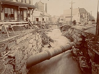
The first brewery was established at the foot of Parker Hill in the 1820s. By the 1870s beer production was the main industry in Mission Hill, and many breweries lined the Stony Brook (now a culvert running along the Southwest Corridor). Most of Boston's breweries were once located in Mission Hill, but three periods of Prohibition (1852–1868, 1869–1875 and 1918–1933) and the nation's transition from local breweries to national mass-produced brands took their toll on business. Many of the remaining buildings are now being converted into loft condominia.
After the 1880s and the re-routing of the Muddy River by Frederick Law Olmsted, Huntington Avenue was joined from Parker Street to Brigham Circle, creating the Triangle District. (Maps from the time indicate that Huntington Avenue from Brigham Circle to the Brookline line was named Tremont Street.)
Mission Church
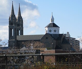
Development began in earnest in the mid-19th century. In 1870, the Redemptorist Fathers built a humble wooden mission church that was replaced by an impressive Roxbury puddingstone structure in 1876. In 1910, dual-spires were added that now dominate the skyline. The church was elevated to basilica in 1954 by Pope Pius XII and is one of less than 100 in the United States.[21] Officially named Our Lady of Perpetual Help after the icon of the same name, it is uniformly referred to as "Mission Church", even by its own parishioners. Due to a sloping foundation of this landmark, the west cross tops its tower at 215 feet (66m); the other spire is two feet shorter. The length of the church is also 215 feet (66m), presenting a perfect proportion.
At one time, the Basilica was a campus of buildings; the Queen Anne style Sister's Convent and Grammar School (1888–1889, Henry Burns) and the Romanesque Revival St. Alphonsus Hall (1898, Franz Joseph Untersee) administered by the parish. The church closed Mission Church High School in 1992, but a parochial elementary school still remains. The sale of these buildings at 80–100 Smith Street allowed much of the church to be restored. The sold buildings are currently planned to be used for 'Basilica Court,' a 229-unit residential complex, developed by Weston Associates, Inc. The Hall was the club headquarters for the St. Alphonsus Association founded in 1900. It was the preeminent social and athletic Catholic men's organization for nearly 50 years and its 1000-seat theatre held many community, political, and theatrical events.
Another example of high religious architecture is the Annunciation Greek Orthodox Cathedral of New England at 514 Parker Street at the eastern edge of the neighborhood. Referred to as the "mother church" of the Greek Orthodox Church in New England, it is the cathedral of the Diocese of Boston and the seat of Bishop Methodios Tournas. Built between 1892 and 1927, it is one of the oldest Greek churches in the United States, a Boston landmark, and is listed on the National Register of Historic Places. In 1927 a Greek artist was commissioned to decorate the cathedral with Byzantine iconography. The radiant stained glass windows and large crystal chandeliers also contribute to the visual majesty of the cathedral's interior.
Puddingstone plays a historic role in the area. The large puddingstone quarry that ran between Tremont Street and Allegany Street produced the stone foundations of most of the late-19th-century houses in the neighborhood. This locally sourced material made quick construction of working-class housing possible. Some structures around the Tremont Street/Parker Street intersection are made entirely of the material, including 682–688 Parker Street, 2–5 Sewall Street and 1472–74 Tremont Street (1856, David Connery, mason).
Most of the houses in the neighborhood are stone foundations and wood construction, but the Triangle Historic District along Huntington Avenue is stone and brick, and one of only eight such districts in Boston given landmark status by the city. These seventy-one buildings bordered by Huntington Avenue, Tremont Street, and Worthington Street exemplify the development of the neighborhood from the 1870s through the 1910s. Construction of this area was begun in 1871. The Helvetia, a distinctive apartment hotel, was built at 706–708 Huntington Avenue in 1884–1885; a Georgian revival apartment building known as The Esther was built at 683 Huntington/142–148 Smith Street in 1912. Both buildings continue have retail on the ground floor and apartments above. Similar row houses line one side of Delle Avenue a few blocks away from the Triangle District. Taller and larger brick row houses also line Huntington Avenue, Wait Street, and South Huntington.
By 1894, the electric streetcar was in operation on Huntington Avenue. Builder-developers began cutting streets through the hillside farmland and building homes for commuters on Parker Hill Avenue, Hillside Street, and Alleghany Street. An excellent example from this era is the Timothy Hoxie House at 135 Hillside Street. A freestanding Italianate villa, it was built in 1854 across from its present location. The Hoxie family left Beacon Hill for pastoral Mission Hill. Single-family houses of this size are rare today in the area. Demand for housing went up and builders turned to building multifamily dwellings, generally constructed on smaller lots.
The carpenter-contractor John Cantwell lived in the Gothic Revival cottage at 139 Hillside Street, and purchased the Hoxie House after Timothy's death. He moved the house to its present site so that upper Sachem Street could be cut through. Cantwell also developed triple deckers on adjacent lots on Darling and Sachem Streets. In 1890, he subdivided the lot on which the Hoxie House stood and built triple-deckers at 17 and 19 Sachem Street.
By the 1890s, there was a more urban feel to the neighborhood and the hill was covered in triple-deckers. Calumet, Iroquois and other streets with Native American names were built up within ten years into a dense neighborhood of triple deckers in the Queen Anne style. The Queen Anne style is prevalent in Mission Hill because this building boom coincided with the popularity of this style. A restoration of this style of houses along Parker Street is becoming something of a Polychrome Row.
Row Houses Along Parker Street
Before 1900, the Georgian RevivalNew England Baptist Hospital (at the time, the Robert Breck Brigham Hospital) at 125 Parker Hill Ave was one of the few institutions in the neighborhood. Other soon followed, moving from their downtown locations to the Mission Hill/Longwood area for more space and less expensive land (along with the completion of the Emerald Necklace). In 1906, the Harvard Medical School moved into five buildings on Longwood Avenue. Wentworth Institute at 360 Ruggles Street began building in 1911. In 1912, the then Peter Bent Brigham Hospital (now Brigham & Women's Hospital) opened on Brigham Circle. In 1914, Children's Hospital also moved to Longwood Avenue. Beth Israel Deaconess was constructed a short time later.[22]
20th century
In the late 19th century through the 1970s, the neighborhood was once home to large numbers of families of recent immigrant descent: mostly Irish, but also Germans, Italians, and others. After the 1950s, the combined effects of urban renewal, white flight, and institutional growth caused many to flee the neighborhood. In the early 1960s, the Boston Redevelopment Authority razed several homes in the Triangle District section of the neighborhood to make way for the Whitney Redevelopment Project,[23] which are three high-rise towers along St. Alphonsus Street. They include Charlesbank Apartments (276-unit highrise that became a limited equity co-op), Back Bay Manor (270 units, now known as CityView at Longwood), and Franklin Square Apartments (formerly Back Bay Towers – 146 units, now known as The Longwood). This project was one of Boston's earliest redevelopment projects not funded by federal renewal monies.[22] Eastward across St. Alphonsus Street is Mission Main, one of the nation's oldest public housing developments. The original thirty-eight 3-story brick structures built between 1938 and 1940 were demolished in the mid-1990s and replaced with 535 new apartments with a mix of subsidized and market-rate units.[24]
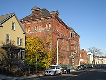
Former Alley Brewing Company building at 117 Heath Street.
Breweries included A.J. Houghton (1870–1918) at 37 Station Street, American Brewing Co. at 251 Heath Street(1891–1934)—now American Brewery Lofts, Union Brewing Co. on Terrace Street (1893–1911), Roxbury Brewing Co. at 31 Heath Street (1896–1899)—the building is now home to the Family Service of Greater Boston, Croft Brewing Co. (1933–1953), Burkhardt Brewing Co. (1850–1918), Alley Brewing Co. at 117 Heath Street (1886–1918) and the Highland Springs Brewery/Reuter & Co. (1867–1918) on Terrace Street—the building is often referred to as The Pickle Factory and is in planning for conversion to housing.
The former Oliver Ditson Company building and later Pickle Factory building, 2007
From 1916 through the early 1950s, Gordon College, related to the Ruggles Street Baptist Church formerly on Ruggles Street, was on Evans Way in the Fenway on the edge of Mission Hill. When Gordon moved out of the neighborhood near the Museum of Fine Arts and relocated to Wenham, Massachusetts, Wentworth Institute of Technology bought the land. The 7-story Alice Heyward Taylor Apartments were completed in 1951;[25] since that time, they have been completely renovated.[26]
In the late 1960s, Harvard University, through straws, thus concealing the purchases from the neighborhood, bought the wood frame and brick houses along Francis, Fenwood, St. Alban's, Kempton Streets, and part of Huntington Avenue, and announced plans to demolish the buildings. Most were replaced with the Mission Park residential complex of towers and townhomes in 1978 after neighborhood residents organized the Roxbury Tenants of Harvard Association to convince Harvard to rebuild. The tower sits on the site of the House of the Good Shepard, once a large and prominent orphanage. The gates to the complex and the brick wall along Huntington survive from this era.
1874 Map of Roxbury Crossing
Also in the 1960s the federal government proposed to extend Interstate 95 into the center of Boston and began buying property and demolishing houses along the Boston and Providence Rail Road. This area, once known as Pierpoint Village after the Pierpoint family and their mills (the earliest of which began in the 1650s), was a stop along the Boston & Providence Railroad in the 1840s, and was once a vibrant commercial area with the 749-seat Criterion Theatre, a Woolworth's, and some restaurants catering to market tastes.
In 1962, the Mission Hill public housing development had 1,024 families (all white), while the Mission Hill Extension project across the street had 580 families (of which 500 were black), and in 1967 when the Boston city government under MayorJohn F. Collins (1960–1968) agreed to desegregate the developments, the projects were still 97 percent white and 98 percent black respectively.[27]
The Interstate project was shelved by the governor in 1971 after freeway revolts. Ten years later saw the creation of the Southwest Corridor, a park system with bike and pedestrian trails that lead into the center of Boston. In November 2007, the MBTA awarded Mission Hill Housing Services rights to develop a new 10-story mixed-use building on what is known to the Boston Redevelopment Authority (now the Boston Planning and Development Agency – BPDA) as "Parcel 25", across from the Roxbury Crossing subway station.
By the early 1970s, the area was deemed dangerous and most White people and affluent Black people had moved away. The 1989 incident involving Charles Stuart further intensified this view. With property values low, many of the homes were bought by slum lords and converted into rental housing. The inexpensive rents brought many students from nearby colleges and universities, especially MassArt, Northeastern University, Wentworth Institute of Technology and the School of the Museum of Fine Arts, which has a large studio building in the neighborhood.[28] The Mission Hill Artists Collective now hosts Open Studios[29] in the fall of each year.
As past fears faded by the mid-1990s, the area began to change as homeowners moved into newly converted condominia to take advantage of the fantastic views of the city and proximity to the Longwood Area, the MBTA and downtown Boston.
21st century
Today, the neighborhood is briskly gentrifying[30] and diversifying in favor of a mix of new luxury condominia and lofts, triple-deckers converted to condominia, surviving student rental units, newly rebuilt public housing, and strong remnants of long-time residents. Racially, Mission Hill is one of the most diverse in the city, with a balance of white, Indian, Asian, Hispanic, and African-Americans having little conflict along race lines.
Attractions
Community organizations
The Tobin Community Center is located at 1481 Tremont Street, Boston, Massachusetts. This community center is for Mission Hill and other neighborhoods in the area. This center as stated on the Timothy Smith Network is for social, educational, recreational, and cultural purposes. There are thirty-eight Boston Centers for Youth & Families facilities. The Tobin Center provides programing for children, youth, adults, and families. Most of the programming provided is coed, but it requires a membership. The Tobin Community Center is open all seven days of the week. Some but not all of their programming is free, but participating in programs requires a (free) membership.[31][32]
Mission Hill Main Streets (MHMS) is a non-profit organization that helps rejuvenate local businesses, residents, and community organizations. They provide professional support to businesses on operations and property upkeep. Their recently revised (2014) website lists their goals: "Revitalize the Mission Hill commercial area, Increase merchant participation in the Main Street organization and in the life of the Mission Hill community, Provide Mission Hill merchants with technical assistance and with financial and design assistance for storefront renovations, Reduce negative health impacts – noise, clutter, trash, smells – of how business is done, Continuously improve the appearance, healthfulness, safety, and functionality of the Mission Hill business districts and the Mission Hill host community, Work with schools, students, employee groups, neighborhood organizations, and the local District Courts on community services projects throughout the area."[33] The director, Richard Rouse, a former Suffolk County sheriff, writes a monthly column in the Mission Hill Gazette about neighborhood news and the group's accomplishments. They help small businesses stay presentable and solvent in Mission Hill and support the equitable development of a stable presence in Mission Hill. They provide direct financial help to businesses for physical changes, including design and repairs. Residents can refer businesses for help in making their shops look more appealing.
The Parker Hill Branch Library of the Boston Public Library is open Monday through Saturday, providing year-round children's programs, often collaborating with the Tobin Community Center, the Mission Hill Health Movement, and Mission Hill Artists Group (displaying work by local artists).[34]
The Mission Hill Health Movement (MHHM) works For a Healthier Hill. From 1968 to 1970, when it was founded (in July 1970), MHHM acted as the Community Health Committee of Parker Hill-Fenway Area Planning Action Committee (APAC), through the local office of the Action for Boston Community Development (ABCD), when it negotiated with the US Department of Health and Human Services and the Harvard Community Health Plan (HCHP) for neighborhood-based coverage by Harvard Community Health Plan. That agreement included the first Medicaid/Medicare HCHP eligibility with sliding scale premiums for Mission Hill residents, and a local primary care outreach/advocacy office with its neighborhood residents in meaningful staff positions. It was instrumental in founding the Fenway Community Health Center. It conducted with neighborhood staff a neighborhood-based door-to-door lead paint testing program and coordinated with the Boston Department of Health and Hospitals (DHH),[35] later (after a series of complex mergers)[36] the Boston Public Health Commission, to offer the first neighborhood-based free flu shots for elderly. It helped establish at Hennigan School a preschool program integrating special needs students into mainstream classes and set up for Mission Hill children the "SWISH" school-based dental care program with fluoride rinses, scheduling Mission Hill 'Swish Moms' to work with and assist Harvard Dental School staff.[citation needed] Current MHHM Programs include: Seasonal Farmers Markets at Roxbury Crossing subway station on the orange line, and Brigham Circle trolley station on the E green line; the Gore St Community Garden; Mission Hill Noise Study with the Boston University Community Noise Lab; Mission Hill Walks! (Walking Group); Video-What I want my Doctor to Know (Filming Spring 2021); COVID-19 response with facemasks and food support; and Annual Mission Hill Health and Wellness Fair.
Between the Parker Hill Branch Library of the Boston Public Library and Mission Church is Sheehy Park, where young people play, the annual MHHM Mission Hill Community Health, Wellness, and Fitness Fair is held in the Fall and students gather to chat and study after school.
Healthcare
World class teaching hospitals are found in the adjacent Longwood Medical Area, which is sometimes treated administratively by the city as part of the Mission Hill neighborhood. Some of their buildings have been built inside the residential portion of Mission Hill.
A community relations function of Brigham and Women's hospital supports the Mission Hill community, addressing issues of health care, employment, social programs, and services through outreach to schools, housing developments, youth-serving organizations, and other service groups in Mission Hill and elsewhere in Boston.[37]
Residents may also find their medical home in one of the neighborhood health centers, such as the Whittier Street Health Center.
The Mission Hill Health Movement is a community-based organization addressing an array of health conditions and other issues of residents of the Mission Hill community and surrounding neighborhoods, such as obesity, diabetes, heart disease, mental illness and depression, exercise and energy levels, personal and social responsibility for health, and access to health care. They sponsor the twice-weekly Mission Hill Farmers markets throughout the months of June to November, the annual community health fair (with Massachusetts College of Pharmacy and Health Sciences) and a summer food fair in September, and low-cost fresh produce and bread distribution, the $2 bag program, with Fair Foods of Dorchester.[38] At the Tuesday and Thursday farmers' markets, local farmers sell their freshly picked produce. MHHM sponsors several self-help health programs, including a walking group, a Women's Health Group, and a Diabetes Self-Management Group to educate newly diagnosed and current diabetics and pre-diabetics about how to live responsibly with it, to improve overall health and ease the responsibilities of living day-to-day with chronic diabetes. In 2011, the Mission Hill Main Streets, Tobin Community Center, Mission Hill Health Movement, and Sociedad Latina sponsored the first Mission Hill healthy food festival. Longwood-based hospitals, such as Beth Israel Deaconess Medical Center and Boston Children's Hospital, schools such as Massachusetts College of Pharmacy and Health Sciences, and the Whittier Street Health Center, tabled at this festival to field questions and distribute informative literature. The Boston Collaborative for Food & Fitness, Boston Vegetarian Society, Cooking Matters, and Sociedad Latina also offered helpful information. Each Spring, the Mission Hill Health Movement sponsors a community health fair, convening 20-40 local institutions, organizations, and neighborhood businesses during 2011, and now 66 such exhibitors in 2015, providing health information, screening tests, and health-supporting food. They also provide a "FEET FIRST" walk on Thursdays at 10am, rain or shine, at 1534 Tremont Street, exploring the colorful and visually interesting Mission Hill neighborhood and contiguous areas, walking through the Fens, the Rose Garden, Jamaica Plain, and back. "Walks will terminate at the Brigham Circle Farmers Market from mid-June until the end of October."[39]
Green energy
Several small and medium-sized developers, architects, and contractors have presented to the Community Alliance of Mission Hill their plans for zero carbon, zero net energy (ZNE), passive energy, or other green-oriented construction.[40]
Education
The Fenway High School is a Boston public pilot school. This school is located at 67 Alleghany St, Boston, MA 02120. It has gained national reputation and received many awards for innovation and excellence. Students and faculty teach and learn together in a diverse, respectful community.
Founded in 1983,[41] Fenway became one of Boston's six original pilot schools in 1994. It is devoted to providing a high-quality, personalized education to students from all over the city of Boston. There is no academic admission requirement. The school structure is based on three core principles:
intellectual challenge
personalized relationships
collaborations with outside organizations
The mission of this school as written on their website is, "to create a socially committed and morally responsible community of learners that values its students as individuals. Fenway’s goal is to encourage academic excellence and to develop intellectual habits of mind, self-esteem, and leadership skills among all students." This school is a public school.
Alice Heyward Taylor Tenant Task Force (of the 165 units at Alice Heyward Taylor Apartments)[43][44]
Boston Redevelopment Authority neighborhood site
Community Alliance of Mission Hill[45] – The Mission Hill Beautification Task Force is an ad hoc subgroup of CAMH, seeking to cultivate among the neighborhood's residents and users an ethic or ethos of fair use and responsibility, cleaning up &maintaining the progressive culture of responsibility for safe, lovely, and health-supporting surroundings and the promotion of green residences and other construction in the neighborhood.[40]
Mission Hill Artists Collective –
Mission Hill Health Movement – sponsor of twice-weekly farmers' markets, extremely low cost fresh produce and bread distribution with ($2 bag of produce with Fair Foods of Dorchester[46]), and an annual community health fair in Sheehy Park on Tremont Street, in mid-April[47][48][49]
Mission Hill Main Streets –
Mission Hill Neighborhood Housing Services – MHNHS manages many multi-unit properties in Mission Hill and invites community members to review its work in its annual meeting in the Spring.
Roxbury is a neighborhood within the City of Boston, Massachusetts, United States.
Jamaica Plain is a neighborhood of 4.4 square miles (11 km2) in Boston, Massachusetts. Settled by Puritans seeking farmland to the south, it was originally part of Roxbury, Massachusetts. The community seceded from Roxbury during the formation of West Roxbury in 1851 and became part of Boston when West Roxbury was annexed in 1874. In the 19th century, Jamaica Plain became one of the first streetcar suburbs in America and home to a significant portion of Boston's Emerald Necklace of parks, designed by Frederick Law Olmsted.
The South End is a neighborhood in Boston, Massachusetts, which is bordered by Back Bay, Chinatown, and Roxbury. It is distinguished from other neighborhoods by its Victorian-style houses and the parks in and around the area. The South End is the largest intact Victorian row-house district in the country, covering over 300 acres (120 ha). It has eleven residential parks. In 1973, the South End was listed on the National Register of Historic Places. Much of the neighborhood was originally marshlands in Boston's South Bay. After it was filled in, construction began in 1849.
Back Bay is an officially recognized neighborhood of Boston, Massachusetts, built on reclaimed land in the Charles River basin. Construction began in 1859, as the demand for luxury housing exceeded the availability in the city at the time, and the area was fully built by around 1900. It is most famous for its rows of Victorian brownstone homes—considered one of the best preserved examples of 19th-century urban design in the United States—as well as numerous architecturally significant individual buildings, and cultural institutions such as the Boston Public Library, and Boston Architectural College. Initially conceived as a residential-only area, commercial buildings were permitted from around 1890, and Back Bay now features many office buildings, including the John Hancock Tower, Boston's tallest skyscraper. It is also considered a fashionable shopping destination and home to several major hotels.
The Back Bay Fens, often called The Fens, is a parkland and urban wild in Boston, Massachusetts, in the United States. It was established in 1879. Designed by Frederick Law Olmsted to serve as a link in the Emerald Necklace park system, the Fens gives its name to the Fenway-Kenmore neighborhood.
Fenway–Kenmore is an officially recognized neighborhood of Boston, Massachusetts. While it is considered one neighborhood for administrative purposes, it is composed of numerous distinct sections that, in casual conversation, are almost always referred to as "Fenway", "the Fenway", "Kenmore Square", or "Kenmore". Furthermore, the Fenway neighborhood is divided into two sub-neighborhoods commonly referred to as East Fenway/Symphony and West Fenway.
Allston is an officially recognized neighborhood within the City of Boston, Massachusetts. It was named after the American painter and poet Washington Allston. It comprises the land covered by the zip code 02134. For the most part, Allston is administered collectively with the adjacent neighborhood of Brighton. The two are often referred to together as Allston–Brighton. Boston Police Department District D-14 covers the Allston-Brighton area and a Boston Fire Department Allston station is located in Union Square which houses Engine 41 and Ladder 14. Engine 41 is nicknamed "The Bull" to commemorate the historic stockyards of Allston.
Longwood Medical Area station is a light rail stop on the MBTA Green Line E branch, located in the Mission Hill neighborhood of Boston, Massachusetts. It is named for the adjacent Longwood Medical Area.
Mattapan is a neighborhood in Boston, Massachusetts. Historically and for legal processes a section of Dorchester, Mattapan became a part of Boston when Dorchester was annexed in 1870. Mattapan is the original Native American name for the Dorchester area, possibly meaning "a place to sit." At the 2010 census, it had a population of 36,480, with the majority of its population immigrants.
The E branch is a light rail line in Boston, Cambridge, Medford, and Somerville, Massachusetts, operating as part of the Massachusetts Bay Transportation Authority (MBTA) Green Line. The line runs in mixed traffic on South Huntington Avenue and Huntington Avenue between Heath Street and Brigham Circle, in the median of Huntington Avenue to Northeastern University, then into the Huntington Avenue subway. The line merges into the Boylston Street subway just west of Copley, running to North Station via the Tremont Street subway. It then follows the Lechmere Viaduct to Lechmere, then the Medford Branch to Medford/Tufts. As of February 2023, service operates on eight-minute headways at weekday peak hours and eight to nine-minute headways at other times, using 13 to 17 trains.
The Longwood Medical and Academic Area is a medical campus in Boston, Massachusetts. Flanking Longwood Avenue, LMA is adjacent to the Fenway–Kenmore, Audubon Circle, and Mission Hill neighborhoods, as well as the town of Brookline.
Massachusetts College of Art and Design, branded as MassArt, is a public college of visual and applied art in Boston, Massachusetts. Founded in 1873, it is one of the nation's oldest art schools, the only publicly funded independent art school in the United States, and was the first art college in the United States to grant an artistic degree. It is a member of the Colleges of the Fenway, and the ProArts Consortium.
Boston's diverse neighborhoods serve as a political and cultural organizing mechanism. The City of Boston's Office of Neighborhood Services has designated 23 Neighborhoods in the city:
Massachusetts College of Pharmacy and Health Sciences (MCPHS) is a private university focused on health- and life-sciences education, with campuses in Boston, Massachusetts, Worcester, Massachusetts, and Manchester, New Hampshire, as well as online programs. The university provides traditional and accelerated programs of study focused on professional education in pharmacy and the health sciences.
Huntington Avenue is a thoroughfare in the city of Boston, Massachusetts, beginning at Copley Square and continuing west through the Back Bay, Fenway, Longwood, and Mission Hill neighborhoods. It is signed as Massachusetts Route 9. A section of Huntington Avenue has been officially designated the Avenue of the Arts by the city of Boston.
Northeastern University School of Pharmacy is the pharmacy school at Northeastern University in Boston, Massachusetts. It is one of four schools that comprise the Bouvé College of Health Sciences. Northeastern's Doctor of Pharmacy (PharmD) program is the only PharmD cooperative education, or co-op, program in the United States. Students who participate in the co-op program are placed in paid, full-time positions that provide profession experience.
The Basilica and Shrine of Our Lady of Perpetual Help informally known as The Mission Church is a Roman Catholic basilica in the Mission Hill neighborhood of Boston, Massachusetts, United States. The Redemptorists priests of the Baltimore Province have ministered to the parish since the church was first opened in 1870. The shrine is dedicated to the Blessed Virgin Mary under the title of Our Mother of Perpetual Succour.
Stony Brook is a 8.5-mile (13.7 km)-long subterranean river in Boston. The largest tributary stream of the lower Charles River, it runs mostly through conduits. Stony Brook originates at Turtle Pond in the Stony Brook Reservation and flows through Hyde Park, Roslindale, Jamaica Plain, and Roxbury. It empties into the Charles River Basin just upstream of the Harvard Bridge. Stony Brook is fed by four tributaries, all of which are partially or entirely in conduits as well.
Brigham Circle is located at the intersection of Tremont Street and Huntington Avenue in the Mission Hill neighborhood of Boston, Massachusetts. The commercial center of Mission Hill, it forms the southern tip of the Longwood Medical Area.
Fort Hill is a 0.4 square mile neighborhood and historic district of Roxbury, in Boston, Massachusetts. The approximate boundaries of Fort Hill are Malcolm X Boulevard on the north, Washington Street on the southeast, and Columbus Avenue on the southwest.
Archived papers from the development of the Charlesbank Apartments, 650 Huntington Avenue, are stored in boxes in Harvard Graduate School of Design (GSD) in Harvard Square, Cambridge, Massachusetts. Ground was broken in 1960 for three 24-story multi-unit residential highrises, but redesign of two of the three buildings was forced by residents protesting the height; only Charlesbank is 24 stories high.
This page is based on this Wikipedia article Text is available under the CC BY-SA 4.0 license; additional terms may apply. Images, videos and audio are available under their respective licenses.