
Clark County is located in the U.S. state of Nevada. As of the 2020 census, the population was 2,265,461. Most of the county population resides in the Las Vegas Census County Divisions, which hold 1,771,945 people as of the 2010 Census, across 476 square miles (1,230 km2). It is by far the most populous county in Nevada, and the 11th most populous county in the United States. It covers 7% of the state's land area but holds 74% of the state's population, making Nevada one of the most centralized states in the United States.

South Deerfield is a census-designated place (CDP) in Deerfield, Franklin County, Massachusetts, United States. It is home to the Yankee Candle Company. At the 2010 census, the population of South Deerfield was 1,880.

Muddy or Heóvonėheo'hé'e is a census-designated place (CDP) in Big Horn County, Montana, United States and home to the Heóvonėheo'hé'etaneo'o or Heóvonêheo'he'é-taneno Cheyenne people. The population was 617 at the 2010 census.
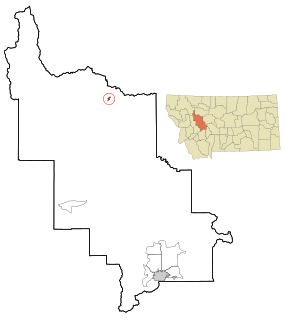
Augusta is an unincorporated community and census-designated place (CDP) in Lewis and Clark County, Montana, United States. The population was 309 at the 2010 census and rising to 316 in the 2020 census. The most accepted version in the naming of this town is after Augusta Hogan, thought to be the first child born in this town, the daughter of J. D. Hogan, an early rancher.

Lolo is a census-designated place (CDP) in Missoula County, Montana, United States. It is part of the Missoula Metropolitan Statistical Area. The population was 4,399 at the 2020 census, an increase from its population of 3,892 in 2010. It is home to Travelers' Rest State Park, a site where Lewis and Clark camped in 1805 and again in 1806.

Blue Diamond is a census-designated place (CDP) in Clark County, Nevada, United States. The population was 268 at the 2020 census.

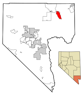
Bunkerville is a census-designated place in Clark County, Nevada, United States. The population was 1,303 at the 2010 census.

Cal-Nev-Ari is a census-designated place on U.S. Route 95 in Clark County, Nevada, United States, near the state's southernmost point. As of the 2010 census, the town had a population of 244. The town's name is a syllabic abbreviation of California, Nevada and Arizona.

Goodsprings is an unincorporated community in Clark County, Nevada, United States. The population was 229 at the 2010 census.

Indian Springs is an unincorporated town and a census-designated place located on U.S. Route 95 next to Creech Air Force Base in northwestern Clark County and southern Nevada.
Moapa Valley is an unincorporated town in Clark County, Nevada, United States. As of the 2010 census, it had a population of 6,924. The valley in which the community lies, also named Moapa Valley, is about 40 miles (64 km) long and lies roughly northwest to southeast.

Paradise is an unincorporated town and census-designated place (CDP) in Clark County, Nevada, United States, adjacent to the city of Las Vegas. It was formed on December 8, 1950. Its population was 191,238 at the 2020 census, making it the fifth most populous CDP in the United States; if it were an incorporated city, it would be the fifth largest in Nevada. As an unincorporated town, it is governed by the Clark County Commission with input from the Paradise Town Advisory Board.
Sandy Valley is an unincorporated community in the Mesquite Valley in west–central Clark County, Nevada, United States. Sandy Valley has a variant name of Sandy, Nevada. The population was 2,051 at the 2010 census. Sandy Valley is bordered on the East by the southern extension of the Spring Mountains and on the west by the California state line. Sandy Valley began in the 19th century as the five mining communities of Kingston, Sandy, Ripley, Mesquite and Platina. It is approximately forty-five miles from Las Vegas.

Searchlight is an unincorporated town and census-designated place (CDP) in Clark County, Nevada, United States, at the topographic saddle between two mountain ranges. At the 2020 census it had a population of 445.

Sunrise Manor is a census-designated place in Clark County, Nevada, United States, located on the western base of Frenchman Mountain, east of Las Vegas. The population was 205,618 at the 2020 census. If Sunrise Manor were to be incorporated, it would be one of the largest cities in Nevada. Sunrise Manor was formed in May 1957.
Whitney is an unincorporated town and census-designated place in Clark County, Nevada, United States. The population was 38,585 at the 2010 census.

Winchester is an unincorporated town and census-designated place (CDP) in Clark County, Nevada, United States that contains part of the Las Vegas Strip. It is one of a number of CDPs in the unincorporated urbanized area directly south of Las Vegas. The population was 36,403 at the 2020 census. It is governed by the Clark County Commission with advice from the Winchester Town Advisory Board. "Winchester, NV" does not appear in postal addresses; the United States Postal Service has assigned "Las Vegas, NV" as the place name for the ZIP codes containing Winchester.

Hawthorne is a census-designated place (CDP) in Mineral County, Nevada, United States. At the 2010 census, the population was 3,269, a decrease since the 2000 census, when it was 3,311. It is the county seat of Mineral County. The nearby Hawthorne Army Depot is the primary economic base of the town.
Spanish Springs is a census-designated place (CDP) in Washoe County, Nevada, United States. It is located in the northeastern part of the Reno–Sparks Metropolitan Statistical Area. The population was 15,064 at the 2010 Census.
Sun Valley is a census-designated place (CDP) in Washoe County, Nevada, United States. The population was 19,299 at the 2010 census. It is north of Reno and is part of the Reno–Sparks Metropolitan Statistical Area.


