
Las Vegas, often known simply as Vegas, is the 25th-most populous city in the United States, the most populous city in the state of Nevada, and the county seat of Clark County. The Las Vegas Valley metropolitan area is the largest within the greater Mojave Desert, and 2nd-largest in the Southwestern United States. Las Vegas is an internationally renowned major resort city, known primarily for its gambling, shopping, fine dining, entertainment, and nightlife, with most venues centered on downtown Las Vegas and more to the Las Vegas Strip just outside city limits. The Las Vegas Valley as a whole serves as the leading financial, commercial, and cultural center for Nevada.

Clark County is a county located in the U.S. state of Nevada. As of the 2020 census, the population was 2,265,461. Most of the county population resides in the Las Vegas Census County Divisions, which hold 2,196,623 people as of the 2020 Census, across 435 square miles (1,130 km2). It is by far the most populous county in Nevada, and the 11th most populous county in the United States. It covers 7% of the state's land area but holds 73% of the state's population, making Nevada the most centralized state in the United States.
Interstate 15 (I-15) is a major Interstate Highway in the Western United States, running through Southern California and the Intermountain West. I-15 begins near the Mexican border in San Diego County and stretches north to Alberta, Canada, passing through the states of California, Nevada, Arizona, Utah, Idaho, and Montana. The Interstate serves the cities of San Diego, San Bernardino, Las Vegas, Salt Lake City, Idaho Falls, and Great Falls. It also passes close to the urban areas of Los Angeles, Orange, and Riverside counties, California. The stretches of I-15 in Idaho, Utah, and Arizona have been designated as the "Veterans Memorial Highway". The southern end is at a junction with I-8 and State Route 15 (SR 15) in San Diego, and the northern end is at a connection with Alberta Highway 4 at the Sweetgrass–Coutts Border Crossing.

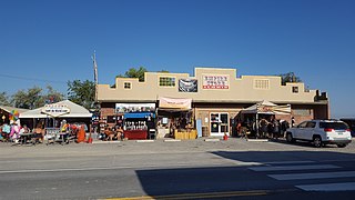
Cal-Nev-Ari is a census-designated place on U.S. Route 95 in Clark County, Nevada, United States, near the state's southernmost point. As of the 2010 census, the town had a population of 244. The town's name is a syllabic abbreviation of California, Nevada and Arizona.

Enterprise is an unincorporated town in the Las Vegas Valley in Clark County, Nevada, United States. The population was 221,831 at the 2020 U.S. census, up from 14,676 at the 2000 census. It was founded on December 17, 1996. Like other unincorporated towns in the Las Vegas Valley, it uses Las Vegas ZIP codes for addresses within its boundaries.

Henderson is a city in Clark County, Nevada, United States, about 16 miles (26 km) southeast of downtown Las Vegas. It is the 2nd most populous city in Nevada, after Las Vegas, with an estimated population of 320,189 in 2019. The city is part of the Las Vegas Valley. Henderson occupies the southeastern end of the valley, at an elevation of 1,864 feet (568 m).

Laughlin is an unincorporated community in Clark County, Nevada, United States. Laughlin lies 90 miles (140 km) south of Las Vegas, in the far southern tip of Nevada. As a resort town, it is known for its gaming and water recreation. As of the 2020 census, the population was 8,658. For statistical purposes, the United States Census Bureau has defined Laughlin as a census-designated place (CDP). It is located on the Colorado River, downstream from the Davis Dam and Lake Mohave, and directly across from the much larger Bullhead City, Arizona. The nearby communities of Bullhead City, Arizona; Needles, California; Fort Mohave, Arizona; and Mohave Valley, Arizona, bring the area's total population to about 100,000. Laughlin is also 286 miles (460 km) northeast of Los Angeles.

Mesquite is a city in Clark County, Nevada, United States adjacent to the Arizona state line and 80 miles (130 km) northeast of Las Vegas on Interstate 15. As of the 2020 census, the city had a population of 20,471. The city is located in the Virgin River valley adjacent to the Virgin Mountains in the northeastern part of the Mojave Desert. It is home to a growing retirement community, as well as several casino resorts and golf courses.

Sandy Valley is a bedroom community of Las Vegas located in west–central Clark County, Nevada, United States. It is approximately 35 miles from the southern part of Las Vegas and west Henderson, Nevada and 20 miles from the Jean exit at Interstate 15. Sandy Valley is also located 14 miles from the historic town of Goodsprings, Nevada.
Empire is an unincorporated community and census-designated place (CDP) in Washoe County, Nevada, with a population estimated at 65 (2021). Prior to the 2010 census it was part of the Gerlach–Empire census-designated place, it is now part of the Reno–Sparks Metropolitan Statistical Area. The nearest town, Nixon, is 60 miles (97 km) to the south on a reservation owned by the Pyramid Lake Paiute Tribe.

Primm is an unincorporated community in Clark County, Nevada, United States, primarily notable for its position straddling Interstate 15 at the Nevada–California border. It sits on Ivanpah Dry Lake, which extends to the north and south of town.

The Las Vegas Valley is a major metropolitan area in the southern part of the U.S. state of Nevada, and the second largest in the Southwestern United States. The state's largest urban agglomeration, the Las Vegas Metropolitan Statistical Area is coextensive since 2003 with Clark County, Nevada. The Valley is largely defined by the Las Vegas Valley landform, a 600 sq mi (1,600 km2) basin area surrounded by mountains to the north, south, east and west of the metropolitan area. The Valley is home to the three largest incorporated cities in Nevada: Las Vegas, Henderson and North Las Vegas. Eleven unincorporated towns governed by the Clark County government are part of the Las Vegas Township and constitute the largest community in the state of Nevada.
Jean is a small commercial town in Clark County, Nevada, United States, located approximately 20 miles (32 km) south of the Las Vegas hotel-casino corridor along Interstate 15, and 12 mi (19 km) north of the Nevada-California border.

Las Vegas Springs Preserve consists of 180 acres (73 ha) dedicated to nature walks and displays and is owned and operated by the Las Vegas Valley Water District. The Preserve is located approximately three miles west of downtown Las Vegas, Nevada. The Preserve is built around the original water source for Las Vegas, the Las Vegas Springs.

Terrible Herbst, or Terrible Herbst Oil Company, is an American privately held gas station company based in Paradise, Nevada, United States.
Brightline West is a proposed privately run high-speed rail route in the United States linking the Las Vegas Valley and Rancho Cucamonga in the Greater Los Angeles area through the California high desert. The line will connect with existing rail at Rancho Cucamonga station of Metrolink's San Bernardino Line, a commuter rail line in Southern California. The project is intended to provide an alternative to air and automobile travel between Southern California and Las Vegas, a popular leisure destination. Construction on the route is expected to begin in 2023 pending result from a $3.75 billion in grant application from Infrastructure Investment and Jobs Act, which is expected to be announced in October 2023, and revenue service is planned to begin in 2027.
Transportation in the Las Vegas Valley including the cities of Las Vegas, North Las Vegas and Henderson is a multi-faceted system. The street system is mostly laid out in a north-south/east-west system of roads. While most residents rely on cars, there is a network of bus routes reaching some areas of the county. The Las Vegas Valley, being the one of the largest tourist destinations in the world, has a mass transportation system which favors the Las Vegas Strip.
The following is a timeline of the history of the city of Las Vegas, Nevada, United States.

Corn Creek is an unincorporated community in Clark County, Nevada, United States. The community is located along the former Las Vegas and Tonopah Railroad where it had a station. It is approximately 7.5 miles from the Las Vegas city limits by road and is situated south of the Desert National Wildlife Refuge border and bordered to the west, south, and east with the Tule Springs Fossil Beds National Monument.

Terrible's Road House is a gas station in Jean, Nevada off Nevada State Route 161. It contains the World's Largest Chevron and is a tourist trap for people traveling from Las Vegas to California, being about 30 mi (48 km) south of the former. It has 96 pumps, 60 restroom stalls, and a 50,000 sq ft (4,600 m2) convenience store. The gas station is owned by Terrible Herbst.


