
Carson City is an independent city and the capital of the U.S. state of Nevada. As of the 2020 census, the population was 58,639, making it the sixth largest city in Nevada. The majority of the city's population lives in Eagle Valley, on the eastern edge of the Carson Range, a branch of the Sierra Nevada, about 30 miles (50 km) south of Reno. The city is named after the mountain man Kit Carson. The town began as a stopover for California-bound immigrants, but developed into a city with the Comstock Lode, a silver strike in the mountains to the northeast. The city has served as Nevada's capital since statehood in 1864; for much of its history it was a hub for the Virginia and Truckee Railroad, although the tracks were removed in 1950.

Washoe County is a county in the U.S. state of Nevada. As of the 2020 census, the population was 486,492, making it Nevada's second-most populous county. Its county seat is Reno. Washoe County is included in the Reno, NV Metropolitan Statistical Area.

Lyon County is a county in the U.S. state of Nevada. As of the 2020 census, the population was 59,235. Lyon County comprises the Fernley, NV Micropolitan Statistical Area, which is part of the Reno-Carson City-Fernley, NV Combined Statistical Area.
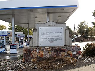
Dayton is an unincorporated community and census-designated place (CDP) in Lyon County, Nevada, United States. The population was 15,153 at the 2020 census. Dayton is the first Nevada settlement and home to the oldest hotel in Nevada.
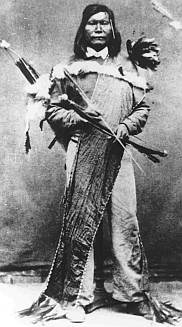
The Paiute War, also known as the Pyramid Lake War, Washoe Indian War and the Pah Ute War, was an armed conflict between Northern Paiutes allied with the Shoshone and the Bannock against settlers from the United States, supported by military forces. It took place in May 1860 in the vicinity of Pyramid Lake in the Utah Territory, now in the northwest corner of present-day Nevada. The war was preceded by a series of increasingly violent incidents, culminating in two pitched battles in which 79 Whites and 25 Indigenous people were killed. Smaller raids and skirmishes continued until a cease-fire was agreed to in August 1860; there was no treaty.

The Nevada Legislature is a bicameral body, consisting of the lower house, the Assembly, with 42 members, and the upper house, the Senate, with 21. With a total of 63 seats, the Legislature is the third-smallest bicameral state legislature in the United States, after Alaska's and Delaware's (62). The Nevada State Legislature as of 2019 is the first majority female State Legislature in the history of the United States. As of 2022, the Democratic Party controls both houses of the Nevada State Legislature. In the 2022 Nevada elections, which were a part of the midterm elections for that year, the Democratic Party obtained a supermajority in the lower house of the state legislature. As for the upper house of the state legislature, the elections provided the Democratic Party with thirteen of the twenty-one seats—amounting to a partisan composition of 61.9 percent.

The landlocked U.S. state of Nevada has a varied geography and is almost entirely within the Basin and Range Province and is broken up by many north–south mountain ranges. Most of these ranges have endorheic valleys between them.
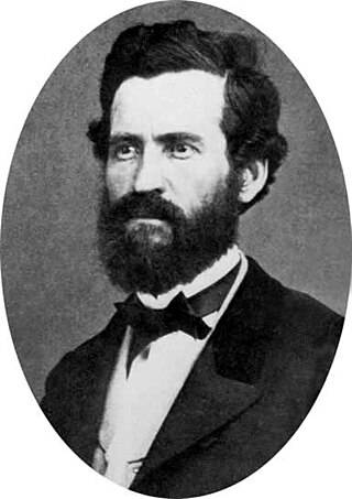
Orion Clemens was the first and only Secretary of the Nevada Territory. His younger brother Samuel Langhorne Clemens became a famous author under the pen name Mark Twain.

The following outline is provided as an overview of and topical guide to the U.S. state of Nevada:

The 3rd Regiment California Volunteer Infantry was an infantry regiment in the Union Army during the American Civil War. This regiment was organized at Stockton and at Benicia Barracks, from October 31 to December 31, 1861, to serve three years. The regiment was first commanded by Colonel Patrick Edward Connor. After the formation of the regiment at Stockton, four companies were sent to Humboldt County during the month of November, 1861. During the month of July, 1862, Colonel Connor was sent, with his regiment, to the District of Utah, in which it was on duty for the balance of its term of service.
During the American Civil War in the early 1860s, the District of Utah was a subordinate district of the U.S. Army's Department of the Pacific. The district was composed of territorial areas that later became parts of the modern U.S. states of Idaho, Nevada, and Utah.
The First Battle of Pyramid Lake in 1860 was one of the opening conflicts of the Paiute War in Nevada between the American people and the Paiute people, who had resisted the increasing numbers of migrants who traveled the California Trail through their territory, taking scarce game and water resources, as well as altercations with the Pony Express.

The Stewart Indian School (1890–1980) was an Indian school southeast of Carson City, Nevada that is noted for the masonry work of colored native stone used by student apprentices to build the vernacular-style buildings. The school, part of the Native American boarding schools project, was the only off-reservation boarding school in Nevada. Funding for the school was obtained by Nevada's first senator, William M. Stewart, and it was named in his honor when it opened on December 17, 1890. It has also been known as Stewart Institute, Carson Industrial School, and Carson Indian School.

The Department of California was an administrative department of the United States Army. The Department was created in 1858, replacing the original Department of the Pacific, and it was ended by the reorganizations of the Henry L. Stimson Plan implemented in February 1913. As with the preceding organization, headquarters were in San Francisco. Its creation was authorized by General Orders, No. 10, of the War Department, Adjutant-General's Office, September 13, 1858.
The Nevada State Museum in Carson City is one of seven Nevada State Museums operated by the Nevada Department of Tourism and Cultural Affairs. The primary building of the museum is the former Carson City Mint. The exhibits include:

Eagle Valley is the area encompassing Carson City, Nevada. The valley was first settled during the California Gold Rush of 1849. The discovery of Nevada's Comstock Lode in 1859 established the economic importance of the area, which would become the site of the Nevada State Capitol.
In the United States, an independent city is a city that is not in the territory of any county or counties and is considered a primary administrative division of its state. Independent cities are classified by the United States Census Bureau as "county equivalents" and may also have similar governmental powers to a consolidated city-county. However, in the case of a consolidated city-county, a city and a county were merged into a unified jurisdiction in which the county at least nominally exists to this day, whereas an independent city was legally separated from any county or merged with a county that simultaneously ceased to exist even in name.

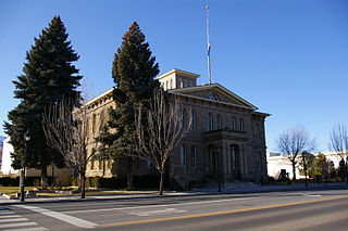
The Carson City Public Buildings, on Carson St. in Carson City, Nevada is a set of historic buildings dating back to 1920. There are three contributing buildings. The set was listed on the National Register of Historic Places in 1987. The three are the Nevada State Supreme Court Building, the Ormsby County Courthouse, and the Heroes Memorial Building, designed by Nevada premier architect Frederick J. DeLongchamps.

Alanson "Lance" Walker Nightingill was a county sheriff and the first Nevada State Controller.

