Utah Territory

Last updated

Territory of Utah
Organized incorporated territory of the United States
1850–1896
Utah territory coat of arms (illustrated, 1876).jpg
Territorial coat of arms (1876)
Utah Territory, vector image - 2011.svg
The Utah Territory upon its creation, with modern state boundaries shown for reference
Capital
Government
  Type Organized incorporated territory
Governor  
 1851–58
Brigham Young
 1858–61
Alfred Cumming
 1875–80
George W. Emery
 1880–86
Eli Houston Murray
 1886–89, 1893–96
Caleb Walton West
Legislature Utah Territorial Assembly
History 
1849
 Utah Organic Act
September 9 1850
  Colorado Territory formed
February 28, 1861
  Nevada Territory formed
March 2, 1861
  Wyoming Territory formed
July 25, 1868
  Statehood
January 4 1896
Preceded by
Succeeded by
Alleged Mormon flag 1877.svg State of Deseret
Utah Flag of Utah (1903-1913).svg

The Territory of Utah was an organized incorporated territory of the United States that existed from September 9, 1850, [2] until January 4, 1896, when the final extent of the territory was admitted to the Union as the State of Utah, [3] the 45th state. At its creation, the Territory of Utah included all of the present-day State of Utah, most of the present-day state of Nevada save for Southern Nevada (including Las Vegas), much of present-day western Colorado, and the extreme southwest corner of present-day Wyoming.

Contents

History

The territory was organized by an Organic Act of Congress in 1850, on the same day that the State of California was admitted to the Union and the New Mexico Territory was added for the southern portion of the former Mexican land. The creation of the territory was part of the Compromise of 1850 that sought to preserve the balance of power between slave and free states. With the exception of a small area around the headwaters of the Colorado River in present-day Colorado, the United States had acquired all the land of the territory from Mexico with the Treaty of Guadalupe Hidalgo of 1848. After passing the Senate, the House of Representatives voted in favor of organizing the Territory of Utah, 97–85. [4]

The creation of the Utah Territory was partially the result of the petition sent by the Mormon pioneers who had settled in the valley of the Great Salt Lake starting in 1847. The Mormons, under the leadership of Brigham Young, had petitioned Congress for entry into the Union as the State of Deseret, with its capital as Salt Lake City and with proposed borders that encompassed the entire Great Basin and the watershed of the Colorado River, including all or part of nine current U.S. states. The Mormon settlers had drafted a state constitution in 1849 and Deseret had become the de facto government in the Great Basin by the time of the creation of the Utah Territory. [5]

Following the organization of the territory, Young was inaugurated as its first governor on February 3, 1851. In the first session of the territorial legislature in September, the legislature adopted all the laws and ordinances previously enacted by the General Assembly of the State of Deseret.

During Brigham Young's governorship, he exerted considerable power over the territory. An example being that in 1873, the territory legislature gave Young the exclusive right to manufacture whiskey. [6]

Mormon governance in the territory was regarded as controversial by much of the rest of the nation, partly fed by continuing lurid newspaper depictions of the polygamy practiced by the settlers, which itself had been part of the cause of their flight from the United States to the Great Salt Lake basin after being forcibly removed from their settlements farther east.

Although the Mormons were the majority in the Great Salt Lake basin, the western area of the territory began to attract many non-Mormon settlers, especially after the discovery of silver at the Comstock Lode in 1858. In 1861, partly as a result of this, the Nevada Territory was created out of the western part of the territory. Non-Mormons also entered the easternmost part of the territory during the Pikes Peak Gold Rush, resulting in the discovery of gold at Breckenridge in Utah Territory in 1859. In 1861 a large portion of the eastern area of the territory was reorganized as part of the newly created Colorado Territory. [5]

In 1869 the territory approved and ratified women's suffrage. [7]

46 years elapsed between the organization of the territory and its admission to the Union in 1896 as the State of Utah, long after the admission of territories created after it. In contrast, the Nevada Territory, although more sparsely populated, was admitted to the Union in 1864, only three years after its formation, and Colorado was admitted in 1876.[ citation needed ]

The evolution of the Utah Territory from its creation by Congress in 1850 to 1896, when statehood was granted Utah Territory evolution animation - August 2011.gif
The evolution of the Utah Territory from its creation by Congress in 1850 to 1896, when statehood was granted

Coat of arms

The Utah state coat of arms appears on the state seal and state flag. The beehive was chosen as the emblem for the provisional State of Deseret in 1848 and represents the state's industrious and hard-working inhabitants, and the virtues of thrift and perseverance. The sego lilies on either side symbolize peace. [8] [9]

Population

Historical population
YearPop.±%
1850 11,380    
1860 40,273+253.9%
1870 86,336+114.4%
1880 146,608+69.8%
1890 210,779+43.8%
Source: 1850–1890 [10]

In 1850, 9 churches with regular services in the Utah Territory were unclassified by historian Edwin Gaustad in his Historical Atlas of Religion in America (1962), but were probably LDS churches. [11] [12] In the 1890 United States census, 25 counties in the Utah Territory reported the following population counts (after 7 reported the following counts in the 1850 United States census): [10]

1890
Rank
County1850
Population
1890
Population
1 Salt Lake 6,15758,457
2 Utah 2,02623,768
3 Weber 1,18622,723
4 Cache 15,509
5 Sanpete 36513,146
6 Summit 7,733
7 Box Elder 7,642
8 Davis 1,1346,751
9 Sevier 6,199
10 Juab 5,582
11 Emery 5,076
12 Millard 4,033
13 Washington 4,009
14 Tooele 1523,700
15 Wasatch 3,595
16 Beaver 3,340
17 Piute 2,842
18 Uintah 2,762
19 Iron 3602,683
20 Garfield 2,457
21 Morgan 1,780
22 Kane 1,685
23 Rich 1,527
24 Grand 541
25 San Juan 365
Indian reservations 4,645
Utah Territory11,380210,779

See also

Related Research Articles

<span class="mw-page-title-main">Utah</span> U.S. state

Utah is a landlocked state in the Mountain West subregion of the Western United States. It borders Colorado to its east, Wyoming to its northeast, Idaho to its north, Arizona to its south, and Nevada to its west. Utah also touches a corner of New Mexico in the southeast. Of the fifty U.S. states, Utah is the 13th-largest by area; with a population over three million, it is the 30th-most-populous and 11th-least-densely populated. Urban development is mostly concentrated in two areas: the Wasatch Front in the north-central part of the state, which is home to roughly two-thirds of the population and includes the capital city, Salt Lake City; and Washington County in the southwest, with more than 180,000 residents. Most of the western half of Utah lies in the Great Basin.

<span class="mw-page-title-main">Tooele County, Utah</span> County in Utah, United States

Tooele County is a county in the U.S. state of Utah. As of the 2020 United States Census, the population was 72,698. Its county seat and largest city is Tooele. The county was created in 1850 and organized the following year.

<span class="mw-page-title-main">New Mexico Territory</span> Territory of the United States of America (1850–1912)

The Territory of New Mexico was an organized incorporated territory of the United States from September 9, 1850, until January 6, 1912. It was created from the U.S. provisional government of New Mexico, as a result of Nuevo México becoming part of the American frontier after the Treaty of Guadalupe Hidalgo. It existed with varying boundaries until the territory was admitted to the Union as the U.S. state of New Mexico. This jurisdiction was an organized, incorporated territory of the US for nearly 62 years, the longest period of any territory in the contiguous United States.

<span class="mw-page-title-main">Nevada Territory</span> Former organized incorporated territory of the U.S.

The Territory of Nevada (N.T.) was an organized incorporated territory of the United States that existed from March 2, 1861, until October 31, 1864, when it was admitted to the Union as the State of Nevada.

<span class="mw-page-title-main">State of Deseret</span> Provisional state founded by Mormons, 1848–1850

The State of Deseret was a proposed state of the United States, promoted by leaders of the Church of Jesus Christ of Latter-day Saints who had founded settlements in what is today the state of Utah. A provisional state government operated for nearly two years in 1849–50, but was never recognized by the United States government. The name Deseret derives from the word for "honeybee" in the Book of Mormon.

<span class="mw-page-title-main">Mormon pioneers</span> Members of the Latter-day Saints church who moved to the western U.S. in the 1840s

The Mormon pioneers were members of the Church of Jesus Christ of Latter-day Saints, also known as Latter-day Saints, who migrated beginning in the mid-1840s until the late-1860s across the United States from the Midwest to the Salt Lake Valley in what is today the U.S. state of Utah. At the time of the planning of the exodus in 1846, the territory comprising present-day Utah was part of the Republic of Mexico, with which the U.S. soon went to war over a border dispute left unresolved after the annexation of Texas. The Salt Lake Valley became American territory as a result of the Treaty of Guadalupe Hidalgo, which ended the war.

<span class="mw-page-title-main">John Williams Gunnison</span> 19th-century American explorer

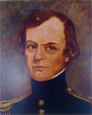
John Williams Gunnison was an American military officer and explorer.

<span class="mw-page-title-main">United States congressional delegations from Utah</span>

Since Utah became a U.S. state in 1896, it has sent congressional delegations to the United States Senate and United States House of Representatives. Each state elects two senators to serve for six years. Before the Seventeenth Amendment in 1913, senators were elected by the Utah State Legislature. Members of the House of Representatives are elected to two-year terms, one from each of Utah's four congressional districts. Before becoming a state, the Territory of Utah elected a non-voting delegate at-large to Congress from 1850 to 1896.

<span class="mw-page-title-main">Mormon corridor</span> Areas of the western US settled by the LDS Church

The Mormon corridor are the areas of western North America that were settled between 1850 and approximately 1890 by members of the Church of Jesus Christ of Latter-day Saints, who are commonly called "Mormons".

<span class="mw-page-title-main">History of Utah</span>

The History of Utah is an examination of the human history and social activity within the state of Utah located in the western United States.

<span class="mw-page-title-main">John R. Park</span>

John Rockey Park was a prominent educator in the Territory and State of Utah in the late 19th century, and in many ways was the intellectual father of the University of Utah.

<span class="mw-page-title-main">Index of Utah-related articles</span>

The following is an alphabetical list of articles related to the U.S. state of Utah.

<span class="mw-page-title-main">Utah Territory in the American Civil War</span>

The Utah Territory during the American Civil War was far from the main operational theaters of war, but still played a role in the disposition of the United States Army, drawing manpower away from the volunteer forces and providing its share of administrative headaches for the Lincoln Administration. Although no battles were fought in the territory, the withdrawal of Union forces at the beginning of the war allowed the Native American tribes to start raiding the trails passing through Utah. As a result, units from California and Utah were assigned to protect against these raids. Mineral deposits found in Utah by California soldiers encouraged the immigration of non-Mormon settlers into Utah.

<span class="mw-page-title-main">Outline of Utah</span> Overview of and topical guide to Utah

The following outline is provided as an overview of and topical guide to Utah:

<span class="mw-page-title-main">John Sharp (Mormon)</span>

John Sharp was a 19th-century leader in the Church of Jesus Christ of Latter-day Saints in Utah Territory. Sharp was the LDS Church's representative in negotiations regarding the construction of the First transcontinental railroad through Utah Territory. He represented the LDS Church and its president, Brigham Young, at the driving of the final golden spike of the railroad on 10 May 1869 at Promontory Summit, Utah Territory.

Enoch Reese was an early leader in the Church of Jesus Christ of Latter-day Saints, a member of the Utah Territorial Legislature, and an early settler of Nevada.

In the history of the American frontier, pioneers built overland trails throughout the 19th century, especially between 1829 and 1870, as an alternative to sea and railroad transport. These immigrants began to settle much of North America west of the Great Plains as part of the mass overland migrations of the mid-19th century. Settlers emigrating from the eastern United States did so with various motives, among them religious persecution and economic incentives, to move from their homes to destinations further west via routes such as the Oregon, California, and Mormon Trails. After the end of the Mexican–American War in 1849, vast new American conquests again encouraged mass immigration. Legislation like the Donation Land Claim Act and significant events like the California Gold Rush further encouraged settlers to travel overland to the west.

<span class="mw-page-title-main">Eagle Valley (Nevada)</span>

Eagle Valley is the area encompassing Carson City, Nevada. The valley was first settled during the California Gold Rush of 1849. The discovery of Nevada's Comstock Lode in 1859 established the economic importance of the area, which would become the site of the Nevada State Capitol.

The Deseret Telegraph Company was a telegraphy company headquartered in Salt Lake City, Utah, United States. The company was organized in 1867 to direct operation of the recently completed Deseret Telegraph Line; its largest stakeholder was the Church of Jesus Christ of Latter-day Saints. The Deseret line ran north and south through the Utah Territory, connecting the numerous settlements with Salt Lake City and the First Transcontinental Telegraph. The company was dissolved in 1900 when its assets, including the Deseret line, were sold to the Western Union Telegraph Company.

Rio Virgen County is a former county in the U.S. state of Utah. It was established by the Territory of Utah in February 1869.

References

  1. "FlagTerritorial.jpg". pioneer.utah.gov. Archived from the original on June 23, 2012. Retrieved May 6, 2021.
  2. 9  Stat.   453
  3. "Utah". World Statesmen. Retrieved July 20, 2015.
  4. "Friday, September 6, 1850". The National Era (Washington, D.C.). Newspapers.com. September 12, 1850. p. 3.
  5. 1 2 Alford, Kenneth L. (2017). Utah and the American Civil War: The Written Record. University of Oklahoma Press. p. 801. ISBN   978-0-8061-5916-4.
  6. Vance, Del (2008). Beer in the Beehive (2 ed.). Salt Lake City: Dream Garden Press. p. 32.
  7. Lemay, Kate Clarke; Goodier, Susan; Tetrault, Lisa; Jones, Martha (2019). Votes for Women: A Portrait of Persistence. Princeton University Press. p. 270. ISBN   9780691191171.
  8. Utah State Coat of Arms State Symbols USA.
  9. Utah State Emblem: Beehive eReferenceDesk.
  10. 1 2 Forstall, Richard L. (ed.). Population of the States and Counties of the United States: 1790–1990 (PDF) (Report). United States Census Bureau. pp. 162–163. Retrieved May 18, 2020.
  11. Selcer, Richard F. (2006). Balkin, Richard (ed.). Civil War America: 1850 to 1875. New York: Facts on File. p. 143. ISBN   978-0816038671.
  12. Gaustad, Edwin (1962). Historical Atlas of Religion in America. New York: Harper & Row.

Further reading

39°50′N113°30′W / 39.833°N 113.500°W / 39.833; -113.500