The establishment of the Southwest Territory followed a series of efforts by North Carolina's trans-Appalachian residents to form a separate political entity, initially with the Watauga Association, and later with the failed State of Franklin. North Carolina ceded these lands in April 1790 as payment of obligations owed to the federal government. The territory's residents welcomed the cession, believing the federal government would provide better protection from Indian hostilities. The federal government paid relatively little attention to the territory, however, increasing its residents' desire for full statehood.
During the colonial period, land that would become the Southwest Territory was part of North Carolina's land patent. The Blue Ridge Mountains, which rise along the modern Tennessee-North Carolina border, hindered North Carolina from pursuing any lasting interest in the territory. Initially trade, political interest, and settlement came mostly from Virginia and South Carolina, though refugees from the Regulator War began arriving from North Carolina in the early 1770s.
The Watauga Association was a semi-autonomous government created in 1772 by frontier settlers living along the Watauga River in what is present day Elizabethton, Tennessee. The colony was established on Cherokee-owned land in which the Watauga and Nolichucky settlers had negotiated a 10-year lease directly with the Indians. Fort Watauga was established on the Watauga River at Sycamore Shoals as a trade center of the settlements.
Both North Carolina and Virginia considered the trans-Appalachian settlements illegal, and refused to annex them. Nevertheless, at the onset of the American War for Independence in 1776, the settlers, who vigorously supported the Patriot cause, organized themselves into the "Washington District" and formed a committee of safety to govern it. In July 1776, Dragging Canoe and the faction of the Cherokee opposed to the Transylvania Purchase (later called the Chickamaugas) aligned with the British and launched an invasion of the Watauga settlements, targeting Fort Watauga at modern Elizabethton and Eaton's Station near modern Kingsport. After the settlers thwarted the attacks, North Carolina agreed to annex the settlements as the Washington District.
In 1784, North Carolina ceded control of the Overmountain settlements following a hotly contested vote. The cession was rescinded later that year, but not before some of the settlers had organized the State of Franklin, which sought statehood. John Sevier was named governor and the area began operating as an independent state not recognized by the Congress of the Confederation. Many Overmountain settlers, led by John Tipton, remained loyal to North Carolina, and frequently quarreled with the Franklinites. Following Tipton's defeat of Sevier at the "Battle of Franklin" in early 1788, the State of Franklin movement declined. The Franklinites had agreed to rejoin North Carolina by early 1789.
Territory formation
North Carolina ratified the United States Constitution on November 21, 1789.[7] On December 22, the state legislature voted to cede the Overmountain settlements as payment of its obligations to the new federal government.[8] Congress accepted the cession during its first session on April 2, 1790, when it passed "An Act to Accept a Cession of the Claims of the State of North Carolina to a Certain District of Western Territory".[9] On May 26, 1790, Congress passed an act organizing the new cession as the "Territory of the United States South of the River Ohio", which consisted of modern Tennessee, with the exception of later minor boundary changes.[9] However, most of the new territory was under Indian control, with territorial administration initially covering two unconnected areas—the Washington District in what is now northeast Tennessee, and the Mero District around Nashville.[1] The act also merged the office of territorial governor with the office of Superintendent of Indian Affairs for the Southern Department.[8]
Low's map, "The State of Kentucky and adjoining Territories". The Southwest Territory did not yet include West Tennessee, which was still under control of Indians. From Low's Encyclopaedia
The new territory was essentially governed under the same provisions as the Northwest Ordinance, a 1787 act enacted for the creation of the Northwest Territory north of the Ohio River. The Northwest Ordinance's provision outlawing slavery was not applied to the Southwest Territory, however. Along with rules of governance, the Ordinance outlined steps a territory could take to gain admission to the Union. The first step involved the organization of a territorial government. The next step, which would take place when the territory had at least 5,000 adult males, was to organize a territorial legislature, with a popularly elected lower chamber and an upper chamber appointed by the president. The final step, which would take place when the territory had a population of at least 60,000, was to write a state constitution and elect a state government, at which time the territory would be admitted to the Union.[1]
Several candidates were put forth for governor of the new territory. William Blount (1749–1800), a Constitutional Convention delegate and former state legislator who had championed the causes of western settlers, was supported by key North Carolina politicians such as Hugh Williamson, Timothy Bloodworth, John B. Ashe and Benjamin Hawkins. Blount, an aggressive land speculator, had extensive land holdings in the new territory. Virginia's Patrick Henry called for his friend, General Joseph Martin, to be appointed governor. A small group of ex-Franklinites convened in Greeneville to push for the appointment of John Sevier.[9]
On June 8, 1790, President George Washington chose Blount as the territory's new governor. He also appointed Daniel Smith (1748–1818) the territory's Secretary, and named two of the territory's three judges, John McNairy and David Campbell (Joseph Anderson would eventually be chosen as the third judge). John Sevier was appointed brigadier general of the Washington District militia, and James Robertson was appointed brigadier general of the Mero District militia.[1]
In September 1790, Blount visited Washington at Mount Vernon, and was sworn in by Supreme Court justice James Iredell. He then moved to the new territory, where he set up a temporary capital at Rocky Mount, the home of William Cobb in Sullivan County. He recruited North Carolina publisher George Roulstone to establish a newspaper, the Knoxville Gazette (initially published at Rogersville). He spent most of October and November issuing appointments to lower-level administrative and militia positions. In December, he made the dangerous trip across Indian territory to the Mero District, where he likewise issued appointments, before returning to Rocky Mount by the end of the year.[9]
Blount initially wanted the permanent territorial capital to be located at the confluence of the Clinch and Tennessee rivers (in the vicinity of modern Kingston), where he had extensive land claims, but was unable to convince the Cherokee to relinquish ownership of these lands. He therefore chose James White's Fort, an outpost located further upstream along the Tennessee. In 1791, White's son-in-law, Charles McClung, platted the new city, and lots were sold in October of that year. Blount named the new city "Knoxville" after his superior in the War Department, Henry Knox.[10]
Howard Pyle's depiction of a scout warning the residents of Knoxville of an approaching hostile Indian force in 1793
Residents of the Southwest Territory initially welcomed federal control, believing the federal government would provide better protection from hostile Indians than North Carolina's distant government to the east. However, the Federal government was already more focused on critical affairs in the old Northwest Territory. Most of the land in the "Old Southwest" was still either Indian territory or had already been claimed by speculators or settlers, and thus there was little money to be made from land sales.[1] President Washington issued a proclamation forbidding the violation of the Treaty of Hopewell (which had set Indian boundaries), and Secretary of War Knox frequently accused settlers of illegally encroaching on Indian lands.[9] Blount was consistently torn between placating angry frontiersmen and appeasing his superiors in the Federal government.[1]
In the Summer of 1791, Blount negotiated the Treaty of Holston with the Cherokee at the future site of Knoxville. The Treaty brought lands south of the French Broad River and east of the divide between Little River and the Little Tennessee River (essentially modern Cocke, Sevier and Blount counties) under U.S. control, and guaranteed the Territory use of a road between the Washington and Mero districts, as well as the Tennessee River.[1] The following year, Blount negotiated an agreement clarifying land boundaries with the Chickasaw, who controlled what is now West Tennessee.[1]
In spite of these agreements, continued encroachment by settlers onto Indian lands prompted reprisals, which primarily came from hostile Chickamauga Cherokee and Creek Indians. The Spanish, who controlled Florida along the Gulf of Mexico coast and still disputed the southern borders of the United States, fifteen years after the end of the Revolutionary War, encouraged and armed the southern tribes.[1] These attacks persisted throughout 1792 and 1793, with the Mero settlements bearing the brunt of the hostilities. Ziegler's Station near modern Hendersonville was destroyed, and Mero defenders had to rally to thwart a large invasion at Buchanan's Station near Nashville. In spite of growing impatience from frontiersmen, Secretary of War Knox refused to authorize an invasion of Indian territory.[1]
In September 1793, while Blount was away in Philadelphia, a large group of Cherokee invaders overran Cavet's Station west of Knoxville, and was planning to march on Knoxville before the invading force dissolved due to infighting among chiefs.[1] Territorial Secretary Daniel Smith, who was Acting Governor in Blount's absence, summoned the militia and ordered an invasion of Cherokee territory. Militia General Sevier led the militia south and destroyed several Chickamauga villages. While Blount supported Smith's decision,[8] the invasion angered Knox, who refused to issue pay for the militiamen.[1] In September 1794, Robertson, without authorization from Knox, dispatched a mounted American force under James Ore which destroyed the Chickamauga towns of Nickajack and Running Water. Robertson resigned as brigadier general shortly afterward.[1]
The defeat of northern tribes at the Battle of Fallen Timbers in August 1794, the destruction of Nickajack and Running Water, and the resolving of boundary disputes between the United States and Spain led to a decline in hostile Indian attacks.[1] In November 1794, Blount negotiated an end to the Cherokee–American wars at the Tellico Blockhouse, a federal outpost south of Knoxville.[12]
Indian land cessions in what is now Tennessee (Charles C. Royce, 1899)
Statehood
Secretary Daniel Smith's "Map of the Tennassee State" (1796)
A census in the summer of 1791 showed the territory's population to be 35,691.[1] There were 6,271 free adult white males, more than the 5,000 needed for the territory to organize a legislature.[1] Blount, however, waited until 1793 to call for elections. Members of the territorial House of Representatives (the lower chamber of the legislature) were elected in December 1793, and the first House session convened on February 24, 1794. The representatives nominated ten individuals for appointment to the territorial council (the legislature's upper chamber), five of whom—Griffith Rutherford, John Sevier, James Winchester, Stockley Donelson and Parmenas Taylor—were eventually appointed by President Washington.[8] Rutherford was chosen as the council's president.[1]
The assembly first convened on August 26, 1794, and called for immediate steps to be taken to achieve full statehood. The assembly appointed Dr. James White (not to be confused with Knoxville's founder) as its non-voting representative in Congress, making the Southwest Territory one of the first U.S. territories to make use of this power.[1] A special session of the assembly on June 29, 1795, called for a census to be taken the following month to determine if the territory's population had reached the 60,000 threshold required for statehood. The census revealed a population of 77,262 inhabitants.[1]
After the census, the territory moved swiftly to form a state government. In December 1795, counties elected delegates for the state constitutional convention. This convention met in Knoxville in January 1796, and drafted a new state constitution. The name "Tennessee", which had been in common use since 1793 when Secretary Smith published his "Short Description of the Tennassee Government", was chosen as the new name for the state.[1]
The Northwest Ordinance was vague on the final steps to be taken for a state to be fully admitted to the Union, so Tennessee's leaders proceeded to organize a state government. John Sevier was elected governor, the first Tennessee General Assembly convened in March 1796, and Blount notified the Secretary of State, Timothy Pickering, that the territorial government had been terminated.[1] A copy of the state constitution was delivered to Pickering by future governor Joseph McMinn.[8] Blount and William Cocke were chosen as the state's U.S. Senators, and Andrew Jackson was elected the state's representative. As the Southwest Territory was the first federal territory to petition to join the Union, there was confusion in Congress about how to proceed. Nonetheless, Tennessee was admitted to the Union on June 1, 1796, as the 16th state.[8]
The Southwest Territory was governed under an act of Congress, "An Act for the Government of the Territory of the United States, South of the River Ohio" (Southwest Ordinance), passed May 26, 1790.[9] This act essentially mirrored the earlier Northwest Ordinance, the key difference being over slavery, which was prohibited by the Northwest Ordinance, but not the Southwest Ordinance.[8] Both ordinances provided for freedom of religion and the sanctity of contracts, barred legal primogeniture, and encouraged the establishment of schools and respect for the liberty of the Indians.[9]
The supreme power in the territory rested in the governor, who was appointed by the President of the United States. He was assisted by the Secretary, also appointed by the President. Legislative powers rested in a bicameral territorial assembly consisting of the House of Representatives (lower chamber) and the Territorial Council (upper chamber). Representatives were popularly elected, whereas councilors were appointed by the President. Judicial power rested in three judges appointed by the President. Brigadier generals of the territorial militia were also appointed by the President. Lower administrative, judicial and military officers were appointed by the governor.[9]
Executive
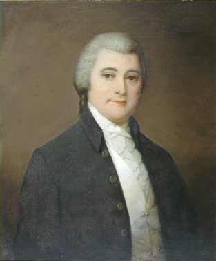
The Governor of the Southwest Territory had supreme authority in the territory. The governor could decree ordinances, propose and enact new laws, create towns and counties, and license lawyers. Though the territorial assembly held legislative powers, the governor held veto power over all proposed laws.[9] The governor was responsible for appointing the lower territorial administrative officers, including attorneys general, justices of the peace, registers, and court clerks. He recommended candidates for brigadier general to the President, and appointed lower militia officers. The governor also served as the Superintendent of Indian Affairs for the Southern Department, the federal government's chief diplomat to the Southern tribes. To serve as governor, an individual had to own at least 1,000 acres (400ha) of land in the territory.[9]William Blount (1749–1800) served as Governor of the Southwest Territory throughout the territory's existence.
The Secretary of the Southwest Territory was the official record-keeper of the territory. The Secretary also served as acting governor if the governor was absent or incapacitated. To serve as Secretary, an individual had to own at least 500 acres (200ha) of land in the territory.[9]Daniel Smith (1748–1818) served as Secretary throughout the territory's existence.
Legislature
The Southwest Territory in 1790
Legislative power in the Southwest Territory initially rested with the governor, who consulted with the three territorial judges on new laws. After the territory's population of white males reached 5,000, the territory could form a legislative assembly (the power to summon the assembly rested with the governor). The assembly consisted of an upper chamber, the Territorial Council (the role of which was similar to that of a state senate), and a lower chamber, the House of Representatives. While the assembly could propose new laws, the governor could still veto any bill. To serve on the council, an individual had to own at least 500 acres (200ha) of land in the territory.[9]
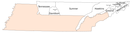
The territorial House of Representatives consisted of thirteen popularly elected members. These members elected a speaker from their own ranks. The House first convened at Knoxville on February 24, 1794. Its members were John Tipton (Washington), George Rutledge (Sullivan), Joseph Hardin (Greene), William Cocke (Hawkins), Joseph McMinn (Hawkins), Alexander Kelly (Knox), John Beard (Knox), Samuel Wear (Jefferson), George Doharty (Jefferson), David Wilson (Sumner), Dr. James White (Davidson) and James Ford (Tennessee County).[14] Wilson, of Sumner County, served as Speaker from 1794 to 1795. Hardin, of Greene, served as Speaker from 1795 to 1796.[13] Hopkins Lacy was elected clerk.[14]
Members of the territorial council were appointed by the President from a list of candidates submitted by the territorial House of Representatives. At its first session in February 1794, the House submitted ten candidates for the council: James Winchester, William Fort, Stockley Donelson, Richard Gammon, David Russell, John Sevier, Adam Meek, John Adair, Griffith Rutherford and Parmenas Taylor. From this list, President Washington appointed Winchester, Donelson, Sevier, Rutherford and Taylor.[14] Rutherford was chosen as council president (a role similar to speaker).[1]
The Northwest Ordinance allowed a territory's assembly to elect a representative to the United States Congress. This representative could consult with congressmen on legislation, but could not vote. In 1794, the Southwest Territory's assembly chose Dr. James White as its non-voting representative to Congress. The Southwest Territory was the first U.S. territory to exercise this power, and White's efforts in Congress set a precedent for future territorial delegates.[1]
Judiciary
The territory's supreme judicial power rested in three judges, each appointed by the President. The governor appointed court clerks, attorneys general and lower judicial offices, as well as justices of the peace. Along with their judicial powers, the judges could consult with the governor on new legislation, though the governor held final veto power over any proposed laws. To serve as a judge, an individual had to own at least 500 acres (200ha) of land in the territory.[9] The judges appointed by President Washington in 1790 were John McNairy (1762–1837), David Campbell (1750–1812), and Joseph Anderson (1757–1837).[1] Blount appointed Francis Alexander Ramsey clerk of the Washington District's superior court of law, Andrew Russell clerk of the Washington District's court of equity, David Allison clerk of Mero's superior court of law, and Joseph Sitgreaves clerk of Mero's court of equity.[9]
The courts of the Southwest Territory were generally more highly regarded than other branches of government.[15] Frontiersmen had for years relied on county courts to settle disputes, and upon being appointed governor, Blount left the existing county courts largely intact. These courts generally followed old North Carolina laws when rendering decisions, relying heavily on James Iredell's Revisal of the Laws of North Carolina (1791).[15] Along with hearing criminal and civil cases, courts were responsible for licensing ferries, regulating taverns, and designating public gristmills. Courts occasionally rendered financial assistance for internal improvements and relief for the destitute.[15] County sheriffs were responsible for collecting taxes.[15]
Lawyers were licensed by the governor to practice in the territory's courts. Notable individuals licensed to practice in the territory included future president Andrew Jackson,[1] future governor Archibald Roane, future congressman John Rhea,[16] and Blount's younger half-brother, future governor Willie Blount.[17] Jackson served as a district attorney for the territory.[18]
Land details
The Washington District, as it appeared on Abraham Bradley's 1796 postal map
The Southwest Territory covered 43,000 square miles (110,000km2),[2] consisting of what is now Tennessee, with the exception of a few minor boundary changes resulting from later surveys.[1] To its north was Virginia's District of Kentucky, which became the 15th U.S. state in 1792.[2] The lands to the territory's south were at the time either still claimed by Georgia, or disputed with Spain, but subsequently consolidated into the Mississippi Territory.
At its creation in 1790, the Southwest Territory's administration oversaw two unconnected districts—the Washington District in the northeast, and the Mero District in the area around and north of Nashville. The remainder of the territory remained under Indian control, with the Cherokee being the dominant tribe in the east, and the Chickasaw controlling the western part of the territory. Other important tribes included the Creeks and Choctaw.[2]
The Mero District, as it appeared on Bradley's 1796 postal map
The Washington District initially included lands north of the French Broad River and northeast of the confluence of the Clinch and Tennessee rivers (near modern Kingston). The 1791 Treaty of Holston pushed the boundary south of the French Broad and southeast to the divide between Little River and the Little Tennessee River (in what is now southern Blount County). The Washington District originally included Washington, Sullivan, Greene and Hawkins counties.[1]Knox and Jefferson were created by Governor Blount in 1792.[15] In 1793, Blount organized these two new counties into a separate district, called the "Hamilton District".[19]Blount and Sevier counties would be added to this new district during territorial administration.[15]
The Mero District included the lands around Nashville and along the Cumberland River, north to the modern Kentucky border. It included three counties—Davidson, Sumner and Tennessee.[1] The Mero and Washington districts were connected by a road, generally known as Avery's Trace, which traversed Indian lands.[20]
The population of the Southwest Territory in 1791 was 35,691.[2] This included 3,417 slaves and 361 free persons of color. The population of the Washington District was 28,649, while the population of Mero was 7,042.[1] The territory's 1795 census showed a total population of 77,262 inhabitants, including 10,613 slaves and 973 free persons of color. The population of the Washington and Hamilton districts was 65,338, and the population of Mero was 11,924.[1]
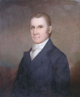
Willie Blount was an American politician who served as the third Governor of Tennessee from 1809 to 1815. Blount's efforts to raise funds and soldiers during the War of 1812 earned Tennessee the nickname, "Volunteer State." He was the younger half-brother of Southwest Territory governor, William Blount. He was a member of the Democratic-Republican Party.
William Blount was an American politician, landowner and Founding Father who was one of the signers of the Constitution of the United States. He was a member of the North Carolina delegation at the Constitutional Convention of 1787 and led the efforts for North Carolina to ratify the Constitution in 1789 at the Fayetteville Convention. He then served as the only governor of the Southwest Territory and played a leading role in helping the territory gain admission to the union as the state of Tennessee. He was selected as one of Tennessee's initial United States Senators in 1796, serving until he was expelled for treason in 1797.
The State of Franklin was an unrecognized proposed state located in present-day East Tennessee, in the United States. Franklin was created in 1784 from part of the territory west of the Appalachian Mountains that had been offered by North Carolina as a cession to Congress to help pay off debts related to the American War for Independence. It was founded with the intent of becoming the 14th state of the new United States.
John Sevier was an American soldier, frontiersman, and politician, and one of the founding fathers of the State of Tennessee. A member of the Democratic-Republican Party, he played a leading role in Tennessee's pre-statehood period, both militarily and politically, and he was elected the state's first governor in 1796. He served as a colonel of the Washington District Regiment in the Battle of Kings Mountain in 1780, and he commanded the frontier militia in dozens of battles against the Cherokee in the 1780s and 1790s.
James Robertson was an American explorer, soldier and Indian agent, and one of the founding fathers of what became the State of Tennessee. An early companion of explorer Daniel Boone, Robertson helped establish the Watauga Association in the early 1770s, and to defend Fort Watauga from an attack by Cherokee in 1776. In 1779, he co-founded what is now Nashville, and was instrumental in the settlement of Middle Tennessee. He served as a brigadier general in the Southwest Territory militia in the early 1790s, and as an Indian Commissioner in later life.
James White was an American pioneer and soldier who founded Knoxville, Tennessee, in the early 1790s. Born in Rowan County, North Carolina, White served as a captain in the county's militia during the American Revolutionary War. In 1783, he led an expedition into the upper Tennessee Valley, where he discovered the future site of Knoxville. White served in various official capacities with the failed State of Franklin (1784–1788) before building James White's Fort in 1786. The fort was chosen as the capital of the Southwest Territory in 1790, and White donated the land for a permanent city, Knoxville, in 1791. He represented Knox County at Tennessee's constitutional convention in 1796. During the Creek War (1813), White served as a brigadier general in the Tennessee militia.
The Overmountain Men were American frontiersmen from west of the Blue Ridge Mountains which are the leading edge of the Appalachian Mountains, who took part in the American Revolutionary War. While they were present at multiple engagements in the war's southern campaign, they are best known for their role in the American victory at the Battle of Kings Mountain in 1780. The term "overmountain" arose because their settlements were west of, or "over", the Blue Ridge, which was the primary geographical boundary dividing several of the 13 American states from the Native American lands to the west. The Overmountain Men hailed from parts of Virginia, North Carolina, and what is now Tennessee and Kentucky.
The Watauga Association was a semi-autonomous government created in 1772 by frontier settlers living along the Watauga River in what is now Elizabethton, Tennessee. Although it lasted only a few years, the Watauga Association provided a basis for what later developed into the state of Tennessee and likely influenced other western frontier governments in the trans-Appalachian region. North Carolina annexed the Watauga settlement area, by then known as the Washington District, in November 1776. Within a year, the area was placed under a county government, becoming Washington County, North Carolina, in November 1777. This area covers the present day Washington County, Carter County, and other areas now located in the northeast part of the state of Tennessee.
The Sycamore Shoals of the Watauga River, usually shortened to Sycamore Shoals, is a rocky stretch of river rapids along the Watauga River in Elizabethton, Tennessee. Archeological excavations have found Native Americans lived near the shoals since prehistoric times, and Cherokees gathered there. As Europeans began settling the Trans-Appalachian frontier, the shoals proved strategic militarily, as well as shaped the economies of Tennessee and Kentucky. Today, the shoals are protected as a National Historic Landmark and are maintained as part of Sycamore Shoals State Historic Park.
The Cherokee–American wars, also known as the Chickamauga Wars, were a series of raids, campaigns, ambushes, minor skirmishes, and several full-scale frontier battles in the Old Southwest from 1776 to 1794 between the Cherokee and American settlers on the frontier. Most of the events took place in the Upper South region. While the fighting stretched across the entire period, there were extended periods with little or no action.
The Blount Mansion, also known as William Blount Mansion, located at 200 West Hill Avenue in downtown Knoxville, Tennessee, was the home of the only territorial governor of the Southwest Territory, William Blount (1749–1800). Blount, a Founding Father of the United States, a signer of the United States Constitution, and a U.S. Senator from Tennessee, lived on the property with his family and ten African-American slaves. The mansion served as the de facto capitol of the Southwest Territory. In 1796, much of the Tennessee Constitution was drafted in Governor Blount's office at the mansion. Tennessee state historian John Trotwood Moore once called Blount Mansion "the most important historical spot in Tennessee."
The Tellico Blockhouse was an early American outpost located along the Little Tennessee River in what developed as Vonore, Monroe County, Tennessee. Completed in 1794, the blockhouse was a US military outpost that operated until 1807; the garrison was intended to keep peace between the nearby Overhill Cherokee towns and encroaching early Euro-American pioneers in the area in the wake of the Cherokee–American wars.
Overhill Cherokee was the term for the Cherokee people located in their historic settlements in what is now the U.S. state of Tennessee in the Southeastern United States, on the western side of the Appalachian Mountains. This name was used by 18th-century European traders and explorers from British colonies along the Atlantic coast, as they had to cross the mountains to reach these settlements.
The Battle of Hightower in 1793 was part of the Cherokee–American wars, in which the Cherokee sought to defend tribal territory from increasing settlement by the citizens of the new United States. This particular battle took place at the Cherokee village of High Town (Itawayi), overlooking downtown Rome in present-day Floyd County, Georgia, resulting in the defeat of the Cherokee by a force led by John Sevier, future Governor of Tennessee.
John Watts, also known as Young Tassel, was one of the leaders of the Chickamauga Cherokee during the Cherokee–American wars. Watts became particularly active in the fighting after frontiersmen murdered his uncle, Old Tassel Carpenter (1708–1788), in 1788, while he traveled with Cherokee delegates to a peace conference.
Robert "Bob" Benge, also known as Captain Benge, was a Cherokee leader in the Upper Towns, in present-day far Southwest Virginia during the Cherokee–American wars (1783–1794).
The Washington District of North Carolina was in a remote area west of the Appalachian Mountains, officially existing for only a short period, although it had been self-proclaimed and functioning as an independent governing entity since the spring of 1775. The district was the bureaucratic successor to the Watauga Association, a group of Virginian settlers that colonized the area in 1769, originally believing themselves to be in trans-Appalachian Virginia territory. When the settlement's application to be united with Virginia was denied, they asked North Carolina to annex the settlement, which occurred in November, 1776.
John Tipton was an American frontiersman and statesman who was active in the early development of the state of Tennessee. He is best remembered for leading the opposition to the State of Franklin movement in the 1780s, as well as for his rivalry with Franklinite leader John Sevier. He served in the legislatures of Virginia, North Carolina, the Southwest Territory, and Tennessee, and was a delegate to Tennessee's 1796 constitutional convention. Tipton's homestead still stands and is managed as the Tipton-Haynes State Historic Site.
Samuel Wear was an American War of Independence soldier who fought at the Battle of Kings Mountain. He was one of the early inhabitants of, and a founder of, the "Lost State of Franklin". He later helped draft the Constitution of the State of Tennessee.
The following is a timeline of the history of the US state of Tennessee.
1 2 3 4 5 6 7 Walter T. Durham, "The Southwest Territory: Progression to Statehood", Journal of East Tennessee History, Vol. 62 (1990), pp. 3–17.
1 2 3 4 5 6 7 8 9 10 11 12 13 14 Walter T. Durham, "The Territory of the United States South of the River Ohio", Before Tennessee: The Southwest Territory, 1790–1796 (Rocky Mount Historical Association, 1990), pp. 31–46.
↑ Stanley Folmsbee and Lucile Deaderick, "The Founding of Knoxville", East Tennessee Historical Society Publications, Vol. 13 (1941), pp. 3–20.
1 2 3 William Robertson Garrett and Albert Virgil Goodpasture, History of Tennessee (Brandon Printing Company, 1903), p. 109.
1 2 3 4 5 6 Michael Toomey, "'Doing Justice to Suitors': The Role of County Courts in the Southwest Territory", Journal of East Tennessee History, Vol. 62 (1990), pp. 33–53.
This page is based on this Wikipedia article Text is available under the CC BY-SA 4.0 license; additional terms may apply. Images, videos and audio are available under their respective licenses.