
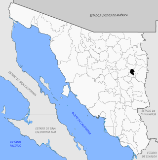
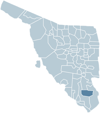
Moctezuma is a municipio (municipality) of the Mexican state of Sonora, located in the state's central region. It is also the name of its largest settlement and cabecera municipal (municipal seat).
Moctezuma is a municipio (municipality) of the Mexican state of Sonora, located in the state's central region. It is also the name of its largest settlement and cabecera municipal (municipal seat).
The municipal area is 1,763.39 km2, with a population of 4,187 registered in 2000. The municipal seat had a population of 3,798 in 2000. It is located at an elevation of 677 meters.
Neighboring municipalities are Cumpas in the north, Huásabas, Granados and Divisaderos in the east, Tepache, San Pedro de la Cueva Villa Pesqueira, and Baviácora in the west.
Moctezuma is 140 kilometers on Federal Highway 14 from Hermosillo passing through Ures, and Mazocahui. From Agua Prieta on Federal Highway 17 the distance is 204 km passing through Fronteras, Esqueda, and Nacozari. See maps at or .
When the Spanish arrived the land was occupied by the Opata Indians. The settlement is believed to have been established by the Jesuit missionary Marcos del Río.
San Miguel Arcángel de Oposura, a large burnt brick church with vaulted ceiling, side bays, and an octagonal chapel with a wooden roof, was built by unidentified maestros brought to the site at great expense by Father Daniel Janusque sometime before his death in 1724. It continued under two of his successors until it was finished in February 1738. [1]
The town was renamed Moctezuma in 1828, while before the name had been San Miguel Arcángel de Oposura, and later “Oposura”. Etymologically, Oposura means place of a lot of ironwood.
The region is located in the river basin of the Río Moctezuma between two extensions of the Sierra Madre Occidental mountains. The climate is dry with an average annual temperature of 12.2°C.
Agriculture and cattle raising are the main economic activities. Corn and beans are raised for subsistence while grasses (sorghum, alfalfa, ryegrass) are grown for cattle fodder. The cattle herd numbered 32,554 head in 2000 making cattle raising the main economic activity in the municipality.
The former gold-mine La Bambolla is located near Moctezuma, one of the most famous geological deposits of elementary tellurium and its minerals. [2]
Huatabampo is a city in Huatabampo Municipality in the state of Sonora, in northwestern Mexico. It is situated on the Gulf of California, near the mouth of the Mayo River. It is located at latitude 26°49′N109°40′W. Huatabampo is 34 km (21 mi) southwest of Navojoa via Sonora State Highway 56 and Sonora State Highway 149. Mexican Federal Highway 15 can be accessed via Sonora State Highway 176. It is notable as the home of revolutionary general Álvaro Obregón, a successful chickpea farmer before the Mexican Revolution, and now his burial site.
Imuris is the municipal seat of Imuris Municipality in the north of the Mexican state of Sonora.

Bacoachi is a small town in Bacoachi Municipality in the north of the Mexican state of Sonora. The area of the municipality is 487 square miles (1,260.65 km2) and the population was 1,456 in 2005, with 924 inhabitants residing in the municipal seat. The elevation of the municipal seat is 4,429 feet above sea level.
Sahuaripa is a town in the Mexican state of Sonora, municipality of Sahuaripa. The area is 5,694.4 km². with a population of 5,792 in 2005. The town and municipal seat had a population of 3,807 in 2000.
Bavispe is a small town and a municipality in the northeast part of the Mexican state of Sonora.

Caborca is the municipal seat of the Caborca Municipality in the Mexican state of Sonora. The city has a population of 67,604, while the municipal population was 89,122 as of 2020.

Divisaderos the municipal seat of Divisaderos Municipality of the Mexican state of Sonora. It is located at 29°36′N109°28′W, about 20 mi/30 km SE of Moctezuma. Access is by paved road to Moctezuma and Tepache. Almost all he inhabitants live in the municipal seat, which lies at an elevation of 850 m.
Fronteras is the seat of Fronteras Municipality in the northeastern part of the Mexican state of Sonora. Frontera translates as Border. The elevation is 1,120 meters and neighboring municipalities are Agua Prieta, Nacozari and Bacoachi. The area is 2839.62 km2, which represents 1.53% of the state total.
Huásabas is the municipal seat of Huásabas Municipality in the northeast of the Mexican state of Sonora. The municipal area is 711.17 km² (274.58 mi²) with a population of 966 registered in 2000. Most of the inhabitants live in the municipal seat.
Huepac is the seat of a Huépac Municipality in the center of the Mexican state of Sonora. The municipal area is 317.37 km2 with a population of 1,142 registered in 2000. Most of the inhabitants live in the municipal seat.
San Felipe de Jesús is the municipal seat of San Felipe de Jesús Municipality in the center of the Mexican state of Sonora. It is named after Mexico's first saint and Franciscan martyr, Saint Philip of Jesus.
Nacozari de García is a small mining town surrounded by the Nacozari de García Municipality in the northeast of the Mexican state of Sonora.

Quiriego is a small town and the county seat of the Municipality of Quiriego, located in the southeast of the Mexican state of Sonora.
Rosario de Tesopaco is a small town, the seat of Rosario de Tesopaco Municipality in the southeast of the Mexican state of Sonora.

Villa Hidalgo Municipality is a municipality, in the north-east of the Mexican state of Sonora.
Granados is a municipality in the Mexican state of Sonora, located approximately 180 kilometres (110 mi) northeast of Hermosillo, the state capital. It is named after José Joaquín Granados y Gálvez, the second bishop of Sonora from 1788 to 1794.
Navojoa Municipality is a municipality in the Mexican state of Sonora in north-western Mexico. As of 2015, the municipality had a total population of 163,650.
Quiriego Municipality is a municipality of southern Sonora state, in northwestern Mexico.
Tepache Municipality is a municipality in the Mexican state of Sonora in north-western Mexico.

Miguel Auza is a municipality in the Mexican state of Zacatecas, located approximately 190 kilometres (120 mi) northwest of the state capital of Zacatecas City.
29°47′N109°40′W / 29.783°N 109.667°W
