Nogales Municipality, Sonora

Last updated
Municipality of Nogales
Escudo de Nogales, Sonora, Mexico.jpg
Nogales Sonora map.png
Location of the Municipality of Nogales in Sonora.
CountryFlag of Mexico.svg  Mexico
State Sonora
County seat Nogales
Area
  Total1,675 km2 (647 sq mi)
Population
 (2010)
  Total220,292
Time zone UTC-7 (Mountain Time Zone)
  Summer (DST) UTC-7 (Mountain Standard Time used year round, Mountain Daylight Time is not used.)
City of Nogales and landscape of the Municipality of Nogales. Nogales.jpg
City of Nogales and landscape of the Municipality of Nogales.

The Municipality of Nogales is a municipality in the Mexican state of Sonora in Northwestern Mexico. [1]

Contents

Geography

The northern boundary of the Municipality is located along the U.S.—Mexico border.

The county seat of the Municipality is the City of Nogales. The city is abutted on its north by the city of Nogales, Arizona, United States.

History

The independent Nogales Municipality, which included the town of Nogales, was established on July 11, 1884. [2] The Nogales Municipality covers an area of 1,675 km². Nogales was declared a city within the Municipality on January 1, 1920.

Escobarista Rebellion

Early in March 1929, the Escobarista Rebellion exploded in Nogales, sponsored by Obregonistas, supporters of Mexican president Álvaro Obregón, who had been assassinated on July 17, 1928. General Manuel Aguirre, commanding the rebellious 64th Regiment, took power without firing a shot, causing federales from Naco to send a daily airplane to attack the rebels. It dropped a few bombs over Nogales without doing any damage, while the rebels fought back with machine guns from the roofs without doing any damage to the airplane. There was only one casualty, a woman who was scared by a bomb explosion and had a heart attack. That same month, a hooded man appeared at night driving a tank on Morley Street on the U.S. side, then entered Mexico to help the federales in Naco. It seems that the tank had been bought in 1927 for fighting the Yaquis, but U.S. officials prohibited it from leaving the U.S., and it had been kept in a warehouse in Nogales, Arizona. [3]

Government

The Nogales Municipality was governed by the Institutional Revolutionary Party (PRI) since 1931 until the 2006 elections, when power shifted to the National Action Party (PAN). After more than seven decades of being in power, the PRI Party (Mexico).svg   PRI was ousted by PAN Party (Mexico).svg   PAN when long-time businessman and philanthropist Marco Antonio Martínez Dabdoub ran for the presidency of Nogales, and gained access to the municipal government after having won by 30,826 votes against 23,892 of his PRI opponent. [4]

The body of Cecilia Yépiz Reyna, former Secretary of Urban Development and Ecology, was found in a shallow grave near the border on March 6, 2021, after a three-month search. Her brother accused municipal president Jesús Pujol Irastorza ( Morena Party (Mexico).png MRN), of the kidnapping and murder. [5]

Municipal presidents

TermMunicipal presidentPolitical partyNotes
1910-1913 [6] Fernando F. Rodríguez
1913-1914Antonio Varela
1916-1917Astolfo R. Cárdenas
1917-1918Félix B. Peñaloza
1918-1919Astolfo R. Cárdenas
1919-1920Alberto Figueroa
1920-1921Alejandro Villaseñor
1921-1922Francisco V. Ramos
1922-1923Francisco A. Casanova
1923-1924Walterio Pesqueira
1924-1925Jesús E. Maytorena
1925Jesús SiqueirosActing municipal president
1925-1926Fernando E. Priego
1926Guillermo MascareñasActing municipal president
1926-1927Carlos Revilla
1927Apolonio L. CastroActing municipal president
1927-1929Macedonio H. Jiménez
1929-1930?
1931-1932Eduardo L. Soto PNR Logo Partido Nacional Revolucionario.svg
1932-1933José S. ElíasPNR Logo Partido Nacional Revolucionario.svg
1933-1935Rafael E. RuizPNR Logo Partido Nacional Revolucionario.svg
1935-1937Enrique AguayoPNR Logo Partido Nacional Revolucionario.svg
1937-1939Gustavo EscobosaPNR Logo Partido Nacional Revolucionario.svg
1939Manuel Mascareñas, Jr. PRM Logo Partido de la Revolucion Mexicana.svg
1939-1941Lauro LariosPRM Logo Partido de la Revolucion Mexicana.svg
1941-1943Anacleto F. OlmosPRM Logo Partido de la Revolucion Mexicana.svg
1943-1946Luis R. FernándezPRM Logo Partido de la Revolucion Mexicana.svg
1946-1949Miguel F. Vázquez PRI PRI Party (Mexico).svg
1949-1952Gonzalo Guerrero AlmadaPRI PRI Party (Mexico).svg
1952-1953Víctor M. Ruiz FimbresPRI PRI Party (Mexico).svg
1953-1955Ernesto V. FélixPRI PRI Party (Mexico).svg
1955-1958Miguel Amador TorresPRI PRI Party (Mexico).svg
1958-1961Otilio H. GaravitoPRI PRI Party (Mexico).svg
1961-1964Jesús Francisco CanoPRI PRI Party (Mexico).svg
1964-1967Ramiro Corona GodoyPRI PRI Party (Mexico).svg
1967-1970Leopoldo Elías RomeroPRI PRI Party (Mexico).svg
1970-1973Octavio García GarcíaPRI PRI Party (Mexico).svg
1973-1974Ricardo Silva HurtadoPRI PRI Party (Mexico).svg
1974-1976Enrique Moralla ValdezPRI PRI Party (Mexico).svg
1976Jesús Retes VásquezPRI PRI Party (Mexico).svg Acting municipal president
1976-1979Héctor Monroy RiveraPRI PRI Party (Mexico).svg
1979-1982Alejandro Silva HurtadoPRI PRI Party (Mexico).svg
1982-1985Enrique Moralla ValdezPRI PRI Party (Mexico).svg
1985-1988César José Dabdoub ChávezPRI PRI Party (Mexico).svg
1988-1991Leobardo Gil TorresPRI PRI Party (Mexico).svg
1991-1994Héctor Mayer SotoPRI PRI Party (Mexico).svg
1994-1997Abraham Faruk Zaied DabdoubPRI PRI Party (Mexico).svg
1997-2000Wenceslao Cota MontoyaPRI PRI Party (Mexico).svg
2000-2003Abraham Faruk Zaied DabdoubPRI PRI Party (Mexico).svg
2003-2006Lorenzo Antonio de la Fuente ManríquezPRI PRI Party (Mexico).svg
2006-2009Marco Antonio Martínez Dabdoub PAN PAN Party (Mexico).svg
2009-2012José Ángel Hernández BarajasPAN PAN Party (Mexico).svg
2012-2015Ramón Guzmán MuñozPRI PRI Party (Mexico).svg
PVEM PVE logo (Mexico).svg
2015-2018David Cuauhtémoc Galindo DelgadoPAN PAN Party (Mexico).svg
2018-2021Jesús Antonio Pujol Irastorza PT PT logo (Mexico).svg
Morena Morena logo (Mexico).svg
PES PES logo (Mexico).svg
Coalition "Together We Will Make History"
2021-Juan Francisco Gim NogalesMorena Morena logo (Mexico).svg

Assassination of a former Nogales official

On 5 January 2021, civil engineer Cecilia Yépiz Reyna, former secretary of Infrastructure, Urban Development and Ecology of the City of Nogales, disappeared. [7] Later, on 7 March, her body was found: Yépiz had been clandestinely buried in a grave located on a site located 1.86 miles (3 kilometers) Southwest of the Mexico International Highway 15, kilometer 249 of the Nogales-Ímuris section. [8] On 18 May, 2021, the alleged perpetrator, Fernando "N", was arrested in the city of San Luis Potosí transferred first to Hermosillo, and then to Nogales. [9]

Population

The 2005 census the official population of the Nogales Municipality was 193,517. At the latest census in 2010, the official numbers were 220,292 for the Municipality.

The city and the municipality both rank third in the state in population, after Hermosillo and Ciudad Obregón. The municipality includes many outlying but small rural communities. The only other localities with over 1,000 inhabitants are La Mesa (2,996) 31°09′35″N110°58′28″W / 31.15972°N 110.97444°W / 31.15972; -110.97444 and Centro de Readaptación Social Nuevo (2,203) 31°11′04″N110°58′04″W / 31.18444°N 110.96778°W / 31.18444; -110.96778 . Nogales is served by Nogales International Airport.

The population growth is in part due to the influx of industry that has come since the opening of the maquiladora industry through the National Industrialization Program, decades before the North American Free Trade Agreement (NAFTA). Manufacturing now accounts for 55% of the city's gross domestic product, and services are growing as well, most of this caused by the growing jobs in the city.

Nogales is known for its recent enormous population growth which covers the hills along the central narrow north-south valley. Dispersed among the houses, the visitor will find a mixture of factories, stores, etc. In 2006, the southern half of the city experienced a modern urbanization development including shopping malls, wide avenues, and modern housing conglomerations.

Economy

The primary commercial artery is Mexico Federal Highway 15, which links the state with the U.S. as well as major cities in Mexico.

Tourism

Due to its location, Nogales is one of the most important ports of entry for the U.S. The downtown area used to have a large number of bars, strip clubs, hotels, restaurants, as well as curio stores, which sold a large variety of artesanias (handicrafts, leather art, handmade flowers, clothes) brought from the deeper central and southern states of Mexico. However, now downtown Nogales has forgotten those activities, due to two main causes: the recent violence in Mexico, and the barriers imposed by the US Government after September 11, 2001. [10]

Manufacturing

Maquiladoras, or manufacturing plants, employ a large percentage of the population. Nogales' proximity to the U.S. and the abundance of inexpensive labor make it an efficient location for foreign companies to have manufacturing and assembly operations. Some of the companies that have established maquiladoras in Nogales include: Otis Elevator, The Chamberlain Group, Walbro, and Philips Avent.

Production and export

Approximately 92 establishments produce foreign exports. Sixty-five of these establishments are located in seven industrial parks, which employ approximately 25,400 workers, around 50 percent of the total employed population of the municipality. [11] Also important to the economy is livestock for both foreign export and cattle breeding.

See also

Related Research Articles

<span class="mw-page-title-main">Sonora</span> State of Mexico

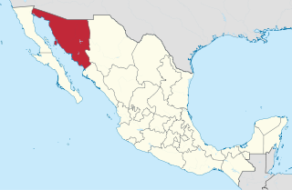
Sonora, officially Estado Libre y Soberano de Sonora, is one of the 31 states which, along with Mexico City, comprise the Federal Entities of Mexico. The state is divided into 72 municipalities; the capital city of which being Hermosillo, located in the center of the state. Other large cities include Ciudad Obregón, Nogales, San Luis Río Colorado, and Navojoa.

31°19′33″N109°32′56″W

<span class="mw-page-title-main">Heroica Nogales</span> City in Sonora, Mexico

Heroica Nogales, more commonly known as Nogales, is a city and the county seat of the Municipality of Nogales. It is located on the northern border of the Mexican state of Sonora. The city is abutted on its north by the city of Nogales, Arizona, across the U.S.-Mexico border.

<span class="mw-page-title-main">Santa Ana, Sonora</span> City in Sonora, Mexico

Santa Ana is a small city and municipal seat of Santa Ana Municipality in the Mexican state of Sonora. It is located 168 kilometres (104 mi) north of the state capital Hermosillo and 100 kilometres (62 mi) south of Nogales on the United States border. The town had a 2005 census population of 10,593 inhabitants.

<span class="mw-page-title-main">Cananea Municipality</span> Municipality in Sonora, Mexico

Cananea is a municipality in the northern portion of the Mexican state of Sonora, on the U.S. border. Its municipal seat is the city of Cananea, located at 30°58′55″N110°18′02″W.

<span class="mw-page-title-main">Mexican Federal Highway 15</span> Highway in Mexico

Federal Highway 15 is Mexico 15 International Highway or Mexico-Nogales Highway, is a primary north-south highway, and is a free part of the federal highways corridors of Mexico. The highway begins in the north at the Mexico–United States border at the Nogales Port of Entry in Nogales, Sonora, and terminates to the south in Mexico City.

<span class="mw-page-title-main">Magdalena de Kino</span> City of Sonora, Mexico

Magdalena de Kino is a city, part of the surrounding municipality of the same name, located in the Mexican state of Sonora covering approximately 560 square miles. According to the 2005 census, the city's population was 23,101, and the municipality's population was 25,500. Magdalena de Kino is in the northern section of Sonora 50 miles from the Mexico-U.S. border. To the north the municipality abuts Nogales; to the south, the municipality of Santa Ana; to the east, Ímuris and Cucurpe; and to the west, the municipalities of Tubutama and Sáric. Its main sectors include San Ignacio, San Isidro, Tacicuri, and Sásabe. The city was named after the pioneer Roman Catholic missionary and explorer, Father Eusebio Francisco Kino, who worked in the area, as well as in the present-day US state of Arizona.

Imuris is the municipal seat of Imuris Municipality in the north of the Mexican state of Sonora.

<span class="mw-page-title-main">Bacoachi</span>

Bacoachi is a small town in Bacoachi Municipality in the north of the Mexican state of Sonora. The area of the municipality is 487 square miles (1,260.65 km²) and the population was 1,456 in 2005, with 924 inhabitants residing in the municipal seat. The elevation of the municipal seat is 4,429 feet above sea level.

<span class="mw-page-title-main">Baviácora</span>

Baviácora is a small town and the municipal seat of the surrounding municipality of the Mexican state of Sonora. The geographical coordinates are 29°42′N110°09′W.

<span class="mw-page-title-main">Arizpe Municipality</span> Municipality in Sonora, Mexico

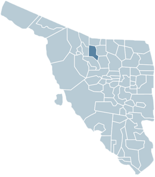
Arizpe (municipality) is a municipality in the Mexican state of Sonora in north-western Mexico. The Municipality of Arizpe is one of the 72 municipalities of the state of Sonora, located in the north-central region of the state in the Sierra Madre Occidental area. It has 72 localities within the municipality, its municipal seat and the most populated locality is the homonymous town of Arizpe, while other important ones are: Sinoquipe, Bacanuchi and Chinapa. It was named for the first time as a municipality in 1813 and according to the 14th Population and Housing Census carried out in 2020 by the National Institute of Statistics and Geography (INEGI) the municipality has a total population of 2,788 inhabitants. This municipality has an area of 1,186.56 square miles (3,073.17 km2). Its Gross Domestic Product per capita is USD 11,012, and its Human Development Index (HDI) is 0.8292.

Carbó (municipality) is a municipality in the Mexican state of Sonora in north-western Mexico.

Guaymas Municipality is a municipality in the Mexican state of Sonora in north-western Mexico. In 2015, the municipality had a total population of 158,046. The municipal seat is the city of Guaymas.

Imuris Municipality is a municipality in the Mexican state of Sonora in north-western Mexico.

<span class="mw-page-title-main">Magdalena de Kino Municipality</span> Municipality in Sonora, Mexico

The Municipality of Magdalena de Kino is a municipality ('county') inthe Mexican state of Sonora in Northwestern Mexico.

<span class="mw-page-title-main">Naco Municipality</span> Municipality in Sonora, Mexico

Naco Municipality is a municipality in the Mexican state of Sonora in northwestern Mexico.

Navojoa Municipality is a municipality inthe Mexican state of Sonora in north-western Mexico. As of 2015, the municipality had a total population of 163,650.

<span class="mw-page-title-main">Puerto Peñasco Municipality</span> Municipality in Sonora, Mexico

Puerto Peñasco Municipality is a municipality in Sonora in north-western Mexico. As of 2015, the municipality had a total population of 62,177 inhabitants. The only locality with a significant population is the municipal seat, also named Puerto Peñasco, which contains almost 99% of the municipality's population.

<span class="mw-page-title-main">History of Sonora</span>

This article details the history of Sonora. The Free and Sovereign State of Sonora is one of 31 states that, with the Federal District, comprise the 32 Federal Entities of Mexico. It is divided into 72 municipalities; the capital city is Hermosillo. Sonora is located in Northwest Mexico, bordered by the states of Chihuahua to the east, Baja California to the northwest and Sinaloa to the south. To the north, it shares the U.S.–Mexico border with the states of Arizona and New Mexico, and on the west has a significant share of the coastline of the Gulf of California.

<span class="mw-page-title-main">Armando López Nogales</span> Mexican politician

Armando López Nogales is a Mexican former lawyer and politician who was the Governor of Sonora from 1997 to 2003 as a member of the Institutional Revolutionary Party (PRI). He also served as a Senator in the LVI Legislature of the Mexican Congress representing Sonora, as well as a federal deputy in the LIV Legislature.

References

  1. "-". Enciclopedia de los Municipios de México. Instituto Nacional para el Federalismo y el Desarrollo Municipal. Archived from the original on July 31, 2012. Retrieved January 4, 2010.
  2. date of the publication of Law No. 29, which had been signed the previous day by the then Governor of Sonora, Luis Emeterio Torres.
  3. Municipio de Nogales. "La rebellion escobarista". Archived from the original on 2007-07-16. Retrieved 2007-10-19.
  4. "Consejo Estatal Electoral de Sonora. Cómputo Global en Ayuntamientos, 2006" (PDF) (in Spanish). Retrieved 14 June 2021.
  5. Gómez Lima, Cristina (March 7, 2021). "Localizan sin vida a Cecilia Yépiz, ex funcionaria de Nogales". jornada.com.mx (in Spanish). La Jornada. Retrieved March 7, 2021.
  6. "Enciclopedia de los Municipios y Delegaciones de México. Estado de Sonora. Nogales" (in Spanish). Retrieved 14 June 2021.
  7. "Buscarán que Interpol y la DEA investiguen la desaparición de exfuncionaria de Nogales". El Universal (in Spanish). 15 February 2021. Retrieved 28 October 2021.
  8. "Tras dos meses de búsqueda, hallan cuerpo de Cecilia Yépiz, ex funcionaria de Nogales". Milenio (in Spanish). 7 March 2021. Retrieved 28 October 2021.
  9. "Vinculan a proceso al sujeto que ejecutó a ex funcionaria de Nogales". Radar Sonora (in Spanish). 24 May 2021. Retrieved 28 October 2021.
  10. City of Nogales. "Municipio de Nogales Official Site". Archived from the original on 2007-05-04. Retrieved 2007-10-19.
  11. City of Nogales. "Municipio de Nogales Official Site". Archived from the original on 2007-05-04. Retrieved 2007-10-19.

31°18′N110°56′W / 31.300°N 110.933°W / 31.300; -110.933