Moore County | |
---|---|
Coordinates: 35°17′N86°22′W / 35.28°N 86.36°W | |
Country | United States |
State | Tennessee |
Founded | 1871 |
Named for | William Moore, state legislator [1] |
Seat | Lynchburg |
Largest city | Lynchburg |
Area | |
• Total | 130 sq mi (300 km2) |
• Land | 129 sq mi (330 km2) |
• Water | 1.2 sq mi (3 km2) 0.9% |
Population (2020) | |
• Total | 6,461 |
• Density | 49/sq mi (19/km2) |
Time zone | UTC−6 (Central) |
• Summer (DST) | UTC−5 (CDT) |
Congressional district | 4th |
Website | Government & Education Services |
Moore County is a county located in the south central part of the U.S. state of Tennessee. As of the 2020 census, the population was 6,461, making it the third-least populous county in Tennessee. [2] It forms a consolidated city-county government with its county seat of Lynchburg. [3] At 130 square miles (340 km2), it is the second-smallest county in Tennessee, behind only Trousdale. The county was created in 1871, during the Reconstruction era. [1] [4] Moore County is part of the Tullahoma-Manchester, TN Micropolitan Statistical Area.
Moore County was established in 1871 from parts of Lincoln, Bedford and Franklin counties, and named in honor of General William Moore, an early settler and long-time member of the state legislature. [1] The new county originally contained about 300 square miles, but Lincoln County sued and successfully reclaimed a portion of its land, reducing the new county's size. [1]
Beginning in the 1820s, whiskey distilleries were developed in what is now Moore County. By 1875, fifteen distilleries were operating in the county. At the end of the 20th century, the Jack Daniel Distillery in Lynchburg was a major employer and the county's primary source of revenue. [1]
Because of the small size of this county, in the late 20th century city and county officials began to discuss creating a consolidated government in order to lower costs and improve services. In 1988, the Metropolitan Government of Lynchburg, Moore County, Tennessee was voted into law as the governing body of Moore County, including Lynchburg. [5] [6]
According to the U.S. Census Bureau, the county has a total area of 130 square miles (340 km2), of which 129 square miles (330 km2) are land and 1.2 square miles (3.1 km2) (0.9%) are water. [7] It is the second-smallest county in Tennessee by area. The county is located partially on the rugged Highland Rim and partially in the flatter Nashville Basin. [1]
Census | Pop. | Note | %± |
---|---|---|---|
1880 | 6,233 | — | |
1890 | 5,975 | −4.1% | |
1900 | 5,706 | −4.5% | |
1910 | 4,800 | −15.9% | |
1920 | 4,491 | −6.4% | |
1930 | 4,037 | −10.1% | |
1940 | 4,093 | 1.4% | |
1950 | 3,948 | −3.5% | |
1960 | 3,454 | −12.5% | |
1970 | 3,568 | 3.3% | |
1980 | 4,510 | 26.4% | |
1990 | 4,721 | 4.7% | |
2000 | 5,740 | 21.6% | |
2010 | 6,362 | 10.8% | |
2020 | 6,461 | 1.6% | |
U.S. Decennial Census [8] 1790-1960 [9] 1900-1990 [10] 1990-2000 [11] 2010-2020 [12] 2020 [2] |
Race | Number | Percentage |
---|---|---|
White (non-Hispanic) | 5,999 | 92.85% |
Black or African American (non-Hispanic) | 103 | 1.59% |
Native American | 17 | 0.26% |
Asian | 29 | 0.45% |
Pacific Islander | 1 | 0.02% |
Other/Mixed | 211 | 3.27% |
Hispanic or Latino | 101 | 1.56% |
As of the 2020 United States census, there were 6,461 people, 2,592 households, and 1,862 families residing in the county.
As of the census [15] of 2010, there were 6,362 people, 2,492 households, and 1,841 families residing in the county. There were 2,492 occupied housing units. The racial makeup of the county was 95.4% White, 2.3% Black or African American, 0.3% Native American, 0.4% Asian, 0.5% from other races, and 1.1% from two or more races. 1.1% of the population were Hispanic or Latino of any race.
There were 2,492 households, out of which 27% had children under the age of 18 living with them, 61.8% were married couples living together, 8.1% had a female householder with no husband present, and 26.1% were non-families. 22.6% of all households were made up of individuals, and 11.0% had someone living alone who was 65 years of age or older, male or female. The average household size was 2.51, and the average family size was 2.93.
In the county, the population was spread out, with 24.2% under the age of 20, 14.8% from 20 to 34, 20.5% from 35 to 49, 22.1% from 50 to 64, and 18.4% who were 65 years of age or older. The median age was 43.3 years.
Per 2000 Census data, the median income for a household in the county was $36,591, and the median income for a family was $41,484. Males had a median income of $31,559 versus $20,987 for females. The per capita income for the county was $19,040. 9.6% of the population, and 7.8% of families were below the poverty line. 11.7% were under the age of 18, and 12.1% were 65 or older.
Moore County is the location of the Jack Daniel Distillery, whose famous brand of Tennessee whiskey is marketed worldwide. Despite the distillery, Moore is a dry county. [16] This status dates to the passage of state prohibition laws in the early 20th century.
While federal prohibition ended in 1933 with the repeal of the Eighteenth Amendment, state prohibition laws remain in effect. All Tennessee counties are dry by default, though any county can become "wet" by passing a county-wide "local option" referendum. Moore County has yet to pass such a referendum. [17]
Schools in Moore County are a part of Moore County Schools, overseen by The Moore County Department of Education: [18]
Motlow State Community College is located in northern part of Moore County.
Year | Republican | Democratic | Third party | |||
---|---|---|---|---|---|---|
No. | % | No. | % | No. | % | |
2020 | 2,888 | 81.60% | 573 | 16.19% | 78 | 2.20% |
2016 | 2,325 | 79.46% | 496 | 16.95% | 105 | 3.59% |
2012 | 2,053 | 73.35% | 705 | 25.19% | 41 | 1.46% |
2008 | 2,010 | 68.09% | 881 | 29.84% | 61 | 2.07% |
2004 | 1,668 | 60.13% | 1,084 | 39.08% | 22 | 0.79% |
2000 | 1,145 | 49.76% | 1,107 | 48.11% | 49 | 2.13% |
1996 | 846 | 42.73% | 935 | 47.22% | 199 | 10.05% |
1992 | 661 | 30.82% | 1,151 | 53.66% | 333 | 15.52% |
1988 | 786 | 51.37% | 731 | 47.78% | 13 | 0.85% |
1984 | 863 | 51.37% | 808 | 48.10% | 9 | 0.54% |
1980 | 551 | 34.55% | 993 | 62.26% | 51 | 3.20% |
1976 | 331 | 22.86% | 1,101 | 76.04% | 16 | 1.10% |
1972 | 608 | 61.04% | 356 | 35.74% | 32 | 3.21% |
1968 | 224 | 15.71% | 346 | 24.26% | 856 | 60.03% |
1964 | 264 | 20.34% | 1,034 | 79.66% | 0 | 0.00% |
1960 | 313 | 26.37% | 863 | 72.70% | 11 | 0.93% |
1956 | 270 | 23.14% | 893 | 76.52% | 4 | 0.34% |
1952 | 354 | 30.00% | 826 | 70.00% | 0 | 0.00% |
1948 | 102 | 12.27% | 523 | 62.94% | 206 | 24.79% |
1944 | 143 | 16.16% | 742 | 83.84% | 0 | 0.00% |
1940 | 106 | 10.79% | 869 | 88.49% | 7 | 0.71% |
1936 | 101 | 12.24% | 719 | 87.15% | 5 | 0.61% |
1932 | 65 | 6.53% | 923 | 92.67% | 8 | 0.80% |
1928 | 133 | 23.29% | 431 | 75.48% | 7 | 1.23% |
1924 | 41 | 7.64% | 492 | 91.62% | 4 | 0.74% |
1920 | 90 | 15.33% | 497 | 84.67% | 0 | 0.00% |
1916 | 71 | 8.95% | 722 | 91.05% | 0 | 0.00% |
1912 | 116 | 14.11% | 694 | 84.43% | 12 | 1.46% |
Lincoln County is a county located in the south central part of the U.S. state of Tennessee. As of the 2020 census, the population was 35,319. Its county seat and largest city is Fayetteville. The county is named for Major General Benjamin Lincoln, an officer in the American Revolutionary War.
Coffee County is a county located in the central part of the state of Tennessee, in the United States. As of the 2020 census, the county's population was 57,889. Its county seat is Manchester. Coffee County is part of the Tullahoma-Manchester, TN Micropolitan Statistical Area. It is also part of Middle Tennessee, one of the three Grand Divisions of the state.
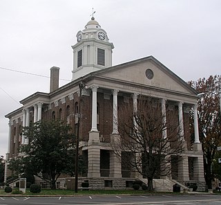
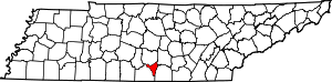
Bedford County is a county located in the U.S. state of Tennessee. As of the 2020 census, the population was 50,237. Its county seat is Shelbyville. Bedford County comprises the Shelbyville, TN Micropolitan Statistical Area, which is also included in the Nashville-Davidson-Murfreesboro, TN Combined Statistical Area.
Lee County is a county located in the U.S. state of South Carolina. As of the 2020 census, its population was 16,531, making it the fifth-least populous county in South Carolina. Its county seat is Bishopville.
Highland County is a county located in the U.S. state of Ohio. As of the 2020 census, the population was 43,317. Its county seat is Hillsboro. The county is named for the topography which is hilly and divides the watersheds of the Little Miami and Scioto Rivers.
Cloverly is an unincorporated town and census-designated place in Montgomery County, Maryland, United States. Its population was 15,285 as of the 2020 census.
Lynchburg is an unincorporated area and census-designated place (CDP) in DeSoto County, Mississippi, United States. The population was 2,437 at the 2010 census.
Harborcreek Township is a township in Erie County, Pennsylvania, United States. The population was 16,630 at the 2020 census, down from 17,234 at the 2010 census, up from 15,178 in 2000. It is part of the Erie Metropolitan Statistical Area.
Gallaway is a city in Fayette County, Tennessee, United States. The population was 680 at the 2010 census.
Winchester is a city in and the county seat of Franklin County, Tennessee, United States. It is part of the Tullahoma micropolitan area. The population of Winchester as of the 2020 census was 9,375.
Palmer is a town in Grundy County, Tennessee, United States. The population was 672 at the 2010 census.
Loudon is a city in and the county seat of Loudon County, Tennessee, United States. Its population was 6,001 at the 2020 census. It is included in the Knoxville, Tennessee Metropolitan Statistical Area. The city is located in East Tennessee, southwest of Knoxville, on the Tennessee River. Fort Loudoun, the colonial era fort for which the city was named, is located several miles to the south in Monroe County.
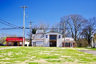
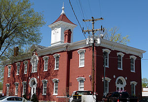
Cornersville is a town in Marshall County, Tennessee, United States. The population was 1,228 at the 2020 census. The town is home to Cornersville high school.
Decatur is a town in Meigs County, Tennessee, United States. The population was 1,563 at the 2020 census. It is the county seat of Meigs County.
Dayton is a city in and the county seat of Rhea County, Tennessee, United States. As of the 2020 census, the city population was 7,065. The Dayton Urban Cluster, which includes developed areas adjacent to the city and extends south to Graysville.
Rustburg is a census-designated place (CDP) in and the county seat of Campbell County, Virginia, United States. The population was 1,585 at the 2020 census. It is part of the Lynchburg Metropolitan Statistical Area.
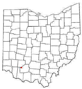
Lynchburg is a village in Clinton and Highland counties in the U.S. state of Ohio. The population was 1,510 at the 2020 census.
Kenton is a town in Gibson and Obion counties, Tennessee. The population was 1,281 at the 2010 census, a decline of 25 from 2000. The Gibson County portion of Kenton is part of the Humboldt, TN Micropolitan Statistical Area, while the Obion County portion is part of the Union City, TN–KY Micropolitan Statistical Area.
Petersburg is a town in Lincoln and Marshall counties in the U.S. state of Tennessee. The population was 580 at the 2000 census and 544 at the 2010 census. It used to be the location of Morgan school before consolidation
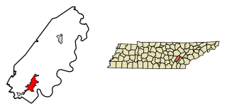
Lynchburg is a city in the south-central region of the U.S. state of Tennessee. It is governed by a consolidated city-county government unit whose boundaries coincide with those of Moore County. Lynchburg is best known as the location of Jack Daniel's distillery, whose famous Tennessee whiskey is marketed worldwide as the product of a city with only one traffic light. Despite the operational distillery, which is a major tourist attraction, Lynchburg's home county of Moore is a dry county. Sampling whiskey is permitted in the distillery, however. The population was 6,461 at the 2020 census.