Trousdale County | |
---|---|
Hartsville-Trousdale County | |
Coordinates: 36°23′N86°10′W / 36.39°N 86.16°W | |
Country | United States |
State | Tennessee |
Founded | September 5, 1870 [1] |
Named for | William Trousdale [2] |
Seat | Hartsville |
Largest town | Hartsville |
Area | |
• Total | 117 sq mi (300 km2) |
• Land | 114 sq mi (300 km2) |
• Water | 2.5 sq mi (6 km2) 2.1% |
Population (2020) | |
• Total | 11,615 |
• Density | 69/sq mi (27/km2) |
Time zone | UTC−6 (Central) |
• Summer (DST) | UTC−5 (CDT) |
Congressional district | 6th |
Website | www |
Trousdale County, also known as Hartsville/Trousdale County, [3] is a county in the U.S. state of Tennessee. As of the 2020 census, the population was 11,615. [4] Its county seat is Hartsville, [5] with which it shares a uniquely formed consolidated city-county government. With an area of just 117 square miles (300 km2), it is Tennessee's smallest county.
Trousdale County is part of the Nashville-Davidson – Murfreesboro – Franklin, TN Metropolitan Statistical Area, although it is located just beyond the ring of "bedroom communities" in the Nashville metropolitan area. Farming and livestock-raising characterize this largely rural area.
Hartsville is the county seat of Trousdale County and now coextensive with it as a metropolitan government by virtue of a referendum which passed in Trousdale County by a single vote. Trousdale County High School is located here, as well as a technical school operated by the Tennessee Board of Regents. Trousdale County is one of two counties in Tennessee to have legalized parimutuel betting on horse racing, but no group has ever stepped forward to build a racetrack. [6]
In 2016, Corrections Corporation of America (since renamed CoreCivic) opened the Trousdale Turner Correctional Center in Hartsville. Its approximately 2,500 prisoners comprise over a fifth of the county's residents and nearly 12% of Tennessee state prisoners. [7] The prison became a hot spot for COVID-19 cases during the COVID-19 pandemic, giving the county the highest incidence rate in the U.S. in May 2020, with 1 in 7 residents known to be infected with coronavirus. [8]
Trousdale County was formed in 1870 from parts of Macon, Smith, Sumner and Wilson counties. It was named for William Trousdale (1790–1872), Brigadier General in the Mexican War, Governor of Tennessee, 1849–1851, and U.S. Minister to Brazil, 1853–1857. Hartsvillians had initially sought the creation of their own, separate county in 1849, but the effort failed.
On December 7, 1862, The Battle of Hartsville occurred within the boundaries of the county (although Trousdale County was not officially a county until 1870), with the Confederate forces under John Hunt Morgan defeating the Union forces of Absalom B. Moore in a surprise attack on their campsite. Morgan captured most of the Union forces and marched them South to Lebanon, Tennessee.
In the early part of the 20th century, a series of floods left the county seat devastated, with some floodwaters reaching flood stage of nine to twelve feet. There are photographs showing residents of the county canoeing in front of the flooded courthouse. [9] During the Second World War, American infantry often trained in Trousdale County, simulating battles and participating in minor war games on the countryside owned by local farmers. After the war, the county flourished with the railroad running through the county. However, after the trains stopped running through the county, business slowed and suffered economically.
In 2020, an outbreak of COVID-19 at the Trousdale Turner Correctional Center, a privately operated prison, made Trousdale County the county with the highest per capita infection rate in the United States as of May 5, 2020. As of May 8, 1,284 prisoners at Trousdale had tested positive for the coronavirus, as had 50 employees and contractors at the facility. [10]
According to the U.S. Census Bureau, the county has a total area of 117 square miles (300 km2), of which 114 square miles (300 km2) is land and 2.5 square miles (6.5 km2) (2.1%) is water. [11] It is the smallest county by area in Tennessee.
Census | Pop. | Note | %± |
---|---|---|---|
1880 | 6,646 | — | |
1890 | 5,850 | −12.0% | |
1900 | 6,004 | 2.6% | |
1910 | 5,874 | −2.2% | |
1920 | 5,996 | 2.1% | |
1930 | 5,629 | −6.1% | |
1940 | 6,113 | 8.6% | |
1950 | 5,520 | −9.7% | |
1960 | 4,914 | −11.0% | |
1970 | 5,155 | 4.9% | |
1980 | 6,137 | 19.0% | |
1990 | 5,920 | −3.5% | |
2000 | 7,259 | 22.6% | |
2010 | 7,870 | 8.4% | |
2020 | 11,615 | 47.6% | |
U.S. Decennial Census [12] 1790-1960 [13] 1900-1990 [14] 1990-2000 [15] 2010-2014 [4] |
Race | Number | Percentage |
---|---|---|
White (non-Hispanic) | 8,786 | 75.64% |
Black or African American (non-Hispanic) | 1,917 | 16.5% |
Native American | 26 | 0.22% |
Asian | 27 | 0.23% |
Other/Mixed | 484 | 4.17% |
Hispanic or Latino | 375 | 3.23% |
As of the 2020 United States census, there were 11,615 people, 3,189 households, and 2,083 families residing in the county.
As of the census [18] of 2000, there were 7,259 people, 2,780 households, and 2,034 families residing in the county. The population density was 64 people per square mile (25 people/km2). There were 3,095 housing units at an average density of 27 units per square mile (10/km2). The racial makeup of the county was 86.57% White, 11.35% Black or African American, 0.23% Native American, 0.11% Asian, 0.03% Pacific Islander, 0.99% from other races, and 0.72% from two or more races. 1.52% of the population were Hispanic or Latino of any race.
There were 2,780 households, out of which 31.90% had children under the age of 18 living with them, 58.30% were married couples living together, 11.30% had a female householder with no husband present, and 26.80% were non-families. 23.00% of all households were made up of individuals, and 10.30% had someone living alone who was 65 years of age or older. The average household size was 2.55 and the average family size was 2.99.
In the county, the population was spread out, with 24.20% under the age of 18, 8.50% from 18 to 24, 28.10% from 25 to 44, 24.90% from 45 to 64, and 14.30% who were 65 years of age or older. The median age was 38 years. For every 100 females, there were 96.90 males. For every 100 females age 18 and over, there were 92.40 males.
The median income for a household in the county was $32,212, and the median income for a family was $37,401. Males had a median income of $27,466 versus $21,207 for females. The per capita income for the county was $15,838. About 9.70% of families and 13.40% of the population were below the poverty line, including 14.00% of those under age 18 and 20.00% of those age 65 or over.
Year | Republican | Democratic | Third party | |||
---|---|---|---|---|---|---|
No. | % | No. | % | No. | % | |
2020 | 2,936 | 73.44% | 1,012 | 25.31% | 50 | 1.25% |
2016 | 2,103 | 66.55% | 946 | 29.94% | 111 | 3.51% |
2012 | 1,612 | 55.49% | 1,240 | 42.69% | 53 | 1.82% |
2008 | 1,688 | 52.11% | 1,475 | 45.54% | 76 | 2.35% |
2004 | 1,314 | 41.18% | 1,851 | 58.01% | 26 | 0.81% |
2000 | 950 | 32.26% | 1,966 | 66.76% | 29 | 0.98% |
1996 | 683 | 27.33% | 1,615 | 64.63% | 201 | 8.04% |
1992 | 565 | 21.21% | 1,846 | 69.29% | 253 | 9.50% |
1988 | 969 | 44.59% | 1,193 | 54.90% | 11 | 0.51% |
1984 | 781 | 40.36% | 1,142 | 59.02% | 12 | 0.62% |
1980 | 629 | 26.72% | 1,674 | 71.11% | 51 | 2.17% |
1976 | 332 | 19.24% | 1,385 | 80.24% | 9 | 0.52% |
1972 | 663 | 53.90% | 539 | 43.82% | 28 | 2.28% |
1968 | 252 | 15.80% | 694 | 43.51% | 649 | 40.69% |
1964 | 205 | 13.90% | 1,270 | 86.10% | 0 | 0.00% |
1960 | 308 | 22.71% | 1,036 | 76.40% | 12 | 0.88% |
1956 | 209 | 16.76% | 1,032 | 82.76% | 6 | 0.48% |
1952 | 261 | 17.43% | 1,236 | 82.57% | 0 | 0.00% |
1948 | 104 | 8.46% | 1,014 | 82.51% | 111 | 9.03% |
1944 | 131 | 10.05% | 1,170 | 89.72% | 3 | 0.23% |
1940 | 94 | 9.17% | 929 | 90.63% | 2 | 0.20% |
1936 | 72 | 8.58% | 765 | 91.18% | 2 | 0.24% |
1932 | 64 | 7.11% | 835 | 92.78% | 1 | 0.11% |
1928 | 179 | 22.74% | 607 | 77.13% | 1 | 0.13% |
1924 | 143 | 17.21% | 684 | 82.31% | 4 | 0.48% |
1920 | 574 | 37.52% | 955 | 62.42% | 1 | 0.07% |
1916 | 217 | 23.98% | 688 | 76.02% | 0 | 0.00% |
1912 | 211 | 26.71% | 544 | 68.86% | 35 | 4.43% |
Hartsville, the county seat, is the only officially constituted municipality in Trousdale County. Unincorporated communities include:
Greensville County is a county located in the Commonwealth of Virginia. As of the 2020 census, the population was 11,391. Its county seat is Emporia.
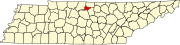
Wilson County is a county in the U.S. state of Tennessee. It is in Middle Tennessee. As of the 2020 census, the population was 147,737. Its county seat is Lebanon. The largest city is Mt. Juliet. Wilson County is part of the Nashville-Davidson–Murfreesboro–Franklin, TN Metropolitan Statistical Area.
Sumner County is a county located on the central northern border of Tennessee in the United States. As of the 2020 United States Census, the population was 196,281. Its county seat is Gallatin, and its most populous city is Hendersonville. The county is named after an American Revolutionary War hero, General Jethro Sumner.
Smith County is a county in the U.S. state of Tennessee. As of the 2020 census, the population was 19,904. Smith County is located in the region of the state known as Middle Tennessee. Its county seat is Carthage. The county was organized in 1799 and is named for Daniel Smith, a Revolutionary War veteran who made the first map of Tennessee and served as a United States senator.
Pickett County is a county located in the U.S. state of Tennessee. As of the 2020 census, the population was 5,001, making it the least populous county in Tennessee. Its county seat is Byrdstown. The city of Byrdstown and the Kentucky town of Albany, 11 miles (18 km) to the northeast, are positioned between two Army Corps of Engineers lakes: Dale Hollow Lake, mainly in Tennessee, and Lake Cumberland, in Kentucky. The area is known as "Twin Lakes" and Byrdstown is noted as "The Gateway To Dale Hollow Lake". Every year thousands of people vacation at the many resorts situated along the lakes.
Moore County is a county located in the south central part of the U.S. state of Tennessee. As of the 2020 census, the population was 6,461, making it the third-least populous county in Tennessee. It forms a consolidated city-county government with its county seat of Lynchburg. At 130 square miles (340 km2), it is the second-smallest county in Tennessee, behind only Trousdale. The county was created in 1871, during the Reconstruction era. Moore County is part of the Tullahoma-Manchester, TN Micropolitan Statistical Area.
Macon County is a county located in the U.S. state of Tennessee As of the 2020 census, the population was 25,216. Its county seat is Lafayette. Macon County is part of the Nashville-Davidson–Murfreesboro–Franklin, TN Metropolitan Statistical Area.
Jefferson County is an exurban county located in the U.S. state of Tennessee. As of the 2020 census, the population was 54,683. Its county seat is Dandridge. Jefferson County is part of the Morristown Metropolitan Statistical Area with neighboring Grainger and Hamblen counties. The county, along with the Morristown MSA, is included in the Knoxville-Morristown-Sevierville Combined Statistical Area.
Jackson County is a county located in the U.S. state of Tennessee. The population was 11,617 at the 2020 census. Its county seat is Gainesboro. Jackson is part of the Cookeville Micropolitan Statistical Area.
Hardeman County is a county located in the U.S. state of Tennessee. As of the 2020 census, the population was 25,462. Its county seat is Bolivar.
Hancock County is a county located in the northeastern part of the U.S. state of Tennessee. As of the 2020 census, the population was 6,662, making it the fourth-least populous county in Tennessee. Its county seat is Sneedville.
Dyer County is a county located in the westernmost part of the U.S. state of Tennessee. As of the 2020 census, the population was 36,801. The county seat is Dyersburg. Dyer County comprises the Dyersburg, TN Micropolitan Statistical Area.
Bledsoe County is a county located in the U.S. state of Tennessee. As of the 2020 census, the population was 14,913. Its county seat is Pikeville.
Darlington County is a county in the U.S. state of South Carolina. As of the 2020 census, its population was 62,905. Its county seat is Darlington. Hartsville is the largest community in the county. Darlington County is home to the Darlington Raceway, which hosts the annual NASCAR Southern 500. Darlington County is also home to Coker College in Hartsville. Darlington County was named by an act in March 1785.
Hartsville is a town in Haw Creek and Clifty townships, Bartholomew County, Indiana, United States. The population was 362 at the 2010 census. It is part of the Columbus, Indiana metropolitan statistical area.
Hartsville is a town in Steuben County, New York, United States. The population was 561 at the 2020 census. The town is named after a prominent early settler, Reuben Hart.
North Hartsville is a census-designated place (CDP) in Darlington County, South Carolina, United States. The population was 3,251 at the 2010 census. It is part of the Florence Metropolitan Statistical Area and the Hartsville Urban Cluster.
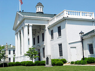
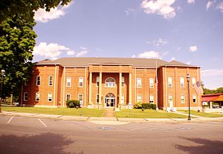
Carthage is a town in and the county seat of Smith County, Tennessee, United States; it is part of the Nashville Metropolitan Statistical Area. The population was 2,306 at the 2010 census. It is located on the Cumberland River, which was important to its early development. It is likely best known as the hometown of former Vice President and Senator Al Gore of the Democratic Party and his father, Senator Albert Gore, Sr. The younger Gore announced his 1988 and 2000 presidential bids, as well as his 1992 vice-presidential bid, from the steps of the Smith County Courthouse.
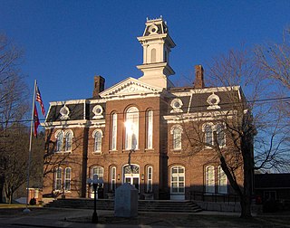
Hartsville is a town in Trousdale County, Tennessee, United States. It is the county seat of Trousdale County, with which it shares a consolidated city-county government. The population of Hartsville was 11,615 as of 2020.
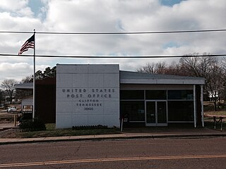
Clifton is a city in Wayne County, Tennessee, on the state's south central border with Alabama. It developed as a river port along the Tennessee River in the 19th century. Its historic districts listed on the National Register of Historic Places are associated with this period. The population was 2,694 at the 2010 census.