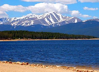
The summit of Mount Elbert at 14,440 feet (4401.2 m) elevation is the highest summit of the Rocky Mountains of North America, the highest point in the U.S. State of Colorado, and the second-highest summit in the contiguous United States after Mount Whitney. The ultra-prominent fourteener is the highest peak in the Sawatch Range, as well as the highest point in the entire Mississippi River drainage basin. Mount Elbert is located in San Isabel National Forest, 12.1 miles (19.4 km) southwest of the City of Leadville in Lake County, Colorado.

Mount Massive is the second-highest summit of the Rocky Mountains of North America and the U.S. state of Colorado. The prominent 14,428-foot (4,398 m) fourteener of the Sawatch Range is located in the Mount Massive Wilderness of San Isabel National Forest, 10.6 miles (17.1 km) west-southwest of the City of Leadville in Lake County, Colorado, United States. Mount Massive edges out the third-highest summit of the Rockies, Mount Harvard, by 7 feet (2.1 m), but falls short of Mount Elbert by 12 feet (3.7 m). It ranks as the third-highest peak in the contiguous United States after Mount Whitney and Mount Elbert.

Mount Adams, elevation 5,793 feet (1,766 m) above sea level, is a mountain in New Hampshire, the second highest peak in the Northeast United States after its nearby neighbor, Mount Washington. Located in the northern Presidential Range, Mount Adams was named after John Adams, the second President of the United States. It was given this name on July 31, 1820. To the northeast is Mount Madison and to the southwest is Mount Jefferson. From the summit, Mount Washington can be seen directly to the south.

Mount Bierstadt is a 14,065-foot-high (4,287 m) mountain summit in the Front Range of the Rocky Mountains, in the U.S. state of Colorado. The fourteener is located in the Mount Evans Wilderness of Pike National Forest, 9.4 miles (15.1 km) south by east of the Town of Georgetown in Clear Creek County. It was named in honor of Albert Bierstadt, an American landscape painter who made the first recorded summit of the mountain in 1863.

Mount of the Holy Cross is a high and prominent mountain summit in the northern Sawatch Range of the Rocky Mountains of North America. The 14,011-foot (4270.5 m) fourteener is located in the Holy Cross Wilderness of White River National Forest, 6.6 miles (10.7 km) west-southwest of the Town of Red Cliff in Eagle County, Colorado, United States. The summit of Mount of the Holy Cross is the highest point in Eagle County and the northern Sawatch Range.

Mount Stuart is a mountain in the Cascade Range, in the U.S. state of Washington. It is the second highest non-volcanic peak in the state, after Bonanza Peak and seventh-highest overall. Mount Stuart is the highest peak in the Stuart Range, and it is located in the central part of the Washington Cascades, south of Stevens Pass and east of Snoqualmie Pass in the Alpine Lakes Wilderness.

Mount Madison is a 5,367-foot (1,636 m) mountain in the Presidential Range of New Hampshire in the United States. It is named after the fourth U.S. President, James Madison.

White Mountain Peak, at 14,252-foot (4,344 m), is the highest peak in the White Mountains of California, the highest peak in Mono County, and the third highest peak in the state after Mount Whitney and Mount Williamson. In spite of its name, the summit block of the peak has large swaths of very dark and colorful orange scree and rock as it is composed of Mesozoic metavolcanic rock - lava lifted and melted by rising granite.

Mount Nebo is the southernmost and highest mountain in the Wasatch Range of Utah, in the United States, and the centerpiece of the Mount Nebo Wilderness, inside the Uinta National Forest. It is named after the biblical Mount Nebo, overlooking Israel from the east of the Jordan River, which is said to be the place of Moses' death.
Castle Peak is the ninth highest summit of the Rocky Mountains of North America and the U.S. state of Colorado. The prominent 14,279-foot (4352.2 m) fourteener is the highest summit of the Elk Mountains and the Maroon Bells-Snowmass Wilderness. The peak is located 11.6 miles (18.7 km) northeast by north of the Town of Crested Butte, Colorado, United States, on the drainage divide separating Gunnison National Forest and Gunnison County from White River National Forest and Pitkin County. The summit of Castle Peak is the highest point of both counties.

Mount Lafayette is a 5,249-foot (1,600 m) mountain at the northern end of the Franconia Range in the White Mountains of New Hampshire, United States. It lies in the town of Franconia in Grafton County, and appears on the New England Fifty Finest list of the most topographically prominent peaks in New England. The mountain's upper reaches are located in the alpine zone, an area where only dwarf vegetation exists due to the harsh climate.
Dix Mountain is the sixth highest peak in the High Peaks Region of the Adirondack Park, and is located roughly on the boundary between the towns of North Hudson and Keene in Essex County, New York. The peak was named in 1837 after John Dix (1798–1879), who was the Secretary of State of New York at the time, and later became the state's governor.

South Twin Mountain is a mountain located in Grafton County, New Hampshire. The mountain is part of the Twin Range of the White Mountains. South Twin forms the high point of a north–south ridge, with North Twin Mountain lying approximately one mile to the north and Mount Guyot two miles (3 km) to the southeast. Galehead Mountain, a lower spur of South Twin, is to the west.

Mount Moosilauke is a 4,802-foot-high (1,464 m) mountain at the southwestern end of the White Mountains in the town of Benton, New Hampshire, United States. It is the tenth highest and most southwesterly of the 4,000 foot summits in the White Mountains.

Mount Monroe is a 5,372-foot-high (1,637 m) mountain peak southwest of Mount Washington in the Presidential Range of the White Mountains in New Hampshire, United States. It is named for American President James Monroe and is the fourth highest mountain on the 4000 footers list for New Hampshire. The Appalachian Trail skirts its summit, which is the next highest peak on or near the trail north of Mount Rogers in Virginia. The Lakes of the Clouds, and its AMC hut, lie nestled at the col between Mount Monroe and neighboring Mount Washington.

Quandary Peak is the highest summit of the Tenmile Range in the Rocky Mountains of North America and is the most commonly climbed fourteener in Colorado. It has nearly the same elevation as Castle Peak and Mount Blue Sky. It lies in Summit County and within the White River National Forest about 6 miles (10 km) south-southwest of the town of Breckenridge.

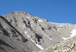
Mount Jefferson is the highest mountain in both the Toquima Range and Nye County in Nevada, United States. It is the sixth highest mountain in the state. As the high point of a range which is well separated from other ranges by low basins, Mount Jefferson has a high topographic prominence of 5,861 feet (1,786 m). This makes it the most prominent peak in Nye County and the third most prominent peak in Nevada. For similar reasons, it is also the highest mountain for over 90 miles in all directions. It is located about 50 miles (80 km) northeast of the county seat of Tonopah within the Alta Toquima Wilderness of the Humboldt-Toiyabe National Forest, near the smaller towns of Carvers and Round Mountain. Three distinct summits are located on a broad area of subalpine tundra: North Summit rises to 11,820 feet (3,603 m), Middle Summit to 11,692 feet (3,564 m), and South Summit to 11,949 feet (3,642 m). During the Pleistocene, alpine glaciers eroded several cirques east of the summit plateau.

Boott Spur is a minor peak located in Coos County, New Hampshire. The mountain is named after Francis Boott (1792–1863), and is part of the Presidential Range of the White Mountains. Boott Spur stands on the shoulder of Mount Washington, above the south side of the headwall of Tuckerman Ravine.

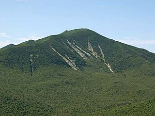
Giant Mountain is the twelfth-highest peak in the High Peaks Region of the Adirondack Park, in New York, USA. The peak is also known as "Giant of the Valley," due to its stature looking over Keene Valley and St. Huberts to the west. The prominent rock slides on the mountain's steep western face and its location away from most other large peaks make it quite an imposing figure, leading to its name.

Sonora Peak is a mountain in the Central Sierra Nevada of California north of Sonora Pass. Located on the boundary between Alpine and Mono counties, it is the highest point in Alpine County. Due to the high elevation, most of the precipitation this mountain receives consists of snow.
