Related Research Articles

The Bhimbetka rock shelters are an archaeological site in central India that spans the Paleolithic and Mesolithic periods, as well as the historic period. It exhibits the earliest traces of human life in India and evidence of Stone Age starting at the site in Acheulian times. It is located in the Raisen District in the Indian state of Madhya Pradesh about 45 kilometres (28 mi) south-east of Bhopal. It is a UNESCO World Heritage Site that consists of seven hills and over 750 rock shelters distributed over 10 km (6.2 mi). At least some of the shelters were inhabited more than 100,000 years ago. The rock shelters and caves provide evidence of, according to Encyclopædia Britannica, a "rare glimpse" into human settlement and cultural evolution from hunter-gatherers, to agriculture, and expressions of prehistoric spirituality.

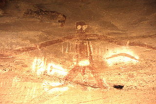
In archaeology, rock art is human-made markings placed on natural surfaces, typically vertical stone surfaces. A high proportion of surviving historic and prehistoric rock art is found in caves or partly enclosed rock shelters; this type also may be called cave art or parietal art. A global phenomenon, rock art is found in many culturally diverse regions of the world. It has been produced in many contexts throughout human history. In terms of technique, the main groups are: petroglyphs, which are carved or scratched into the rock surface, cave paintings, and sculpted rock reliefs. Another technique creates geoglyphs that are formed on the ground. The oldest known rock art dates from the Upper Palaeolithic period, having been found in Europe, Australia, Asia, and Africa. Anthropologists studying these artworks believe that they likely had magico-religious significance.

The Tsodilo Hills are a UNESCO World Heritage Site (WHS), consisting of rock art, rock shelters, depressions, and caves in southern Africa. It gained its WHS listing in 2001 because of its unique religious and spiritual significance to local peoples, as well as its unique record of human settlement over many millennia. UNESCO estimates there are over 4500 rock paintings at the site. The site consists of a few main hills known as the Child Hill, Female Hill, and Male Hill.

Sydney rock engravings, or Sydney rock art, are a form of Australian Aboriginal rock art in the sandstone around Sydney, New South Wales, Australia, that consist of carefully drawn images of people, animals, or symbols. Many thousands of such engravings are known to exist in the Sydney region, although the locations of most are not publicised to prevent damage by vandalism, and to retain their sanctity, as they are still regarded as sacred sites by Indigenous Australians. There are two art environments in Sydney Basin, rock shelters and engraving sites.

Ngarrabullgan, officially named Mount Mulligan by the State, is a large tabletop mountain located 100 kilometres west of Cairns in the north of Queensland (Australia).
An Australian Aboriginal sacred site is a place deemed significant and meaningful by Aboriginal Australians based on their beliefs. It may include any feature in the landscape, and in coastal areas, these may lie underwater. The site's status is derived from an association with some aspect of social and cultural tradition, which is related to ancestral beings, collectively known as Dreamtime, who created both physical and social aspects of the world. The site may have its access restricted based on gender, clan or other Aboriginal grouping, or other factors.

The Prince Henry Hospital site, formerly known as the Prince Henry Hospital, Sydney, is a heritage-listed former teaching hospital and infectious diseases hospital and now UNSW teaching hospital and spinal rehabilitation unit located at 1430 Anzac Parade, Little Bay, City of Randwick, New South Wales, Australia. It was designed by NSW NSW Colonial Architect and NSW Government Architect and built from 1881 by NSW Public Works Department. It is also known as Prince Henry Hospital and The Coast Hospital. The property is owned by Landcom, an agency of the Government of New South Wales. It was added to the New South Wales State Heritage Register on 2 May 2003.

Gabarnmung is an archaeological and rock art site in south-western Arnhem Land, in the Top End of Australia’s Northern Territory. Habitation of the site has been dated to at least 44,000 years ago, placing it among the oldest radiocarbon dated sites in Australia. The oldest rock art was produced more than 28,000 years ago, making it the oldest securely dated prehistoric art in Australia. The cave was still visited by members of the Jawoyn within living memory, possibly until as late as the 1950s, but its existence had been forgotten until its 2006 rediscovery.
The Keilor archaeological site was among the first places to demonstrate the antiquity of Aboriginal occupation of Australia when a cranium, unearthed in 1940, was found to be nearly 15,000 years old. Subsequent investigations of Pleistocene alluvial terraces revealed hearths about 31,000 years BP, making Keilor one of the earliest sites of human habitation in Australia. Remains of megafauna suggest a possible association with Aboriginal hunting.

Aboriginal sites of Victoria form an important record of human occupation for probably more than 40,000 years. They may be identified from archaeological remains, historical and ethnographic information or continuing oral traditions and encompass places where rituals and ceremonies were performed, occupation sites where people ate, slept and carried out their day to day chores, and ephemeral evidence of people passing through the landscape, such as a discarded axe head or isolated artefact.
New Guinea II is a limestone cave and rockshelter on the Snowy River at the end of New Guinea Track, near Buchan, Victoria. The cave was within the country of the Krowathunkooloong clan of the Gunaikurnai nation. The deep cave system has an overhanging cliff that creates a rock shelter at the entrance facing the river. Excavations in the 1980s carried out by archaeologist Paul Ossa and a team from La Trobe University found stone artefacts, and other signs of occupation that were dated to almost 20,000 BP.
Cloggs Cave is a limestone cave and rockshelter with significant Aboriginal archaeological deposits, located on a cliff along the Snowy River gorge near the town of Buchan, Victoria.
Kutikina Cave is a rock shelter located on the Franklin River in the South West Wilderness, a World Heritage Area in the Australian state of Tasmania.
Warratyi is the site of a prehistoric rock shelter in the Flinders Ranges in South Australia. Located around 550 kilometres (340 mi) north of Adelaide and about 200 kilometres (120 mi) inland, it has been identified as the oldest known site of human habitation in inland Australia. Newspapers reported that this rock shelter was discovered by chance in 2011 by a local resident who stumbled upon it while looking for somewhere to go to the toilet. Researchers found thousands of artefacts and bone fragments, which enabled them to date the shelter's occupation to a number of periods between 49,000 and 10,000 years ago. The finds include the earliest evidence in Australia of the development of bone and stone-axe technology, the use of ochre, and interaction with megafauna such asDiprotodon.
Madjedbebe is a sandstone rock shelter in Arnhem Land, in the Northern Territory of Australia, said to be the site of the oldest evidence of human habitation in the country. It is located about 50 kilometres (31 mi) from the coast. It is part of the lands traditionally inhabited by the Mirarr, an Aboriginal Australian clan of the Gaagudju people, of the Gunwinyguan language group. Although it is surrounded by the World Heritage Listed Kakadu National Park, Madjedbebe itself is located within the Jabiluka Mineral Leasehold.
The Blacks Camp is a heritage-listed former post-contact Aboriginal Australian occupation site and now residence, agricultural land and vacant land located at University Road, Wellington in the Dubbo Regional Council local government area of New South Wales, Australia. It is also known as Black's Camp and The Spring Flats. The property is owned by New South Wales Land and Property Information (LPI), an agency of the Government of New South Wales. The property was added to the New South Wales State Heritage Register on 18 November 2011.
Parramatta Sand Body Conservation Area and Military Barracks Site is a heritage-listed archaeological site relating to both Aboriginal and European occupation at George and Harris Streets, Harris Park, City of Parramatta, Sydney, New South Wales, Australia. It was added to the New South Wales State Heritage Register on 8 July 2011.
Bambata Cave is one of the Southern Africa prehistoric sites situated in Motobo National Park along with Inanke, Nswatugi, Pomengwe and Silozwane caves in Zimbabwe.
Earlwood Aboriginal Art Site is a heritage-listed Aboriginal cultural site at Earlwood, City of Canterbury-Bankstown, New South Wales, Australia. It is also known as Aboriginal Art and Midden. It was added to the New South Wales State Heritage Register on 27 November 2009.
Calga Aboriginal Cultural Landscape is a heritage-listed site at Peats Ridge Road, Calga, Central Coast Council, New South Wales, Australia. It is also known as Calga Aboriginal Women's Site and Calga Aboriginal Sites. It was added to the New South Wales State Heritage Register on 1 October 2019.
References
- ↑ R.G. Gunn. Mudgegonga 2, Aboriginal rock art site (Site 8224/001) : a detailed recording of the art and its context with an assessment of its archaeological significance, Victoria Archaeological Survey, Melbourne, 1987
- ↑ Aldo Massola, The rock-shelter at Mudgegonga, Field Naturalists Club of Victoria, Vol. 83 No. 4 April 1966
- ↑ Graham Frederick Perham, Mud and stone: a technological analysis of a quartz industry in North East Victoria, La Trobe University, Dept. of Archaeology, 1985
- ↑ Rock art restoration plan seen as desecration, Jewel Topsfield, The Age December 8, 2008
- Josephine Flood, Archaeology of the Dreamtime, J. B. Publishing