Organisation that produces maps and geographic information of a country
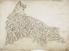
The original draftsman's drawings for the area around St. Columb Major, Cornwall, made in 1810.
A national mapping agency is an organisation, usually publicly owned, that produces topographic maps and geographic information of a country. Some national mapping agencies also deal with cadastral matters.
According to 2007/2/EC European directive, national mapping agencies of European Union countries must have publicly available services for searching, viewing and downloading their spatial data.[1] Maps produced by some of them are available under a free license that allows re-use, such as a Creative Commons license.[2]
History
Ordnance Survey
The first national mapping agency was the Ordnance Survey in the United Kingdom;[3][4] its roots go back to 1747, when the compilation of a map of the Scottish Highlands was proposed.[5][6] This survey at a scale of 1inch to 1000 yards (1:36,000)[7] was the starting point of the Principal Triangulation of Great Britain (1783–1853), and led to the creation of the Ordnance Survey itself; work was begun in earnest in 1790, when the Board of Ordnance began a national military survey at one-inch-to-the-mile (1:63,360 scale).[8] During the next thirty years, roughly a third of England and Wales was mapped (see Principal Triangulation of Great Britain), as other military matters took precedence.[9]
State Service of Ukraine for Geodesy, Cartography and Cadastre (StateGeoCadastre); Ukrainian: Derzhavna sluzhba Ukrainy z pytan heodezii, kartohrafii ta kadastru (DerzhHeoKadastr)
Although virtually the entire terrestrial surface of Earth has been mapped at scale 1:1,000,000, medium and large-scale mapping has been accomplished intensively in some countries and much less in others.[12] Nevertheless, national mapping programs listed below are only a partial selection. Several commercial vendors supply international topographic map series.
Australia
The NMIG (National Mapping Information Group) of Geoscience Australia is the Australian Government's national mapping agency. It provides topographic maps and data to meet the needs of the sustainable development of the nation. The Office of Spatial Data Management provides an online free map service MapConnect.[13] These topographic maps of scales 1:250,000 and 1:100,000 are available in printed form from the Sales Centre.[14] 1:50,000 and 1:25,000 maps are produced in conjunction with the Department of Defence.[15]
Austria
Austrian Maps (German: Österreichische Karte (ÖK)) is the government agency producing maps of Austria, which are distributed by Bundesamt für Eich- und Vermessungswesen (BEV) in Vienna. The maps are published at scales 1:25,000 1:50,000 1:200,000 and 1:500,000. Maps can also be viewed online.[16]
Canada
The Centre for Topographic Information produces topographic maps of Canada at scales of 1:50,000 and 1:250,000. The full map catalogue is known as the National Topographic System (NTS).[17] A government proposal to discontinue publishing of all hardcopy or paper topographic maps in favor of digital-only mapping data was shelved in 2005 after intense public opposition.[18]
China
The State Bureau of Surveying and Cartography compiles topographic maps at 1:25,000 and 1:50,000 scales. It is reported that these maps are accurate and attractively printed in seven colors, and that successive editions show progressive improvement in accuracy.[19]
These large-scale maps are the basis for maps at smaller scales. Maps at scales 1:4,000,000 or smaller are exported by Cartographic Publishing House, Beijing while larger-scale maps are restricted as state secrets, and prohibited from publishing by legislation, all except Hong Kong and Macau. China's topographic maps follow the international system of subdivision with 1:100,000 maps spanning 30 minutes longitude by 20 minutes latitude.[20]
Colombia
The Geographic Institute Agustín Codazzi is the government entity responsible for producing and distributing topographic maps of Colombia in 1:500,000 and 1:100,000 scales. These and several other Geographic information services can be accessed using the Instituto Geográfico Agustin Codazzi website[21] in Spanish.
The National Land Survey of Finland produces the Topographic Database (accuracy 1:5000-1:10 000) and publishes topographic maps of Finland at 1:25,000 and 1:50,000. In addition topographics maps can be viewed by using a free map service MapSite.[23][24]
In principle, each federal state (Bundesland) is in charge of producing the official topographic maps. In fact, the maps between 1:5,000 and 1:100,000 are produced and published by the land surveying offices of each federal state, the maps between 1:200,000 and 1:1,000,000 by a federal house – the Bundesamt für Kartographie und Geodäsie (BKG) in Frankfurt am Main.[26][bettersourceneeded]
Greece
Topographic maps for general use are available at 1:50,000 and 1:100,000 from the Hellenic Military Geographical Service (HMGS).[27] They use a national projection system called EGSA'87, which is a Transverse Mercatorial Projection mapping Greece in one zone. A few areas are also available at 1:25,000. Some private firms sell topographic maps of national parks based on HMGS topography.
Hong Kong
The Department of Lands is the government agency responsible for surveying and publishing topographic maps of Hong Kong. Commonly used maps such as the HM20C series (1:20,000) are reviewed and updated every year or two. Very large scale (1:600 in Urban area and the 1:1,000 HM1C series for all of HK) topographic maps are also available to public for various uses.[28]
India
The Survey of India is responsible for all topographic control, surveys and mapping of India.[29]
Israel
The Survey of Israel is responsible for the civilian mapping of Israel. Standard map scales are 1:50,000 and 1:100,000. The 1:50,000 map is available online.[30]
Topographic sheets at 1:25,000 scale covering 7.5 minutes latitude and longitude map the densely populatedTerai and Middle Mountain regions. Less populated high mountain regions are on 15-minute sheets at 1:50,000. JPG scans can be downloaded.[35] Currently, Survey Department is updating it's topographical base map using ZY-3 imagery. The first update phase completed 208 sheets [36]
Netherlands
The Land Registry Kadaster (formerly Topografische Dienst) collects, processes and provides topographical information of the entire Dutch territory. The history of the Land Registry goes back to the year 1815, that year was commissioned to create a large map, known as Map of Krayenhoff. Around 1836 they began printing the topographic map on a scale of 1: 50,000, followed in 1865 by the topographic map on a scale of 1: 25,000. In 1951 began the start of production of the topographic map on a scale of 1: 10,000. From various reorganizations arose in 1932 the Topografische Dienst as national mapping agency of the Netherlands, since January 2004 housed within the Land Registry Kadaster.
New Zealand
Land Information New Zealand is the government agency responsible for providing up-to-date topographic mapping. LINZ topographic maps cover all of New Zealand, offshore islands, some Pacific Islands and the Ross Sea Region.[37] The standard issue NZTopo map series was published September 2009 at 1:50,000 (NZTopo50), and 1:250,000 (NZTopo250). Vector data[38] from the New Zealand Topographic Database (NZTopo) is also available.
Pakistan
The responsibility for topographic mapping and aerial photography lies with the Surveyor General of Pakistan [SGP]. Established in 1947, the Survey of Pakistan (SOP) is based in Rawalpindi with a number of regional offices distributed at urban centers throughout Pakistan. SGP is a civil organization which, for security reasons, is headed by a Surveyor General and works under the strict control of Army General Headquarters (GHQ). Colonel C.A.K. Innes-Wilson, a Royal Engineers officer who joined the Survey of India which mapped the subcontinent, was the first Surveyor General of Pakistan.
All departments which require topographic maps make their request to SGP and many are permanently registered with it for mapping and aerial photographs procurement. The SOP performs these functions under the auspices of the Ministry of Defence (MOD). Organisationally, the SOP is overseen by the Surveyor General (SG) who is a direct military appointee and a senior uniformed officer. The SG reports directly to the Secretary of Defence. Under the SG are two Deputy SG's (I and II) who manage the operational departments of the agency and a Senior Technical Advisor. These departments are divided into Regional Directorates for Topographic Mapping including the Northern region centred in Peshawar, Eastern region (Lahore), Western region (Quetta) and finally, the Southern region in Karachi. Responsibility for fields surveys and the maintenance/update of topographic maps are sub-divided according to these geographic areas.
Portugal
The Army's Geographical Institute – Instituto Geográfico do Exército – produces 1.25,000, 1:500,000 maps for public sale, as well as many geographical services.
Romania
Until recently, the two major government mapping authorities in Romania have been the Military Topographic Department (Directia Topografica Militara (DTM)), and the Institute for Geodesy, Photogrammetry, Cartography and Land Management (Institutul de Geodezie, Fotogrammetrie, Cartografie, si Organizarea Teritoriului (IGFCOT)). This situation has recently changed, following a decision in 1996 by the Romanian Government to establish a combined civilian National Office of Cadastre, Geodesy and Cartography (Oficiul National de Cadastru, Geodezie si Cartografie (ONCGC). Maps continued to be published under the imprint of the previous organizations into the late 1990s. From 1958, a number of town maps at scales of 1:5,000 or 1:10,000 were also made, initially on the Gauss-Krϋger projection, but after 1970 on a stereographic projection. More than 100 such sheets have been produced. There is also a street map of Bucharest in four sheets at 1:15,000 derived from larger-scale surveys, which is revised annually.
The 1:50,000 series in 737 sheets is now regarded as the base map. It was revised in the period 1965–72 using aerial photographs, and is currently being updated again with the intention of establishing a revision cycle of five to six years. The 1:25,000 will be retained, but revision only at 15-20-year intervals, except for sheets covering areas of rapid change.
Russia
Detailed, accurate topographic maps have long been a military priority. They are currently produced by the Military-topographic service of armed forces of the Russian Federation (Russian: Военно-топографическая служба Вооружённых сил Российской Федерации or ВТС ВС). Military topographic mapping departments held other titles in the Russian Empire since 1793 and in the Soviet Union[39][bettersourceneeded] where these maps also came to be used for internal control and economic development.
The Soviet Union conducted the world's most comprehensive cartographic project of the twentieth century.[40] Soviet map sheets adopted the global sheet nomenclature of the International Map of the World system and already covered foreign territories by 1938.[41] When Germany invaded in 1941, detailed maps from the USSR's western borders to the Volga River became an urgent task, accomplished in less than one year. After the war years the entire Soviet Union was mapped at scales down to 1:25,000—even 1:10,000 for the agriculturally productive fraction. The rest of the world except Antarctica is believed to have been mapped at scales down to 1:200,000, with regions of special interest down to 1:50,000 and many urban areas to 1:10,000. In all there may have been over one million map sheets[42] of high quality and detail.[43][44][45] Soviet maps were also notable for their consistent global indexing system.[46][47][bettersourceneeded] These advantages held for Soviet military maps of other countries, although there were some errors due to faulty intelligence.[48]
Soviet maps for domestic civilian purposes were often of lower quality.[49] From 1919 to 1967 they were produced by Head geodesic administration (Russian: Высшее геодезическое управление or ВГУ), then by Chief administration of geodesy and cartography (Russian: Главное управление геодезии и картографии or ГУГК). Now (June 2011) civilian maps are produced by the Federal agency for geodesy and cartography (Russian: Федеральное агентство геодезии и картографии or Роскартография).[50][bettersourceneeded]
Soviet military maps were state secrets. After the 1991 breakup of the Soviet Union, many maps leaked into the public domain.[51] Map scales 1:100.000–1:500.000 can be viewed online.[52][53]
Spain
The Instituto Geográfico Nacional (IGN) is responsible for the official topographic maps.[54] It does use six scales that cover all the Spanish territory: 1:25,000 (map series called MTN25), 1:50,000 (map series called MTN50), 1:200,000, 1:500,000, 1:1,000,000 and 1:2,000,000. The most common scale is the first one, which utilizes the UTM system.
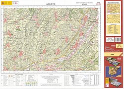
Sheet #535 (2013 version; second digital edition) of MTN50 Spanish National Topographic map series, covering Algete town (near Madrid) and its surroundings.
Swisstopo (the Federal Office of Topography) produces topographic maps of Switzerland at seven different scales.
Taiwan
Topographic maps for Taiwan had long been kept as confidential information due to security concerns. It has only been recently made available to public from the National Land Surveying and Mapping Center, the government agency responsible for surveying and publishing various maps. Topographic maps of up to 1:25,000 is now available in digital and printed format.[55]
United Kingdom
The Ordnance Survey (OS) produces topographic map series covering Great Britain at 1:25,000 and 1:50,000 scales.[56] The 1:25,000 scale is known as the "Explorer" series, and include an "OL" (Outdoor Leisure) sub-series for areas of special interest to hikers and walkers. It replaced the "Pathfinder" series, which was less colourful and covered a smaller area on each map. The 1:50,000 scale is known as the "Landranger" and carries a distinctive pink cover. More detailed mapping as fine as 1:10,000 covers some parts of the country.[57] The 1:25,000 and 1:50,000 scales are easily coordinated with standard romer scales on currently available compasses and plotting tools. The Ordnance Survey maintains a mapping database from which they can print specialist maps at virtually any scale.[58]
The United States Geological Survey (USGS), a scientific federal agency, produces several national series of topographic maps which vary in scale and extent, with some wide gaps in coverage, notably the complete absence of 1:50,000 scale topographic maps or their equivalent. The largest (both in terms of scale and quantity) and best-known topographic series is the 7.5-minute or 1:24,000 quadrangle. This scale is unique to the United States,[citation needed] where nearly every other developed nation has introduced a metric 1:25,000 or 1:50,000 large scale topo map. The USGS also publishes 1:100,000 maps covering 30 minutes latitude by one degree longitude, 1:250,000 covering one by two degrees, and state maps at 1:500,000 with California, Michigan and Montana needing two sheets while Texas has four. Alaska is mapped on a single sheet, at scales ranging from 1:1,584,000 to 1:12,000,000.[59][citation needed]
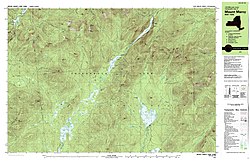
The southern half of same area about a century later (1979) in a 7.5- by 15-minute metric map at 1:25,000.
Recent USGS digital National Map omits several important geographic details that were featured in the original USGS topographic map series (1945–1992).[60] Examples of omitted details and features include power transmission lines, telephone lines, railroads, recreational trails, pipelines, survey marks, and buildings.[60] For many of these feature classes, the USGS is working with other agencies to develop data or adapt existing data on missing details that will be included in The National Map.[60] In other areas USGS digital map revisions may omit geographic features such as ruins, mine locations, springs, wells, and even trails in an effort to protect natural resources and the public at large, or because such features are not present in any public domain database.[60]
In modern mapping, a topographic map or topographic sheet is a type of map characterized by large-scale detail and quantitative representation of relief features, usually using contour lines, but historically using a variety of methods. Traditional definitions require a topographic map to show both natural and artificial features. A topographic survey is typically based upon a systematic observation and published as a map series, made up of two or more map sheets that combine to form the whole map. A topographic map series uses a common specification that includes the range of cartographic symbols employed, as well as a standard geodetic framework that defines the map projection, coordinate system, ellipsoid and geodetic datum. Official topographic maps also adopt a national grid referencing system.
Topography is the study of the forms and features of land surfaces. The topography of an area may refer to the land forms and features themselves, or a description or depiction in maps.
An orthophoto, orthophotograph, orthoimage or orthoimagery is an aerial photograph or satellite imagery geometrically corrected ("orthorectified") such that the scale is uniform: the photo or image follows a given map projection. Unlike an uncorrected aerial photograph, an orthophoto can be used to measure true distances, because it is an accurate representation of the Earth's surface, having been adjusted for topographic relief, lens distortion, and camera tilt.
The National Topographic System or NTS is the system used by Natural Resources Canada for providing general purpose topographic maps of the country. NTS maps are available in a variety of scales, the standard being 1:50,000 and 1:250,000 scales. The maps provide details on landforms and terrain, lakes and rivers, forested areas, administrative zones, populated areas, roads and railways, as well as other human-made features. These maps are currently used by all levels of government and industry for forest fire and flood control, depiction of crop areas, right-of-way, real estate planning, development of natural resources and highway planning. To add context, land area outside Canada is depicted on the 1:250,000 maps, but not on the 1:50,000 maps.
A geologic map or geological map is a special-purpose map made to show various geological features. Rock units or geologic strata are shown by color or symbols. Bedding planes and structural features such as faults, folds, are shown with strike and dip or trend and plunge symbols which give three-dimensional orientations features.
Norge 1:50 000 is the main series of 727 topographical maps in 1:50,000 scale that cover the entire mainland area of Norway and proximate islands. The civilian designation is Norway 1:50 000 and the military designation is M711.
The Wojskowy Instytut Geograficzny (WIG) was the Polish Military Geographical Institute from 1919 until 1949. Colonel Józef Kreutzinger was the Head of the Institute from 1926.
The Royal Australian Survey Corps was a Corps of the Australian Army, formed on 1 July 1915 and disbanded on 1 July 1996. As one of the principal military survey units in Australia, the role of the Royal Australian Survey Corps was to provide the maps, aeronautical charts, hydrographical charts and geodetic and control survey data required for land combat operations.
The Instituto Geográfico Nacional (IGN), or National Geographic Institute is a Spanish government agency, dependent on the Spanish Ministry of Public Works. It is the national mapping agency for Spain, together with the Centro Nacional de Información Geográfica (CNIG).
The British Cartographic Society (BCS) is an association of individuals and organisations dedicated to exploring and developing the world of maps. It is a registered charity. Membership includes national mapping agencies, publishers, designers, academics, researchers, map curators, individual cartographers, GIS specialists and ordinary members of the public with an interest in maps.
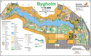
An orienteering map is a map specially prepared for use in orienteering events. It is a large-scale topographic map with extra markings to help the participant navigate through the course.
The Ordnance Survey (OS) is the national mapping agency for Great Britain. The agency's name indicates its original military purpose, which was to map Scotland in the wake of the Jacobite rising of 1745. There was also a more general and nationwide need in light of the potential threat of invasion during the Napoleonic Wars. Since 1 April 2015, the Ordnance Survey has operated as Ordnance Survey Ltd, a government-owned company, 100% in public ownership. The Ordnance Survey Board remains accountable to the Secretary of State for Science, Innovation and Technology. It was also a member of the Public Data Group.
The Ethiopian Mapping Agency (EMA) is an Ethiopian government agency, a department within the Ministry of Finance and Cooperation, that is responsible for cartographic mapping and remote sensing activities in Ethiopia. The EMA has expanded its operation to include a comprehensive map revision program in addition to various phases of digital mapping and information technology.
The United States Geological Survey (USGS), founded as the Geological Survey, is an agency of the United States government whose work spans the disciplines of biology, geography, geology, and hydrology. The agency was founded on March 3, 1879, to study the landscape of the United States, its natural resources, and the natural hazards that threaten it. The agency also makes maps of extraterrestrial planets and moons based on data from U.S. space probes.
A Digital Line Graph (DLG) is a cartographic map feature represented in digital vector form that is distributed by the U.S. Geological Survey (USGS). DLGs are collected from USGS maps and are distributed in large, intermediate and small scale with up to nine different categories of features, depending on the scale. They come in optional and Spatial Data Transfer Standard (SDTS) format and are topologically structured for use in mapping and geographic information system (GIS) applications.
A map series is a group of topographic or thematic charts or maps usually having the same scale and cartographic specifications, and with each sheet appropriately identified by its publisher as belonging to the same series.
Survey of Israel - SOI is the survey and mapping department of the Israeli Ministry of Housing and Construction. It is the successor of the Survey Department of Palestine, which existed in Mandatory Palestine between 1920 and 1948.
Survey of Pakistan is the sole national mapping and land surveying government agency of Pakistan. Its head of department is titles as "Surveyor General of Pakistan".
The Army Map Service (AMS) was the military cartographic agency of the United States Department of Defense from 1941 to 1968, subordinated to the United States Army Corps of Engineers. On September 1, 1968, the AMS was redesignated the U.S. Army Topographic Command (USATC) and continued as an independent organization until January 1, 1972, when it was merged into the new Defense Mapping Agency (DMA) and redesignated as the DMA Topographic Center (DMATC). On October 1, 1996, DMA was folded into the National Imagery and Mapping Agency (NIMA), which was redesignated as the National Geospatial-Intelligence Agency (NGA) in 2003.
Alexander James Kent is a British cartographer, geographer and academic, currently serving as Vice President of the International Cartographic Association. He leads the Coastal Connections Project for World Monuments Fund and English Heritage and is honorary Reader in Cartography and Geographical Information Science at Canterbury Christ Church University (CCCU) and also a senior research associate of the Oxford Centre for Islamic Studies at the University of Oxford.
↑ Organisation., c=AU; o=Commonwealth of Australia; ou=Department of Defence; ou=Australian Geospatial-Intelligence. "AGO: Home". www.defence.gov.au. Archived from the original on 11 September 2016. Retrieved 1 May 2018.{{cite web}}: CS1 maint: multiple names: authors list (link)
↑ "Nepal-Topo Maps". PAHAR Mountains of Central Asia Digital Dataset. MyPublisher. 2013-03-09. Archived from the original on 5 January 2014. Retrieved 31 January 2014.
↑ Davies, John; Kent, Alexander J. (2017). The Red Atlas. Chicago: University of Chicago Press. ISBN978-0226389578.
↑ David Watt (December 2005). "Soviet Military Mapping"(PDF). Sheetlines. 74: 9–12. Archived from the original(PDF) on 7 August 2011. Retrieved 5 June 2011.
↑ Postnikov, Alexey (2002). "Maps for Ordinary Consumers versus Maps for the Military: Double Standards of Map Accuracy in Soviet Cartography, 1917–1991". Cartography and Geographic Information Science. 29 (3): 243–260. doi:10.1559/152304002782008431. S2CID140680368.
↑ Geográfica, Organismo Autónomo Centro Nacional de Información. "Centro de Descargas del CNIG (IGN)". Centro de Descargas del CNIG (in Spanish). Retrieved 2022-06-28.
↑ The MasterMapTopography Layer contains information about buildings, roads, woodland, administrative boundaries, etc., with just a few spot heights along the roads. For contours or a digital terrain model, a separate product called OS TerrainArchived 1 July 2013 at the Wayback Machine is required.
This page is based on this Wikipedia article Text is available under the CC BY-SA 4.0 license; additional terms may apply. Images, videos and audio are available under their respective licenses.