The First Law of Geography, according to Waldo Tobler, is "everything is related to everything else, but near things are more related than distant things." This first law is the foundation of the fundamental concepts of spatial dependence and spatial autocorrelation and is utilized specifically for the inverse distance weighting method for spatial interpolation and to support the regionalized variable theory for kriging. The first law of geography is the fundamental assumption used in all spatial analysis.
Health geography is the application of geographical information, perspectives, and methods to the study of health, disease, and health care. Medical geography, a sub-discipline of, or sister field of health geography, focuses on understanding spatial patterns of health and disease in relation to the natural and social environment. Conventionally, there are two primary areas of research within medical geography: the first deals with the spatial distribution and determinants of morbidity and mortality, while the second deals with health planning, help-seeking behavior, and the provision of health services.

Spatial analysis is any of the formal techniques which studies entities using their topological, geometric, or geographic properties. Spatial analysis includes a variety of techniques using different analytic approaches, especially spatial statistics. It may be applied in fields as diverse as astronomy, with its studies of the placement of galaxies in the cosmos, or to chip fabrication engineering, with its use of "place and route" algorithms to build complex wiring structures. In a more restricted sense, spatial analysis is geospatial analysis, the technique applied to structures at the human scale, most notably in the analysis of geographic data. It may also be applied to genomics, as in transcriptomics data.

The modifiable areal unit problem (MAUP) is a source of statistical bias that can significantly impact the results of statistical hypothesis tests. MAUP affects results when point-based measures of spatial phenomena are aggregated into spatial partitions or areal units as in, for example, population density or illness rates. The resulting summary values are influenced by both the shape and scale of the aggregation unit.
Spatial epidemiology is a subfield of epidemiology focused on the study of the spatial distribution of health outcomes; it is closely related to health geography.
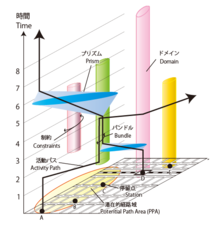
Time geography or time-space geography is an evolving transdisciplinary perspective on spatial and temporal processes and events such as social interaction, ecological interaction, social and environmental change, and biographies of individuals. Time geography "is not a subject area per se", but rather an integrative ontological framework and visual language in which space and time are basic dimensions of analysis of dynamic processes. Time geography was originally developed by human geographers, but today it is applied in multiple fields related to transportation, regional planning, geography, anthropology, time-use research, ecology, environmental science, and public health. According to Swedish geographer Bo Lenntorp: "It is a basic approach, and every researcher can connect it to theoretical considerations in her or his own way."
Statistical geography is the study and practice of collecting, analysing and presenting data that has a geographic or areal dimension, such as census or demographics data. It uses techniques from spatial analysis, but also encompasses geographical activities such as the defining and naming of geographical regions for statistical purposes. For example, for the purposes of statistical geography, the Australian Bureau of Statistics uses the Australian Standard Geographical Classification, a hierarchical regionalisation that divides Australia up into states and territories, then statistical divisions, statistical subdivisions, statistical local areas, and finally census collection districts.

Geography is the study of the lands, features, inhabitants, and phenomena of Earth. Geography is an all-encompassing discipline that seeks an understanding of Earth and its human and natural complexities—not merely where objects are, but also how they have changed and come to be. While geography is specific to Earth, many concepts can be applied more broadly to other celestial bodies in the field of planetary science. Geography has been called "a bridge between natural science and social science disciplines."
Geographic information systems (GISs) and geographic information science (GIScience) combine computer-mapping capabilities with additional database management and data analysis tools. Commercial GIS systems are very powerful and have touched many applications and industries, including environmental science, urban planning, agricultural applications, and others.
A boundary problem in analysis is a phenomenon in which geographical patterns are differentiated by the shape and arrangement of boundaries that are drawn for administrative or measurement purposes. The boundary problem occurs because of the loss of neighbors in analyses that depend on the values of the neighbors. While geographic phenomena are measured and analyzed within a specific unit, identical spatial data can appear either dispersed or clustered depending on the boundary placed around the data. In analysis with point data, dispersion is evaluated as dependent of the boundary. In analysis with areal data, statistics should be interpreted based upon the boundary.
Quantitative geography is a subfield and methodological approach to geography that develops, tests, and uses scientific, mathematical, and statistical methods to analyze and model geographic phenomena and patterns. It aims to explain and predict the distribution and dynamics of human and physical geography through the collection and analysis of quantifiable data. The approach quantitative geographers take is generally in line with the scientific method, where a falsifiable hypothesis is generated, and then tested through observational studies. This has received criticism, and in recent years, quantitative geography has moved to include systematic model creation and understanding the limits of their models. This approach is used to study a wide range of topics, including population demographics, urbanization, environmental patterns, and the spatial distribution of economic activity. The methods of quantitative geography are often contrasted by those employed by qualitative geography, which is more focused on observing and recording characteristics of geographic place. However, there is increasing interest in using combinations of both qualitative and quantitative methods through mixed-methods research to better understand and contextualize geographic phenomena.
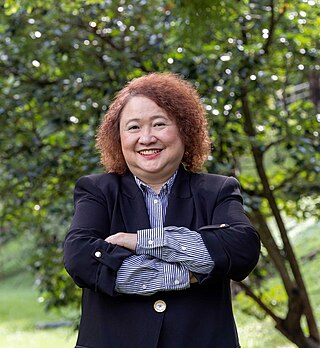
Mei-Po Kwan is a geographer known for her research contributions in Geographic Information Science, and human geography, particularly as they apply to time geography and human mobility. She is the Choh-Ming Li Professor of Geography and Resource Management at The Chinese University of Hong Kong (CUHK), Director of the Institute of Space and Earth Information Science (ISEIS) of CUHK, Director of the Institute of Future Cities of CUHK, and Head of Chung Chi College of CUHK.
The second law of geography, according to Waldo Tobler, is "the phenomenon external to a geographic area of interest affects what goes on inside." This is an extension of his first. He first published it in 1999 in reply to a paper titled "Linear pycnophylactic reallocation comment on a paper by D. Martin" and then again in response to criticism of his first law of geography titled "On the First Law of Geography: A Reply." Much of this criticism was centered on the question of if laws were meaningful in geography or any of the social sciences. In this document, Tobler proposed his second law while recognizing others have proposed other concepts to fill the role of 2nd law. Tobler asserted that this phenomenon is common enough to warrant the title of 2nd law of geography. Unlike Tobler's first law of geography, which is relatively well accepted among geographers, there are a few contenders for the title of the second law of geography. Tobler's second law of geography is less well known but still has profound implications for geography and spatial analysis.
Arbia's law of geography states, "Everything is related to everything else, but things observed at a coarse spatial resolution are more related than things observed at a finer resolution." Originally proposed as the 2nd law of geography, this is one of several laws competing for that title. Because of this, Arbia's law is sometimes referred to as the second law of geography, or Arbia's second law of geography.

The uncertain geographic context problem or UGCoP is a source of statistical bias that can significantly impact the results of spatial analysis when dealing with aggregate data. The UGCoP is very closely related to the Modifiable areal unit problem (MAUP), and like the MAUP, arises from how we divide the land into areal units. It is caused by the difficulty, or impossibility, of understanding how phenomena under investigation in different enumeration units interact between enumeration units, and outside of a study area over time. It is particularly important to consider the UGCoP within the discipline of time geography, where phenomena under investigation can move between spatial enumeration units during the study period. Examples of research that needs to consider the UGCoP include food access and human mobility.

The Modified Temporal Unit Problem (MTUP) is a source of statistical bias that occurs in time series and spatial analysis when using temporal data that has been aggregated into temporal units. In such cases, choosing a temporal unit can affect the analysis results and lead to inconsistencies or errors in statistical hypothesis testing.

Qualitative geography is a subfield and methodological approach to geography focusing on nominal data, descriptive information, and the subjective and interpretive aspects of how humans experience and perceive the world. Often, it is concerned with understanding the lived experiences of individuals and groups and the social, cultural, and political contexts in which those experiences occur. Thus, qualitative geography is traditionally placed under the branch of human geography; however, technical geographers are increasingly directing their methods toward interpreting, visualizing, and understanding qualitative datasets, and physical geographers employ nominal qualitative data as well as quanitative. Furthermore, there is increased interest in applying approaches and methods that are generally viewed as more qualitative in nature to physical geography, such as in critical physical geography. While qualitative geography is often viewed as the opposite of quantitative geography, the two sets of techniques are increasingly used to complement each other. Qualitative research can be employed in the scientific process to start the observation process, determine variables to include in research, validate results, and contextualize the results of quantitative research through mixed-methods approaches.
Waldo Tobler's publications span between 1957 and 2017, with his most productive year being 1973. Despite retirement in 1994, he continued to be involved with research for the remainder of his life. Most of his publications consist of peer-reviewed journals, without single-issue textbooks or monographs, and the quantity of publications is noted as being unremarkable compared to modern geographers. Many of his works are foundational to modern geography and cartography, and still frequently cited in modern publications, including the first paper on using computers in cartography, the establishment of analytical cartography, and coining Tobler's first and second laws of geography. His work covered a wide range of topics, with many of his papers considered to be "cartographic classics", that serve as required reading for both graduate and undergraduate students.